ARG DATA @arg_datasas
Productos, Servicios y Soluciones en Manejo de Información Geoespacial y Geofísica argdata.com.co Bogotá, D.C., Colombia Joined October 2015-
Tweets137
-
Followers33
-
Following111
-
Likes850

El copetón (Zonotrichia capensises) El ave insignia de Bogotá...😍😍😍😍

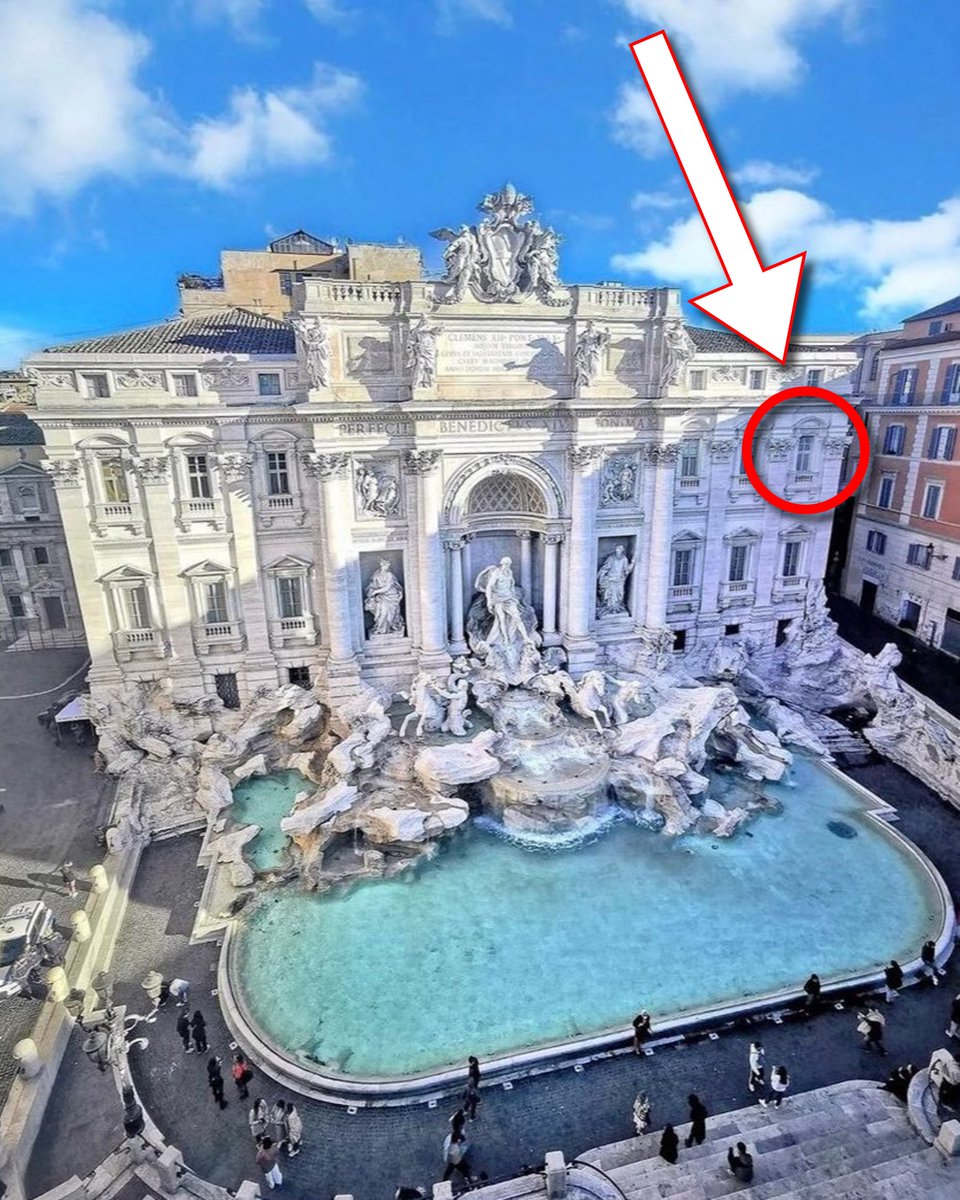
La Fuente de Trevi es una sinfonía en piedra. Pero hay mucho más de lo que parece. ¿Alguna vez te has preguntado qué hay detrás? Sus detalles ocultos contienen la clave del poder y la prosperidad de Roma... (hilo) 🧵

📢💣 Ojo a esto, porque un equipo de investigación japonés ha descubierto en 6 meses, utilizando la IA y trabajo de campo, 303 nuevos geoglifos en la Pampa de Nazca (Perú), casi tantos como se conocían en los últimos cien años. Una auténtica revolución arqueológica 🧵👇


Hilo de detalles de la pintura 🧵 1. Todo está en los ojos

🌐No te pierdas esta oportunidad ! Entre el 18 y el 21 de noviembre #SimposioSIRGAS2024, para intercambiar experiencias y avances geodésicos en la región. 📷Inscríbete hasta el 2⃣ de septiembre ➡️bit.ly/SIRGAS2024 Bogotá 📍

🌐No te pierdas esta oportunidad ! Entre el 18 y el 21 de noviembre #SimposioSIRGAS2024, para intercambiar experiencias y avances geodésicos en la región. 📷Inscríbete hasta el 2⃣ de septiembre ➡️bit.ly/SIRGAS2024 Bogotá 📍


16 COSAS QUE LOS HOMBRES APRENDEN DEMASIADO TARDE: 1. Cuanto menos digas, más importancia tendrán tus palabras.


Estoy aquí para enseñarte todo sobre la IA, acompáñame en este camino hacia el futuro. Dale 'Me gusta' ❤️, retuitea 🔁 y comenta 📝
Estoy aquí para enseñarte todo sobre la IA, acompáñame en este camino hacia el futuro. Dale 'Me gusta' ❤️, retuitea 🔁 y comenta 📝


This article provides an inside look at one of the first completely underground mobile #lidar #Transportation surveys @HNTBCorp @RIEGL lidarnews.com/articles/mobil…

Te amo, patán cívico 😍

Si necesitáis un mapa de un área del mundo, pero no tenéis claro qué PROYECCIÓN os conviene utilizar, en esta web os sugieren una de las muchas que hay en función de dónde esté esa zona del mundo, y de si queréis conservar áreas, ángulos o longitudes. projectionwizard.org/#
Agudas anomalías🔥hoy Julio22 en el norte de Argentina🇦🇷y Paraguay🇵🇾con temperaturas superiores o cercanas a los +30°C en pleno invierno austral👇 Con ~22°C BuenosAires habría tenido la noche más cálida🥵registrada en el q debería ser mes más frío del año.climatereanalyzer.org/wx/todays-weat…

This is the massive hail flow generated by the violent thunderstorms in the Milan area this morning (July 21, 2023). These are the streets of Seregno: an authentic ice river [read more (IT): buff.ly/44RA3aL]
📢The new survey software application, SurveyTools, is here to improve industry workflows. Don't miss out on the latest news🔥 "New Survey Software Application “SurveyTools” for BricsCAD" 👉shorturl.at/mLQTU #Surveying #geospatialtechnology #surveyorlife @bricsys


Disponível o replay do webinar: 3ª Norma de Georreferenciamento de Imóveis Rurais - assista o vídeo na íntegra para saber como aproveitar melhor as mudanças da norma técnica mundogeo.com/2023/05/26/rep…


#SurveyorEdThread: Best Practices for Control Points in the Field 1/9: Now that we've reviewed the importance of accurate control points and how total stations find the best fit, let's discuss the best practices for control points and tool setup in the field.

The reason why the public doesn't understand land surveyors is because the USA hasn't had a president who was a land surveyor since Abraham Lincoln. #landsurveying #history #AbrahamLincoln

Topographic Survey What is the purpose of a Topographic Survey? Topographic surveys are usually carried out in order to have an accurate record of the existing conditions of a parcel of land that is about... - landsurveyorsunited.com/almanac/topogr…

Have you ever wondered what is the difference between orthophotos, orthophotomaps, orthomosaics and true orthophotos? Here is the explanation. #EO #EOHub #drones #aerial s.bulk.ly/3iCe


This gate in Vienna is a masterpiece of optical illusion.

A collection of #AI tools for #surveyors linkedin.com/pulse/adapting…

André Große-Stolten... @AG_Stoltenberg
1K Followers 3K Following Remote Sensing 🤝 Landscape Ecology, #JLUGiessen, Hyperspectral & LiDAR, Invasive acacias, Mediterranean ecosystems, Orchards, Woody Landscape Features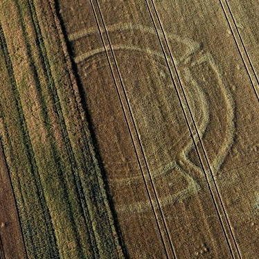
nondestructiv @NonDestructiv
1K Followers 2K Following Applying archaeological prospection and documentation methods with advanced technology to enhance heritage research and preservation.
Geosun Navigation @GeosunNav
1K Followers 4K Following Make the LiDAR/SLAM solution more affordable and applicable.
PRiSM Surveying @PRiSM_Surveying
1K Followers 1K Following Surveying & Mapping Florida (NV, NV-WR, CO, ID) 2015-2016, 2018 President, Gold Coast Land Surveyors Council - Broward 754-600-1220 / Football Coach, Hockey Dad
Biorestaurar Ingenier... @BiorestaurarIng
159 Followers 746 Following La primera EPS AMBIENTAL del país, pregunta nuestros servicios contacto:3154197438 Instagram @biorestaurar_ingenieria Facebook: Biorestaurar Ingeniería
omar oswaldo rozo @o_rozo
57 Followers 274 Following
Topografia2 @Topografia_2
1K Followers 840 Following Somos una página web dedicada a darte a conocer el mundo de la Topografía y ofrecerte noticias e interesantes recursos.
Roman Sarmiento G @romansarmientog
395 Followers 2K Following design it in Python build it in Golang, render it in Delphi and display it in GIS
GlobalCAD @globalcad
37 Followers 73 Following GlobalCAD specialises in delivering BIM and CAD services to the highest standards and in accordance with the relevant British and international standards.
Alisson @Alisson15210222
2 Followers 10 Following
Geospatial Stuff @GeospatialStuff
5K Followers 5K Following We tweet everything Geospatial related including GIS, geomatics, drones, open data, location technology, maps & much more
Katie Patrick @katiepatrick
24K Followers 19K Following Env Engineer + Action Designer 🌏. Founder @helloworldlabs 🌈. I help green leaders influence their communities to change at scale.
vGIS @vGIS_Map
2K Followers 1K Following Leading #AugmentedReality #AR-powered Construction Coordination platform. #BIM, #GIS, #3DScans and #RealityCapture. @Autodesk, @Esri and @Microsoft partner.
Karsons Consulting @KarsonsGroup
757 Followers 1K Following Karsons Consulting provide bespoke consultancy in building services design, facilities management and environmental services.
Hippo @wponeo
137 Followers 370 Following
Latam Geosystems Colo... @LatamGeosystems
68 Followers 198 Following Distribuidor oficial de productos Leica Geosystems: Servicio técnico, venta y alquiler. Especializado en equipos topográfico, medición y scaner en toda Colombia
SuperMap @SuperMap__GIS
7K Followers 5K Following GIS platform software and solution provider. Innovate Geospatial Intelligence, Elevate IT Value. #GIS #3DGIS #BigDataGIS #AIGIS #BIMGIS
Luis Velásquez @esteeslucho
202 Followers 822 Following

maria paola @mpcarrillo55
264 Followers 1K Following Para empezar debemos mirar el terreno de donde queremos sembrar todos nuestros proyectos de vida .
elmer huerfano perez @elmerhuer
93 Followers 229 Following
Olga Álvarez Velásq... @OlgalvarezVels1
1 Followers 84 Following
Camilo Correa Abril @CamiloCorrea170
3 Followers 78 Following
Oscar @Oscarentrenaten
3 Followers 26 Following
M&G INGENIERIA @mygingenieria1
3 Followers 60 Following En M&G TRANSPORTES INGENIERIA Y EQUIPOS SAS, facilitamos Productos, Servicios y Soluciones en el manejo de Información Geoespacial, y otros.
Tu marketing fácil @tumarketingfac
3 Followers 54 Following
cesar alberto @beto485
69 Followers 277 Following
SORAYA REINA @SORAYAREINA2
427 Followers 3K Following

EP | Mundo @EP_Mundo
451K Followers 271K Following Noticias del Mundo en Español. Cadena de Noticias @EP_Mundo Visítanos en https://t.co/4Zx46EOxfr
Servipolis @servipolis1
243 Followers 2K Following Empresa con más de 200 tipos de servicios para tu hogar o negocio. Tels: (312)8098738 / (312)8114988. Descarga la app para celulares SERVIPOLIS.
Luisfer Salas @luisferhd
529 Followers 5K Following Compositor Colombiano, Escucha mi música en todas las plataformas: https://t.co/MtKsP21Riu
F&S Tours @FyS_Tours
532 Followers 388 Following ¡Viaja con F&S Tours, por Colombia y el mundo a precios increíbles! #DestinosParaDisfrutar
Catastro Bogotá @CatastroBogota
30K Followers 1K Following Agregamos valor a Bogotá mediante la captura, integración y disposición de información de interés para la ciudad. https://t.co/xvXPLzte2J
ArcGIS Enterprise @ArcGISXprise
13K Followers 172 Following Map and analyze with ArcGIS Enterprise, now available on Kubernetes. Plus, see how our Operational Intelligence product suite can be used to extend your GIS.
WorldCapture @WorldIPictures
37K Followers 5 Following Life is a journey, each photo captures a moment. Live every instant, it is the essence of our story.

Aleks Buczkowski @abuczkowski
648 Followers 181 Following I'm a creative thinker. Self-confessed gadget addict. Focused on Maps & Drones. Works @PwC & @geoawesomeness https://t.co/Xdf2qaUbJO
Leica BLK Original @LeicaBLK
2K Followers 344 Following A powerful and sleek series of laser scanning and reality capture sensors. Elegantly simple. Always accurate. Digitize reality with confidence.

Asociación Colombian... @acmineriacol
16K Followers 2K Following ⚒️👷♀️👷 Representamos los #MineralesParaLaVida, la energía y el futuro sostenible de los colombianos.
ArcGIS Pro @ArcGISPro
29K Followers 89 Following The world's leading GIS software. Start a free trial: https://t.co/o47SA00Ouk ArcGIS Pro Shorts: https://t.co/7KdE6N8NuB Tech Support: https://t.co/kwb2yUrBXP
IGEO (CSIC-UCM) @IGeociencias
72K Followers 3K Following Instituto de Geociencias (CSIC-UCM) https://t.co/kcEe2k3EKN https://t.co/CYiMDd4euw Gamificación https://t.co/ewGnbgQvo1
PRiSM Surveying @PRiSM_Surveying
1K Followers 1K Following Surveying & Mapping Florida (NV, NV-WR, CO, ID) 2015-2016, 2018 President, Gold Coast Land Surveyors Council - Broward 754-600-1220 / Football Coach, Hockey Dad
USGS @USGS
779K Followers 93 Following Science is only a tweet away. Tweets do not = endorsement: https://t.co/VoRuucTNuK
Topografia2 @Topografia_2
1K Followers 840 Following Somos una página web dedicada a darte a conocer el mundo de la Topografía y ofrecerte noticias e interesantes recursos.
nondestructiv @NonDestructiv
1K Followers 2K Following Applying archaeological prospection and documentation methods with advanced technology to enhance heritage research and preservation.
Velodyne Lidar @VelodyneLidar
10K Followers 383 Following Velodyne Lidar provides smart, powerful lidar solutions for industrial, robotics, automotive, mapping, security and more. Envision the future.
AgenciaNaldeMinería @ANMColombia
29K Followers 1K Following Somos la autoridad minera colombiana. Administramos, fomentamos y vigilamos la #MineríaConPropósito de Colombia. Avenida Calle 26 No 59-51 Torre 4 Piso 8
COPNIA @copnia
5K Followers 465 Following Consejo Profesional Nacional de Ingeniería. Entidad pública que controla, inspecciona y vigila el ejercicio de la ingeniería, profesiones afines y auxiliares.
GCF @GCFDesignLtd
266 Followers 266 Following
Roman Sarmiento G @romansarmientog
395 Followers 2K Following design it in Python build it in Golang, render it in Delphi and display it in GIS
Parques Nacionales Na... @ParquesColombia
293K Followers 2K Following Autoridad ambiental en las 65 áreas protegidas que conservan la biodiversidad de Colombia 🇨🇴 Director: @luiszolmedo [email protected]
Beautiful Maps @BeautifulMaps
46K Followers 707 Following The maps and infographics most beautiful, funny and curious of the world
MapPorn @MapPornTweet
80K Followers 2K Following Official Twitter account of /r/MapPorn. Reminder: There are high-resolution images of the maps if you follow the Reddit links.
ClearEdge3D EdgeWise @EdgeWise_3D
855 Followers 245 Following Faster, more accurate 3D modeling. @ClearEdge_3D
GlobalCAD @globalcad
37 Followers 73 Following GlobalCAD specialises in delivering BIM and CAD services to the highest standards and in accordance with the relevant British and international standards.
Survey Solutions - So... @SurvSol_SE
492 Followers 756 Following South East division of Survey Solutions. Experienced and trusted land, measured building and underground surveyors.
GeoSpatial Next @geospatial_next
1K Followers 976 Following Trends, Insights & Network for Geospatial Community
omar oswaldo rozo @o_rozo
57 Followers 274 Following
Alisson @Alisson15210222
2 Followers 10 Following
Parrot official @Parrot
72K Followers 373 Following

GeoInformatics @Geoinformatics1
12K Followers 4K Following GeoInformatics, knowledge for surveying, mapping and GIS Professionals. https://t.co/9lnwWufBK4
Geoawesome @geoawesome_dgtl
25K Followers 6K Following Open and inclusive community platform for geospatial experts and enthusiasts. Building bridges across sectors and industries. All things GEO awesome 🌎 🛰🗺🚀
Karsons Consulting @KarsonsGroup
757 Followers 1K Following Karsons Consulting provide bespoke consultancy in building services design, facilities management and environmental services.
Katie Patrick @katiepatrick
24K Followers 19K Following Env Engineer + Action Designer 🌏. Founder @helloworldlabs 🌈. I help green leaders influence their communities to change at scale.
Open Geospatial: OGC @opengeospatial
27K Followers 230 Following OGC’s member-community of experts makes location data Findable, Accessible Interoperable, and Reusable (FAIR) through #innovation #collaboration and #standards
vGIS @vGIS_Map
2K Followers 1K Following Leading #AugmentedReality #AR-powered Construction Coordination platform. #BIM, #GIS, #3DScans and #RealityCapture. @Autodesk, @Esri and @Microsoft partner.
Bosshard Surveying @bosshardsurvey
1K Followers 187 Following Bosshard Surveying is a full service professional land surveying company. We serve all of Wisconsin. 920-293-4001 262-527-4672
SCCS @SCCSSURVEY
2K Followers 189 Following The UK's leading provider of surveying equipment and solutions for positioning and measurement. Part of @HexagonAB. #Surveying #Monitoring #DigitalConstruction
Marce Perdomo Sierra @perdomo_marce
45 Followers 100 Following
Latam Geosystems Colo... @LatamGeosystems
68 Followers 198 Following Distribuidor oficial de productos Leica Geosystems: Servicio técnico, venta y alquiler. Especializado en equipos topográfico, medición y scaner en toda Colombia
Consejo Profesional N... @CPNTCol
765 Followers 578 Following En la profesión de la Topografía, cumplimos la Inspección, Vigilancia y Control atribuidas por la Ley 70 de 1979 y el Decreto Reglamentario 690 de 1981.
Laser Scanning Forum @LaserScanning
6K Followers 44 Following A leading industry online knowledge base that has grown to become a trusted and influential resource worldwide, for anyone. Supporting knowledge transfer.
Hexagon Safety, Infra... @HexagonSIG
10K Followers 609 Following Improving resilience and sustainability for the world’s critical services and infrastructure | Part of @HexagonAB
☁ 𝗖𝗹𝗼𝘂�... @CloudCompareGPL
3K Followers 71 Following Open source 3D point cloud processing and editing software
NEI @NEIGPS
420 Followers 347 Following NEI is your one-stop-shop for survey, MGIS, marine, public safety, and construction sales, service, support, training, fleet management and equipment rentals.
Geospatial Stuff @GeospatialStuff
5K Followers 5K Following We tweet everything Geospatial related including GIS, geomatics, drones, open data, location technology, maps & much more
Aeronáutica Civil @AerocivilCol
175K Followers 285 Following El cielo más cerca de los colombianos 🇨🇴✈️ [email protected]
Drone Analyst @droneanalyst
40K Followers 1K Following Your trusted partner in navigating the young drone market and determining what is new market hype versus market reality. Run by @Dave_Beno
sUAS News @sUASnews
43K Followers 2K Following Unmanned Aviation,fixed wing and rotary UAV stories from around the world.Trends for United States
You might like