Carlos (Geoalgor) Miranda @geoalgor
Carlos Miranda Geo+Analista geoalgor.cl Chile Joined December 2011-
Tweets27
-
Followers26
-
Following136
-
Likes3

Requesting public comment on the Features and Geometries JSON – Part 1: Core Standard, which specifies extensions to the GeoJSON format that support certain useful geospatial application contexts. Comments due June 24. bit.ly/3x7Dizo


This article looks at how a school district is using #3D laser scanning to improve school safety @FARO_TechInc blog.lidarnews.com/school-safety-…


El periodista @C_Guisasola recibió el premio a “Mejor trabajo periodístico” en la XVI entrega de los #PremiosCaminosMadrid por su artículo “Madrid sería un drama sin tanques de tormentas”, publicado en El Mundo. Así ha valorado este galardón 🎥 #ICCP #YoSoyCaminosMadrid #Madrid
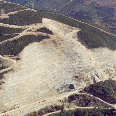
Hoy comenzamos en #geotecnia el tema de estabilidad de taludes. La importancia del tema queda de manifiesto con esta noticia y estas imágenes canalsur.es/noticias/andal…

🚨 Calling all graduate students and postdoctoral fellows interested in learning more about heliophysics! The Heliophysics Summer School is BACK and applications are due March 3. For more information on this year’s sessions and to apply visit: go.nasa.gov/3HH1me5

GIS/Python Specialist at VistaCare Communications Services of Canada Inc. GISPython Specialist Bedford NS Bedford NS VistaCare Communications is a leading technology solutions provid... #Python #epicjobs zobjobs.com/job/gis-python…

Mapping the World's Fungi: Scientists from Netherlands, Canada, the US, France, Germany, and the UK have created a collaborative effort, called the Society for the Protection of Underground Networks (SPUN). #gis #geospatial bit.ly/31G2Xj9

Hosting Mapathon for Southern Turkey? We’re looking for organizations which can host mapathon with their local community to map affected areas in Southern Turkey. Please let me know if you’re interested in to host one! Tag organizations which might host a mapathon!

Mañana lanzamos nuestro primer Bootcamp avanzado 👀
Did you hear? The reports documenting the research conducted under Testbed-17 are here! The public reports cover #IoT #Sensor Integration, #MovingFeatures from video, Data-centric #Security, #CloudNative Formats, and #interoperability thru #APIs. bit.ly/3vz9N4R #OGCT17

Profesores del Grado en #Geoinformación y #Geomática del @CUMe_UEx, han elaborado este mapa en 3D del relieve de la isla de La Palma donde se observa la ubicación de la fisura principal de la erupción. Puedes verlo también usando gafas de Realidad Virtual➡️bit.ly/LaPalma3D


Densidad de antenas celulares en región centro de Sudamérica 📶📱


Amidst the new realities of war, Air Raid Sirens have been a constant presence in my daily life, and the lives of millions of Ukrainians. 🚨🇺🇦 To explore alert patterns across different regions, I visualized them on a timeline. observablehq.com/@mourner/sirens
For those who missed my talk about personal data viz at @DevsforUkraine — here’s the recording. 📊 Watch, share, feel free to ask any questions and let me know what you think 🙏🇺🇦youtu.be/lK11UP1qOLw
It’s time for smarter EV navigation! Our new Electric Vehicle Routing makes it easy to build intuitive EV trip planning into your apps, with optimized routes that include charging stops. Find out how to get early access: mapbox.com/blog/electric-… #EV #electricvehicles
📢Atención #GISlovers 📢 Mañana hay webinar con el nuevo producto de @CopernicusEU para superficies terrestres potencialmente afectadas por inundaciones. No esperéis a que vengan las lluvia a contároslo. Tenéis el webinar aquí ⤵️ y el enlace en el QR ↗️

Learn about earthquakes and tectonics of the Himalayas in this informative video --> youtu.be/5VjaSFEf4BU
Cómo descargar e importar #estilos desde QGIS.org mappinggis.com/2020/12/como-d… #qgis
We are all fighting the global pandemic of the #COVID19 virus. Team of scientists at the @UCJaguars developed a system powered by #GISCloud to track virus cases in #realtime! This will help locate patients and address them to Health Centers in the area. giscloud.com/blog/covid-19-…


CamilleAgnes @844at38PhTn19Y6
63 Followers 7K Following
Zhe Zhu 🌎🛰️ @GERSLab
4K Followers 2K Following Associate Professor @UConnNRE, Director of Global Environmental Remote Sensing Laboratory, Associate & Special Issue Editors of RSE & SRS.
Rafael Beltran Ramall... @RafoBeltran
3K Followers 5K Following Expert in Land Administration, Participatory Cadastre & Geotechnology | GovTech Specialist | Professor & UNIGIS Fellow | Expert in Digital Transform | My Web 👇
COMUNIDAD SIG @COMUNIDAD_SIG
5K Followers 976 Following #Oportunidades y #Noticias sobre #Sistemas de #Información #Geográfica - #SIG - #GIS y #Catastro | IG: @comunidad_sig
aminadomapa @aminadomapa
151 Followers 1K Following Procura dicas e macetes pra fazer seus mapas digitais? Dicas próprias e curadoria de dicas para auxiliar seu trabalho ---EM CONSTRUÇÃO---

Raúl BY. @RaulBY1965
30 Followers 100 Following
Geoidea @geoidea
1K Followers 1K Following We are a GIS consulting business dedicated to help answer a fundamental question: Where? Geoidea GIS data journalism project is @mapadenoticias

José María Martíne... @jmmluna_sig
917 Followers 2K Following GIS Project Manager & Java Developer | Software engineer. NodeJS, Web & Open Source. #GIS #Geospatial #map #WebMapping Cofounder @geowe_org @RtcMapping
GeoWE @geowe_org
2K Followers 2K Following Free GIS Platform for advanced editing of geographic data on Web | Free Software project | #GIS Online | #Webgis #Geospatial #map #WebMapping
IAPG Geoethics @IAPGeoethics
3K Followers 3K Following International Association for Promoting Geoethics (IAPG). IUGS, AGI, GSA, GSL, CFES, CIPSH affiliated. 37 national sections. 3301 members in 130 countries.

Global C Technology @GlobalCodeTech
73 Followers 233 Following Somos una empresa dedicada a la implementación de nuevas tecnologías emergentes ofrecemos soluciones confiables para el Internet de las Cosas (IoT).
Dario Ceballos @DarioCeballos15
368 Followers 1K Following Director EEA Delta del Paraná. Agrónomo de formación y ecólogo de deformación. Hincha de Otamendi Fútbol Club. Seguidor de utopías y justicia social
Juan Mc Gregor @jmc2307
1 Followers 32 Following
Patty Chen @pattysg29
186 Followers 2K Following
Geo-matching.com @Geomatching
18K Followers 19K Following https://t.co/3gwCkbV0gR The world’s largest product platform for surveying, positioning and machine guidance.
GIS Cloud @GISCloud
18K Followers 3K Following Operating on the fastest map engine available, we offer cloud-based GIS solutions for data collection, sharing, collaboration and publishing: [email protected]
GIS and Science @GISandScience
30K Followers 10K Following Sharing issues and applications of geospatial technology for scientific research and understanding. Tweets by the @Esri Science Team with @deepseadawn
What is GIS? @GISdotcom
23K Followers 15K Following GIS lets us visualize, question, analyze, interpret, & understand data to reveal relationships, patterns, & trends.
Cristina Ayala @cristinaayala72
23 Followers 63 Following
Luis Hernán🌳🌳�... @lhernan_g
688 Followers 4K Following ...amando la realidad que construyo y creando bosques urbanos para todes activamente...
Sandra Princesita @lunita_1040
1 Followers 67 Following
Centro Geotécnico @geomecanica_cgi
734 Followers 634 Following Twitter oficial del Centro Geotécnico Internacional - CGI. Somos una organización que ofrece los servicios de capacitación, asesoría, consultoría y estudios.
Orlando Patricio @newyorkpresence
2K Followers 2K Following events wine food testing #NY #OH #USA #gourmet #organic
Superhive (formerly B... @superhivemarket
40K Followers 220 Following The indie market for Blender creators. Proud sponsor of the Blender Foundation. Buy & Sell #b3d assets, addons and training. Made with love by Autotroph.
Blender Studio 🔶 @BlenderStudio_
112K Followers 3 Following The Creators Who Share. Blender Studio is part of the @Blender project.
Blender Artists - INA... @BlenderArtists
128K Followers 46 Following We're no longer posting on X. Read more here: https://t.co/jPqeFpxNFG
ArcGIS Pro @ArcGISPro
29K Followers 89 Following The world's leading GIS software. Start a free trial: https://t.co/o47SA00Ouk ArcGIS Pro Shorts: https://t.co/7KdE6N8NuB Tech Support: https://t.co/kwb2yUrBXP
OPENGIS.ch @OPENGISch
3K Followers 35 Following We are Swiss-made full-stack GeoNinjas. We offer personalised opensource geodata solutions that deliver great value. Support!? guaranteed, with SLA!
GRASS @GRASSGIS
5K Followers 210 Following GRASS news, tutorials, and other resources on geospatial. Also at https://t.co/oVs3uafsUf (@[email protected]) #GRASSGIS #OSGeo
FalladaMente @FalladaMente
9K Followers 632 Following A veces entiendo algo de volcanes 🌋 Sometimes I understand something about volcanoes 🌋
Geoparkea @geoparkea
8K Followers 1K Following #BasqueCoast UNESCO Global Geopark | Euskal Kostaldeko UNESCO #Geoparkea | #CostaVasca Geoparque Mundial de la UNESCO. Instagram ➡️ https://t.co/b80KFmd9AI
Foro de los Geoparque... @GeoparquesEsp
7K Followers 3K Following 18 territorios declarados #Geoparques de la #UNESCO en España 🇪🇸 Ven y descubre la historia de la Tierra #RespiraGeoparques
Mike Wulder @mikewulder
14K Followers 6K Following Senior Research Scientist with the Canadian Forest Service. 🍁 #Landsat super-fan. #Lidar. #Forests. #Remotesensing. 🌲🛰 Member of the #OrderOfCanada. 🎖
José Carlos Rico @jcricocordoba
611 Followers 534 Following Arquitecto en Citylab360. (Experto en SIG por la UHU) Pasión por todo lo que tenga que ver con los datos y su aplicación en la gestión de ciudad.
Geólogos del Mundo @Geologos_Mundo
10K Followers 906 Following ONG que utiliza la geología para ayudar a las comunidades de paises en desarrollo a obtener agua potable y en la prevención de desastres naturales.
GeoSIG.C.A @GeoSIG42
37 Followers 92 Following
MetMEX | Información... @metmex
212K Followers 744 Following Jorge Garza meteorólogo sector privado, fundador y director de @metmex @metmexbcs. 18 años de ser la mejor fuente meteorológica. https://t.co/8pRshywef3

CUMe_UEx @CUMe_UEx
1K Followers 904 Following Centro Universitario de Mérida de la Universidad de Extremadura - @infouex https://t.co/4sjU5bIZBM
Andrea - The3Dbeginne... @The3Dbeginner
33 Followers 227 Following 💻Iniciada en el mundo de Blender 3D. 🎥Muy fan de Marvel!! ✈️Viajar.
Blender 🔶 @Blender
360K Followers 4 Following Official account of the Free and Open Source 3D creation suite. Blender is free to use for any purpose, forever. 🧡 #b3d
OpenLayers @openlayers
16K Followers 18 Following An open source JavaScript library for creating interactive maps from any kind of geospatial data
Leaflet @LeafletJS
29K Followers 1K Following Leaflet, an open-source JavaScript library for mobile-friendly interactive maps 🍃🇺🇦
CARTO @CARTO
31K Followers 6K Following Spatial analytics built for the cloud. Sign up for your free 2-week trial: https://t.co/K3o3gkbN5l
Mapbox @Mapbox
75K Followers 2K Following Mapbox powers navigation for people, packages, and vehicles everywhere. Register for BUILD with Mapbox.
QGIS @qgis
64K Followers 63 Following Official account of QGIS - the user friendly Open Source Geographic Information System
GIS and Beers @GIS_and_Beers
9K Followers 1K Following ¿Hay algo mejor que un buen #mapa? Sí, un mapa en compañía de #cerveza bien fría. Lo importante siempre es latitud
COMUNIDAD SIG @COMUNIDAD_SIG
5K Followers 976 Following #Oportunidades y #Noticias sobre #Sistemas de #Información #Geográfica - #SIG - #GIS y #Catastro | IG: @comunidad_sig
EarthScope Consortium @EarthScope_sci
57K Followers 883 Following EarthScope Consortium is a new organization formed by the merger of UNAVCO and IRIS. Operator of the NSF GAGE and NSF SAGE Facilities. #NSFfunded
Mapify IoT @mapify_iot
153 Followers 160 Following Create your IoT application without a single line of code.
Topofoto @fotogrametria
67 Followers 1 Following Servicios Profesionales de Fotogrametría y Topografía
GEOGRΛMΛ @Geograma_
6K Followers 677 Following Capturamos e integramos #geodatos , para mejorar las decisiones de tu organización - #GIS, #location Intelligence
Udemy en español @udemy_es
37K Followers 1K Following Explora todas tus posibilidades gracias al e-learning. #KeepGrowing Soporte: https://t.co/IUmjfVfzHJ
Código Facilito 🐊 @codigofacilito
124K Followers 463 Following La plataforma de aprendizaje para desarrolladores.
Cristina Gil Díaz @Cristimeteo
116 Followers 168 Following Doctoranda UPC sobre teledetección activa y pasiva de las interacciones ✴☁️. Máster Meteorología UCM. Física UGR. Amante de los animales 🐶🐭🐰
Bloc de Ingeniería @BlocIngenieria
26K Followers 749 Following Pasión por la ingeniería. Defensa a ultranza de la ciencia. I+D+i en @es_ambling Máster SIG y Teledetección. Máster BIM.
Estudios Gis @estudiosgis
5K Followers 498 Following Más de 25 años innovando en Sistemas de Información Geográfica, Desarrollo de aplicaciones geográficas. Gestión y telegestión de activos. Inventarios.Teledetección y SIG @Tel_y_SIG
5K Followers 2K Following Especialización en Teledetección y Sistemas de Información Geográfica aplicados al estudio de los recursos naturales y la producción agropecuaria - FAUBA
SiteGround @SiteGround
136K Followers 3K Following Managed #WordPress hosting with top-rated 24/7 support 💻 Local accounts: 🇪🇸 @SiteGround_ES, 🇮🇹 @SiteGround_IT, 🇩🇪 @SiteGround_DE and 🇫🇷 @SiteGround_FR
Mac Maps Data GIS @MacMapsDataGIS
741 Followers 279 Following The Maps, Data, GIS Centre supports the geographic, geospatial, and research data needs of students, staff and faculty at McMaster University.
Patrick DeLuca @McMasterGIS
357 Followers 60 Following GIS Specialist / Lecturer and Administrator of McMaster's Esri Canada's Centre of Excellence for GIS
GeoNe.ws @GeoNe_ws
7K Followers 2 Following Mastodon: https://t.co/qvSSThMkXA Bluesky: https://t.co/UWmVuPL8SB GIS and Geospatial related news and information. // by @michelstuyts.
SPLIT Remote Sensing @SPLITRS
177 Followers 141 Following SPLIT RS - professional remote sensing summer school
ASPRS @ASPRSorg
4K Followers 48 Following Welcome to the official X page for the American Society for Photogrammetry and Remote Sensing. LinkedIn: https://t.co/8Vpn4kKNld IG: https://t.co/mUmEfRsiWz
Trognon @TrognonPvtLtd
97 Followers 79 Following Advancing Geospatial Tech, Environmental and Research capabilities for individuals and organizations across the world.
MapStore 🇮🇹 @mapstore2
1K Followers 38 Following Throw geospatial data at me, I'll do my best to put them on a map. Special thx to OL, LL and ReactJS!
DRONE/eVTOL/U-SPACE @JVGKabala
1K Followers 761 Following Movilidad Aérea Avanzada (AAM, UTM, AIRTAXI)
SRM__Consulting @SRM__Consulting
489 Followers 426 Following Solutions developed with #ArtificialIntelligence for applications and professional services in #LocationIntelligence, #GIS, #cartography. Ipsilum developers
MappingGIS 🚀🌍 @MappingGIS
24K Followers 296 Following Formación que impulsa tu perfil GIS. Cursos online de #QGIS #R #IA #PostGIS #webmapping #python #GeoServer #OpenLayers #Leaflet #MapStore #teledeteccion
GnoTech @gno_tech
51 Followers 5 Following Gnosis Technology Ltd (GnoTech) is a drone service company that offers aerial photography services as well as related Geographic Information services.
gvSIG project @gvsig
11K Followers 235 Following Free Software project to develop easy to use Geographical Information System products and a great community
Alibaba Cloud @alibaba_cloud
1.1M Followers 986 Following Computing for the Value beyond ComputationTrends for United States
You might like