Search results for #KYwx

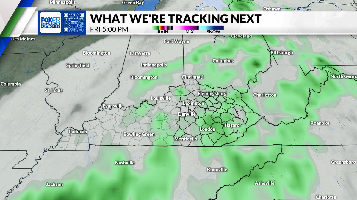
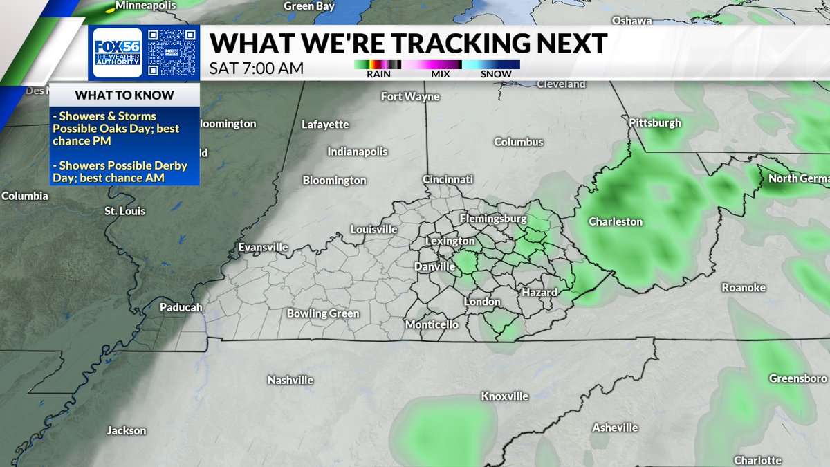
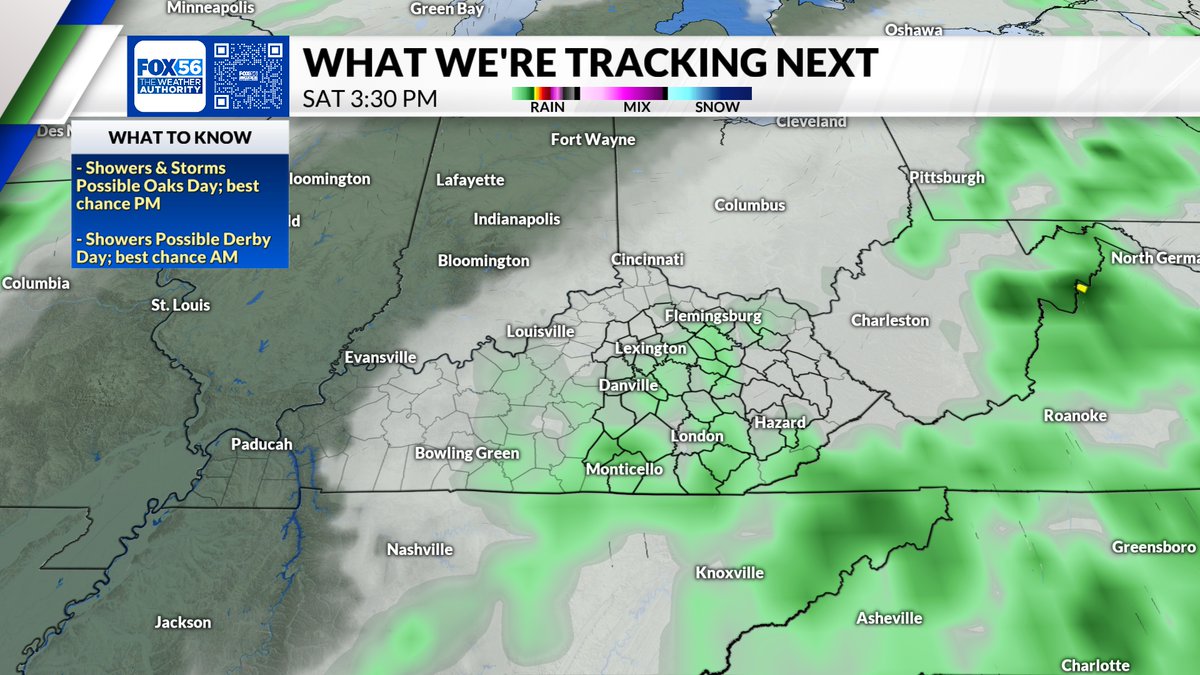
We have rain and storm chances moving in overnight ... but it won't be our last chance to see showers this week! As of right now, we may have to deal with some isolated showers on Oaks and Derby day #kywx


Radar 1:20 pm 4/29/24: Showers and T-storms continue to push across Southern Illinois and into SW Indiana and West Kentucky. The strongest storm is pushing through Edwards and Wabash County, IL. We could see some small hail with this storm. #tristatewx #inwx #ilwx #kywx


4/29/24 Midday Update: Cloudy to Mostly Cloudy skies. Showers and a few T-storms will continue to develop across Southern Illinois. This activity will increase and spread across the area. Temperatures are in the mid 60's to low 70's. #tristatewx #inwx #ilwx #kywx

Showers and thunderstorms increase from west to east later today into Tuesday. We need to watch for a corridor of heavy rains that can cause local issues during this time. The best chance is across central and south central Ky. Here's the future radar from the Hi Res NAM. #kywx


Some Gravity Waves in Mercer County. #kywx @Kentuckyweather @jloganwxguy


Air quality is forecast to be Good Monday and Tuesday. Follow live conditions here: airqualitymap.louisvilleky.gov #AirQuality #kywx #inwx #lmwx #Louisville #pollution


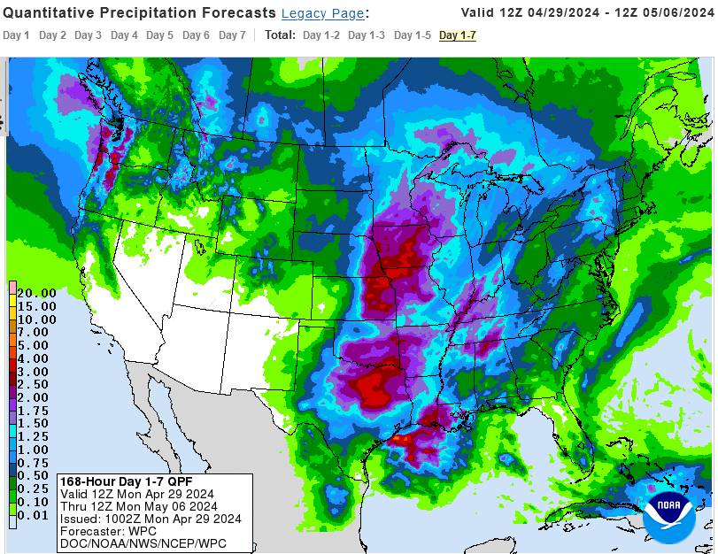
Some parts of southern & eastern KY have not seen much rainfall these past two weeks. The @NWSWPC forecast does depict significant rainfall over mainly central/western parts of the state over the next seven days. #kywx


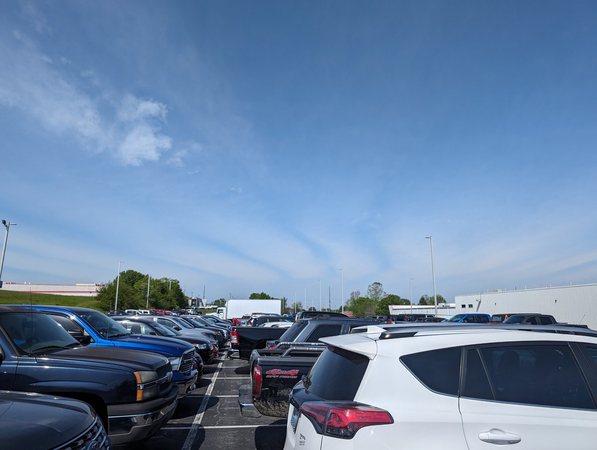
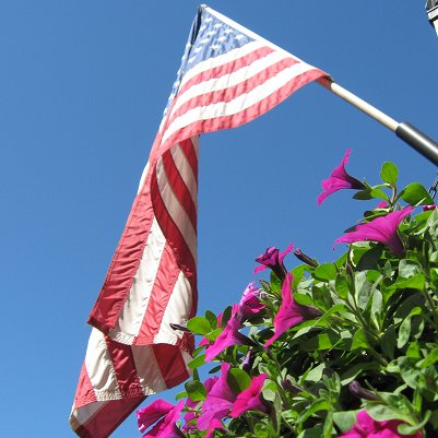
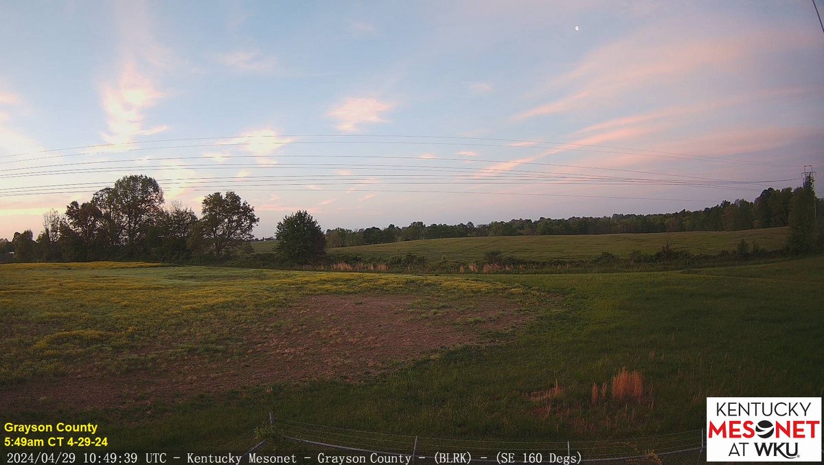
High clouds appeared like cotton candy in the skies over the Commonwealth on what is the start of #KentuckyDerby150 week! 👀at the waning gibbous moon 🌖from our shot facing SE in Grayson Co. near Leitchfield! Expect clouds to thicken today with rain on the approach. #kywx


If you had power to Use a tornado or hurricane at your choice which one? #hail #thunder #lightning #Severeweather #SevereThunderstormWarning #Weather #WeatherUpdate #tornado #tornadoWarning #kywx #stormchase #stormchaser #wind #windy #kentucky #indiana #inwx #lawx #txwx #miwx…


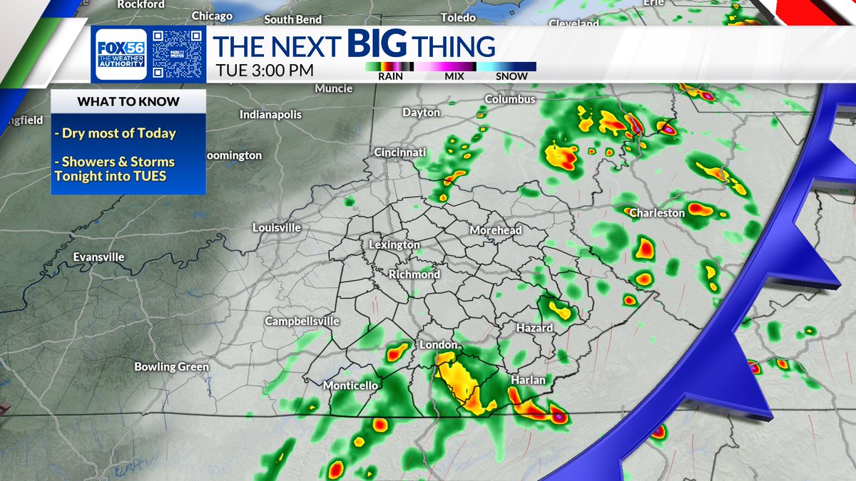
Dry most of Today, but showers are possible by evening. Showers become likely overnight into Tuesday morning. Drying out from west to east Tuesday afternoon. #TheNextBigThing #kywx


4/29/2024 LIVE TristateWx Streaming Doppler Radar #tristatewx #INWX #ILWX #KYWX x.com/i/broadcasts/1…
#tristatewx #inwx #ilwx #kywx 4/29/24 Morning Update: A weakening line of Showers and T-storms will continue to push off to the ENE this morning for areas along and North of I-64. An outflow boundary will continue to push off to the Southeast. Temperatures range from the upper…

Breezy and warm with increasing clouds Today. Isolated showers possible into the early evening. Better rain chances overnight into Tuesday AM. #kywx


kywx @kywx
58 Followers 2 Following
#kywx Social @kywxSocial
158 Followers 50 Following User reported, user contributed. Send Kentucky Weather reports using #kywx! Follow @kywxSocial to keep up with current KY weather! Part of @SocialWeatherUS.
Kentucky Weather @CentralKYwx_
77 Followers 8 Following Breaking Weather Information for Centeral Kentucky!
Ky @Kywx13
34 Followers 24 Following
Marc Weinberg @MarcWeinbergWX
36K Followers 223 Following I am the Chief Meteorologist at WDRB in Louisville, KY. I love weather and I am blessed to share my passion on TV. My tweets are my own opinions. #kywx #inwx
WBKO First Alert Weat.. @WBKOWeather
28K Followers 150 Following Local. First. Now. The First Alert Weather team from @WBKOtv tweets the latest alerts, conditions & forecasts for #SCKY! #wbkowx #kywx #bgky
Clint Smalley @ClintKYwx
187 Followers 415 Following Kentucky Born and Raised. Ohio University Meteorology Grad.


kywx @BernardoErcoli
396 Followers 2K Following I was born, I ate, I grow up, etc (End of Thinking Capacity).
Kuidaore太郎 @sDX27by8qv3KYWx
348 Followers 920 Following 元プリンスホテル料理長。 新宿飲食店経営 飲食好き過ぎて収入の1/3は食費 全国にある美味しいグルメ、食事、ランチ、ディナー🍽をお届けします❗️ 全国の美味しいグルメをあなたに😋


mdzxe @KYwx4dx5d
9 Followers 6 Following
لـ روح أبـي�.. @MZEauLw3KywxXzB
39 Followers 115 Following
るな🦕ネイル�.. @kywx_n
88 Followers 127 Following 渋谷駅8分🌿ネイルモデル様募集中🫧研修生の為通常価格より半額以下でご案内致します🫶デザイン2,000円、シンプル1,000円、フットは+500円🌷興味のある方はDM下さい。お直し、返金はできません。研修生のため仕上がりご了承ください💦遅刻、キャンセルはご遠慮ください。※女性専用サロンです💅🏻
もんぶらん @bsxonPsy4KYwxSl
24 Followers 37 Following


Nathaniel The new Wea.. @NathanielKYWX
36 Followers 103 Following

Brandon Spinner WCPO @wxSpinner89
9K Followers 2K Following 4x Emmy Nominated, Award Winning Meteorologist in Cincinnati, OH #OHwx #KYwx @ValpoU Grad. Fan of Jeff Gordon #Team24, #Cubs, #Blackhawks, #Dolphins, & #Bears
Register 4 @wwo_kywxS
7 Followers 1 Following

Rin @e_kywx
65 Followers 213 Following 成人済//地方住み//新参審神者*刀ミュ中心🤍立花裕大🤍笹森裕貴❀江❀🌊 基本壁打ち*FC⇒刀ミュ、立花裕大、笹森裕貴 🗝▶︎ @z9v_71
আকাশ @UMZJOwKYWx4gTfx
16 Followers 0 Following
فؤادي بن عب�.. @zN3f2QWVfaKywx8
27 Followers 81 Following

محمد امين ح�.. @bMeuU7zFSkbKywx
6 Followers 3 Following


soar @kywx2000
32 Followers 1K Following
Simonin killian @kywx2z__r
2 Followers 13 Following

⭐ @Ewsw4vj9UamKYWX
6 Followers 11 Following
مطارق العبد.. @nT46RHRdKYwx1EQ
1 Followers 5 Following
KYWx @ruffnec72701140
8 Followers 18 Following
KY Weather Opinion �.. @KYWxOpinion
2 Followers 7 Following We provide weather coverage and opinions for the Bluegrass State.
ひなひな @KVxGRE4mKywx20D
6 Followers 16 Following
al @WzqPHUvjKywx9bf
0 Followers 0 Following
J.R. Lewis Hodge @KYWxMn9901
20 Followers 0 Following If you believe in something go after it with all you've got if you fail get up dust yourself off and try again, never give up even until your last breath!!!!
Maiai @lwLvzzqJmKYWxIJ
26 Followers 0 Following

工藤照美 @W5mOU97bMQsKYWX
0 Followers 9 Following
北見一孝 @tF4IqHPJHjnKYwx
6 Followers 7 Following
Mel @MugsyMel
600 Followers 610 Following Appreciation 4 weatherpeople & nature photos. #TWDfamily. Ex-Singer. Cloud & WKYT wx watcher. #KyWx Mom x2. Crazy cat lady. PokemonGo daily player. I ❤️Jesus.
Екатерина @qFWgn8KYWX1plsK
1 Followers 11 Following
アカウント変え.. @kywx15
83 Followers 152 Following
محمد طلعت م�.. @BIpSUy7KywxDom3
7 Followers 25 Following

ملك @WGo68KYWx8CXsOC
1 Followers 1 Following
อทิตยา �.. @8wv82KywxSx94dM
2 Followers 13 Following


دانيال الكن.. @XyufLryKYWxGdP9
0 Followers 1 Following
Heronsbill's cat @nSsc9KYWx3PT74y
3 Followers 16 Following

Kywx _ @Kywx10
1 Followers 1 Following


HASSAN YASSER @KYwxTJgdvJy7df0
0 Followers 24 Following


ElvaJudd @VWSbXi0KYwx2Dpm
0 Followers 0 Following

وافي السلمي @lPckfw73PvbKywx
0 Followers 24 Following

محمد سليمان @KYWx9oNbwLk6vfZ
5 Followers 260 Following أبويوسف أخصائي علاج بالحجامة وعلاج بسم النحل والاعشاب
大山歩之渡 @hElqxKYWx119850
0 Followers 13 Following

カール @bO6ulALOyvKYWX4
0 Followers 0 Following

せいかくオバフ.. @nTG13KYWxZ74207
1 Followers 38 Following

吴宪 @kywx88888
0 Followers 0 Following

ต้น @ri9LypiKYWxT89j
1 Followers 6 Following
لاشي @KywxHNWjjOziika
1 Followers 40 Following لا أنتمي لثقافة المهمشة أحب التصاميم لهندستي العالميه
ゆうき @cbktRhKywxP4T3G
0 Followers 4 Following
大谷奈穂子 @kywx4AswnmkAmMg
0 Followers 0 Following
跑调的音乐人 @1xAq8yW5y5KYwxK
0 Followers 0 Following
СанькаЙота @kywxXsLrTf5en2F
0 Followers 0 Following
DoloresHaydn @au0KywxZfyb1b6
0 Followers 0 Following
عصمت الله ا�.. @ldzKYwxOsaFW4Hs
0 Followers 17 Following
Clayton Bylsma @Clayton0kywx
1 Followers 0 Following
Kywx @eeduardomoriano
0 Followers 1 Following
吴宪 @kywx888888
0 Followers 1 Following
مهدي العزاو.. @zGzDzKYWxFBjZfp
1 Followers 35 Following
知優 坂下 @cr3AiaZdvKYwxEB
0 Followers 0 Following

はらはら @8fKywxPZZeJjDLy
0 Followers 4 Following
พระจันท.. @jl0KYWX9RbfSAYv
0 Followers 0 Following
Wajid afridi @KywxT
3 Followers 38 Following
吴宪 @kywx8888
0 Followers 3 Following