Search results for #Pix4Dreact

This article features a hands-on project where university students used drones and #Pix4Dreact to map their campus grounds, identifying new building locations and planning recreational areas: pix4d.com/blog/drones-fo… #dronesforgood #Pix4Dreact #Pix4D


Starting August 1st, there will be a change in the basemap provider across several #Pix4D applications: #Pix4Dmapper (v4.10 and above) #Pix4Dfields (v2.9.6 and above) #Pix4Dreact (v1.6 and above) #SurveyDronesIreland

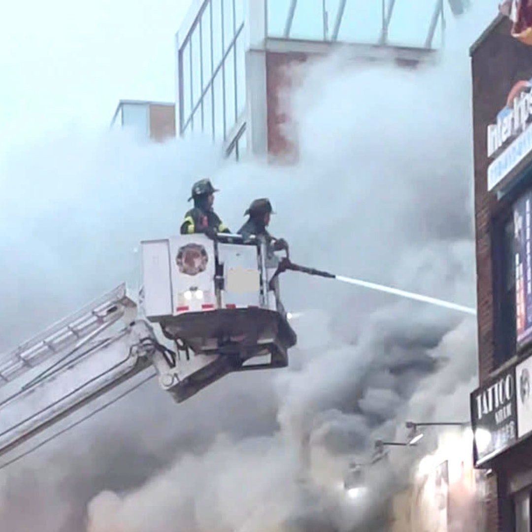
🚨 #PIX4Dreact is built for #emergencyresponse teams needing speed and accuracy. Gain detailed insights by classifying objects of the same class like cars or damaged areas with a single annotation! Try PIX4Dreact for free hubs.li/Q02WCB-00
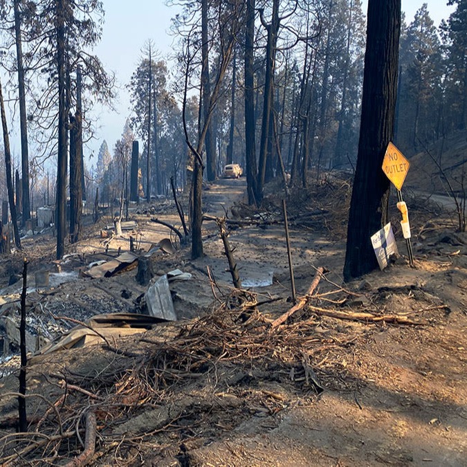
As wildfires cause widespread devastation, having accurate, up-to-date information is essential for saving lives. With #PIX4Dreact, responders can create maps from aerial imagery in minutes. Learn how to use PIX4Dreact for fire response: hubs.li/Q02L5J8B0
#PIX4Dmatic 1.64.0 #PIX4Dmapper 4.9 #PIX4Dcloud #PIX4Dfields 2.7 #PIX4Dreact 1.5.1 #PIX4Dsurvey 1.64.0 #PIX4DcapturePro 1.4.0 #PIX4Dcatch #SurveyDronesIreland

Students use #PIX4Dreact to learn #photogrammetry, processing drone images to create maps, identifying spaces & buildings for situational awareness. Advantages: ➡️ Immediate area assessment ➡️ Enhanced coordination ➡️ Offline processing Read more here: hubs.li/Q02DpvKv0

国産ドローンSOTENの機能紹介。 【オルソ画像撮影の調査(測量)飛行】 標準セットで可能。すでに港湾土木など公共土木の現場で使われています。PIX4DmapperとPIX4Dreactが正式サポート。 youtu.be/AHTUyPwawmU?si… #SOTEN #蒼天 #国産ドローン #ドローン #ACSL #PIX4Dmapper #PIX4Dreact #Metashape
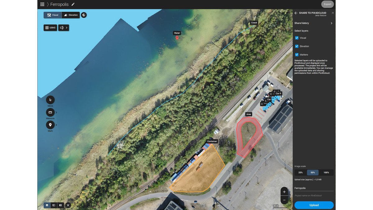
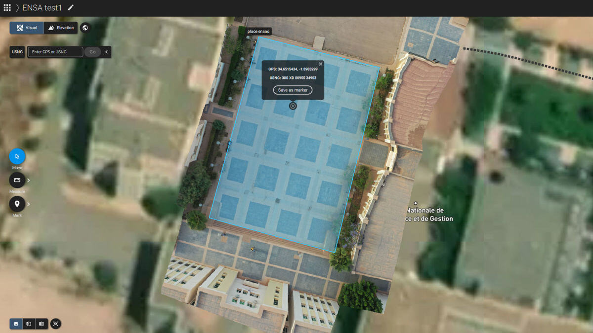
🌏 Empowering the youth for positive change with #PIX4Dreact. Morocco Flying Labs and Pix4D educate students to tackle local challenges through mapping skills and #photogrammetry. Teaching future generations to use drones for good: hubs.li/Q02hHfNh0 #DronesForGood

Following the earthquake in Turkey, rescue teams effectively used drones and #PIX4Dreact to respond to the disaster. We cover ten critical ways drones can be used for emergency response in our article: hubs.li/Q02bvhtC0

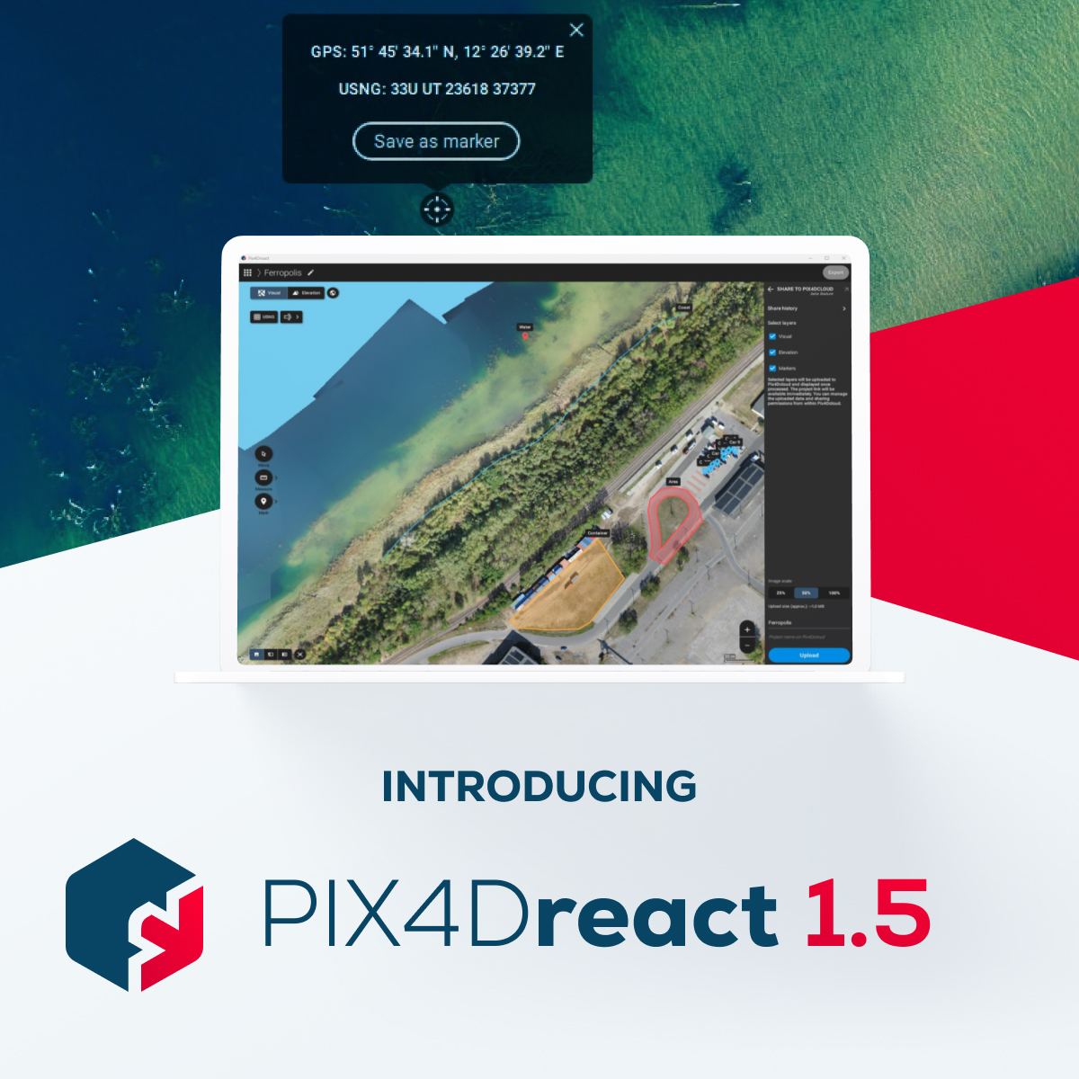
Quick and effective action relies on precise location information. #PIX4Dreact 1.5 offers the option to switch from decimal degrees to degrees, minutes, seconds. The new update offers the option to export high-resolution JPEGs for large-format printing: hubs.li/Q028GlqL0

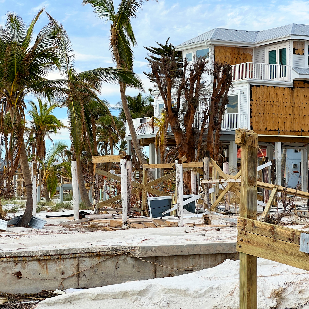
Drones played a vital role in damage assessment after Hurricane Ian. #PIX4Dreact was used to create high-resolution 2D maps, enabling a detailed analysis of the damage. The aerial maps created were used to advise for better preparedness in the future: hubs.li/Q025fY-y0

In the aftermath of Turkey's devastating earthquakes, #PIX4Dreact swiftly provided critical data for rescue teams. Learn how #aerialmapping and #drones can make a difference in emergencies: hubs.li/Q021qZcj0 #dronesForGood

#PIX4Dreact 1.5 is here!🚨 Get high-resolution snapshots for large-format printing, support for uploading markers to PIX4Dcloud, and new location display in degrees, minutes, and seconds to further facilitate the valuable work of search and rescue teams! hubs.li/Q021613F0
Fighting fire with #drones! Learn how a career #firefighter is using #PIX4Dreact for pre-planning situational awareness and #emergency response. Check out the interview here: hubs.li/Q01-3ptL0 #PublicSafety

When #HurricaneIan swept along the coast of Florida in 2022, it caused a huge amount of damage. A specialized research team has been assessing the impact with #drones and #PIX4Dreact. This is their story: hubs.li/Q01Q95pq0
This week on #PIX4DLabs - how can we generate an #orthomosaic faster? 2D maps are critical outputs for our products #PIX4Dfields and #PIX4Dreact - and we need those results quickly! This is how we are making our software faster: hubs.li/Q01CcLkg0


Here’s a look at at the classroom section of the #pix4dreact workshop presented by @pix4d and @Parrot!


昨日ドローン空撮の現場で Pix4Dreact を MacBookPro M1Pro で実行。約2000枚の空撮画像を15分程度でオルソ処理できる速度は他の追随を許していないと思います。とくに Mac で普通に使えるのが最高です! #Pix4Dの好きなところ #DRONEBIRD #Pix4D #古橋研究室 #Pix4Dreact #Pix4Dジャケットほしい


昨日ドローン空撮の現場で Pix4Dreact を MacBookPro M1Pro で実行。約2000枚の空撮画像を15分程度でオルソ処理できる速度は他の追随を許していないと思います。とくに Mac で普通に使えるのが最高です! #DRONEBIRD #Pix4D #古橋研究室 #Pix4Dreact #Pix4Dジャケットほしい
昨日ドローン空撮の現場で Pix4Dreact を MacBookPro M1Pro で実行。約2000枚の空撮画像を15分程度でオルソ処理できる速度は他の追随を許していないと思います。とくに Mac で普通に使えるのが最高です! #DRONEBIRD #Pix4D #古橋研究室 #Pix4Dreact #Pix4Dジャケットほしい
Wildfire season is here. To keep people safe, emergency resopnders must evacuate, extinguish, and assess damage. This is how a Californian fire team maps #wildfires with #drones and checks it is safe for residents to return with #PIX4Dreact: hubs.li/Q01h63MP0 #dronesforgood