Search results for #WxTwitter

Severe Weather Threat ⛈🌪🧊💨 Tomorrow will be the start of the upcoming severe weather outbreak. Tomorrow all-hazards are likely, though the tornadic and hail threats are more elevated than wind, could even see discrete supercells. #txwx #okwx #kswx #wxtwitter #severewx #wxX


Still waiting... not looking to great #txwx #wxtwitter


If SAT does go MDT here is what we think it will look like. All severe hazards some significant with strong to violent tornadoes mentioned by NWS Wichita. There is also the instance where they do stay ENH. Either way, make sure to stay weather aware! #wxtwitter
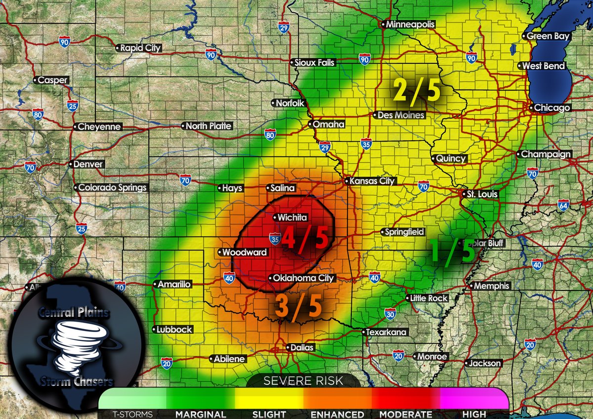

You all know damn well we busting in Kansas tomorrow , don't even deny it 🥳🥳🥳 #wxtwitter
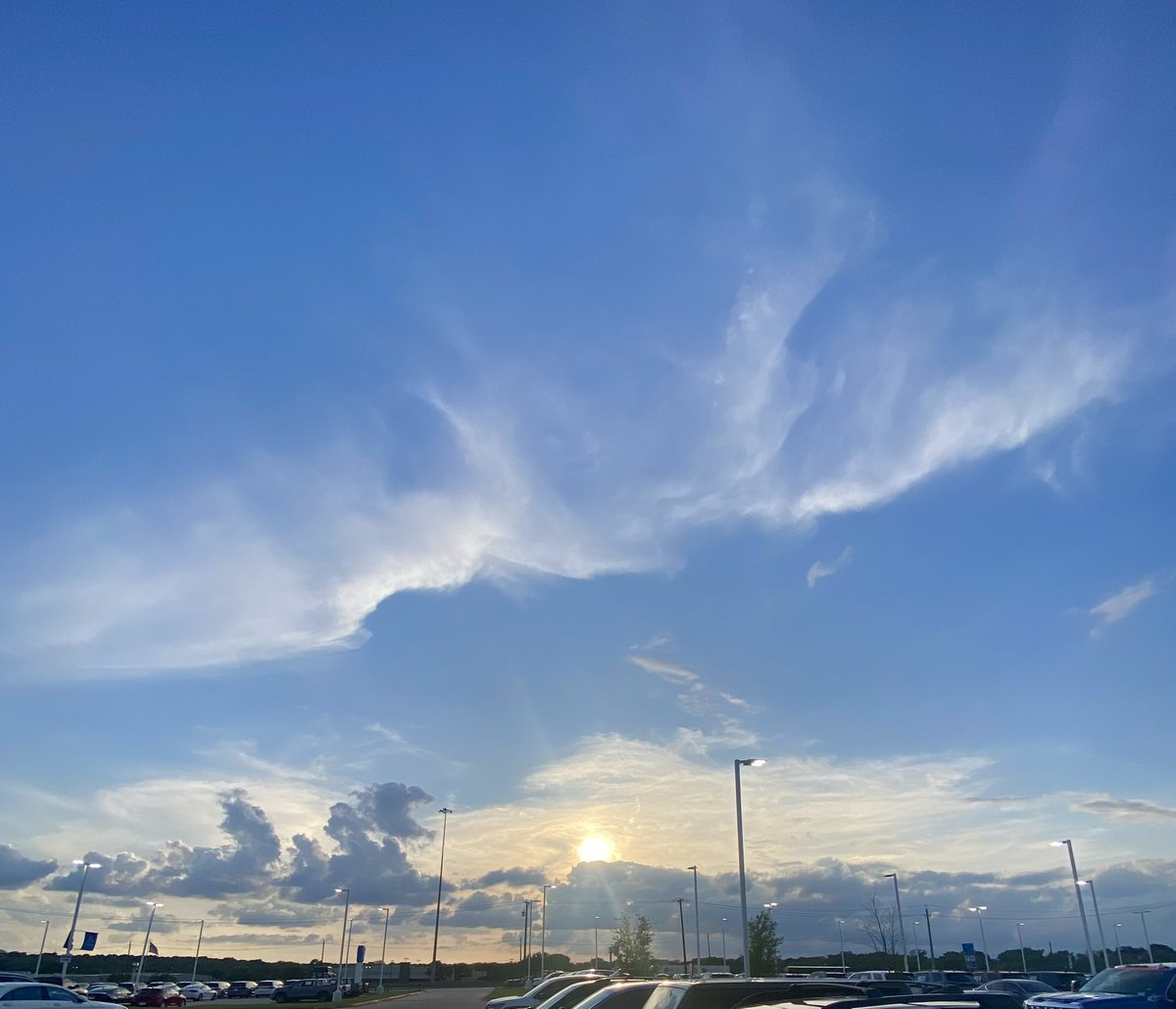
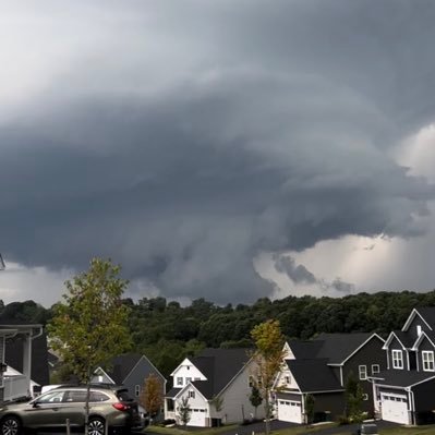
Cool structure for your timeline since no storms fired #wxtwitter


Cool structure for your timeline since no storms fired #wxtwitter https://t.co/zmkp1t5i3s


Things matter Okies! #okwx #wxtwitter @kfor 4.24.24


Chillin in my backyard before severe weather starts up here within the next few days. Beautiful clear skies here in Northeast Oklahoma! #okwx #wxtwitter

Sky boobies for your timeline since no storms fired #wxtwitter

A beautiful evening in Texas #wxtwitter #txwx
Man… I’m being completely honest when I say this, but Saturday has that look to it. We shall see what this looks like tomorrow morning. Definitely could be one of the more significant risks we see for the rest of April. #severewx #wxtwitter


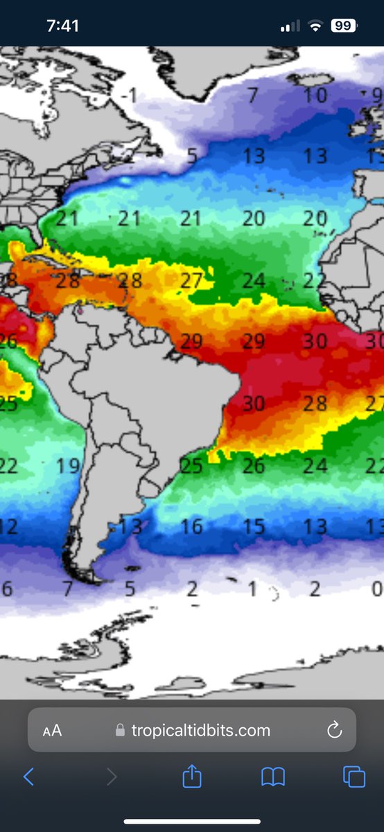
#HCCTWO (1) An unofficial subtropical depression forms in the North Atlantic (2) A system could try to develop just north of #Madagascar early next week #wx #wxtwitter #tropicswx #Cyclones


BIG warmup next week, warmest we've seen this year (and a bit humid). A mostly dry 7 days as well. #PAwx #wxx #wxtwitter


SYSTEM IN THE ATLANTIC HAS BEEN NOTICED BY @NHC_Atlantic, BUT ADDITIONAL INTENSIFICATION IS NOT EXPECTED. #wxtwitter #WednesdayMotivation #Wednesdayvibe

SYSTEM IN THE ATLANTIC HAS BEEN NOTICED BY @NHC_Atlantic, BUT ADDITIONAL INTENSIFICATION IS NOT EXPECTED. #wxtwitter #WednesdayMotivation #Wednesdayvibe

#wxtwitter Wow! That webinar was so cool! Some information addressed during the webinar was that some new additions to the NHC forecast graphics will be used this season as well as some new flood inundation maps that will be available for forecasting come this season!

All that cold against warm. Jets really like to balance those out #wxtwitter

If it wasn’t for the shear, that invest would have a chance with those SST. My goodness! #wxtwitter

Im lowkey kinda scared to see what the D3 outlook looks like tomorrow. #wxtwitter #CSU #twitterwx April 27, 2011.....

WSI poster child for PM Mets around the country this afternoon. And by 6:15PM have the solution! #okwx #wxtwitter #wsi #clickerfest 4.24.24

people of wx ťwitter @peopleofwxX
224 Followers 9 Following I DO NOT HATE WX TWITTER (X) this account Is a joke. if you show up here don't get mad.

weatherbuzzwords @weatherbuzzword
678 Followers 2 Following Raise awareness for those adversely impacted by #weather, edutain #wxtwitter Book: https://t.co/QJV0yZYpOF Creator: https://t.co/V05uceKVJE
WeatherTalk @weather_talk
85K Followers 14K Following All things #weather and #climate. opinions are my own. @weather @weathernation #wxtalk #wxtwitter #wxfront #tornado #hurricane #tropics #snow #blizzard
Oniel castellanos⚡�.. @MeteoZulia
5K Followers 2K Following Meteorología, Astronomía, Ciencias #wxtwitter #RedMeteoZulia #MeteorologiaVenezuela Protección Civil Maracaibo Gestión Integral de Riesgos y Eventos Naturales
Bryce Kintigh @stormchasrbryce
15K Followers 778 Following Meteorologist based in Tornado Alley. Severe weather enthusiast. Live stream at https://t.co/SPWuyN3hTr World traveler. Opinions are my own. #wxtwitter
WxMatteo @WxMatteo
2K Followers 480 Following Chasing my dreams🌪. I only speak FACTS. #wxtwitter @mattdracing @rushtheband lover(18)(The Greatest troll on #wxtwitter)
Artificial Intelligen.. @ai2enviro
2K Followers 123 Following NSF AI Institute for Research on Trustworthy AI in Weather, Climate, and Coastal Oceanography (AI2ES) #ArtificialIntelligence #wxtwitter
Zach_WX @OHWXisweird
2K Followers 810 Following Storm Chaser / high-school weather enthusiast / 17 yrs old / survivor of Ohio’s shit weather 🌩🌨 / @NWSILN skywarn storm spotter / #ohwx #wxtwitter
Jace Craft-Miller �.. @jacecraftmiller
2K Followers 749 Following FORD • ELECTRIC VEHICLES • CLE SPORTS • F1 • NASCAR • WXTWITTER • 🍎 • F-150 LIGHTNING OWNER x2
TWİTTER DİKKAT @cdyrt4rWLYTX7Wx
0 Followers 11 Following
The Perfect Storm �.. @hailpdr
2K Followers 1K Following #Canadian 🇨🇦#stormchaser 🇨🇦 #chasing #storms full time since 2008 Expert On #hail #hailstorms #abstorm #skstorm #onstorm #bcstorm #wxtwitter #spotternetwork
Dalton Fickle @FickleWX
2K Followers 2K Following 19 | OU SoM '27 | Storm chaser | Shitposter | @TeamVortexWX Team Member | #WxTwitter #MOwx #OKwx | 5🌪️
The Artist Formerly K.. @Illisconsin
858 Followers 1K Following Please allow me to introduce myself, I'm a man of wealth and taste.. @MarquetteU '13, PGA, Cubs, Blackhawks, Bears, Bulls, Bayern, Bombogenesis. #WXTwitter
Jennifer Stark @jstar79
7K Followers 5K Following Native Texan based in Saginaw; forecaster & storm chaser/spotter w @LoneStar_WX . senior met student @msstateonline ⛈❤️ #wxtwitter #hailstate #msu
Ben Cathey @bencatheywvlt
667 Followers 167 Following WVLT meteorologist and resident trivia nerd. NWA and CBM sealed. Actively not scrolling #wxtwitter
Corey Elder @coreywxelder
2K Followers 2K Following Mississippi State Operational Meteorology, Great Lakes Storm Chaser, extreme weather #Leafsforever #wethenorth #tothecore #wxtwitter where's my beer #AXA

⚡️CameraCayden⚡.. @CameraCayden
752 Followers 535 Following Amateur Photographer. Canon EOS 4000D📸 Tame Impala enjoyer. #arwx #wxtwitter
Robert LaRoche @PWMwxME
1K Followers 727 Following ECMWF snob - Anomalous/sensational WXtwitter - Models are not a forecast - Spaceweather mentions
Dr. Amy McGovern @profamymcgovern
2K Followers 1K Following Computer Science/Meteorology Professor, Fellow @ametsoc, Director @ai2enviro, mom @wrmf_, #wxtwitter #ArtificialIntelligence @[email protected]
John Wetter @johnwetter
1K Followers 1K Following Weather, climate, and IT guy from Minnesota. A farm kid living in the big city. #wxtwitter #agtwitter #macadmin #FuckCancer
katielock 🌪 @KatieLock7wx
987 Followers 942 Following knower of clouds, chaser of storms, expert at padiddle // half #wxtwitter half #edmtwitter if you like both dm me
Meteorologist - James.. @wx_JamesL
387 Followers 758 Following Consulting Meteorologist @DynamicWxLLC |Wx Forecaster at Grissom ARB|B.S. Meteorology & GIS|USAF Veteran✈ |TWC World's Wildest Weather🎥|#Weather🌩| #WxTwitter|
DENVER’S FUCKING WE.. @DENVERSWEATHER
11K Followers 6K Following The foulest weather report this side of shittucky. Chaotic Good. Blocked by 9News & Boulder's NWS (♡) cuz I'm dirty. #COwx #wxtwitter #deathmetal ☠☠☠☠☠☠
⛈️🌪Bethany Rob.. @brobinsonwx
1K Followers 2K Following I love storms⛈️ and all forms of weather 🌤🌧❄️ It is on my bucket list to see a tornado and aurora in person🌪🌈 #wx #arwx #wxtwitter #photography
Kristy Sharkey @kristy_sharkey
452 Followers 438 Following Just here for #wxtwitter. I’m a Seattle-area weather nerd and photographer. I design websites and apps for a living.
Seth Jackson @sethjackson92
776 Followers 1K Following Texas State Alumni. Storm Chaser. DoorDash Driver. Stock Market Enthusiast. Geography Nerd. #wxtwitter follow me and I’ll follow back.
Amanda Wagner @WagnersWeather
396 Followers 400 Following Graduate Research Assistant @VillanovaU Meteorologist & GIS Profesh Hokie Alumna Coffee Enthusiast Outdoor Adventurer #wxtwitter only ⚡
Sophia Adams (she/her.. @sophiaelorene
391 Followers 642 Following meteorologist @NWSBoise | pathways @NWSGreatFalls | M.S. @PlymouthState| ETA 2019 @FulbrightMY | enjoys dogs, #wxtwitter, and justice. all opinions are mine
The Weather On 𝕏 @WeatherOnX
373 Followers 971 Following ☈ The official 𝕏 account for The Weather on 𝕏, but not to be confused with 𝕏, which is unaffiliated. #WeatherOnX #WXonX #WxX #WxTwitter | More To Come Later
Connor Moriarty @cmoriarty79
254 Followers 230 Following The least famous Connor on wxtwitter. BS Aerospace Engineering ‘23 | Decent programmer | Somewhat competent chase driver (🌪: 10) @junefirstwx
Kevin Huyck (he/him) .. @WeatherHike
367 Followers 940 Following @NWSDuluth Met | Wrong less than 50% | #weather #wxtwitter #nuclear #autism #MentalHealth #AuDHD (the “gold” standard😅) | My views | #ActuallyAutistic | #ADHD
Ryan Wright @ryanwrightphoto
523 Followers 721 Following #wxtwitter, #Nuggets, #Rockies, landscape photographer and part-time storm chaser Prints here ➡️ https://t.co/C4rZl2DbOL
Obi-Bon Kenobi @baroclinity
199 Followers 626 Following Upper Air. Meteorologist. LGBTQ+STEM. They/Them. Tweets/opinions are my own. #wxtwitter #actuallyautistic