Encuarentenado @oneGeoDataNerd
Joined April 2020-
Tweets10
-
Followers1
-
Following81
-
Likes44
#Leafmap v0.18.0 has been released. It supports searching and visualizing #OpenAerialMap imagery interactively. Accessing 12K+ openly licensed satellite and drone imagery for free 👇 Notebook: leafmap.org/notebooks/68_o… @hotosm #geospatial #openaccess #dataviz #gischat

#Wildfires in #Chile have left devastating scars on landscapes, burning over 430,000 hectares of forest. 🔥 The red zones on the image below are the burnt areas over Chile on Feb 28. Our new Burnt Area feature helps assess the damage, track recovery, & mitigate future risks. 🌎🛰️


Animating the Mercator projection to the true size of each country in relation to all the others. Focusing on a single country helps to see effect best. #dataviz #maps #GIS #projectionmapping #mapping
We keep monitoring the devastating #wildfires in #Chile.🔥 With our new Burnt Area feature, available on our Wildfire Solution platform, we can now complete daily damage estimations of the affected areas. This helps to track and analyze the evolution of the fires more precisely.


These two #oilspill 25km South of #Bachaquero #MaracaiboLake #Venezuela @PDVSA have been spilling crude oil since August 2022. They are responsible for the permanent slick, sometimes long as 100km, that covers almost all of the East coast of the lake.


Wildfires 🔥 continue to ravage #Chile 🇨🇱 More than 350,000 hectares have been burnt in less than 10 days ⬇️The burn scars are visible in this animation created using #Copernicus #Sentinel3 🇪🇺🛰️ imagery acquired between 2 (before the crisis) and 11 February (yesterday)

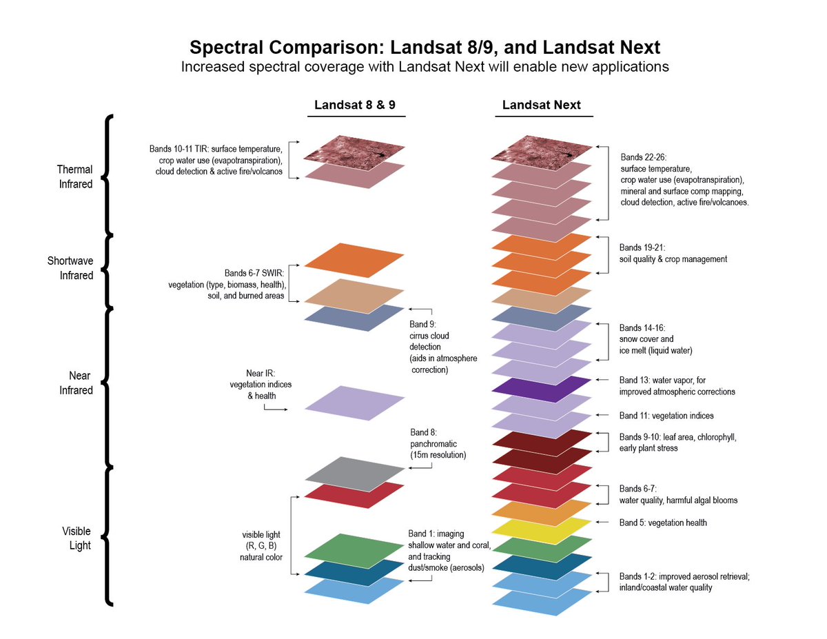
At Landsat Science Team meeting, hosted by Justin Huntington @watermapper at the Desert Research Institute @DRIScience. Right now learning about #Landsat Next - WOW! 2030 launch, 3 satellite constellation. Superspectral, 10 m 🤯 landsat.gsfc.nasa.gov/satellites/lan…

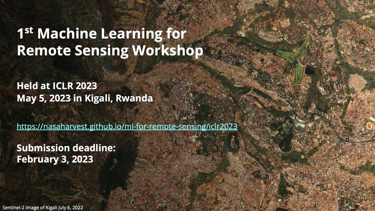
We are accepting submissions for the 1st Machine Learning for Remote Sensing Workshop at @iclr_conf 2023 in Kigali, Rwanda. Submission deadline is Feb 3, 2023. nasaharvest.github.io/ml-for-remote-… Hope to see you there!

Simone Conradi @S_Conradi
10K Followers 2K Following Theoretical Physics Ph.D., Computer Science Teacher. Author of “Intelligenza Artificiale” Zanichelli 2022. I draw using mathematics and Python.
Rafaela Tiengo 🇧�... @RafaelaTiengo_
2K Followers 826 Following Remote Sensing • Earth Observation • Geospatial news 🌍🛰️ (She/her) | ✉️ [email protected]
Luna Geospatial, Inc. @LunaGeospatial
1K Followers 956 Following Open source GIS consulting, training, support, software development, and servers-as-a-service. We are pros with #QGIS #PostGIS #Geoserver and more.
Geoawesome @geoawesome_dgtl
25K Followers 6K Following Open and inclusive community platform for geospatial experts and enthusiasts. Building bridges across sectors and industries. All things GEO awesome 🌎 🛰🗺🚀
USGS Data Science @USGS_DataSci
10K Followers 173 Following Featuring @USGS #dataScience and #DataViz
Plotly @plotlygraphs
42K Followers 8K Following Put data & AI into action by creating scalable, interactive data apps for your business with Dash.
Geo_Spatialist @geo_spatialist
41K Followers 74 Following IG/Twitter/Threads @geo_spatialist Bluesky @geospatialist.bsky.social
GeoHipster @geohipster
8K Followers 916 Following Mapping the world, one organic vertex at a time. Get your 2023 calendar now at https://t.co/BtCL7MLCnP
Geospatial Python @geospatial_py
4K Followers 0 Following A Twitter bot that automatically retweets everything about #geospatial #python stuff. #geopython #GIS #RemoteSensing #Jupyter.
Whitebox Geospatial @whiteboxgeo
7K Followers 2K Following Innovative geospatial software solutions built on open-source. #lidar #TerrainAnalysis #geospatial #GIS #remotesensing #geomorphometry #geomatics
gdal org @GdalOrg
4K Followers 6 Following No longer here. Find us at @[email protected] GDAL is a translator library for raster and vector geospatial data formats.
Esri @Esri
190K Followers 66K Following Esri builds #ArcGIS, the leading location intelligence and spatial analytics software for mapping, 3D GIS, imagery, and geospatial app development.
Annamaria Luongo @annamaria_84
5K Followers 2K Following Earth observer. Managing Partner of @ALSOSpace_. #dataviz @CopernicusEU, @CopernicusEMS, @CMEMS_EU. Born at 345ppm. #NoPlanetB. Views are my own. #SciComm
Group on Earth Observ... @GEOSEC2025
19K Followers 4K Following 🛰️ Translating Earth Intelligence with global collaboration. ℹ️ https://t.co/I3zKOfaBls #EarthIntelligenceForAll #MapEcosystems
USGS Landsat @USGSLandsat
37K Followers 219 Following The Landsat Program is a series of Earth-observing satellites, co-managed by @USGS and @NASA. Delivering decades of Earth imagery, since 1972. 📡🛰️
Gabriel Peyré @gabrielpeyre
102K Followers 453 Following @CNRS researcher at @ENS_ULM. One tweet a day on computational mathematics.
Qiusheng Wu @giswqs
46K Followers 4K Following Associate Professor @UTKGeography | @Amazon Scholar | Talk about #opensource #geospatial #dataviz #EarthEngine
NC State Center for G... @NCSUgeospatial
2K Followers 331 Following Everything is spatial and location matters at the Center for Geospatial Analytics, an interdisciplinary teaching and research center at NC State University.
Geospatial World @geospatialworld
33K Followers 3K Following Your trusted knowledge source for all things geospatial. We delve into tech convergence and pivot to Industry 4.0 via Digital Transformation and Sustainability
Evelyn | @evelynuuema... @evelynuuemaa
2K Followers 434 Following Geographer and Professor in Geoinformatics @unitartu, Head of the @LGeoinformatics Lab. Geospatial and open data enthusiast, foodie and coffee junkie :-)
Sara Venturini @la_Venturini
2K Followers 2K Following Earth observer. À la carte diplomat. Chief of Member Services at the GEO Secretariat @GEOSEC2025 hosted by @WMO. Also Dr.
Enabling Crop Analyti... @ECAAS_AGData
237 Followers 227 Following Working to unlock the promise of satellite-based data and analytics for smallholder farmers.
Radiant Earth @OurRadiantEarth
8K Followers 1K Following Increasing shared understanding of our world through community-led initiatives that make data easier to access and use.
Robin Cole @robmarkcole
11K Followers 4K Following Tackling the worlds toughest challenges with AI & ML applied to satellite & aerial imagery https://t.co/QmbOWgdfAZ

GIS and Science @GISandScience
30K Followers 10K Following Sharing issues and applications of geospatial technology for scientific research and understanding. Tweets by the @Esri Science Team with @deepseadawn

Open Geospatial: OGC @opengeospatial
27K Followers 230 Following OGC’s member-community of experts makes location data Findable, Accessible Interoperable, and Reusable (FAIR) through #innovation #collaboration and #standards
FOSS4G 2024 | https:/... @foss4g
18K Followers 592 Following The world’s largest gathering of open source geospatial users, developers, and researchers. FOSS4G | https://t.co/wtkKL1RgOW
Christopher Beddow @cbed32
2K Followers 2K Following #openstreetmap #mapillary #gis #rapid 😎 Map Building for #AR @ Meta 🗺️ 📍Montana 🇺🇲 ➡️ Schwyz 🇨🇭 🌎 Voyager, language learner, writer, mapmaker, skier ⛷️
Adriano Nobile @j_p_joule
601 Followers 100 Following I am a research scientist in KAUST. I process radar images to study ground deformation. I like to see colorful fringes on my screen.
Google Developer Grou... @GDGPune
5K Followers 68 Following GDG Pune is a vibrant community of passionate developers. Join us to learn more about latest developments in technology & to network with smart people in tech.
Sisters of SAR @SistersofSAR
10K Followers 4K Following A passion for all things #SAR | #WomeninSAR | @eoscenefrom | We 💜@LadiesofLandsat & @DamesofDrones| Tweets by @LDR1, @SAR_ahBanks, @Go__Pika & @ant_dasgupta |
Satellogic @Satellogic
21K Followers 510 Following Vertically integrated EO satellite and geospatial data company ($SATL) Join our newsletter for exclusive updates: https://t.co/UDhpsW0M7Z
Hydrology Next @HydrologyNext
12K Followers 2K Following We exploit satellite🛰️and ground📡 observations for #hydrology☔#flood🏞️#drought🏜️#landslide⛰️#irrigation🌱#precipitation🌧️#streamflow🌊+climate change


IEEE Geoscience and R... @IEEE_GRSS
7K Followers 525 Following The official X account for IEEE Geoscience and Remote Sensing Society.
RUS-Copernicus @RUS_Copernicus
4K Followers 519 Following Research and User Support for #Sentinel Core Products: a new expert service for #SentinelUsers funded by the #EC, managed by #ESA, operated by CSSI & partners
QGIS @qgis
64K Followers 63 Following Official account of QGIS - the user friendly Open Source Geographic Information System
OpenStreetMap @openstreetmap
83K Followers 219 Following OpenStreetMap is the free editable map of the whole world. It is made by people like you! @[email protected]
Mapbox @Mapbox
75K Followers 2K Following Mapbox powers navigation for people, packages, and vehicles everywhere. Register for BUILD with Mapbox.
CARTO @CARTO
31K Followers 6K Following Spatial analytics built for the cloud. Sign up for your free 2-week trial: https://t.co/K3o3gkbN5l
NASA Earth @NASAEarth
3.7M Followers 85 Following NASA’s favorite (habitable) planet. 🌎💚 Studying Earth from ground to orbit. Verification: https://t.co/86cw0iKou6
CultureVolcan @CultureVolcan
5K Followers 96 Following @[email protected];Géologue (spé #volcanologie) je décortique les #éruptions #volcaniques depuis 2003(#médiation #Science communicator);Né/born 332ppm
Copernicus Land Monit... @CopernicusLand
12K Followers 759 Following Copernicus is the European Union's Earth Observation programme. CopernicusLand is one of six thematic services that deliver free and open geospatial products
Fundación Caribe Sur @CaribeSurOrg
7K Followers 1K Following Promoción de la conservación del patrimonio ambiental, cultural y paisajístico del Caribe Sur, desde 2004 📧[email protected]
EO OPEN SCIENCE @EO_OPEN_SCIENCE
15K Followers 827 Following European Space Agency account for the #EarthObservation (EO) #OpenScience user community. Exploring challenges & opportunities created by revolutions in #EO.
European Space Agency @esa
1.8M Followers 1K Following #50YearsOfESA: we're the European Space Agency, keeping you posted on European space activities. Please see our Privacy Notice: https://t.co/UkkEqaJOwd
Earth Observation Lab @HumboldtEOLab
9K Followers 2K Following 🚨 Left X for Bluesky: Follow for open, fact-based Earth observation research. 👉 https://t.co/G27aCGAkReTrends for United States
You might like