
-
Tweets47
-
Followers81
-
Following80
-
Likes212
After a long break, I just published 'Remote sensing for Smart City Modelling' @808Computing Here's a link: medium.com/nebula-researc…
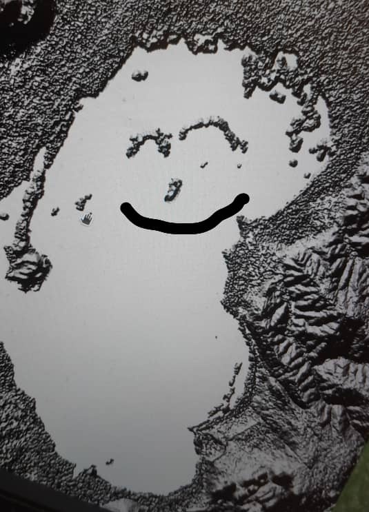
I am excited to talk about mapping lake chilwa using synthetic aperture radar SAR and unsupervised machine learning at the 5th indabax

#452 Top Quart (async Flask) Extensions The latest episode with Philip Jones and @mkennedy is out. Enjoy! #python talkpython.fm/episodes/show/…
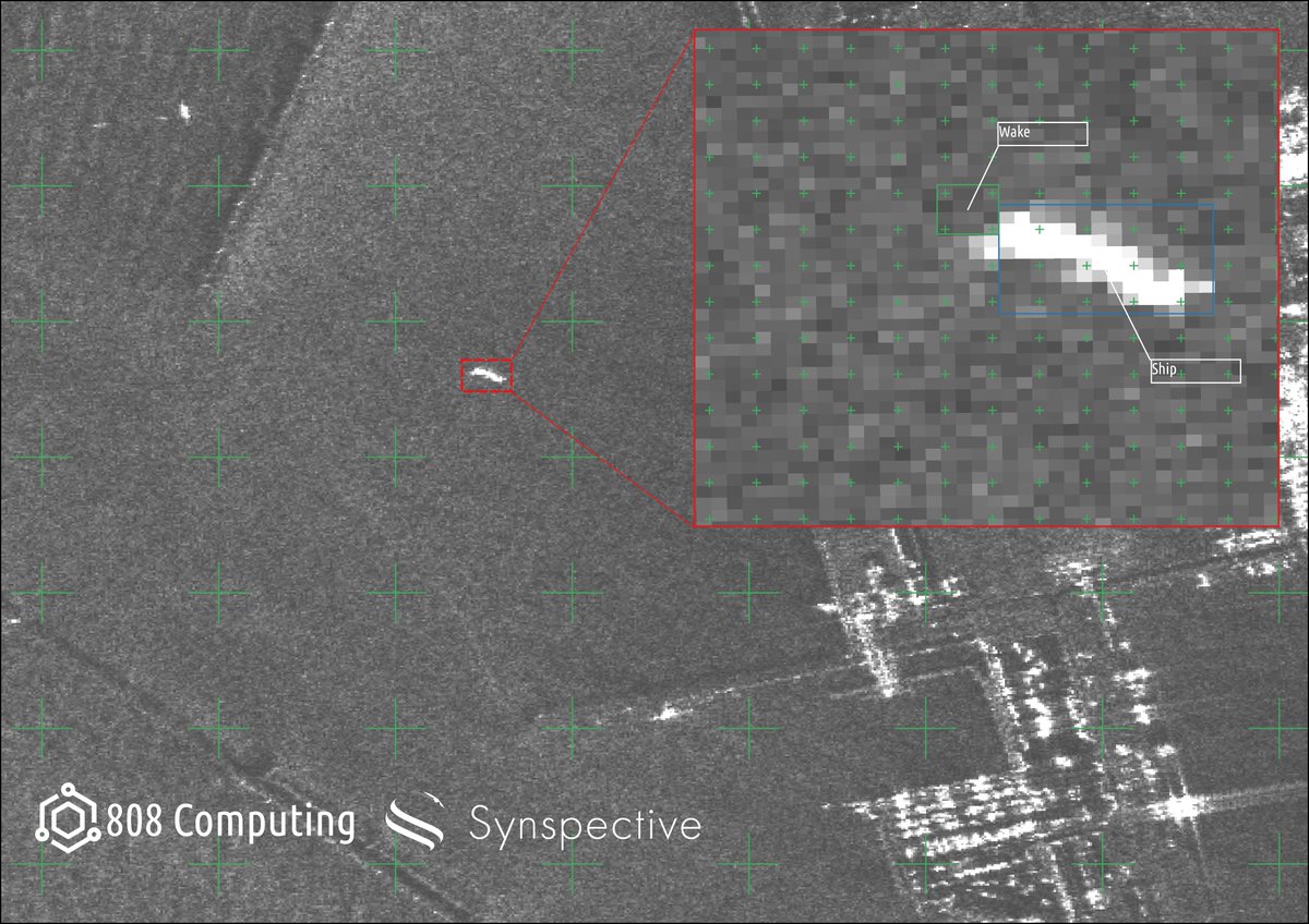
Synthetic Aperture Radar image of the coast of Hachiro Lagoon Japan. Taken by @synspective Strix Satellite & mapped by @808Computing The inset shows the segmented ship and trailing wake which can help infer ship direction Links: synspective.com/gallery/hachir… 808computing.org
Biological Diversity, Nested Hierarchies and Parismony By Aaron Mboma medium.com/nebula-researc…

A Koordinates data portal adapts to your workflows. The dynamic UI lets you focus on the browser, map, table or a single feature. Explore today at bit.ly/3s9TRs4 #Geospatial #GIS #Data

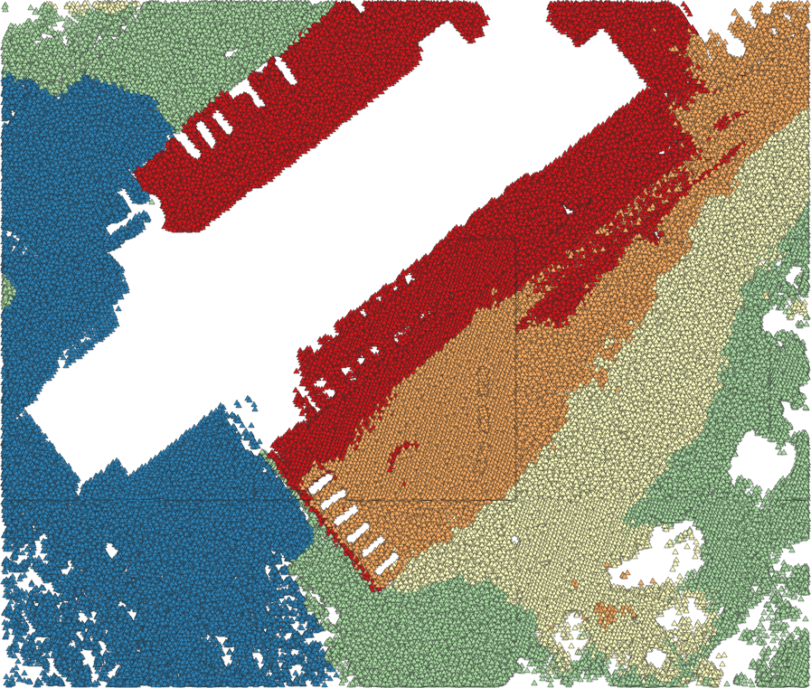
a lil sneak peak... rendering 3.2 million points from GeoPandas in 1 second 🚀

Cloud optimized Synthetic Aperture Radar image of Tanna Island by @umbraspace …og.s3-website.us-west-2.amazonaws.com/?prefix=sar-da…

It all still seems surreal to me; attending and speaking at the @geoworldmedia conference, the invaluable knowledge gained listening to industry leaders speak, and the connections I have made. I feel super proud of myself and @TheGeoSpatialH1 #gischat #geospatial

Thanks to those who supported our crowdfunding, we have now introduced the native point cloud processing in @qgis: lutraconsulting.co.uk/blog/2023/05/3… #lidar #3d
With our latest work and introduction of point cloud processing to @qgis, you can export your LIDAR data to @shapefiIe (please don't).
It builds upon #ipywidgets and supports bidirectional communication between the frontend and backend. No other Python-based web app frameworks has native support for ipywidgets except Solara. The closest one would be Voila, but Solara is much better than Voila.
#Leafmap v0.21.0 is out. It now supports @solara_dev. Developing interactive web apps with pure Python with automatic deployment on @huggingface. Try it out 👇 Web app: giswqs-solara-geospatial.hf.space/leafmap GitHub: github.com/opengeos/solar… @maartenbreddels #python #geospatial #dataviz
Congratulations to @hwtnv, one of the first recipients of Cesium Ecosystem Grants, a $1M fund to advance the #3D #geospatial ecosystem. Learn more about this group of recipients and apply: bit.ly/3ObrmmD
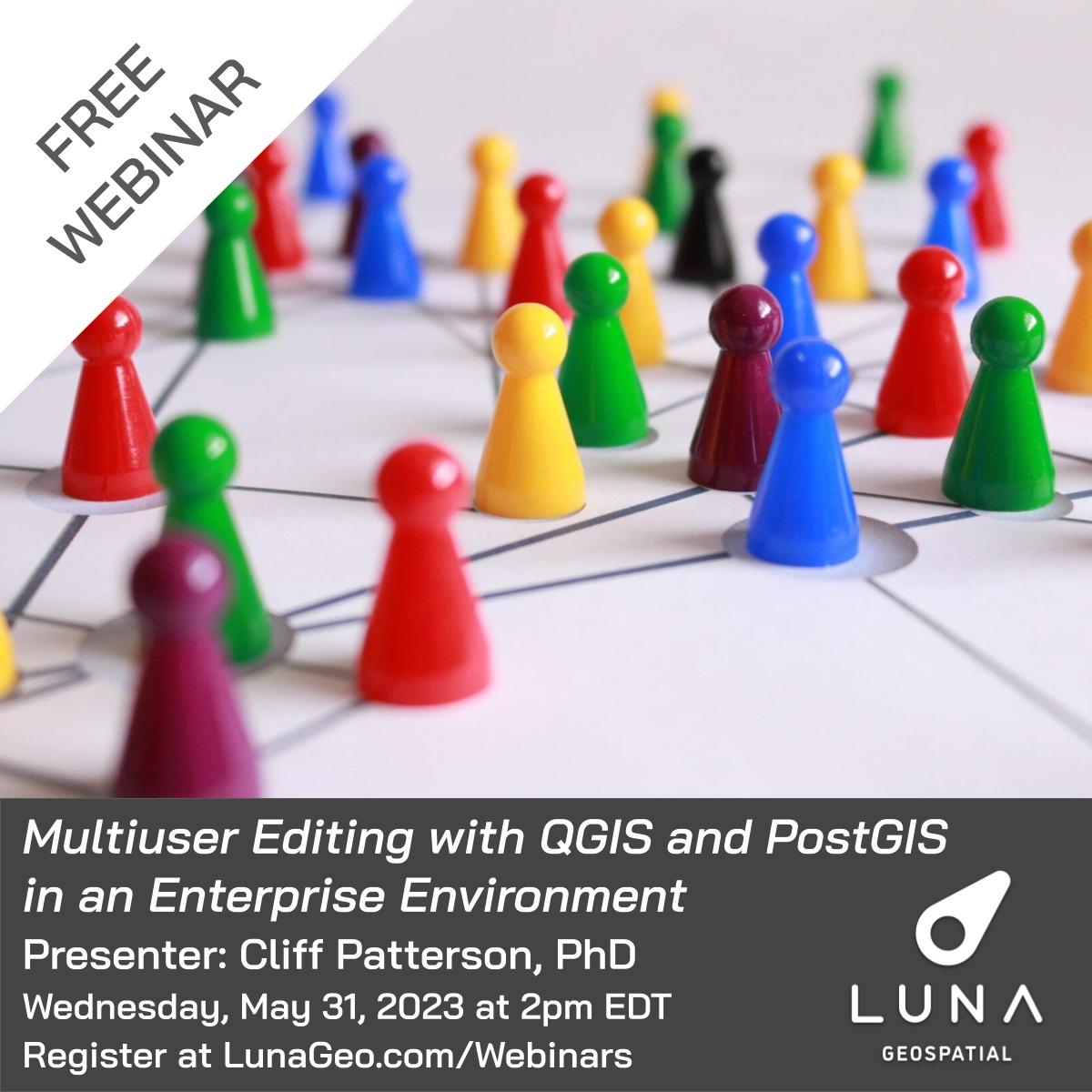
It's Webinar Week! Multiuser Editing with QGIS and PostGIS in an Enterprise Environment presented by Cliff Patterson @cliffpat is this Wednesday, May 31 at 2pm EDT. Registration is still open, sign up now at lunageo.com/webinar/multiu…
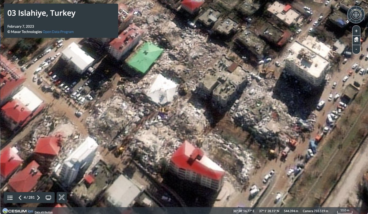
We are working with @umbraspace & @SkyfiApp to help locate the missing climbers on Mt. Everest. We're currently differentiating manmade objects from the snow & rocks to detect human activity. We could use your help to find the missing climbers!

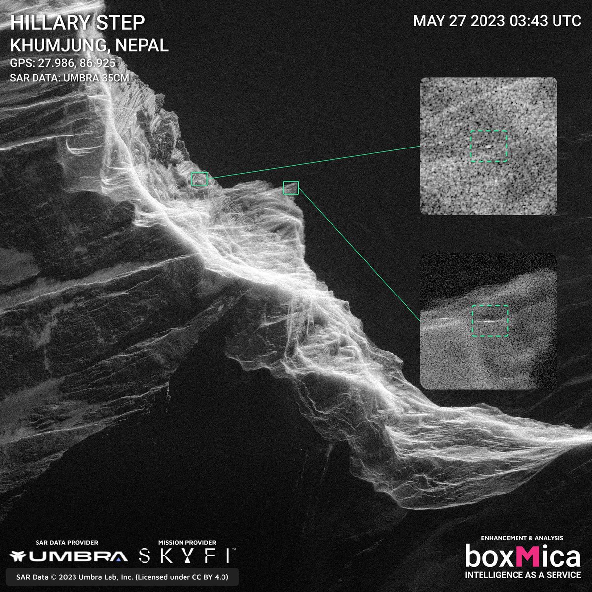

We are working with @umbraspace & @SkyfiApp to help locate the missing climbers on Mt. Everest. We're currently differentiating manmade objects from the snow & rocks to detect human activity. We could use your help to find the missing climbers! https://t.co/nBPZMkrPpE


The completely new mobile apps for Talk Python Training courses are now out on all the mobile platforms. Here's the story of how they are built with #flutter and #python. Download them for free and take some of the free courses included cc @mkennedy mkennedy.codes/posts/mobile-a…
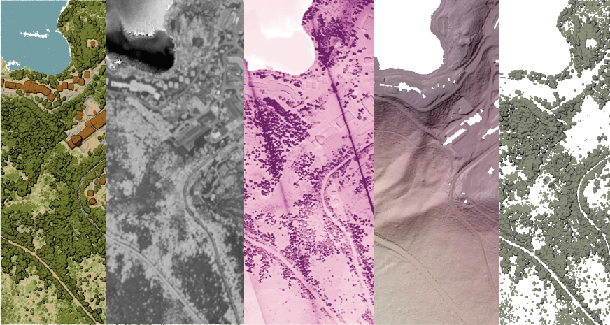
GLanCE has grown! The Global #LandCover Mapping and Estimation product now covers Europe. This product includes seven land classes or a greenness index as shown in this image over Venice, Italy. Visit NASA’s #LPDAAC to learn more: bit.ly/3I8cjXB


Godfrey Msukwa @Godmsukwa
13 Followers 318 Following


Margin of Error @Ju11am
214 Followers 354 Following Lab Chief @ RiskLab FIU PhD Student in Earth Systems Science | Models & Morals
Kachere AI @KachereAI
107 Followers 541 Following Your digital lawyer here to help you with all things Malawian laws and regulations. How can I help?
AlvaroAnguix @AlvaroAnguix
46K Followers 6K Following gvSIG Association. General Manager. Professional Open Source GIS. GIS consultants. Geo services. gvSIG Suite. Be free. Eppur si muo. e-mail: [email protected]

Mari @Mari64630538333
263 Followers 3K Following
Sharon @sharonspencer37
257 Followers 3K Following
Laura @mustard_laura10
263 Followers 3K Following
Mable @whitemable96
356 Followers 3K Following
Susan @susantellier90
290 Followers 3K Following

Alberta @alberta98pawlak
270 Followers 3K Following
Mary @p_mary26
274 Followers 3K Following
Courtney @courtney_tacket
266 Followers 3K Following
Gintech Geoservices �... @GintechG
930 Followers 771 Following We are professional providers of Land Surveying | Engineering Survey | GIS | Remote Sensing | Topographical Mapping. Call or WhatsApp 0795784361
Lisette @l_moh78
244 Followers 3K Following
Michelle @z_michelle81
257 Followers 3K Following
Toni @tonigraham41
346 Followers 3K Following
Marilyn @marilyn42rodman
249 Followers 3K Following

Shobhits @FluvialShobhit
398 Followers 2K Following Research Scholar @ IIT Kanpur | Fluvial geomorphology | Exploring Geospatial, drone tech, ML in River science research | J🌍💡
quub @quubspace
337 Followers 802 Following We build micro-satellites that take the pulse of planet Earth. 🌎
Bakili Muluzi FAN Acc... @GoateeLivin
514 Followers 745 Following Just another shitpost account... Supervillain • Alchemist • Chick magnet • I make beats sometimes •
Theresa @houcktheresa92
380 Followers 3K Following
Aaron Mboma @mboma_aaron
388 Followers 376 Following Zoologist: Butterfly Systematics, Biodiversity, Molecular Phylogenetics, Speciation, Evolutionary Genetics. ❤️ Cats. Malawian.
Olamiposi Caleb Fagun... @Paragon41
2K Followers 2K Following Data Analyst @hotosm | ESG Intern @wylde_center | GIS Analyst | OSM | Climate Analyst | FOSS4G | Remote Sensing Expert | Cartographer | Researcher | Space 🚀

Wahome🗺🛰 @ItsWahome
10K Followers 10K Following |GIS |Remote Sensing |Cartography |Conservation |Nature Based Solutions |Data
Geozeerah GIS & Spati... @MusaMuhali
1K Followers 3K Following GIS and Remote Sensing Expert | UAV Pilot | Plantation establishment specialist.
Bukhosi Khumalo @bn_khumalo
366 Followers 1K Following Lecturer | I love GIS| Msc Cartography and Geoinformatics https://t.co/2dSv33qDlS
NORTH51 Conference @N51Conference
236 Followers 306 Following We have big ideas about the future of geospatial and know you do too. Attending is more than just that, it’s about sharing and challenging the status quo.
BoxMica @boxMica
1K Followers 464 Following Intelligence as a Service. Get Actionable Intelligence, With Rapidly Delivered Briefings, For Persistent Geospatial Monitoring Missions. 🇺🇸
GeoDAJ Consultants @GeoDAJ_Ltd
1K Followers 1K Following GIS|| Remote Sensing|| Land Surveying|| Cartography|| Web Mapping|| Environmental Impact Assessment|| Building and Construction||

fun Razor_blade @Chris69329277
86 Followers 281 Following
Me @PrieThomson
184 Followers 234 Following
Sibongile @SiboKhozi
12 Followers 32 Following
Tabo🤎 @20Tawongah
928 Followers 464 Following
UNCLE_T @TONEY_GUYY
261 Followers 469 Following I don't take advice from niggas who don't even know how much it takes to get to where I am today🚩😑 IG : https://t.co/mwhiTtdAWq

milcah @milcah66432684
21 Followers 83 Following
Lusungu Mwambeye @MissLue97
49 Followers 136 Following
tafadzwa rusike @Tafnats_rusky87
38 Followers 76 Following GOD fearing kid who is still on a journey to success.
Chisasiko🤓 @lumbani_makumbi
208 Followers 466 Following Full-stack dev 💻 | AI enthusiast 🤖 | Automation nerd ⚙️ | Building smarter solutions 🚀
BuyLoco_Online @BuyLoco_Online
302 Followers 776 Following Your customer/seller isnt on your timeline. But they're surely somewhere. Lets show you where! Coming soon... Email :[email protected]
Kande Dried Fruits @KandeDryFruits
13 Followers 27 Following Organic dried fruits +265880125924 [email protected]
AlvaroAnguix @AlvaroAnguix
46K Followers 6K Following gvSIG Association. General Manager. Professional Open Source GIS. GIS consultants. Geo services. gvSIG Suite. Be free. Eppur si muo. e-mail: [email protected]
Gintech Geoservices �... @GintechG
930 Followers 771 Following We are professional providers of Land Surveying | Engineering Survey | GIS | Remote Sensing | Topographical Mapping. Call or WhatsApp 0795784361
Bakili Muluzi FAN Acc... @GoateeLivin
514 Followers 745 Following Just another shitpost account... Supervillain • Alchemist • Chick magnet • I make beats sometimes •
quub @quubspace
337 Followers 802 Following We build micro-satellites that take the pulse of planet Earth. 🌎
Olamiposi Caleb Fagun... @Paragon41
2K Followers 2K Following Data Analyst @hotosm | ESG Intern @wylde_center | GIS Analyst | OSM | Climate Analyst | FOSS4G | Remote Sensing Expert | Cartographer | Researcher | Space 🚀
Aaron Mboma @mboma_aaron
388 Followers 376 Following Zoologist: Butterfly Systematics, Biodiversity, Molecular Phylogenetics, Speciation, Evolutionary Genetics. ❤️ Cats. Malawian.
Bukhosi Khumalo @bn_khumalo
366 Followers 1K Following Lecturer | I love GIS| Msc Cartography and Geoinformatics https://t.co/2dSv33qDlS
FastAPI @FastAPI
39K Followers 1 Following FastAPI framework, high performance, easy to learn, fast to code, ready for production. 🚀 Web APIs with Python type hints. 🐍 By @tiangolo 🤓
Sebastián Ramírez @tiangolo
79K Followers 327 Following Creator of @FastAPI, Typer, SQLModel, Asyncer, etc. 🚀 From 🇨🇴 in 🇩🇪 . Open Source, APIs, and tools for data/ML. 🤖
SpatioTemporal Asset ... @STACspec
2K Followers 15 Following Enabling online search and discovery of geospatial assets.
𝙼𝚊𝚝𝚝𝚑�... @GeoSkeptic
2K Followers 860 Following remote sensing, foss4g, and scientific skepticism @element84. Hieronymus Bosch fan.
Chris Holmes @opencholmes
4K Followers 144 Following Working towards Cloud-Native Geospatial, through involvement in @GeoParquet, @planet, @STACSpec, @cogeotiff, @cloudnativegeo & @source_coop.
Open Geospatial: OGC @opengeospatial
27K Followers 230 Following OGC’s member-community of experts makes location data Findable, Accessible Interoperable, and Reusable (FAIR) through #innovation #collaboration and #standards
Radiant Earth @OurRadiantEarth
8K Followers 1K Following Increasing shared understanding of our world through community-led initiatives that make data easier to access and use.
Geo_Spatialist @geo_spatialist
41K Followers 74 Following IG/Twitter/Threads @geo_spatialist Bluesky @geospatialist.bsky.social
Blender 🔶 @Blender
360K Followers 4 Following Official account of the Free and Open Source 3D creation suite. Blender is free to use for any purpose, forever. 🧡 #b3d
Heresh Fattahi @HereshF
1K Followers 434 Following SAR and InSAR algorithms enthusiast and engineer at @NASAJPL. Looking for signal and making sense of noise. Leading NASA ISRO SAR (NISAR) science algorithms.Guido van Rossum @gvanrossum
288K Followers 480 Following Python's BDFL-emeritus, Distinguished Engineer at Microsoft, Computer History Fellow, fully vaccinated. Opinions are my own. He/him.


Cesium @CesiumJS
11K Followers 9K Following The Platform for 3D Geospatial. Tile, visualize, contextualize, and analyze your 3D data. #3DTiles #WebGL
Paul Ramsey @pwramsey
7K Followers 232 Following Please find me at @[email protected] @pwramsey.bsky.social
Nadine Alameh (also @... @nadinesa
2K Followers 1K Following Executive Director | former CEO @opengeospatial| Alum @MIT | Geo Innovation, AI & Partnerships for Impact | Instructor @Jazzercise | Single mom
Satellogic @Satellogic
21K Followers 510 Following Vertically integrated EO satellite and geospatial data company ($SATL) Join our newsletter for exclusive updates: https://t.co/UDhpsW0M7Z
Emiliano Kargieman @earlkman
14K Followers 3K Following CEO @Satellogic. I'm here to see the fnords.
Felt @felt
11K Followers 140 Following A better way to work with maps. @Bluesky: https://t.co/TJfGQsZH6l
OpenCage Geocoder �... @OpenCage
3K Followers 519 Following We're no longer actively using this account. • Mastodon: https://t.co/XZUJuGm2A3 • API docs: https://t.co/5uR68ZIJ0d
Franz J Meyer @SARevangelist
6K Followers 1K Following Professor for Radar Remote Sensing, UAF & Chief Scientist of the NASA Alaska Satellite Facility DAAC. Spreading the word on the amazing capabilities of SAR.
MapScaping @MapScaping
37K Followers 115 Following The MapScaping Podcast is a #podcast for the #geospatial community. Just search for "MapScaping" Wherever you get your podcasts!
Robin Cole @robmarkcole
11K Followers 4K Following Tackling the worlds toughest challenges with AI & ML applied to satellite & aerial imagery https://t.co/QmbOWgdfAZ
Qiusheng Wu @giswqs
46K Followers 4K Following Associate Professor @UTKGeography | @Amazon Scholar | Talk about #opensource #geospatial #dataviz #EarthEngine
Joe Morrison @mouthofmorrison
29K Followers 2K Following “Controversial industry figure” and General Manager of Remote Sensing at @umbraspace. We operate a private constellation of radar spy satellites.
NORTH51 Conference @N51Conference
236 Followers 306 Following We have big ideas about the future of geospatial and know you do too. Attending is more than just that, it’s about sharing and challenging the status quo.
Max Lenormand @MaxLenormand
5K Followers 812 Following Dev Advocate at @Fused_io Interested in maps, satellite images & the people building all of it Youtube: https://t.co/k2JTlXKSp6 Podcast : @MindsBehindMaps
NV5 Geospatial @NV5Geospatial
6K Followers 4K Following Formerly Quantum Spatial, we are the geospatial pioneer: Delivering data + analytics, providing geospatial insights to government and corporate organizations.
OpenAerialMap @OpenAerialMap
1K Followers 193 Following Set of tools by @hotosm for searching, sharing, and using openly licensed satellite and unmanned aerial vehicle (UAV) imagery
CARTO @CARTO
31K Followers 6K Following Spatial analytics built for the cloud. Sign up for your free 2-week trial: https://t.co/K3o3gkbN5l
GeoNadir @GeoNadirAu
2K Followers 2K Following We make drone mapping even better. #remotesensing #geospatial #Earthobservation #dronesforgood
gdal org @GdalOrg
4K Followers 6 Following No longer here. Find us at @[email protected] GDAL is a translator library for raster and vector geospatial data formats.

SpaceX @SpaceX
39.9M Followers 120 Following SpaceX designs, manufactures and launches the world’s most advanced rockets and spacecraft
SkyFi® @SkyfiApp
14K Followers 329 Following The World's Earth Intelligence Platform 🌎 Enter the app 📱& 🖥️. Get answers.
Luke Fischer @FischerLukeM
2K Followers 1K Following CEO and Co-Founder of SkyFi…and I like my French bulldogs #austin4america
Dr Robbi Bishop-Taylo... @SatelliteSci
8K Followers 5K Following Posting at 🦋. Earth Observation Scientist at @GeoscienceAus. Using satellites 🛰️ to study the earth 🌍 through space and time
BoxMica @boxMica
1K Followers 464 Following Intelligence as a Service. Get Actionable Intelligence, With Rapidly Delivered Briefings, For Persistent Geospatial Monitoring Missions. 🇺🇸
NASAEarthdata @NASAEarthData
40K Followers 382 Following This account is inactive. Follow @NASAEarth and subscribe to our newsletter for data releases and other Earthdata news: https://t.co/pOtbqt9QpYTrends for United States
You might like

