CHC Navigation @CHCNavigation
Founded in 2003, CHC Navigation (CHCNAV) is a publicly-listed company creating Innovative GNSS Navigation and Positioning Solutions. chcnav.com Shanghai Joined October 2015-
Tweets534
-
Followers791
-
Following86
-
Likes76
⏰One week left to our UK Open Day! 🚀 CHC Navigation is excited to invite you to a full-day geospatial tech showcase, in partnership with Tri-Site, in Burnley, UK🇬🇧! Register here: bit.ly/4lmpVz6
In the latest firmware update for H3 monitoring GNSS receivers, we have introduced a brand new Hybrid Trigger feature. Learn more: geospatial.chcnav.com/products/chcna… #mining #monitoring #chcnav

The X500 UAV is engineered for data acquisition in complex environments. Equipped with payloads such as the AA10 LiDAR + RGB system, the X500 delivers high-precision mapping results even over challenging topographies like mountainous regions. Learn more: bit.ly/4krwW1Y

Introducing the 360° Panoramic Camera Kit for NX612 systems - your solution for comprehensive machinery visibility. Upgrade your NX612 equipment with complete situational awareness for safer, smarter agricultural work.
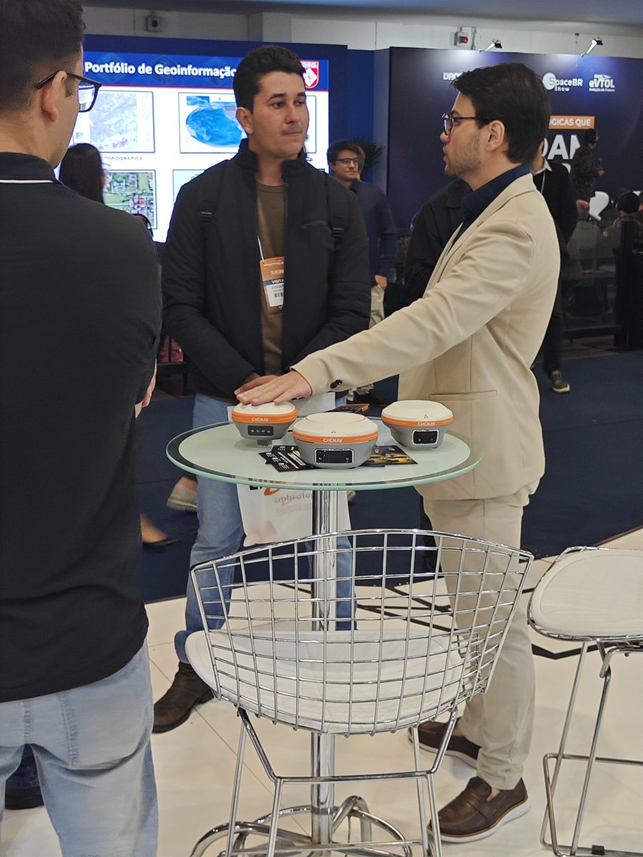
Visit us at MundoGeo to discuss the latest advancements in geospatial technology with CHCNAV and our partner CPE Tecnologia. This year, we are presenting solutions including the RS10 SLAM Scanner, AU20 LiDAR, and i93 GNSS Receiver. Meet us at booth #304 to learn more. 🌍📡🤝


The CHCNAV X500 UAV, with its 5kg payload capacity, enables easier airborne mapping using the AU20 LiDAR, operating simultaneously with the C30 RGB camera for efficient data collection. Discover how the X500 improves mapping efficiency: bit.ly/3GuAiSg

Planning to store your GNSS receiver long-term? Charge the battery to ~80% beforehand and recharge every two months to protect its lifespan. In daily use, simply avoid prolonged low-charge periods. #GNSS #BatteryCare

Adelaide ✓ Melbourne ✓ Next stop: Perth for our final Roadshow in this series! Discover our advanced Drone, LiDAR, SLAM Scanner & Marine solutions. DM us to talk with our professionals. #CHCNAV #Geospatial


In this video, our partner Mark shares his appreciation for the coordinate system capabilities in LandStar8 with our product manager Rachel, highlighting how this functionality streamlines the surveying process. Learn more:bit.ly/3R5a3DW #chcnav #surveying #landstar
In line with our commitment to transparency, our new ESG report offers an in-depth look at our efforts in environmental stewardship, social engagement, and robust governance. You can review the report and our progress here: bit.ly/43gTtXy


LAND SURVEYORS UNITED... @LandSurveyorsU
10K Followers 578 Following ʟᴀɴᴅsᴜʀᴠᴇʏᴏʀsᴜɴɪᴛᴇᴅ.ᴄᴏᴍ #ʟᴀɴᴅsᴜʀᴠᴇʏᴏʀs ᴛᴀᴘ ɪɴᴛᴏ ᴛʜᴇ #sᴜʀᴠᴇʏɪɴɢ ᴇxᴘᴇʀɪᴇɴᴄᴇ ᴏғ ᴏᴠᴇʀ 21ᴋ #sᴜʀᴠᴇʏᴏʀs ɪɴsɪᴅᴇ ʟᴀɴᴅ sᴜʀᴠᴇʏᴏʀs ᴜɴɪᴛᴇᴅ ᴄᴏᴍᴍᴜɴɪᴛʏ. ᴊᴏʙs, sᴜᴘᴘᴏʀᴛ & ᴍᴏʀᴇ ✊
Survey manufactory @metal_sega
2K Followers 5K Following one generation of life for surveying manufactory.# drone#Lidar#RTK#CORS#Totalstation#theodolite#level#tripod#prism#CAD mapping#GIS#big data #350km/h railway
陈文皓 @Billy_navigate
0 Followers 15 Following
Doug @BigRedBub
40 Followers 233 Following Very big follower of the BIG RED....around the Big O and so there
SpatiX @SpatiX_ai
6 Followers 11 Following SpatiX is the global leader of spatiotemporal intelligence founded in 2015, with Alibaba being our largest shareholder.
yrj @yrj89568112
1 Followers 3 Following
OdeliaLucy @w5OF9kStVJWzloK
3 Followers 172 Following
Savage Gyal @SavageGyal12689
6 Followers 105 Following
Sophia Zhao @Sophia66602
0 Followers 5 Following
Tina Li @Tina2024MCT
0 Followers 22 Following
Kaikai🍄💎 @Liuxi2601
36 Followers 357 Following
INGE🌐TERRA 🛰️... @IngeoterraIT
52 Followers 436 Following Ingeniería & Territorio 🛰️🌐/Planificación Territorial 🗺-Gestión Ambiental 🌳🐦/Topografía 🧭-Catastro🏘️/Sistemas Integrados de Gestión HSEQ ⚠️♻️
Joseph Njogu™ @njogujoseph
2K Followers 3K Following Entrepreneur | Visionary | Dreamer working to attain my dreams | Child of God | Passionate for Christ | Retweet ≠ Endorsement |BBM pin 55997BEF | @villacomltd
高维炜 @gowiwi3811861
0 Followers 22 Following
Fiyinfoluwa @Fiyinfoluw99
21 Followers 292 Following land surveyor/GIS expert A Chelsea football club fan💙💙 CR7 fan boy ❤

rsasaki0109 @rsasaki0109
7K Followers 212 Following Mapping and Localization Engineer at MAP IV(TIER IV group) GNSS/LiDAR/IMU/SLAM/Robotics

רועי סקורני... @Roye_Nik
60 Followers 2K Following Abstract: #Mechatronics #Engineering~Research/Design, #SpatialComputing, #Autonomous #Systems, 3+ octave Vocalist/Musician, #Multilingual, #Reforestation, Skate
Nyimi Dauda @NyimiD
8 Followers 78 Following

John Mullen @johnm1384
0 Followers 7 Following
Przemysław Turbańsk... @sith2025
0 Followers 20 Following
XÚ @darrrrrcy
3 Followers 17 Following
Luis Escobedo Cazán @Luis_EsKazan
202 Followers 198 Following Energías Renovables. Impresión 3D. Geomática. Procesos Bioalimentarios
Bil @AmanlikeBil
6 Followers 45 Following The earth is an oblate spheroid. Love yours. Astute Geomatisist
Gerhard @Gerhard_Goetsch
0 Followers 5 Following
توكلت علي ا�... @tarekghane66574
12 Followers 353 Following
çetin özcanlar @cetiiiinnn
22 Followers 108 Following
future @Arinzefuture
114 Followers 993 Following Oluwa Dey game🤲 Surveyor in making❤🙏 crypto euthanasia💯
八納由木夫 @7a30GGa5uA96889
1 Followers 29 Following
Jerry Leahy @JerryLeahy11
0 Followers 3 Following
A_Happy_Kid @AddalaRaed
77 Followers 1K Following Software Engineer based on 🇹🇳. Programming languages enthusiast. Scala & Haskell Enjoyer. C++ Hardcore fan. Turns out Functional Programming isn't that hard.
鸣 邱 @kimiqm65
3 Followers 23 Following
へるにゃ @hell_nya
183 Followers 2K Following 猫の成長記録からヲタ話まで色々つぶやきます。 仕事が始まったら農家ツイート多め。 農業 /猫/アニメ/steam/hololive(基本箱推しだけどメンバー🚑/ ※スパム垢はフォロー・リスト登録したら即報告・ブロックします。

Lobengula and Sugar�... @ashl2608
139 Followers 2K Following In order to hide a big lie people sometimes confess a small truth
Marlon Lopez @MarlonL8725120
2 Followers 89 Following
Hany Zakarea @Hanyz123
6 Followers 168 Following Business Development Manager| PMP | Civil Engineer | Geospatial solutions | Drones | MMS | 3D Scanning | GPR | GPS |
Xartakia_rizla_mple @xartakia
0 Followers 155 Following
libardo guerrero @libardo018
59 Followers 851 Following ING CIVIL .apasionado por el fútbol, enamorado de mi hijo
Rogue k @xxx_ke
23 Followers 634 Following
Kepler Geospatial @KeplerNAV
1 Followers 34 Following Independent research and development of BeiDou high-precision algorithms, dedicated to CORS service, high-precision navigation modules and surveying instruments
Freid Wong @FreidHuang
0 Followers 3 Following
Roko @Skarpun1979
0 Followers 5 Following
Midland Surveying and... @MSE_Survey
15 Followers 46 Following MSE have extensive experience in a wide range of industries. Our services include - topographical surveying, laser scanning and aerial photogrammetry
米山雅和 @yoneyamasvy
6 Followers 19 Following
Nusatrack @nusatrack_id
0 Followers 6 Following Elevate your projects with advanced survey solutions | Specialized in GNSS, drones, and geospatial technology Contact Us : 085697211370

Florid @werner1676008
1 Followers 1 Following
LAND SURVEYORS UNITED... @LandSurveyorsU
10K Followers 578 Following ʟᴀɴᴅsᴜʀᴠᴇʏᴏʀsᴜɴɪᴛᴇᴅ.ᴄᴏᴍ #ʟᴀɴᴅsᴜʀᴠᴇʏᴏʀs ᴛᴀᴘ ɪɴᴛᴏ ᴛʜᴇ #sᴜʀᴠᴇʏɪɴɢ ᴇxᴘᴇʀɪᴇɴᴄᴇ ᴏғ ᴏᴠᴇʀ 21ᴋ #sᴜʀᴠᴇʏᴏʀs ɪɴsɪᴅᴇ ʟᴀɴᴅ sᴜʀᴠᴇʏᴏʀs ᴜɴɪᴛᴇᴅ ᴄᴏᴍᴍᴜɴɪᴛʏ. ᴊᴏʙs, sᴜᴘᴘᴏʀᴛ & ᴍᴏʀᴇ ✊
Trimble Geospatial @TrimbleNews
10K Followers 174 Following Leading provider of advanced positioning solutions for survey and geospatial professionals that maximize productivity and enhance profitability.
Geo Week News @GeoWeekNews
5K Followers 2K Following Geo Week News covers the intersection between 3D tech, geospatial and the built world. Come see us in 2026!
Esri Eastern Africa @EsriEA
9K Followers 3K Following A professional geospatial solutions company which inspires, educates and enables our customers with working GIS solutions.
Drone&GIS @Drone_gis
96 Followers 146 Following Proporcionando múltiples servicios y aplicaciones a partir de información geográfica y drones....
Min. of Lands, Public... @Lands_Kenya
14K Followers 256 Following Official Twitter account of Min. of Lands, Public Works, Housing & Urban Development.
The Institution of Su... @isk_kenya
7K Followers 297 Following ISK is a Professional Body for Surveyors (Valuers & Estate Managers, Geospatial (Land), Building & Land Management Surveyors
Business Geomatics @BGGeomatics
1K Followers 1K Following Hier twittert die Redaktion der Wirtschaftszeitung Business Geomatics aus der Welt der Geo-Informationen.Everything is Somewhe... @surveying
8K Followers 185 Following Keeping the geomatics community informed via The American Surveyor Magazine, Everything is Somewhere podcast and more...
IASEXPO @aerial_systems
481 Followers 464 Following INTERAERIAL SOLUTIONS part of @InsideIntergeo as Digital Event with EXPO, FORUM and FLIGHT ZONE. Leadig platform for commercial drones: 13-15 OCT #IASEXPO
gis.Point @wichmannverlag
477 Followers 114 Following Das Portal für Geoinformation und Geodäsie Impressum: https://t.co/5dQlC6RyBw Datenschutzerklärung: https://t.co/sEj9tL6nZW
Geo:Connexion @Geoconnexion
2K Followers 329 Following Geo:connexion is the leading publisher for Geospatial professionals in UK, Europe, The Americas, Asia, Africa and the Middle East
OpenStreetMap @openstreetmap
83K Followers 219 Following OpenStreetMap is the free editable map of the whole world. It is made by people like you! @[email protected]
CHC Navigation UK @gps_uk
149 Followers 241 Following High Accuracy Precision Solutions for #Surveying #GIS #Marine #Construction #Geospatial industries.
eGPS Solutions, Inc @eGPSSolutions
131 Followers 171 Following Your #1 RTK network provider and full service survey equipment dealer in the Southeast! Equipment | Supplies | UAV-LiDAR | Tech Support | Repairs | Rentals
CADGIS Solutions @CadgisSolutions
128 Followers 99 Following CADGIS Solutions es una empresa con basta experiencia en Diseño Asistido por Computadora, Catastro, Base de Datos y Sistemas de Información Geografica.
MMSDesign.co.za @MMSDesignsIT
61 Followers 10 Following MMSDesign sell and support Model Maker Systems, #IrriMaker & #IrriExpress software, GPS and Laser equipment. We provide training and support.
Esri Canada @esricanada
13K Followers 3K Following Esri Canada provides geographic information system(GIS) solutions that empower people to make informed decisions using the power of mapping & spatial analytics.
FME Data Integration @SafeSoftware
5K Followers 2K Following Gain more value from data by connecting it across hundreds of sources with FME – the # 1 platform for integrating spatial data. #FME #DataIntegrationPlatform
Trimble Data @trimbledata
3K Followers 2K Following Map data. On demand. -- We are building the one stop marketplace for GIS and CAD data.
GW Events @GeospatialM
3K Followers 169 Following Premium Geospatial events produced by Geospatial World
Sensors & Systems @SensorsSystems
5K Followers 2K Following Sensors & Systems is focused on geospatial technologies that help us observe, measure, monitor and analyze Earth.
Eric Gakstatter @GPSGIS_Eric
3K Followers 114 Following I live in the world of high-accuracy GNSS/GPS, GIS, UAVs. Esri mobile GIS experts. Wrote for GPS World/Geospatial Solutions for 10+ yrs. FAA Pilot. Tesla owner.GPS Business News @gpsbusinessnews
13K Followers 1K Following GPS Business News is an online media providing business insights on mass market Geolocation applications for cars, smartphones and consumer electronics.
VINCI Construction @VINCIConstruc
20K Followers 1K Following This account is on pause. To keep up with our activities worldwide, check our website: https://t.co/nRuzb6GHAp
BIM WORLD @bim_world
4K Followers 950 Following #Construction, #Immobilier, #Aménagement #Urbain #Lowcarbon: 3 & 4 avril 2024. #BIM, #SIG, #3D, #SmartCity, #BIMWorld
The Survey Associatio... @surveyassoc
4K Followers 761 Following Formed in 1979, The Survey Association (TSA) is the trade association representing private land surveyors in the UK. #GetInvolved
Lidar News @lidarnews
6K Followers 1K Following Managing Editor of LiDAR News. Built Environment industry veteran focused on promoting, improving and developing the 3D laser scanning and lidar industries.
RIEGL @RIEGL
5K Followers 2K Following RIEGL delivers Smart Waveform technology in unmanned, airborne, mobile and terrestrial laser scanning solutions. https://t.co/3h8i1Riyxx
GIS Day @gisday
28K Followers 9K Following Celebrate GIS Day on November 20, 2024! Show how GIS makes a difference in your community and in the world.
What is GIS? @GISdotcom
23K Followers 15K Following GIS lets us visualize, question, analyze, interpret, & understand data to reveal relationships, patterns, & trends.
Esri User Conference @EsriUC
36K Followers 11K Following Join us for the world's largest GIS event, July 13-17, 2026! 🌎 #EsriUC2026
QGIS @qgis
64K Followers 63 Following Official account of QGIS - the user friendly Open Source Geographic Information System
GeoNe.ws @GeoNe_ws
7K Followers 2 Following Mastodon: https://t.co/qvSSThMkXA Bluesky: https://t.co/UWmVuPL8SB GIS and Geospatial related news and information. // by @michelstuyts.
MAPPS @MAPPSorg
5K Followers 649 Following MAPPS is the national association for private sector geospatial firms. MAPPS provides its 180+ member firms opportunities for networking and public policy.
GoGeomatics.ca @GoGeomatics
10K Followers 2K Following We are a communications channel for the geospatial industry, w/a focus on professional development, job opportunities, knowledge sharing & community building.
Esri @Esri
190K Followers 66K Following Esri builds #ArcGIS, the leading location intelligence and spatial analytics software for mapping, 3D GIS, imagery, and geospatial app development.
GISCafe @NewOnGISCafe
5K Followers 2K Following http://t.co/PeSrB0JIRa is the #1 Geographic Information Systems (GIS) Industry web portal
GeoInformatics @Geoinformatics1
12K Followers 4K Following GeoInformatics, knowledge for surveying, mapping and GIS Professionals. https://t.co/9lnwWufBK4
GPS World @GPSWorld
12K Followers 417 Following Our magazine has been publishing news about the business and technology of global navigation and positioning since 1990.
Inside GNSS @insideGNSS
2K Followers 980 Following INSIDE GNSS covers the global navigation satellite systems: GPS, Galileo, GLONASS, BeiDou, regional and augmentation systems and related technologies.
Sara Gu @CHC_Sara
13 Followers 42 Following
Geosistemas SRL @geosistemassrl
2K Followers 818 Following Soluciones geoespaciales, equipos y sistemas #GNSS para #topografía y #AgriculturaDePrecisión.
Galileo Instruments @galileo_ins
92 Followers 33 Following Líderes en Productos y Servicios Topográficos
CPE Tecnologia @cpetecnologia
503 Followers 553 Following Você procura equipamentos de geotecnologia e nós te oferecemos a solução!
CNES @CNES
192K Followers 2K Following L'actu du CNES, le Centre National d'Études Spatiales. Retrouvez les 3 infos de la semaine chaque vendredi sur notre chaîne WhatsApp.
🇪🇺 EUSPA - EU A... @EU4Space
19K Followers 913 Following EUSPA provides safe & performant #EUSpace Services, linking @CopernicusEU, EGNSS & SATCOM to EU citizens, and operates the @EU_SST Front Desk.
Galileo GNSS @GalileoGNSS
10K Followers 1K Following #Galileo - European Global Navigation Satellite System, #GNSS. Non-official account
Geocaching @GoGeocaching
74K Followers 362 Following Official Twitter handle of Geocaching HQ. Join adventure seekers searching for cleverly hidden containers around the world using our Geocaching® apps or GPS.
GIS and Science @GISandScience
30K Followers 10K Following Sharing issues and applications of geospatial technology for scientific research and understanding. Tweets by the @Esri Science Team with @deepseadawn
GIS Cloud @GISCloud
18K Followers 3K Following Operating on the fastest map engine available, we offer cloud-based GIS solutions for data collection, sharing, collaboration and publishing: [email protected]
Topcon Positioning Sy... @topcon_today
7K Followers 455 Following Meeting you at the Intersection of Infrastructure and Technology.Trends for United States
You might like