Command 1 @Command1fire
Wildland fires, Storms and breaking news. Retired Wildland fire captain. 🔥🚒 #wildlandfire USA Joined July 2025-
Tweets46
-
Followers8
-
Following170
-
Likes9
#ClubFire seems like the more equipment that gets on scene the bigger it gets. Is no one doing hoselays?


Lightning Fire - Area of Old Ridge Route s/o SR138 Angeles NF & Los Angeles County FD firefighters are responding to a confirmed lightning fire located on 8N04 two miles south of Pine Canyon @LACoFDPIO

New start in the #WheelerRidge area @kerncountyfire


Day 7 of @NWS_IMET_OPS IMET dispatch on the #GiffordFire. Hot/dry still the main themes, allowing for some good column development in the old growth fuels with the high mixing heights. The crews are doing a spectacular job, considering the fire behavior they are dealing with.
Day 7 of @NWS_IMET_OPS IMET dispatch on the #GiffordFire. Hot/dry still the main themes, allowing for some good column development in the old growth fuels with the high mixing heights. The crews are doing a spectacular job, considering the fire behavior they are dealing with.
#LeeFire burning just south of Meeker Colorado. One county road west of Hwy 13 & 2 road south of Hwy 64.

On scene of a new start in Placer County, off of Highway 65. 2 acres with a significant structure threat. #cafire


Multiple County Fire resources remain deployed assisting #USFS on #GoldFire north of Big Bear Lake. Two Type 3 engine companies, one water tender, one brush patrol and two chief officers are on scene. Latest update is 348 acres with zero containment. Follow @SanBernardinoNF…
#rosafire Air attack is requesting 3 nighttime copters. Flying with NODs has to be extremely difficult in a fire environment.
#RosaFire Evacuation WARNINGS have been issued for the following zones: RVC-2051 RVC-2052 RVC-1984 RVC-1983A RVC-2121 - North of Highway 74/Springcrest Dr. - South of Alpine Rd. - East of Pine View Dr. - West of Scenic Dr.


NEW START: Toiyabe National Forest, smoke is showing and units are en route (?)

Getting spicy! #rosafire

#RosaFIRE [UPDATE 8/4/25 3:00PM] The fire is now at 120 acres. Evacuation WARNINGS have been issued for the following zones: RVC-2051 RVC-2052 RVC-1984 RVC-1983A RVC-2121 North of Highway 74/Springcrest Dr. South of Alpine Rd. East of Pine View Dr. West of Scenic Dr. To…
Four fires are currently burning in Rio Blanco and Moffat counties in northwest Colorado. Evacuations have been ordered for the Elk Fire ➡️ ow.ly/ZTvc50WzyiB 📸 A view of both the Lee and Grease fires burning outside of Meeker, Colorado, Aug. 3, 2025.

#Rosafire Riverside County: Fire is 300 acres. Latest fire map #californiafireseason

Day 2 of @NWS_IMET_OPS IMET dispatch on the #GiffordFire. Expect conditions today to be similar to Sunday. So, will likely see continued plume activity on web cams. Still looking for increasing heat across the area, starting Wed. Fortunately, typical diurnal winds are expected
Day 2 of @NWS_IMET_OPS IMET dispatch on the #GiffordFire. Expect conditions today to be similar to Sunday. So, will likely see continued plume activity on web cams. Still looking for increasing heat across the area, starting Wed. Fortunately, typical diurnal winds are expected

#RosaFire the new spot fire on the south side is now well established.

#rosafire highway 74
#Goldfire San Bernardino national Forest Holcomb Valley: Fire perimeter 348.29 acres.

#GiffordFire perimeter map: 65,061 acres. This fire blew up fast, Its almost on track to be another Madre fire which ironically right next to this fire.


Widou @Widou575
7 Followers 289 Following
Kaumi @Kaumi381
39 Followers 490 Following
CJ. (1-0) @ceeJtweets
291 Followers 901 Following
Rich Thompson @RichIMET
3K Followers 3K Following Father, husband to @izennifer and IMET with NWS Los Angeles/Oxnard. Tweet about weather, wildfires, sports and occasionally politics. All opinions are my own.


Shasta Life @TheShastaLife
12 Followers 201 Following
WeatherWise.app @WxWiseApp
9K Followers 804 Following Free Mobile Apps: iOS: https://t.co/rrH1bIiWUP Android: https://t.co/lb3PumjYYE Browser: https://t.co/16ZMjL3x1l Desktop Apps: https://t.co/tjOGveseL0

Black Hills NF @BlackHillsNF
5K Followers 372 Following Black Hills National Forest, U.S. Forest Service. Caring for the Land and Serving People. Open M-F, 8 a.m. - 4:30 p.m.
Lassen NF @LassenNF
8K Followers 335 Following The Lassen National Forest lies at the heart of one of the most fascinating areas of California, called the Crossroads.
CAL FIRE AEU @CALFIREAEU
20K Followers 104 Following Official site for the CAL FIRE Amador-El Dorado Unit (AEU). Social Media Policy: https://t.co/i4RTePjOr7
ApacheSitgreaves NFs @A_SNFs
7K Followers 527 Following The Apache-Sitgreaves National Forests: 2 million acres of magnificent mountain country in east-central Arizona along the Mogollon Rim and the White Mountains.
Bighorn NF @BighornUSFS
726 Followers 32 Following The Bighorn National Forest in north central Wyoming encompasses 1.1 million acres of spectacular mountain scenery.
MarkTwain NF @marktwain_nf
1K Followers 327 Following Missouri’s 1.5 million acres of National Forest provides spectacular outdoor opportunities & resources in the beautiful Ozark Highlands. Come play!
Pueblo Interagency Di... @PIDC_FireInfo
76 Followers 45 Following Current fire information for Colorado's Pueblo Interagency Dispatch Zone https://t.co/b1AMXAZ3fw
NE Teller Co Fire Pro... @NETellerFirePIO
112 Followers 37 Following Serving the citizens of Woodland Park, CO and NE Teller County since 1985. **THIS FEED IS NOT MONITORED 24/7. IF YOU NEED EMERGENCY ASSISTANCE DIAL 911.**
Albuquerque Interagen... @NM_ABC
882 Followers 143 Following Albuquerque Interagency Dispatch Center coordinates wildfire response for multiple federal and state agencies in parts of NM, TX, and OK.
NWS Boulder @NWSBoulder
102K Followers 230 Following Official Twitter account for the National Weather Service Denver/Boulder forecast office. Details: https://t.co/A4aVgbxmgI
Lake Tahoe USFS @LakeTahoeUSFS
18K Followers 363 Following The Lake Tahoe Basin Management Unit encompasses over 156,000 acres of National Forest lands around beautiful Lake Tahoe! Follows/Likes/RTs Don't = Endorsement
PIO @PIOSBCFireInfo
800 Followers 26 Following This SBC Fire Account is for Assistant Public Information Officers. Comments and questions will not be monitored or answered. 805-896-6336
CAL FIRE LNU @CALFIRELNU
33K Followers 646 Following The @CAL_FIRE Sonoma-Lake-Napa Unit (LNU) covering Colusa, Lake, Napa, Sonoma, Solano & Yolo counties. https://t.co/zkWB11nCiQ


SBCountyOEM @SBCountyOEM
15K Followers 142 Following The Office of Emergency Management leads the Santa Barbara County Operational Area providing coordination and direction during emergencies and disasters.
R A W S A L E R T S @rawsalerts
1.3M Followers 2K Following RawsAlerts is your go-to source for fast and accurate news coverage, specializing in groundbreaking events. Powered by @Polymarket
RockyNPS @RockyNPS
82K Followers 85 Following The official twitter page of Rocky Mountain National Park. Updates and important information.
Larimer OEM @LarimerOEM
2K Followers 123 Following
poudrefire @poudrefire
12K Followers 658 Following Accredited fire agency serving 230 sq. miles of Northern CO including Fort Collins, Timnath, Laporte, Bellvue & surrounding areas. Service Above Self.
LETA @LETA_911
4K Followers 155 Following
Estes Valley Fire @estesfire
553 Followers 67 Following A volunteer force proudly protecting Estes Valley since 1907.
Dept. of Public Safet... @Arizona_DPS
78K Followers 168 Following AZDPS // Not monitored 24/7 - call 911 for emergencies // Public Information Manager: Warren Trent // PIOs: Sgt. Kameron Lee, Raul Garcia & Bart Graves
AzEIN 📢 @AzEIN
10K Followers 616 Following The AZ Emergency Information Network 📢 We’re the State of Arizona's official source for emergency updates, preparedness & hazard info. https://t.co/T68wnyyf61
Bureau of Land Manage... @BLMNational
48K Followers 1K Following Official account of Bureau of Land Management. Follow other BLM Twitter accounts at https://t.co/yjtGqfsBon…. RT/Follow ≠ endorsement
CAWildFire @CAWildfiretrack
1K Followers 169 Following Tracking California's Fires, mainly Northern California | Not affiliated with officials | Based in Placer County | Occasionally on the ground reporting.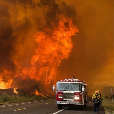
firevalleyphoto @firevalleyphoto
8K Followers 282 Following Providing Wildfire Coverage in the IE SoCal: Subscribe to my YouTube channel
FirePhotoGirl @FirePhotoGirl
67K Followers 421 Following Breaking News 🔥 Photographer/Videographer Team RMGNews 🎥
Bureau of Land Manage... @BLMArizona
7K Followers 529 Following Official account for the Bureau of Land Management in Arizona. BLM AZ Fire Info: @BLMAZFire https://t.co/icG62NEQ3I RT/follow/like ≠ endorsement
Kaibab NF @KaibabNF
10K Followers 128 Following The beautiful Kaibab National Forest is located in Arizona just north and south of the majestic Grand Canyon. More photos at https://t.co/kDzTn52m18…
Coconino NF @CoconinoNF
27K Followers 240 Following Official page for the Coconino National Forest. Visit our website for info about trails, recreation sites, events, news and much more!
Tonto National Forest @TontoForest
15K Followers 110 Following Official page of the Tonto National Forest in Arizona! #TontoNF is approx. 3 million acres and the ninth largest forest in the United States.
Ventura County Sherif... @VENTURASHERIFF
91K Followers 441 Following Official page for the VC Sheriff's Office. SERVE WITH INTEGRITY • PROTECT WITH HONOR. Subscribe to receive NIXLE alerts at https://t.co/yAZqQUE2xo
Dave Toussaint @engineco16
19K Followers 398 Following Retired Cal Fire, Fire Reporting, Wild Critter Lover, Photographer #BePrepared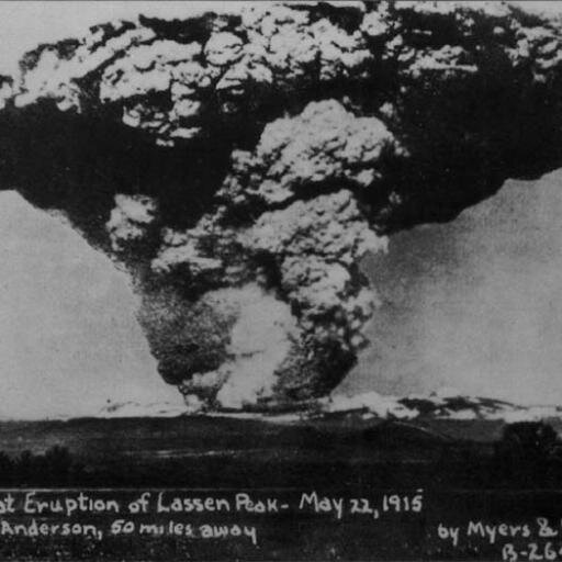
CaliforniaDisasters @CalDisasters
6K Followers 1K Following On https://t.co/SmHH56qgbx WX/Geo/Fire/Disaster/History Buff/CERT/Rockhound.
Rich Thompson @RichIMET
3K Followers 3K Following Father, husband to @izennifer and IMET with NWS Los Angeles/Oxnard. Tweet about weather, wildfires, sports and occasionally politics. All opinions are my own.
UCR Fire Information @UCRFireCenter
842 Followers 32 Following The Upper Colorado River Interagency Fire Unit includes the White River National Forest and the BLM Grand Junction and Colorado River Valley field offices.
UPPER PINE RIVER FIRE... @UpperPineFire
108 Followers 41 Following Rural EMS/Fire Department in Bayfield, Colorado
5280Fire @5280Fire
3K Followers 241 Following Colorado’s best source for fire scene and apparatus photography. Incident reports should not be considered verified until an agency PIO has officially done so.
Bureau of Land Manage... @BLMAZFire
15K Followers 641 Following Bureau of Land Management @BLMArizona Districts: ASD=Arizona Strip; CRD=Colorado River; PHD=Phoenix; GID=Gila https://t.co/9hm0Wvs36i - DM for PIO on duty. 🔥
LACoFD Bot @LACoFD_Bot
822 Followers 11 Following I am a bot that tweets callouts in Los Angeles County. Data from the Los Angeles County Fire Department. **NOT AFFILIATED WITH LACoFD**
VenturaCoAirUnit @VCAirUnit
15K Followers 192 Following Established by the Sheriff’ Office in 1971. In 2009, the Fire District and Sheriff’s Office entered into an agreement in which the Unit became a joint venture.
Coulson Aviation @CoulsonAviation
6K Followers 83 Following Global leader in aerial firefighting, emergency personnel transport, and heavy lift operations operating a fleet of fixed and rotary wing aircraft.
Cal OES FIRIS @FIRIS
21K Followers 19 Following Fire Integrated Real-Time Intelligence System: An all-hazard Cal OES mutual aid asset utilizing cutting-edge sensors to provide information for public safety
AZ Dept. Forestry and... @azstateforestry
31K Followers 98 Following Prevention and suppression of wildfire on 22 million acres of State Trust Land and private property outside incorporated areas.
FireMap.live 🔥🌎 @disaster_db
5K Followers 495 Following Real-wildfire data at your fingertips 🌍 | Visualize global wildfire activity instantly 🔥
NWS IMET Operations @NWS_IMET_OPS
7K Followers 225 Following Official Twitter account for NWS IMET program. More about IMETs: https://t.co/rhjAhpFXDv Details: http://t.co/mRyGMe9zKBTrends for United States
You might like