Andrew B @FireDataMan
I do planning, analysis, and GIS in support of wildland fire management. Coordinate, standardize, collaborate. Statements are mine; not my employer's. Boise, ID Joined April 2009-
Tweets3K
-
Followers412
-
Following294
-
Likes121
#Worldle #23 2/6 🟨⬜⬜⬜⬜ 🟩🟩🟩🟩🟩 worldle.teuteuf.fr Super fun geography knowledge/guessing game!

Here's something you don't see every day. #NC #Forest Service helo doing water drops on the #QVC distribution center in Edgecombe Co, after the major Efire overnight. Screen grab of rooftop video from FB user Reese Knight, source: facebook.com/reese.knight.7…

#COVID19Colorado update


Today, our own Andrew Bailey begins in the Data Management Technology Lead position, where he’ll support the interagency wildland fire community’s data needs. Previously, Andrew served as a Data Manager for wildland fire systems. He also participates in wildfire response.

When a service you stood up starts averaging 22 million requests a day :-O
Snowy and damp = perfect conditions for pile burning in central Oregon! BLM video: Nate LeFevre ow.ly/2J3P50y8btz
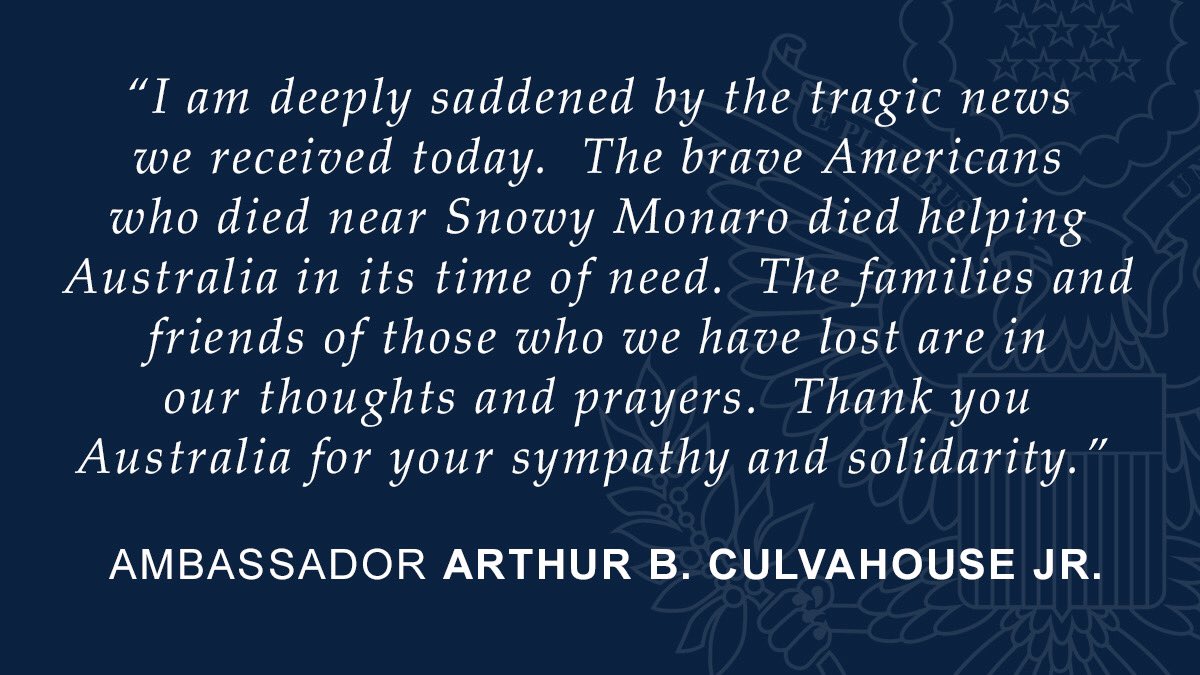
It's with heavy hearts that we offer our sincere condolences to the families & friends of 3 American crew members lost in a Large Air Tanker crash in New South Wales. The aircraft was contracted to @NSWRFS via @nafcaus, from Coulson Aviation. #NSWFires #USwithAUS #AustraliaFires

It's with heavy hearts that we offer our sincere condolences to the families & friends of 3 American crew members lost in a Large Air Tanker crash in New South Wales. The aircraft was contracted to @NSWRFS via @nafcaus, from Coulson Aviation. #NSWFires #USwithAUS #AustraliaFires
On schedule! #LANDFIRE's release of Great Basin and Southwest GeoAreas MoD-FIS data provisional products is now yours to use. Click on "Seasonal" on the LF Data Distribution site. ow.ly/9oMn50uwEjU.

#LANDFIRE provides the underlying data that are used in fire behavior analyses and project planning for IFTDSS. they're working on new features and functionality. Help us out; take the survey, would you? Much obliged. ow.ly/c72x50pGz06

This video describes and demonstrates the functionality of the three tiles users will see upon logging into IROC with user roles at a tier three dispatch center. youtu.be/0vnxCDXey6U

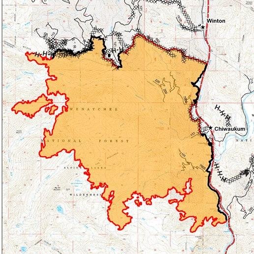
National Preparedness Level has been lowered to PL3. But more than 14,500 interagency personnel remain deployed to fight approximately 88 large #wildfires that are currently burning on about 1.7 million acres of private, state, tribal, and federal land.

🗺️#NowHiring @BLMcareers geographic information system (GIS) specialist in Boise. Apply @USAJOBS through August 13 ⏭️ usajobs.gov/GetJob/ViewDet…. 🗺️

Hey GISSs. I’m already starting to hear about lack of qualified GISSs in ROSS in some Geographic Areas and we’re only at Planning Level 3 nationally. Things are getting busier. Now would be a good time to become available if you can.
Tuesday's tidbit: #LANDFIRE was designed for and supported by federal wildland fire management agencies and is used by the entire wildland fire community, including federal, state and private organizations and individuals.

Here's what's happening in the world of IFTDSS - the Interagency Fuels Treatment Decision Support System. You asked and we listened! youtube.com/watch?v=LrTjVa…

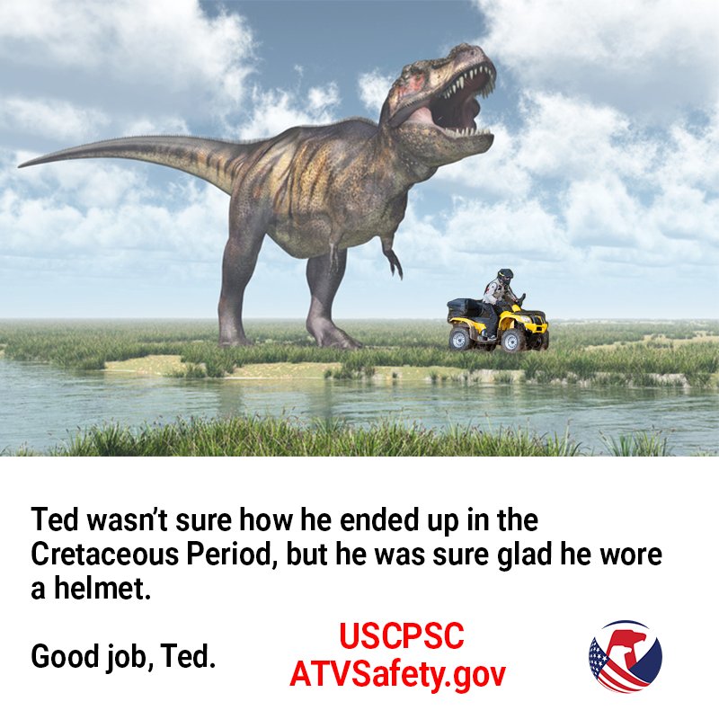
Always wear a helmet. Keep ATVs off roads #atvsafety ATVSafety.gov

What. A. GAME!!!!! @PackMensBball beats rival UNC-CH on the road 95-91 in OT! WOLF! 🐺🐾🏀
Fly to wildland fires in a helicopter... this is a real job. Check it out! mypubliclands.tumblr.com/post/170041855…

This incredible animation shows how deep humans have dug

Joey Doster @joeydoster
477 Followers 859 Following #Rule76. Tweets are words that are coming out of my mouth.
John Fisher @JohnAFisher
3K Followers 3K Following Retired Battalion Chief for a SoCal metro. PSC1/FBAN. Two hundred years of tradition enhanced by progress. Student of fire. More or less in line. Nov 2008.
USFWS Fire @USFWSFire
6K Followers 769 Following The USFWS fire program manages fire safely to improve landscape conditions, while reducing risk of wildfires to surrounding communities and wildlife.
IAWF @IAWF
7K Followers 760 Following The International Association of Wildland Fire is a membership association for wildland fire professionals around the world.
John Hawkins @JhawkFire
8K Followers 8K Following Wildland Fire Consultant - Fire Chief (ret) Formr CALFIRE/RivCo Fire Chief 12yrs - 55yrs FireServ LoveFF's & Serv'nPublic TransformationalServantLdr
🌬Miley💨 @whisppermiley
22 Followers 459 Following A little South American spice👑 Catch the burn on my FREE page💋
Open Space Ink @OpenSpaceInk
3 Followers 37 Following Musings on landscape dynamics. Topia Mutat. [email protected]. Also @mkasinskas.
Teataw @Teataw97923
33 Followers 1K Following
Sloatoa @SloatoaYypH
57 Followers 4K Following Do what you say,say what you do. https://t.co/G8eAhhYkN8
WUIPro @WUIPro_com
274 Followers 1K Following Essential wildland fire industry info for managers, insurance agents, RE agents, RE investors, prop managers & firetech startups in the Wildland Urban Interface
Emily @ShioledditadF8
36 Followers 3K Following
Sara Austen @actuallyBright
50 Followers 1K Following I'm a professional licensed binary trader and account manager.theres no limit to what you can achieve 🇺🇲
Stonirfr @Stonirfr2xvO92
28 Followers 2K Following I never feel lonely, to put it romantically, I am completely free.
DarleneDora @u09o57pqFtr2dJ
19 Followers 2K Following
EmergencyReports.com @emergencyreps
46 Followers 818 Following Making US emergency and fire information available to the public. Search our incident database for free at https://t.co/sw1C017fwD.
Mark Kasinskas @mkasinskas
23 Followers 61 Following
Todd Donovan, MS, FES... @FHCDonovan
165 Followers 294 Following Fire and EMS Data Analyst / Data Science / Accreditation Specialist for the Fayetteville (NC) Fire Department.

Data 2030 Summit @Data2030Summit
2K Followers 4K Following A strategy round-table event for professionals working with Information and Data Governance, MDM, Enterprise Data, Data Quality in the Nordics and MEA Region.
Data Innovation Summi... @DISummit2030
3K Followers 5K Following The most influential Data and AI Innovation event - Advanced Analytics, Data Science, ML, NLP, AI, IoT, Data Management and Engineering.
Data 2030 MEA @Data2030MEA
492 Followers 3K Following Data 2030 Summit MEA is a strategy event organised for professionals working with Information Management, Data Governance, Master Data Management, Data Quality,
Apollo Gerolymbos �... @FireDataGuy
1K Followers 1K Following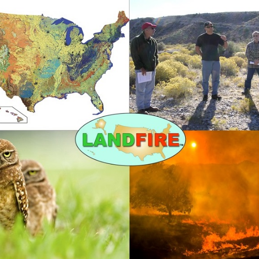
LANDFIRE @nature_LANDFIRE
4K Followers 3K Following LANDFIRE | National geospatial layers | Vegetation models for all major systems in U.S. | Product support | Supports land management
katie J Benson @katiebenson101
97 Followers 5K Following
Brian Auge @BrianHauge4
111 Followers 432 Following animation 🎞️ Landsat 🛰️ video dataviz #blender writing ✏️ geoscience 🌎 maps illustration 📷 photography weird stuff 🐒 🌊
Fire MDPI @Fire_MDPI
3K Followers 2K Following open access journal on fire by @MDPIOpenAccess. Current EiC: Dr. Grant Williamson @ozjimbob Founding EiC: Prof. Alistair Smith @pyroecophys Open Knowledge of🔥
Staci Matlock @StaciMatlock
2K Followers 771 Following Northern New Mexico journalist, mom, traveler, animal groupie, volunteer firefighter, lifelong learner. I retweet what I find interesting.

ITPeopleNetwork @ITPeopleNetwork
593 Followers 1K Following Helping enterprises protect their critical #ITInfrastructure. Follow us for the latest news & tips on #IOT, #Infosec, #cloud & #Bigdata
Ali Hassan Shabbir (P... @Dr_ALI_HS
666 Followers 5K Following #RemoteSensing, #GIS, #wildfire, #Hydrology, #Ecology, #Grassland, #Geospatial, #Climate
Nitya saha @Nityasaha14
92 Followers 1K Following Virtual assistant and data entry service provider.
Therese Ember @ThereseEmber
296 Followers 1K Following

(Chris) Fern @cofiregis
44 Followers 190 Following Mapper for disaster and emergency response. GIS can help responders stay safe and have more intel. Lover of all nature and travel!
Santhosh Shekar @santhoshshekar
573 Followers 3K Following Author | Accredited ISO KM Auditor & Certifier | MiKE| FIKE| CKM | Knowledge Management Architect

International Public ... @TheIPSDI
882 Followers 2K Following The International Public Safety Data Institute procures, assembles, analyzes, and reports information from fire, rescue, and law enforcement data.
Chad Anderson @pyroeco
515 Followers 777 Following
Jesse Crocker @skiercrocker
201 Followers 260 Following Software Engineer, specializing in outdoor mapping. Previously at Gaia GPS. Now mostly Skiing.
Chloeta Careers @ChloetaHires
7 Followers 126 Following Employment opportunities and information for @chloetafire, a leading provider of operational support services worldwide.
Koordinates US @KoordinatesUS
14 Followers 119 Following New and updated US geospatial data layers from @Koordinates

Heath Beckett @HeathBeckett
397 Followers 873 Following Senior Researcher | Stellenbosch University | School for Climate Studies | Global Change Biology Group @GCBGLab


Krista West, Ph.D. @RSFireNerd
4K Followers 4K Following Pyrogeographer. #RemoteSensing of Wildfire. 🛰🛩🔥 | Passionate about finding ways to help first responders 👩💻❤️🚒
Kramer Newman @VandalayExport
705 Followers 4K Following
jdotson.bsky.social @uncrown87
597 Followers 2K Following California native. Relocated to Ky. Alive for the polycrisis.
John Abernathy @AbernathyJohnM
62 Followers 2K Following
bthor @RevBenT
90 Followers 273 Following Husband, father, and Battalion Chief in Dallas Fire-Rescue. Coordinator of preventative mental health programs, and certified https://t.co/byBTgdgF0r trainer.
Wildland Fire Photogr... @Codycthompson
136 Followers 469 Following Wildland firefighters specializing in Wildland Fire Photographer
Ben Jeffrey @bjeffrey780
32 Followers 443 Following

Bureau of Land Manage... @BLMFire
27K Followers 2K Following BLM Fire prioritizes firefighter & public safety while protecting natural landscapes, wildlife habitat, & recreation areas.
National Wildfire Coo... @NWCG
10K Followers 290 Following NWCG provides national leadership to enable interoperable wildland fire operations among federal, state, local, Tribal, and territorial partners.
USFWS Fire @USFWSFire
6K Followers 769 Following The USFWS fire program manages fire safely to improve landscape conditions, while reducing risk of wildfires to surrounding communities and wildlife.
IAWF @IAWF
7K Followers 760 Following The International Association of Wildland Fire is a membership association for wildland fire professionals around the world.
NW Fire Science Conso... @NWFireScience
3K Followers 509 Following Working to accelerate awareness, understanding, and adoption of wildland fire science in Oregon and Washington.
TopQuadrant @TopQuadrant
2K Followers 167 Following Create a semantic ecosystem, the next step in data evolution.
FME Data Integration @SafeSoftware
5K Followers 2K Following Gain more value from data by connecting it across hundreds of sources with FME – the # 1 platform for integrating spatial data. #FME #DataIntegrationPlatform
Jesse Crocker @skiercrocker
201 Followers 260 Following Software Engineer, specializing in outdoor mapping. Previously at Gaia GPS. Now mostly Skiing.
Dave Hammond @DaveHammond13
30 Followers 299 Following
Amanda Peacher @amandapeacher
8K Followers 2K Following Sr. acquisitions editor @Marketplace. Hiker. Biker. Mama. She/her
Uli Bethke @ubethke
5K Followers 22 Following CEO Sonra. Parse any SQL. Data Lineage. Convert any XML and JSON.
DOIWildlandFire @DOIWildlandFire
5K Followers 718 Following Wildland fire management at @Interior spans 500 million acres & thousands of personnel. The Office of Wildland Fire provides budgeting, policy & innovation.
FOSS4G North America @foss4gna
3K Followers 1K Following FOSS4G NA 2024 - Sept. 9-11 - St. Louis, MO
Kathie @kathie_hansen
7 Followers 50 Following
1Weather @OneLouderApps
4.7M Followers 38K Following 1weather - trusted source of weather for 35M users
The Glasers @TheGlasersInc
2K Followers 1K Following Drs. Peter and Susan Glaser, the PhDs behind Glaser & Associates, bring innovative communication and leadership solutions to an international audience.
GeeSnarfGee @GeeSnarf
34 Followers 12 Following Striving to live as genuinely and energetically as my dog. connecting dots.
GISS @GISSERS
23 Followers 58 Following
Michael @N115Z_NIROPS
410 Followers 93 Following ***Non-official disclaimer*** Any news organizations that retweet my tweets will be removed from my followers list. Sorry!
Wade Dorrell @waded
1K Followers 495 Following Quality, human factors, gardening, denominators, negative space, late-stage dadops, LLAP, LLTBTB
Bureau of Land Manage... @BLMIdaho
8K Followers 421 Following BLM manages nearly 12 million acres of public lands in Idaho, nearly one-fourth of the state's total area.
Sean Triplett @setrip76
35 Followers 73 Following I have a passion for herding cats and hunting seagulls
QUEST Research Group @QUEST_RCN
101 Followers 50 Following QUEST is a Research Coordination Network dedicated to advancing uncertainty analysis in ecosystem studies. Efforts focus on both outreach and research.
Fire_Mapper @Fire_Mapper
100 Followers 37 Following
Renee Jacokes-Mancin @IRIN_Renee
32 Followers 3 Following
Joe Larson * @3400maps
183 Followers 109 Following FORMER*: GIS Specialist, Infrared Interpreter, Geospatial Analyst (GSAN). Assignment/work/public account for Joe Larson, CAL FIRE / San Luis Obispo County Fire.
Northwest Interagency... @NWCCInfo
12K Followers 889 Following The Northwest Coordination Center (NWCC) coordinates #wildfire and all risk incidents for 11 agencies in #Oregon and #Washington.
Sean Triplett's Vest @Seans_Vest
2 Followers 3 Following
Reginald Goolsby @Pyronerd62
115 Followers 140 Following Find me over on Bluesky https://t.co/KNFQoj7gZq
Melanie Hans @mrhans23
6 Followers 4 Following
WIFIRE Lab @WIFIRELab
634 Followers 121 Following WIFIRE Lab at UC San Diego develops science-driven technologies with the fire management community using collaborative workflows integrating science and AI.
Ely Interagency Fire @Ely_Dispatch
417 Followers 7 Following News and notes from the Ely interagency fire dispatch.T1 GB IMT (Harvey) @T1GBIMTHarvey
412 Followers 62 Following Type I Great Basin Incident Management Team (Rich Harvey IC)
GB MAC Group @GreatBasinMAC
26 Followers 2 FollowingGIS Python Questions @GISPyQuestions
437 Followers 0 FollowingPython StackOverflow @pystack
453 Followers 0 Following A feed of questions from Stack Overflow tagged Python that meet some criteria. Aiming for 12 tweets a day.
Joaquin Ramirez 🙏�... @jramireztsyl
2K Followers 1K Following President & CTO @Technosylva , Professor Technologies on Wildland Fire @unileon, former President @IAWF 2021-2023
LAStools @LAStools
5K Followers 477 Following highly efficient, batch-scriptable, multicore command-line tools for lidar processing. Standalone, native GUI, toolboxes (QGIS, ArcGIS Pro, FME, Erdas).
The National Map @USGSTNM
8K Followers 127 Following This is an archived account and is not being updated. For the latest updates follow @USGS.
Geo-Fencing @GeoFencing1
2K Followers 2K Following Geofencing is available as a component of the MAPCITE SDK. So if you need Geofencing technology that integrates with your other tech just ask for a demo.
GovLoop @GovLoop
24K Followers 4K Following GovLoop is the knowledge network for #government, connecting 300,000+ #federal, #state, and #local gov #innovators.
Data.gov @usdatagov
29K Followers 312 Following The central clearinghouse of the U.S. Government’s open data.
Incredible Data @Incredible_Data
8K Followers 1 Following Welcome to the land of Data, Info-graphics, Data Visualisation and much much more.
NSGIC @nsgic
4K Followers 246 Following State-led sharing of best practices. Critical connections. #Geospatial awareness and advocacy.
Dr Nancy von Meyer �... @vonparcel
404 Followers 698 Following This account is for land records, GIS, parcels, improving decisions with better data, science, all maps vonparcel @bsky.social
WFF @wffoundation
4K Followers 2K Following Honoring, supporting, and serving those who protect our natural resources from wildfire.
Emergency Management @EmergencyMgtMag
16K Followers 859 Following The official Twitter page of Emergency Management magazine.
Rob Simmon @rsimmon
8K Followers 2K Following Data visualization, cartography, & remote sensing. Ex @Planet & @NASAEarth. Blue Marble, Earth at Night, color. https://t.co/BDzRqYMing
Bureau of Land Manage... @BLMIdahoFire
10K Followers 238 Following BLM Idaho protects and manages wildfire on approximately 11 million acres. https://t.co/eBB8qNyVWr
Cohesive Strategy @US_Wildfire
3K Followers 901 Following The National Cohesive Wildland Fire Management Strategy. RTs/favs are not endorsements. #wildfire #CohesiveStrategy https://t.co/UEuDF3vedU
FHS Publications @FHSPubs
307 Followers 379 Following Updates on FHS books, films, publications like Forest History Today magazine, and blog from @foresthistory and other publishers.Trends for United States
You might like