
Open Data Cube @OpenDataCube
A free and open data architecture for increasing the value and global impact of satellite Earth observations opendatacube.org The World Joined December 2017-
Tweets162
-
Followers3K
-
Following34
-
Likes104
Version 1.8.41 of Datacube-OWS is now available and includes a new feature: Multi-date handlers for colour ramp styles can now operate on raw band data, enabling many new visual comparison techniques that were not previously supported. github.com/opendatacube/d…
1.8.19 release of the Open Data Cube includes a fix to a bug in COG generation code affecting floating point bands, that adversely affected both ESRI and GDAL handling of ODC-generated floating point COGs. github.com/opendatacube/d…
ODC 1.8.18 is now available. It contains bug-fixes, enhancements and changes to smooth the transition to Open Data Cube 1.9.x. Future development will focus on the 1.9.x series, but 1.8.x maintenance releases will continue for the forseeable future. github.com/opendatacube/d…
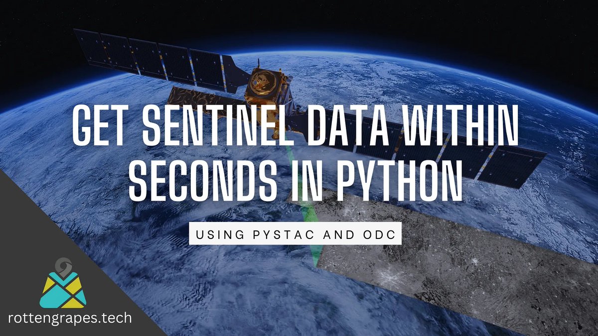
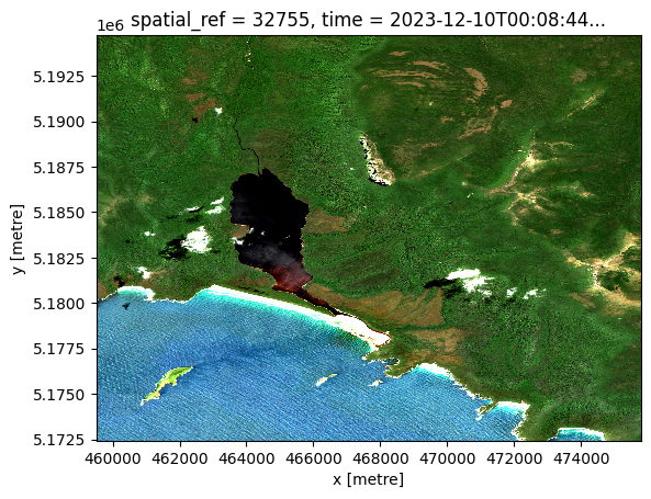
#TutorialTuesday: Learn how to access satellite data in seconds! This guide by @krishnaglodha shows you how with Python using pystac and ODC. medium.com/rotten-grapes/…

New Datacube-OWS release: github.com/opendatacube/d… Datacube-OWS provides WMS, WMTS and WCS services for the @OpenDataCube Includes some minor bugfixes and security patches. Thanks to all contributors and supporting organisations
Learn how to load satellite data from anywhere on #TutorialTuesday! @alexgleith breaks it down with 2 Python libraries and 6 lines of code – all in just 15 seconds. Get started today with the notebook gist.github.com/alexgleith/dc4…

Qiusheng Wu @giswqs
46K Followers 4K Following Associate Professor @UTKGeography | @Amazon Scholar | Talk about #opensource #geospatial #dataviz #EarthEngine

Digital Earth Africa @DEarthAfrica
7K Followers 260 Following #DigitalEarthAfrica translates satellite data into easy to consume information for the entire African continent.
Mike Wulder @mikewulder
14K Followers 6K Following Senior Research Scientist with the Canadian Forest Service. 🍁 #Landsat super-fan. #Lidar. #Forests. #Remotesensing. 🌲🛰 Member of the #OrderOfCanada. 🎖
Dr Robbi Bishop-Taylo... @SatelliteSci
8K Followers 5K Following Posting at 🦋. Earth Observation Scientist at @GeoscienceAus. Using satellites 🛰️ to study the earth 🌍 through space and time
Ryan Abernathey @rabernat
7K Followers 2K Following Scientist and Startup Founder Co-founder and CEO @EarthmoverHQ @pangeo_data steering council member ex-Professor @columbia @lamontEarth
Group on Earth Observ... @GEOSEC2025
19K Followers 4K Following 🛰️ Translating Earth Intelligence with global collaboration. ℹ️ https://t.co/I3zKOfaBls #EarthIntelligenceForAll #MapEcosystems
Sisters of SAR @SistersofSAR
10K Followers 4K Following A passion for all things #SAR | #WomeninSAR | @eoscenefrom | We 💜@LadiesofLandsat & @DamesofDrones| Tweets by @LDR1, @SAR_ahBanks, @Go__Pika & @ant_dasgupta |
GMES, and Africa @GMESAfrica
4K Followers 2K Following The #Global #Monitoring for #Environment and #Security Programme of @_AfricanUnion and @EU_Commission for #EarthObservation in support of #TheAfricaWeWant

🛰🌍🌊Dr Hayley... @HayleyEversKing
7K Followers 6K Following Satellites, Sea, Society! Bridging gaps between data providers&users, @eumetsat &beyond. Immigrant. Cooking sustainably.🐈🐈. #MHFA💚 She/Her. Views my own etc
TERN @TERN_Aus
8K Followers 6K Following NCRIS-enabled national observatory for Australian ecosystems, delivering infrastructure and data for environmental research and management. #NCRISimpact

Dr. Catherine Nakalem... @CLNakalembe
5K Followers 2K Following Professor Innovating in #AI #EO #Agriculture #ClimateChange @umdgeography @UofMaryland, NASA’s @Harvestprogram Africa Lead- Winner #AfricaFoodPrize / #Al-Sumait
Kenya Space Agency @SpaceAgencyKE
11K Followers 318 Following Kenya Space Agency's Official Page. Our mandate is to Promote, Coordinate and Regulate Space related activities in Kenya.
Arjen Vrielink @arjenvrielink
2K Followers 822 Following Owl at @satelligenceEO, RemoteSensing, OpenSource, theSwarm, Containers, Patterns. “Bacteria that turns shit into fuel” - the Mouth of Joe.
Justin Braaten @jstnbraaten
7K Followers 2K Following DevRel for @google #EarthEngine Interested in #Conservation #Landsat #EO #TimeSeries #DataViz
EU Defence and Space @defis_eu
28K Followers 2K Following @EU_Commission Directorate-General for Defence Industry and Space l DG DEFIS 🇪🇺 Commissioner @KubiliusA #EUSpace #EUDefence
Gilberto Camara @gcamara
11K Followers 1K Following Researcher on Geoinformatics, Land Use Change and Spatial Data Science. Former Director of INPE/Brazil (2005-12) and of Group on Earth Observations (2018-21).
R. Fernando Molina R. @rafemoro
3K Followers 745 Following Geógrafo, amante de su familia, deporte y el fútbol , me interesan los #datosabiertos #mapas #geospatialdatascience
@MicheleMussoni @MicheleMus65174
2 Followers 230 Following
Harsh Shinde @harshinde_hks
8 Followers 136 Following Exploring and learning new coding languages, expanding my repertoire and problem-solving capabilities. YouTube - https://t.co/RzcK78pARc
Dr Muhammad Moshiur R... @MoshiRahman18
25 Followers 123 Following Dr Moshiur Rahman is a senior researcher with more than 10 years’ experience in precision agricultural technologies, Remote Sensing and Crop-climate Modelling.
Leviathan @wohkoon
194 Followers 3K Following Son, Husband, Father, Researcher, Geek and Tech enthusiast.
Armand Stroman @ArmandStro5543
52 Followers 2K Following
Chris @elcatech
2 Followers 38 Following
Heather LaDue @HeatherL72880
18 Followers 2K Following


Data Strategy in a Nu... @SomethingData
192 Followers 497 Following Data & Analytics Strategy Consultant - #DataLiteracy #DataCulture #DataGovernance #DataStrategy #DataArchitecture Explore my SAP-minded Twitter: @sapanalytix
kkfuti @kkfuti
65 Followers 883 Following
Victoria @vikineema
13 Followers 297 Following
Sangay Pelzang @PelzangSangay
12 Followers 28 Following
Thomas E Fleming @thomasefleming
34 Followers 2K Following
Franklin Barto @FranklinKBarto
56 Followers 625 Following Chief Executive Intern @ https://t.co/zr5O0Le2JO | https://t.co/qIZML1gxQv Interested everything Data and AI
govindv ver @Gverma_24
5 Followers 80 Following
Jackie @robertmaurerfan
942 Followers 3K Following Anti-bot-keyword: 天安門事件. One Spx trade a day, keeps doctor away.
Carlos Caballero Y. @carlaoca
716 Followers 5K Following - Paraguay🇵🇾 - ERP Yakare - Bi-ANDA - FirebirdSQL Consultant - Familia - Ciclon💙❤️💙🌪️ - Metallica🤘 - Chorizo Sanjuanino - Beer🍻 & Terere
Croissant Haver @Liz__Bastos
670 Followers 1K Following the urban environment and machine learning 59% water, 40% French pastry, 1% ArcGIS. ✍️

Viola Coppi @CoppiViola4962
0 Followers 14 Following
Samuel Onasanya @OnasanySam72243
265 Followers 4K Following
Gatot Pramono @gatothp
102 Followers 124 Following
Geospatial Research F... @GeospatialRF
1K Followers 7K Following we use #Al to model climate patterns, LULC change, identify trends and make predictions|Email; [email protected]
Bruce O'Neel @BruceONeel2
72 Followers 2K Following
SabireH @sbrh61
22 Followers 2K Following
Kunal Kapoor @BuzzingBorders
18 Followers 478 Following Borders are weird. So are bees. I study the former and care for the latter

Eliana @ebgonzal1602
3 Followers 111 Following
~tõny~♌️🇨🇻... @antoinedacost13
91 Followers 257 Following Géographe Climatologue🌊🌏🎓Senegales🇸🇳 boy👉🏾gentlemen😇christian✝️I❤️JESUS my shepherd🙏🏾😅😅🥰 #GIScommunity
Goddess💕Dana💕Ni... @EminemsSecretGf
117 Followers 2K Following Eternal goddess of desire and pure bliss. Magical & mysterious moonlight muse. Alluring enigma. Dreams in color, lives in B&W. Caskey’s better half - or is she?
KrypticVex @KrypticVex11
4 Followers 84 Following
Alex ✌🏼 @alexdelapaz_
42 Followers 553 Following https://t.co/dqMGRpQsQ7 🌐📡🛰🌎 Artificial intelligence, mapping, and perception.
Upendra Yadav @Shreyas_sarthi
95 Followers 1K Following MSc.Disaster Mgmt || Climate science || Remote Sensing || Geography || Python || ML/AI 🗺️🎨🎭 Indian Meteorological Department (Intern)
hrivas @hdavidrivas
184 Followers 2K Following

Magi Pàmies Sans @magimagnin
454 Followers 2K Following
Alfredo LF @ajlf88
455 Followers 7K Following Caribeño Colombiano; Orgulloso Hijo de la Universidad Pública; No hay Preguntas estúpidas; Amante de la Naturaleza; Ser Curioso...

Indiphile Ngqambuza @Made_In_South_A
19 Followers 356 Following
Williams Omotayo Adaj... @willieonibata
61 Followers 307 Following A geologist and geospatial analyst interested in creating solutions to make research easier. Lover of God, python and QGIS. Oh Yeah! Arsenal For Life
Patrick Ken Kalonde @KalondePatrick
678 Followers 1K Following Fulbright 2020 | Copernicus Masters 2021 | PhD student | Computational Scientist
Forestry TEP @forestry_tep
282 Followers 101 Following The Forestry Thematic Exploitation Platform (F-TEP), operated by @VTTFinland and supported by @ESA, offers a one-stop shop for forestry remote sensing services.
icebreg @icebreg215246
13 Followers 45 Following
Zhe Zhu 🌎🛰️ @GERSLab
4K Followers 2K Following Associate Professor @UConnNRE, Director of Global Environmental Remote Sensing Laboratory, Associate & Special Issue Editors of RSE & SRS.
Copernicus EU @CopernicusEU
135K Followers 2K Following The Earth Observation component of the EU Space Programme
ESA Earth Observation @ESA_EO
143K Followers 3K Following @esa #EarthObservation: Taking the pulse of our planet from space. Please see our Privacy Notice: https://t.co/zzMYcxj8xi
Digital Earth Africa @DEarthAfrica
7K Followers 260 Following #DigitalEarthAfrica translates satellite data into easy to consume information for the entire African continent.
Group on Earth Observ... @GEOSEC2025
19K Followers 4K Following 🛰️ Translating Earth Intelligence with global collaboration. ℹ️ https://t.co/I3zKOfaBls #EarthIntelligenceForAll #MapEcosystems
Dr. Catherine Nakalem... @CLNakalembe
5K Followers 2K Following Professor Innovating in #AI #EO #Agriculture #ClimateChange @umdgeography @UofMaryland, NASA’s @Harvestprogram Africa Lead- Winner #AfricaFoodPrize / #Al-Sumait
EO OPEN SCIENCE @EO_OPEN_SCIENCE
15K Followers 827 Following European Space Agency account for the #EarthObservation (EO) #OpenScience user community. Exploring challenges & opportunities created by revolutions in #EO.
gdal org @GdalOrg
4K Followers 6 Following No longer here. Find us at @[email protected] GDAL is a translator library for raster and vector geospatial data formats.
WomenOfWaveforms @WomenofWaves
638 Followers 245 Following Reaching out to all women passionate about lidar. #WomenInRemoteSensing | #STEMinism | We 💜 @SistersofSAR and @LadiesofLandsat | Tweets by @HeatherKayMTB
Open Geospatial: OGC @opengeospatial
27K Followers 230 Following OGC’s member-community of experts makes location data Findable, Accessible Interoperable, and Reusable (FAIR) through #innovation #collaboration and #standards
SDGs Today @sdgstoday
2K Followers 532 Following A program of @UNSDSN focused on timely #data & #GIS for the #SDGs. Launched in partnership with Esri and the National Geographic Society.
Ladies of Landsat @LadiesOfLandsat
11K Followers 5K Following ALL are welcome! | #STEMinism | We 💜 @SistersofSAR, @WomenofWaves & @DamesofDrones! | Website coming soon!
Earth Observation Aus... @EarthObsAu
752 Followers 201 Following Earth Observation Australia is a community group for ALL people who collect and use earth observation data in Australia #earthobservation #EO #remotesensing
Element 84 @Element84
5K Followers 3K Following 🚀 Accelerating and 🌲 scaling impactful projects with great software and design. Woman-owned.
Radiant Earth @OurRadiantEarth
8K Followers 1K Following Increasing shared understanding of our world through community-led initiatives that make data easier to access and use.
CNG @cloudnativegeo
1K Followers 113 Following Where geospatial data users create the future together.


SciPy @SciPy_team
7K Followers 23 Following SciPy provides fundamental algorithms for scientific computing with Python: statistics, optimization, linear algebra, integration, interpolation, signal, etc.
SpatioTemporal Asset ... @STACspec
2K Followers 15 Following Enabling online search and discovery of geospatial assets.
Cloud Optimized GeoTI... @cogeotiff
2K Followers 11 Following I like to say that I'm like a regular GeoTIFF but in reality, I'm way better! Not a big fan of @JPEG_2000 #TeamCOG - gdal_translate -of COG
NumPy @numpy_team
37K Followers 11 Following Official account of NumPy. Announcements only. For questions and comments, please use the mailing list [email protected].

Geoscience Australia @GeoscienceAus
19K Followers 879 Following Australian Government. Earth sciences for Australia's future. Follow @EarthquakesGA for latest information.
UNDRR @UNDRR
114K Followers 1K Following #UN Office for Disaster Risk Reduction, dedicated to building disaster #resilience and tackling #climatechange through implementation of the Sendai Framework
Blue Planet @GEOBluePlanet
3K Followers 487 Following #GEOBluePlanet is a global initiative to ensure the sustained development and use of coastal and ocean observations for the benefit of society.
FOSS4G 2024 | https:/... @foss4g
18K Followers 592 Following The world’s largest gathering of open source geospatial users, developers, and researchers. FOSS4G | https://t.co/wtkKL1RgOW
SERVIR Global Collabo... @SERVIRGlobal
7K Followers 493 Following The SERVIR Global Collaborative is a network of hubs and partners advancing SERVIR’s legacy through geospatial innovation and local capacity building.
EOHandbook @EoHandbook
225 Followers 176 Following Publication and satellite database from https://t.co/mIUYL7L72E interested in Earth Observation Satellites studying Weather, Climate, Land, Water, Oceans, Atmosphere and more!
EO4SDG Initiative @EO4SDG
4K Followers 637 Following EO4SDG extends the use of Earth observations to advance sustainable development globally through achieving the #SDGs. @GEOSEC2025
SwissDataCube @SwissDataCube
589 Followers 38 Following Official account of the Swiss Data Cube - EO for monitoring the environment of Switzerland in space and time
GEOGLAM RAPP @GeoglamRAPP
291 Followers 26 Following GEOGLAM Rangelands and Pasture Productivity monitors the world’s rangelands and pasture lands, and their capacity to sustainably produce animal protein
Gregory Giuliani @greggiuliani
852 Followers 923 Following Senior Lecturer @UNIGEnews & Head of Unit @GRIDgva. Interests: EO, GIS, SDI, Open Data & environmental sciences.
UNEP/GRID-Geneva @GRIDgva
661 Followers 71 Following is a @UNEP office, which transforms #data into Information & Knowledge for #Environment #climatechange, using #GIS, #remotesensing, SDI & other geospatial tools
CEOS @CEOSdotORG
5K Followers 454 Following The Committee on Earth Observation Satellites (CEOS) ensures international coordination of civil space-based Earth observation programsTrends for United States
You might like