PointCloudTechnology @PointCloud_Tech
Point Cloud Technology offers a universal platform for big data analytics on 3D point clouds based on machine learning. pointcloudtechnology.com Potsdam, Germany Joined August 2015-
Tweets69
-
Followers198
-
Following32
-
Likes115
Rico Richter spricht zum Abschluss des Projekts zur Entwicklung von Verfahren zur (teil-)automatisierten Erstellung von BIM-Modellen für Straßenbrücken im Bestand der Bundesanstalt für Straßenwesen über die Ergebnisse, die in der Zusammenarbeit mit dem HPI erzielt wurden #ki #bim

Heute findet der FachTAG - #CAD und #GIS von Widemann Systeme auf dem malerischen Schloss Dyck statt. Im Vorfeld des Events wurde das Schloss digital erfasst. Das ist bei @PointCloud_Tech abrufbar: 3D-Modell: lnkd.in/e2sHYxff 3D-Point Cloud: lnkd.in/er98mWXM

Am @WidemannDE-Fachtag gibt es viele Praxisbeispiele, die zeigen wie kostenfrei verfügbare #3D-#Punktwolken und Bestandsgeodaten für die Verwendung in Katastern aufbereitet und eingespielt werden können. Anmeldungen sind noch möglich: widemann.de/aktuelles/even… #ki #pointclouds

Datenbank für #Straßenraum auf #KI-Basis - "denn das Verkehrsaufkommen steigt, Mittel für die Instandhaltung sind begrenzt und digitale Prozesse für die Zustandsbewertung und Instandhaltungsplanung fehlen nach wie vor an vielen Stellen." Der ganze Artikel: business-geomatics.com/2022/01/27/dat…
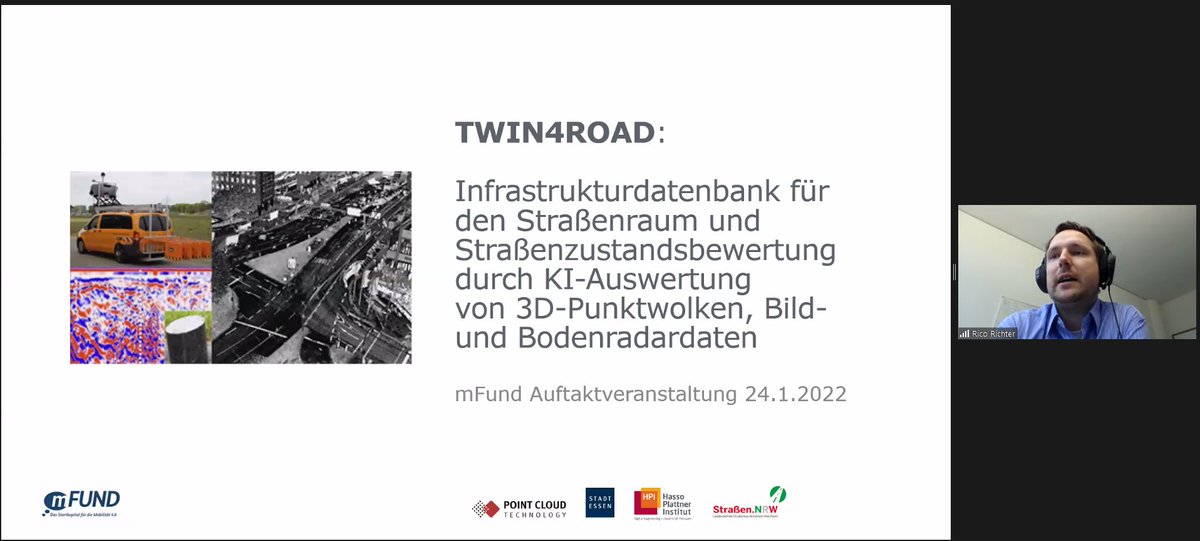
Auftaktveranstaltung für das #mfund Projekt mit dem @BMDV_bund und @Essen_Ruhr: Wie kann #KI bei der Straßenzustandsbewertung und bei der Schaffung einer Infrastrukturdatenbank des Straßenraums helfen?
Targomo is growing and looking for new team mates! Check out our open positions here: hubs.li/Q011MBRC0 #wearehiring #startupjobs #locationtech #scaleup
Wie können 830.000 Kilometer Straßennetz in Deutschland bewirtschaftet werden? Unser #TWIN4ROAD #mfund Projekt mit der @stadtessen @HPI @StrassenNRW schafft eine Infrastrukturdatenbank für den Straßenraum und Straßenzustandsbewertung durch #KI-Auswertung. bmvi.de/SharedDocs/DE/…
Bei der Online FachSTUNDE von Widemann Systeme GmbH heute Nachmittag spricht unser Geschäftsführer Rico Richter über 3D Punktwolken in Zusammenhang mit digitalen Baumkataster. Mehr Infos hier: widemann.de/aktuelles/even… #pointclouds #madeingermany #artificialintelligence

Am Donnerstag 4.11. spricht Rico Richter im #Lidar und #mobilemapping Online Forum über die "Klassifikation von 3D-Punktwolken mit #KI -Verfahren". Die Anmeldung ist kostenlos: ipm.fraunhofer.de/de/Messe_Veran… #pointclouds #madeingermany #AI

#Straßennetz, #Straßenzustand und #Straßennutzung am 3./4.11. bei den NWSIB-Tagen @StrassenNRW. Wir sprechen über die Erfassung, Analyse und Auswertung mobiler Multi-Sensorik im Straßenraum - auch #Punktwolken-Daten spielen ein Rolle. strassen.nrw.de/de/partner/pla…

Wir sind beim Handelsblatt KI Summit am 30.9./1.10. dabei. Alle Informationen unter: bit.ly/2W18s9e. Über uns gibt es einen Rabatt in Höhe von 100 Euro. Dafür den Code 77D2100866 auf der Anmeldeseite unter „Zugangscode“ (rechts oben) eingeben: bit.ly/3hZemzr.

Join us live at @InsideIntergeo in Hannover, Hall 023, Booth A06 or digitally at intergeo.digital. We look forward seeing you there!

Ready for #Intergeo21? You can meet us in Hannover (Hall 23, Booth A06) or digitally at intergeo.de and find out more about how our products can meet your #pointcloud, #3D, #analytics or #AI needs. #madeingermany #artificialintelligence
Unser Gründer und Geschäftsführer Dr. Rico Richter wird beim @handelsblatt #KI Summit 2021 über das Thema KI-Prozesse in der Infrastrukturüberwachung sprechen. Mehr über das Vortragsthema und Registrierung hier: veranstaltungen.handelsblatt.com/kuenstliche-in… #AI #digitaltwins #pointclouds
Unser CEO Rico Richter spricht heute von 14.00-16.00 Uhr beim Online-Fachtag der Widemann Systeme GmbH über 3D #Punktwolken und barrierefreie #Baumkataster. widemann.de/aktuelles/even… #pointclouds #madeingermany

@PointCloud_Tech has been featured again in the newest #AI Startup Landscape. Find out more here: appliedai.de/hub/2021-ai-ge…
Our CEO Rico Richter is a panellist today speaking about #AI in the context of National Mapping and Cadastral Agencies (NMCA). Registration is still possible: register.gotowebinar.com/register/91856… #pointclouds #EuroSDR
It is not too late our #free #webinar on “Turning #pointcloud data into powerful insights for #urbanplanning” on January 28th from 10 to 11am. Register here: bit.ly/36fAfol
Join our webinar on #pointclouds in the context of #urbanplanning on 28th January: bit.ly/3bN4k2l


Sajidur architect @SajidurRS
2 Followers 38 Following
‘forget what lies b... @threeb4me
234 Followers 3K Following five solas... engineering grad… grokked data, built services, devops in azure and aws, AI enthusiast

Tashin @TashinOGAqc
47 Followers 4K Following


Pranav Asthana @pranavkasthana
12 Followers 127 Following
Ginisangmungo @Ginisangmungo
15 Followers 170 Following

Point Cloud Automata @sange1534824
3 Followers 59 Following PCA, aiming at dense UAV-based point cloud data, provides a set of solutions from original data, claasification, segmentation to object recgnition
UASG 2023 @uasg2023
66 Followers 413 Following
PrinceLarteyLawson @lartey2lartey
132 Followers 299 Following MSc EAGLE Student with passion for Computer Vision and Sensor Technology.
ᅠᅠᅠ @kea52252506
4 Followers 132 Following
AstroLab | آسترو... @AGISC_sa
22 Followers 173 Following من أرض الطموح ومن فوق هام السحب نخدمكم في نظم المعلومات الجيومكانية 🛰 | في آسترولاب نقدم الحلول في البيانات الجيومكانية 🌏
Tariq Hussain @tariq_uom
76 Followers 378 Following Malakand Agency💚🖌️Information Technology💚🖊️ Smart City 🌲🌳
shuai zhang @shuaizh45767393
3 Followers 80 Following
Ralph Pfannkuche @RalphPfannkuche
58 Followers 508 Following Landmanagement, ALKIS, GDI, VertiGIS Studio, SmartCity, Sustainability, Kommunal - bei VertiGIS Deutschland - all views are my own
thanhlongctn @thanhlongctn
10 Followers 145 Following We cover Scan-to-3D: Conversion of point cloud data to Revit, Cad, 2d, MEP, Oil-Gas, Rail tunnels, Industrial-Plan, Building by using Revit, Cad softwares.
Tools Architects @tools4architect
4 Followers 24 Following Points clouds & BIM experts -Site survey. -Creation of textured models and BIM workflow for architects. -3D modeling & rendering 🇫🇷
Mark Baidoo💫 @Santana_0o
1K Followers 1K Following Everything is nothing yet nothing is everything|@Manutd|@LAClippers
Thirawat Bannakulpiph... @ThirawatBan
72 Followers 442 Following PhD Student in Photogrammetry at @tu_wien @geodepartment @photo_TUW.
Cutie-Chloe @Cut1echloe
298 Followers 674 Following I don't do anything interesting, Adventure, breathe hot air, chase bugs, climb ant hills, roller Derby&Doodle Collector of things🐉🍄👾🌻 Jester of talents

aerialgenomics @aerialgenomics
18 Followers 123 Following Aerial Genomics is a 3D Sensing, Processing and Visualization co that deliver solutions to the property & AEC fields. We’re architects, creatives, & sUAS pilots

Julien Laurenceau @Julien_Lau
266 Followers 2K Following Solutions architect data https://t.co/e41TgmQMhe
grey @grey34210342
19 Followers 370 Following


André Große-Stolten... @AG_Stoltenberg
1K Followers 3K Following Remote Sensing 🤝 Landscape Ecology, #JLUGiessen, Hyperspectral & LiDAR, Invasive acacias, Mediterranean ecosystems, Orchards, Woody Landscape Features
devxzh @devxzh
1 Followers 55 Following
Diana Anthony @DianaAn06050486
42 Followers 425 Following Business development executive at Cosmere technologies, for more info contact at [email protected]
Nick Fn Blum @nickfnblum47
308 Followers 5K Following
Rubicon.Chen @ChenRubicon
14 Followers 192 Following 700beans,600m, HD Solid-State LiDAR from Neuvition
Derek Go @DerekGo10
0 Followers 29 Following
Dan Gheorghiță @dan_g_90
145 Followers 5K Following 🇷🇴🇬🇧 | nomadic minimalist | unconventional thinker | forever student | 👨💻 GIS Technician @CityFibre | 🎓 MSc #GIS @AberdeenUni | ESTJ
BIM Engineering U.S L... @BIMEngUSLLC
415 Followers 2K Following BIMEngUS provides a range of services comprising #projectmanagement & #engineering services along with construction cost estimator by consulting engineers.

MR. SLIME’EM OUT @SosaKong
38 Followers 2K Following
Gabriel T. @timkiegabrie
24 Followers 232 Following Friendly Nerd x Cybe tech specialist x 💸Liquidity Game Theorist
Weixiao Gao @WeixiaoGao
4 Followers 159 Following
Bundesamt für Kartog... @BKG_Bund
6K Followers 838 Following 🌐 Zentraler Geo-Dienstleister des Bundes. #WirGebenOrientierung Impressum: https://t.co/hLQLQUd4Zy Netiquette: https://t.co/FkKlA0KWGx
Holloway @Holloway_0101
136 Followers 2K Following What do the stock market & the universe have in common? Neither one owes you an explanation or cares about your opinion.
EuroGeographics @EuroGeographics
2K Followers 674 Following We're proud to represent Europe's National Mapping, Cadastral & Land Registration Authorities #MoreThanMaps to benefit us all #MapsForEurope #OpenMapsForEurope
Jukka A @kinotus
405 Followers 1K Following Reality capture, 3D graphics, electric cars, you know: all nerdy cool stuff 🤓😎
Eduardo Freitas Olive... @eduol
445 Followers 2K Following Entusiasta Geo/Drones (Imagem de capa: Carina Nebula NIRCam Image - Telescópio Espacial James Webb)
ZZ @ZZ42925601
1 Followers 26 Following
MegaCAD Stadtplanung ... @MegaCADStadt
14 Followers 41 Following #CAD- und #GIS-Systemhaus seit 1985. Planungsämter/-büros schätzen unsere #Software für #Stadtplanung, #Landschaftsarchitektur, #XPlanung, #Friedhofsverwaltung
Straßen.NRW @StrassenNRW
16K Followers 463 Following Auf dieser Seite erhalten Sie Informationen von https://t.co/bDBRsdXnuJ. Haben Sie Fragen/Anregungen? Nutzen Sie bitte https://t.co/RMDn6mXBxi
E.DIS @EDIS_AG
704 Followers 176 Following Wir sind Ihr Partner für regionale Energielösungen und sichern die Energieversorgung von Millionen Menschen – im Nordosten Deutschlands.
Hans Viehmann @SpatialHannes
814 Followers 306 Following Evangelising geo-spatial technologies and graph databases in EMEA. Product Manager at Oracle. Views expressed here are my own.
German Deep Tech @germandeeptech
145 Followers 9 Following We are specialized in converting research results in the deep-tech & the big data sector into scalable growth companies, developing these sustainably.
Geo Week @GeoWeekExpo
5K Followers 400 Following Geo Week is a news site and technical conference & expo at the intersection of geospatial and built world technology.
INTERGEO @InsideIntergeo
4K Followers 530 Following 24 - 26 September 2024 | STUTTGART | The World's No.1 Event for the Geospatial Community | Digital Twins, Digital Mapping, BIM, Smart City, UAV

argo Vantage @argoVantage
109 Followers 386 Following We are argo Vantage GmbH, a European venture capital firm that invests in innovative startups in the fields of technology, health and sustainability.
Markus Schütz @m_schuetz
4K Followers 429 Following rendering point clouds@TU Wien; https://t.co/7elpduG0BW
VDV @VDVmagazin
2K Followers 441 Following Verband Deutscher #Vermessungsingenieure - #Berufsverband für #Geodäsie und #Geoinformatik (#VDV) e.V. #AllesImLot @[email protected]
InnoTrans @InnoTrans
10K Followers 387 Following International Trade Fair for Transport Technology - Innovative Components, Vehicles, Systems. Specials are AI Mobility Lab and Railway Influencer Festival.
BIM Engineering U.S L... @BIMEngUSLLC
415 Followers 2K Following BIMEngUS provides a range of services comprising #projectmanagement & #engineering services along with construction cost estimator by consulting engineers.
BigData Research @BigData3D
27 Followers 64 Following Researching into spatial big data techniques and applications.
AlvaroAnguix @AlvaroAnguix
46K Followers 6K Following gvSIG Association. General Manager. Professional Open Source GIS. GIS consultants. Geo services. gvSIG Suite. Be free. Eppur si muo. e-mail: [email protected]
Innovation @GEOkomm
282 Followers 573 Following Verband der GeoInformationswirtschaft Berlin-Brandenburg
VirtualArchitectures @Virt_Arch
1K Followers 3K Following Creative Technologist on the Data Stories project @DataStoriesMU @MU_SSI | Data Visualisation | Urban Sensing | Mixed Realities | 3D Dynamic Mapping
Targomo @targomo
1K Followers 1K Following With location analysis & AI, we help organizations generate data-based insights and forecasts to boost performance #mobilityanalytics #GIS #locationintelligence
CARTO @CARTO
31K Followers 6K Following Spatial analytics built for the cloud. Sign up for your free 2-week trial: https://t.co/K3o3gkbN5l
PointCloudLibrary @pointclouds
1K Followers 16 Following The Point Cloud Library (or PCL) is a large scale, open project for point cloud processing.
GIS Resources @GISResources
2K Followers 640 Following GIS Resources is global platform for geospatial latest news & insights, developments, jobs, webinars, articles, data, conferences and tenders.

Capturing Reality @CRealityForum
641 Followers 734 Following An event focused on laser scanning,LiDAR & 3D data capture and modelling technologies. Incorporating SPAR Europe & ELMF #CapturingReality
Oracle Exadata @OracleExadata
25K Followers 381 Following Modernize database infrastructure, move enterprise applications to the cloud, and rapidly implement digital transformations with Oracle #Exadata.
martin isenburg @rapidlasso
3K Followers 308 Following rapidlasso - fast tools to catch reality. Creators of LAStools and LASzip. Chasing LiDAR remote sensing beyond the cutting edge.
Oracle Database @OracleDatabase
188K Followers 220 Following Available on-prem or in the cloud, #OracleDatabase enables you to simplify relational #database environments and reduce management workloads.
GW Events @GeospatialM
3K Followers 169 Following Premium Geospatial events produced by Geospatial World
OracleBigData @OracleBigData
6K Followers 818 Following We've moved! Make sure you follow us at @OracleDatabase.
Hasso-Plattner-Instit... @HPI_DE
12K Followers 2K Following Das HPI vereint exzellente #Forschung und #Lehre im #DigitalEngineering. https://t.co/gc3PZZ2hI3 Mastodon: https://t.co/FPL1fwj4S6
Seerene @seerene
555 Followers 2K Following End-to-end analytics to improve the speed, standard and cost-effectiveness of software developmentTrends for United States
You might like