Prime TEC GIS and Data Solutions @PrimeTEC_data
Focused on expanding the frontiers of GIS applications and Data analytics in solving present and emerging global issues Email: [email protected] Ibadan, Nigeria Joined January 2021-
Tweets122
-
Followers79
-
Following218
-
Likes367

temperature up 25°C -> 29°C wind 4kmh -> 12kmh

👋Call for papers- International conference on the educational and professional trajectories of young people from immigrant backgrounds @ICMigrations When? 4-5 December 2025 ⏰Deadline: 7 March 👉unige.ch/fapse/edumij/a…
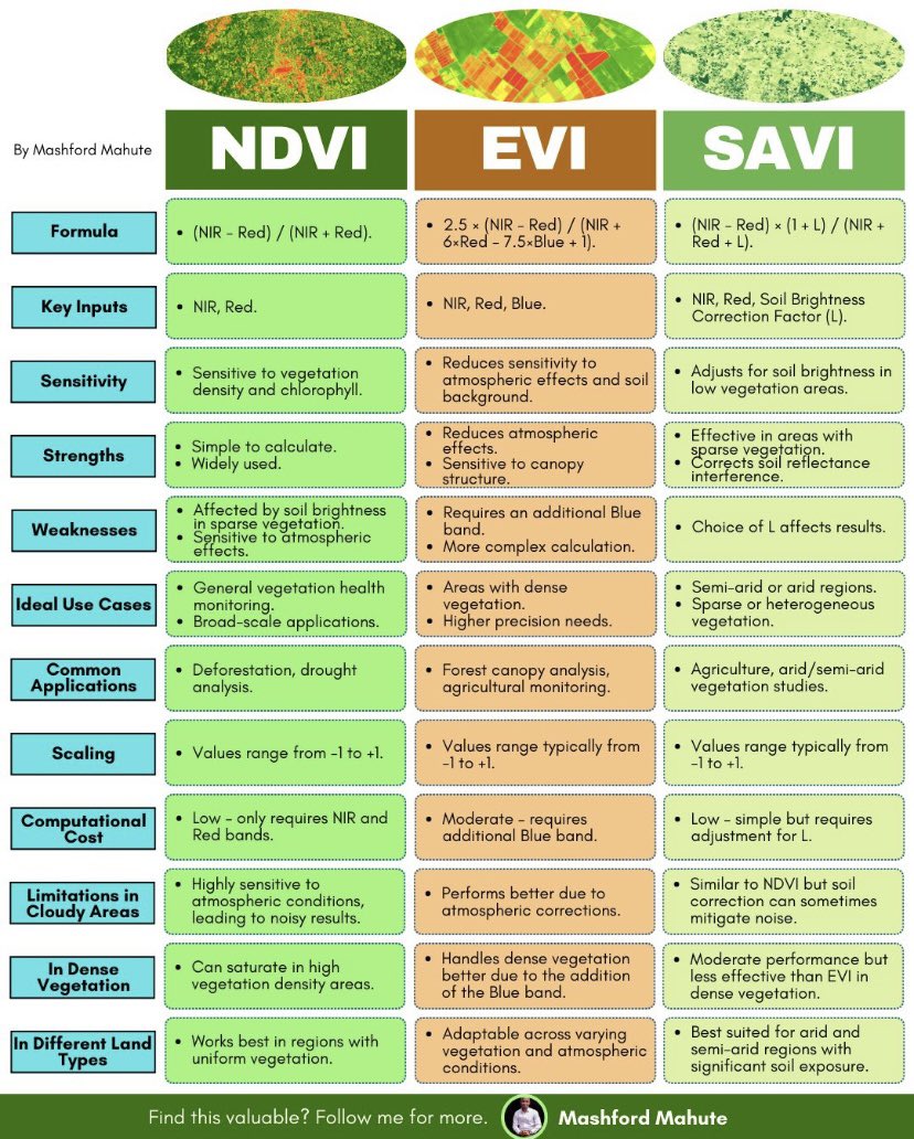
Vegetation indices [VI] are tools in remote sensing used to assess the health, density, and distribution of vegetation. Here are insights on three VI: • Normalized Difference Vegetation Index • Enhanced Vegetation Index • Soil Adjusted Vegetation Index 📸: Mashford Mahute

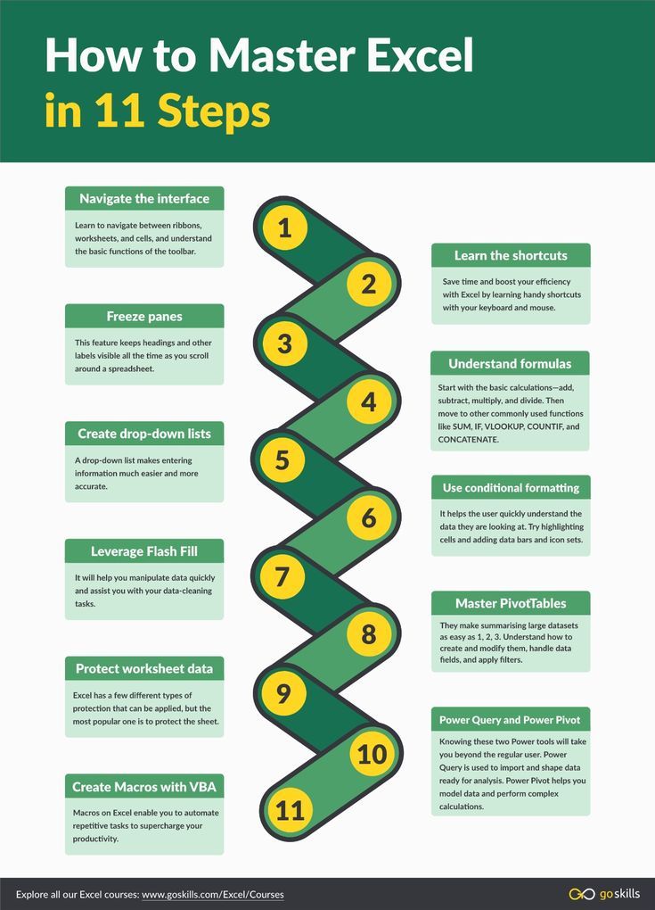
How to Master Microsoft Excel in 11 Steps #microsoftexcel #dataanalyst
The Basic Research Process Simplified 1️⃣ Identify a problem/question 🤔 2️⃣ Review existing literature 📚 3️⃣ Define your methodology 4️⃣ Collect & analyze data 5️⃣ Draw conclusions & interpret findings 6️⃣ Share your results! 🗣️ Research isn’t complicated—just take it step by step!


Thrilled to announce our collab with @ai16zdao! We're taking Aimonica to the next level by integrating the cutting-edge framework being developed on github.com/elizaOS This means adopting autonomous trading and leveraging their innovative marketplace of trust to shape…

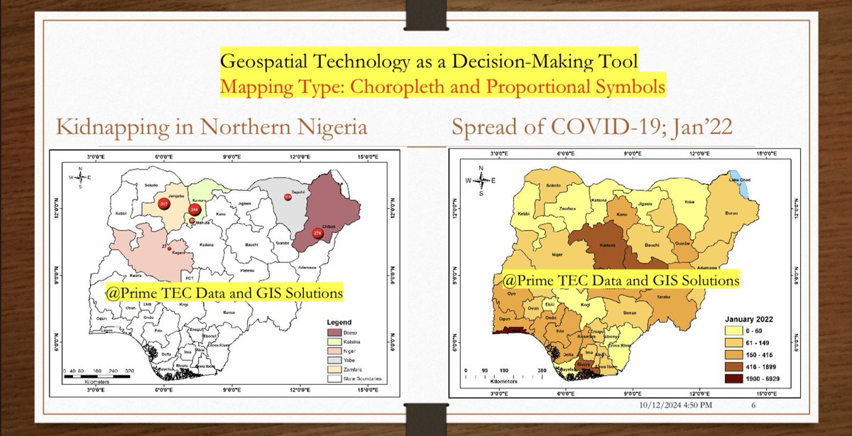
#GIS and various mapping techniques transforms complex data into actionable insights. These tools empower decision-makers to allocate resources, design targeted interventions, and address challenges in fields like climate adaptation, public health, and urban planning. #geospatial
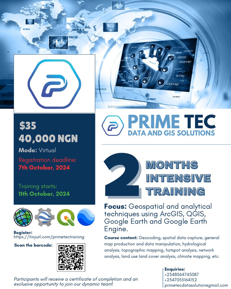
Hurry now! Today is the deadline for registration. Register for the two-month intensive training program on #GIS using a variety of software. ➡️ tinyurl.com/primetectraini…

Highlights from previous sessions facilitated training undergrad and postgrad students on methods of rainfall data acquisition: processing remotely sensed netCDF data to obtain rainfall parameters across AOI. You’re welcome to join us in the coming training. See details👇🏼


Highlights from previous sessions facilitated training undergrad and postgrad students on methods of rainfall data acquisition: processing remotely sensed netCDF data to obtain rainfall parameters across AOI. You’re welcome to join us in the coming training. See details👇🏼 https://t.co/w2TunBp1Lb

@PrimeTEC_data is hosting a GIS-focused training using Google Earth, QGIS, and ArcGIS, etc. 🚀 Applications in env. mgt., urban planning, agric, health, research, etc., to gain insights and make data-driven decisions! 🗓️💻📍See the flyer! Register: tinyurl.com/primetectraini…

We’ll be hosting a GIS-focused training using Google Earth, QGIS, and ArcGIS, etc. 🚀 You're in env. mgt., urban planning, agric, or research, GIS and remote sensing are powerful to gain insights and make data-driven decisions! 🗓️💻📍See the flyer! Reg: tinyurl.com/primetectraini…
Exciting opportunity to be skilled in GIS analysis using a range of software. Plug in here 👇🏼
Exciting opportunity to be skilled in GIS analysis using a range of software. Plug in here 👇🏼
We’ll be hosting a GIS-focused training using Google Earth, QGIS, and ArcGIS, etc. 🚀 You're in env. mgt., urban planning, agric, or research, GIS and remote sensing are powerful to gain insights and make data-driven decisions! 🗓️💻📍See the flyer! Reg: tinyurl.com/primetectraini…
Dimensions of features such as length, area, and perimeter are important parameters to measure for an accurate spatial analysis. youtu.be/nBYriP6L8c8?si…
Every map projection has its own distortion! Whether it's shape shape, area, or distance, no flat map can perfectly represent our round Earth. Learn how to carry out map projection in arc map. youtu.be/_L5-YgvQYdY #GIS #maps
Let's talk about GIS mistakes. One common mistake is not paying attention to data quality. Poor quality data can lead to inaccurate data analysis, unreliable results, and ultimately flawed decision-making. #GIS #data #Analytics
GIS can transform flood management in Lagos by facilitating data-driven policymaking, infrastructure planning, and emergency response. Embracing geospatial technology is crucial to building a more flood-resilient Lagos.


Colin Nikolaus @ColinN1445
6 Followers 297 Following Hello. I'm Joey. Hope you can follow me and become friends. https://t.co/kG7RzIDQSp
Rukia Technology @RukiaTechnology
2 Followers 49 Following Providing access to quality and affordable #ICT products & services.
Olapade Emmanuel @i_am_emzylee
142 Followers 465 Following God over everything! #Uite #Geographer #Geo-Spatialanalyst #GIS enthusiast #GGMU #OmoIbadan #Februaryborn


Ayotunde Aboderin @AyoAbord
500 Followers 3K Following YouthLED Integrity Advisory Board Member @UNODC | Youth Advisor @EUinNigeria | Country Lead @ImpactMun | Author |Educator | Climate & Anti-Corruption Champion |
Grado Adrian @Grado113760
16 Followers 256 Following If you get the chance to aim at the devil make sure you don't miss.
♣️ G.let'sCher �... @a_q_u_i_l_a
232 Followers 525 Following GIS - Sa†anis†🌐 Für dich, ich führ' dich 🗺️ My battery is low and it's getting dark⬛ никто не даст тебе новой попытки⬛ let's map this shit
Ndeso Rita @NRita98439
1 Followers 29 Following
100 Climate Messages @climatemessages
54K Followers 59K Following We need urgent, ambitious action on the climate. Without it, we’ll reach the tipping point and climate change will be unstoppable. Pass the message on.
Ayomide Ifedolapo OYE... @fedollsss
597 Followers 595 Following SEN Professional | Social Impact & Advocacy Storyteller | Disability Inclusion Advocate || ICFCWJ
peculiar @Iampeculiar_001
1 Followers 90 Following
ANTONY KATOI @KatoiAntony
2 Followers 25 Following
kemmy @Ekemini62565044
18 Followers 185 Following life is too short to spend time with people who suck your happiness out of you.
Opedimeji Rasak-Oyadi... @iam_razaaque
202 Followers 880 Following || Geospatial Analyst || Environmentalist ||Project Manager|| Experiential Marketing|| Lateral Thinker|| Team Builder|| Co-Founder @EmciAfrica
Go @golpz87
230 Followers 3K Following
Oluwatobi Olla @ollatobi
462 Followers 3K Following Urban Planner || GIS & RS Analyst || Business Consultant
Ìshọ̀lá @HabeebTeejay
126 Followers 506 Following Remote Sensing || Python || Product Designer || Geospatial || Dev || Data || Power BI || SQL || Opensource.
GIS World @gis_world1
665 Followers 2K Following GIS World is a leading portal dedicated to the Geospatial Communities.
Muhammad Imran @MImran97921485
23 Followers 920 Following Geologist From University of the Punjab,Lahore,Pakistan. Institute of Geology.

Emmanuel Eze @emmanueleze1900
2K Followers 4K Following Disaster Scientist | Dr. Rer. Nat. | Research Associate @uni_muenster | Educator👨🎓@unn_tweets |Christian @dclmhq |Husband |Father | Fr: @Scholarshipgen
Osasumwen @osasu_of_God
221 Followers 788 Following
MAVIS WANCZYK @mavis_43355
114 Followers 977 Following Thrilled to announce my $758m lottery win, and am giving out $15,000 with 1000 amazing followers - follow and Send a message with MAVIS I FOLLOWED YOU
Faith Chepchirchir @FaithChepchir15
118 Followers 495 Following
نظم المعلوم... @gis_eductation
13K Followers 5K Following | نشر المعرفة GIS | مؤتمرات | ورش_العمل | كتب | المنتديات| اعلانات | دورات_GIS | كتابة محتوى في مجال الجغرافيا و(GIS)🌐🌐 [email protected]
Abdullah Salim @AaOrg
107 Followers 1K Following بالدليل عنواني :شارع الصدق والامانة ، مدينة السلام، محافظة التسامح ، الدولة:سلطنة عمان.
Ojeniyi Janet @_GeoJanet
290 Followers 3K Following A Female Hydrogeologist| Groundwater Exploitation and Exploration |Borehole Drilling | Self Makeup Artist
Vanel Mudimbi @vanel_mud
796 Followers 2K Following Urban Planner l Designer and Social Innovator l Community Developer | Artificial Intelligence Propagator - World Bank consultant
The Lord's😎 @OSeunfunmiMich1
20 Followers 90 Following Eternal Life Seeker || UI Konnet || Content Creator || Poet || Educator || Gfx designer || CEO TheLord's network. I.G: @simply_seunfunmi Contact: 08078905767

Samuel Johnson O. @timmysamz
57 Followers 321 Following Resource surveryor, Construction manager, Geoscientist.
editaaine @editaaine
27 Followers 138 Following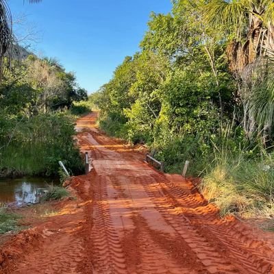

Africa's Exciting Net... @GISforAfrica
4K Followers 1K Following Building a better Africa for all through our community members, courses, events, investment plans, resource centres, geospecial consultancy, goods,and services.
SuperMap @SuperMap__GIS
7K Followers 5K Following GIS platform software and solution provider. Innovate Geospatial Intelligence, Elevate IT Value. #GIS #3DGIS #BigDataGIS #AIGIS #BIMGIS
Mary Inajoh @InajohMaryAlade
1 Followers 20 Following I’m a lady that simply trusts God for tomorrow because He holds the best for me.
FAWUMI ABRAHAM @FawumiAbraham
127 Followers 349 Following Not perfect but working hard to be better everyday, love meeting other lover of God
Geoscience Mapping So... @GMS_Mapping
3K Followers 3K Following GIS|Remote Sensing|Cartography|Survey|GIS Programming|Geodatabases Management|Data Science|YouTube Tutorials|Online and Physical Training
Omolola Adeyemi. O.| ... @Asa__bea
104 Followers 562 Following On-Page SEO Pro |Conversion Copywriter |Branding Content Writer |GIS-in-training |Building a Future in Smart Agriculture |ヲタク☯
Shreekant Bhandari @ShreekantBhand5
422 Followers 3K Following Geospatial, Geography, Educator🛰️🌐🗺️🌍 Lecturer.

Billal Sumon @BillalSumon8
71 Followers 302 Following #PhD Researchers #University of Sydney, Australia #University_of_Tsukuba, Japan #Precision Agriculture #Remote Sensing and Machine Learning
Black Geographers @blackgeogorg
6K Followers 3K Following Supporting the next generation of geographers and geoscientists

Fisayo @Thajadens_
1K Followers 2K Following GIS analyst 📍Baker📍ChelseaFC 📍Geography 📍M&E team lead &HRM @yattiyr_Init 📍Flood analyst @GeoharzardMaps || MTech @AFRIGIST_
Journal of Remote Sen... @Remotesens_gis
950 Followers 3K Following Remote sensing is the art and science of making measurements of the earth using sensors on airplanes or satellites.
Temitope @MapCarton
591 Followers 1K Following Cartography| Spatial analysis | Revenue| 3D Modelling enthusiast

Emmanuel Ajiboye @Sonofhumanity1
156 Followers 546 Following Creative Writer II Research Writer II National Socialist II Political Analyst II Economics Enthusiast II Bibliophile
Ayomide Ifedolapo OYE... @fedollsss
597 Followers 595 Following SEN Professional | Social Impact & Advocacy Storyteller | Disability Inclusion Advocate || ICFCWJ
Africa Youth Advisory... @AYAB_DRR
2K Followers 634 Following Official account of the Africa Youth Advisory Board on Disaster Risk Reduction (DRR) of @_AfricanUnion. Facilitating meaningful engagement of African Youth.
Geoscience Mapping So... @GMS_Mapping
3K Followers 3K Following GIS|Remote Sensing|Cartography|Survey|GIS Programming|Geodatabases Management|Data Science|YouTube Tutorials|Online and Physical Training
Africa's Exciting Net... @GISforAfrica
4K Followers 1K Following Building a better Africa for all through our community members, courses, events, investment plans, resource centres, geospecial consultancy, goods,and services.
Black Geographers @blackgeogorg
6K Followers 3K Following Supporting the next generation of geographers and geoscientists
Steven Ramage @Steven_Ramage
20K Followers 12K Following CEO @CEOSdotORG Committee on Earth Observation Satellites, Founder Réseau Consulting https://t.co/a9injevFpy Board @climatepolradar @GEOBON_org
USGS @USGS
779K Followers 93 Following Science is only a tweet away. Tweets do not = endorsement: https://t.co/VoRuucTNuK
Emmanuel Ajiboye @Sonofhumanity1
156 Followers 546 Following Creative Writer II Research Writer II National Socialist II Political Analyst II Economics Enthusiast II Bibliophile
Nigerian Airspace Man... @nigeriaairspace
10K Followers 683 Following Official X account of the Nigerian Airspace Management Agency (#NAMA), an Air Navigation Service Provider (ANSP).
NCAT, Zaria @NcatZaria
4K Followers 151 Following Official Page of Nigerian College of Aviation Technology. The foremost Aviation Training Institution in Africa and one of the best in the world.

NigeriaCAA @NigeriaCAA
25K Followers 86 Following Nigeria Civil Aviation Authority is the regulatory body for aviation in Nigeria. It became autonomous with the passing into law of the Civil Aviation Act 2006
Federal Ministry of A... @fmaviationng
55K Followers 689 Following The official Twitter handle of the Federal Ministry of Aviation and Aerospace, Nigeria. #AviationNG [email protected]
Jørgen Carling @jorgencarling
8K Followers 2K Following Research Professor and Co-Director of PRIO Migration Centre, working on global migration, transnationalism, immobility, visualization, research communication
Migration Research @SheffieldMRG
11K Followers 824 Following Research on global migration and mobility from the Faculty of Social Sciences Migration Research Group at the University of Sheffield.
International Migrati... @IMRjournal
12K Followers 1K Following A peer-reviewed publication on international migration, refugees, and population from @CMSnewyork Subscribe: https://t.co/LEPmHDHigL
ICMPD @ICMPD
11K Followers 794 Following The International Centre for Migration Policy Development (ICMPD) contributes to the development of better and safer migration policies and programmes.
Oxford Migration Stud... @OxfordMSS
6K Followers 127 Following Connecting people interested in #migration within & beyond academia through workshops, events and our annual conference.
Bureau of Conflict & ... @StateCSO
15K Followers 345 Following This account was retired on 6/6/2025 and is no longer in use.
Climate Ch. Migrants @CCMigrants
1K Followers 583 Following Climate Change Migrants - raising awareness of people who must abandon their homes due to climate change, and developing solutions to this global challenge.
Climate & Migration @CliMig
8K Followers 46 Following Climate change will re-shape patterns of migration. Everyone has the right to move safely and legally. A project by @ClimateOutreach Photo: Aji Styawan
FlowMaps @FlowMaps
52 Followers 11 Following BSC interactive dashboards for mobility associated risk related to COVID-19 in Spain. Maps, analytics and RESP API: https://t.co/mQgrSBA96j
Rely Services @RelyServices_
2K Followers 1K Following A global leader in Business Process solutions and services.
michael GOULD (@mgoul... @0mgould
11K Followers 3K Following I mostly use bloo sky now. #travel #mountainbike #internationalDev #GIS #Spain #sarcasm
Damian @spangrud
2K Followers 2K Following Family+ Maps + Food + Kites = me Director @ Esri and spatial geek (he/him)
Geoawesome @geoawesome_dgtl
25K Followers 6K Following Open and inclusive community platform for geospatial experts and enthusiasts. Building bridges across sectors and industries. All things GEO awesome 🌎 🛰🗺🚀
Sarah Bell @sarahbellmaps
11K Followers 1 Following cartographer • data visualization scientist • rock climber
🥔🗺️ ᴘᴏᴋ... @pokateo_maps
28K Followers 3K Following po-KATE-o, first of her name, eater of potatoes 🥔 and maker of maps 🗺️. I make GIS (more) fun by sharing maptastic themes & original mappy memes! 🌐 ᵛᶦᵉʷˢᵐᶦⁿᵉ
Sisters of SAR @SistersofSAR
10K Followers 4K Following A passion for all things #SAR | #WomeninSAR | @eoscenefrom | We 💜@LadiesofLandsat & @DamesofDrones| Tweets by @LDR1, @SAR_ahBanks, @Go__Pika & @ant_dasgupta |
Martin Stabe @martinstabe
16K Followers 6K Following Data editor @FT in London. These days mainly thinking about elections data and how to use automation and AI in news. Follow me in the other place. #ddj


TC Haddad @tchaddad
353 Followers 4K Following

John J Czaplewski @johnjcz
712 Followers 608 Following Maps, open source, software engineering, and occasionally finance
HERE Technologies @here
40K Followers 1K Following HERE, a location data and technology platform, moves people, businesses and cities forward by harnessing the power of location.
Google Earth @googleearth
1.2M Followers 289 Following Discover geospatial datasets and tools, AI capabilities, and planetary-scale insights from Google Earth, Google Earth Engine and Google Maps Platform
NatGeoMaps @NatGeoMaps
37K Followers 215 Following Since 1915, National Geographic Maps has been responsible for illustrating the world around us through the art and science of mapmaking.
Cris🛰️ @cavrinceanu
2K Followers 5K Following PhD @UoNgradschool NGI🛰 | Geospatial &Modern Slavery RF @RightsBeacon ⚖️| FOSS @OSGeo/@geospatialorg| Committee @GRSG_GeolSoc | Youth4Oceans 🌊|🇷🇴 in 🇬🇧
USGS Landsat @USGSLandsat
37K Followers 219 Following The Landsat Program is a series of Earth-observing satellites, co-managed by @USGS and @NASA. Delivering decades of Earth imagery, since 1972. 📡🛰️
Esri Conservation @Esri_Conserv
20K Followers 9K Following Official Twitter account of the Esri Conservation Team. Sharing the exemplary work of the global conservation community leveraging ArcGIS to save our planet.
Stephen Mather @smathermather
2K Followers 4K Following Mennonite—Pixel Shepherd & Direct Interhuman Pixel Transfusion @OpenDroneMap—https://t.co/3j0cBACuGZ—You know where to find me.

Dane Springmeyer @springmeyer
3K Followers 2K Following Mapper, programmer, climber. Engineering Manager of the Core Tech team @Mapbox
Ken Doman @raykendo
699 Followers 1K Following Husband, dad, Christian, INTP, geospatial dev, gate-opener, author, Regex fan, nerd collector, NG artificer, neurodiverse (he, him). Expressed views are mine.
Mamata Akella @mamataakella
2K Followers 789 Following Cartography @Felt. Been President @NACIS | Head of Cartography @CARTO | Web Cartography Lead @npmap | Cartographic Product Engineer @esri.
GeoEnable @GeoEnable
993 Followers 892 Following We are here to help you make sense of new technologies that leverage the power of location
Damien Saunder @DamienSaunder
1K Followers 2K Following Maps on Vinyl: An atlas of album cover maps out now. For US sales contact the Map Center, RI. For AU sales, visit your local book store or Amazon.
Alasdair Rae @undertheraedar
44K Followers 4K Following Maps, stats, data, cities, density, elections, gifs, geo + QGIS training with Map Academy - founder of Automatic KnowledgeTrends for United States
You might like