
Southern Mapping, a Woolpert Company @SouthernMapping
World leaders in Aerial Surveying and Airborne Remote Sensing. southernmapping.com RSA, Tanz, Bots, Moz Joined December 2012-
Tweets342
-
Followers321
-
Following291
-
Likes11
Southern Mapping, a Woolpert Company, provides precision vector mapping from highly accurate #lidar and #orthoimagery as well as #satellite imagery. #mapping #survey #geospatial
From 2007 to date, Southern Mapping, a Woolpert Company has successfully completed over 50 projects in the #democraticrepublicofcongo! Southern Mapping continues to serve this great country with rapid delivery of the highest-quality #mapping. #aerialsurvey #geospatial

Program Directors Jannie Engelke and Nivara Pillay at The #CESAIndaba! The event brings together leading technical #engineering experts from #government entities, contractors and suppliers. Southern Mapping is a @woolpert Company. #Infrastructure #mapping #geospatial

A Beautiful capture of The #SaulspoortDam in Bethlehem (Free State), depicting the Normalized Difference #Vegetation Index (NDVI) of the area. #landsat 8 data available from the U.S. Geological Survey. Southern Mapping is a Woolpert company. #imagery #mapping

“We are what we repeatedly do. #Excellence, then, is not an act, but a habit.” Aristotle. Our #DRC #dreamteam ready for the day! #lidar #mapping #teamwork Southern Mapping is a #Woolpert Company.

Another Day Another Survey! July 2022 stats show 1408 projects completed in 48 countries - a great accomplishment for all our teams! Southern Mapping is a Woolpert Company. #aerialsurvey #mapping #woolpert #numbersworthknowing

Woolpert is recognized as a Great Place to Work by its employees and is America’s fastest-growing #AEG firm. Southern Mapping, a #Woolpert Company, has career opportunities available in our Operations Team for an Aerial Sensor Operator! lnkd.in/dQJKk237 #jobalert

The #BlydeRiverCanyon is a 26km long Canyon located in #Mpumalanga, #southafrica. It is the one of the larger canyons on Earth. Beautiful Survey Day! Southern Mapping is a #Woolpert Company. #Lidar #viewfromthetop #mapping

"There is only one job in this world that gives you an office in the sky; and that's a pilot." - Mohith Agadi. Another day another successful survey completed! Southern Mapping is a #Woolpert company. #LiDAR #mapping #pilotlife #aerialsurvey


Southern Mapping, a Woolpert Company, exhibited at the #Forestry #GIS & #remotesensing Conference in May; to highlight the importance of GIS and Remote Sensing Technologies, and to outline their applications. Read more about our GIS capabilities here: lnkd.in/dy5BmGdq

SPOTTED! Southern Mapping, a Woolpert Company, was involved in discussions with The Office of the Surveyor-General of #Nigeria, regarding the planning of a large-scale map of the entire country. Read the full article here: lnkd.in/dYiQRxjj #mapping #aerialsurvey

#viewsfordays! The Lower Steenbras Dam, is a gravity concrete arch type dam located above Gordons Bay, near #CapeTown in #SouthAfrica. It is one of the six large #dams that make up the #WesternCape Water Supply System. Southern Mapping is a #woolpert company. #aerialsurvey #maps

We are at #nampo2022! Located in the main Nampo Hall at Stand 81 - Jaco Wiesner, Geospatial Program Director, is manning the booth and offers various #geospatial and #remotesensing solutions for the #agriculture sector. Southern Mapping is a #woolpert company.

Last day of #miningindaba2022 ! Credo Unamaka, Geospatial Program Director, pictured below. Credo is our go-to-guy for #tailingsmanagement, #remotesensing, #hyperspectral analysis for #exploration, #environmentalmonitoring and mining change analysis. #mining #lidar #woolpert

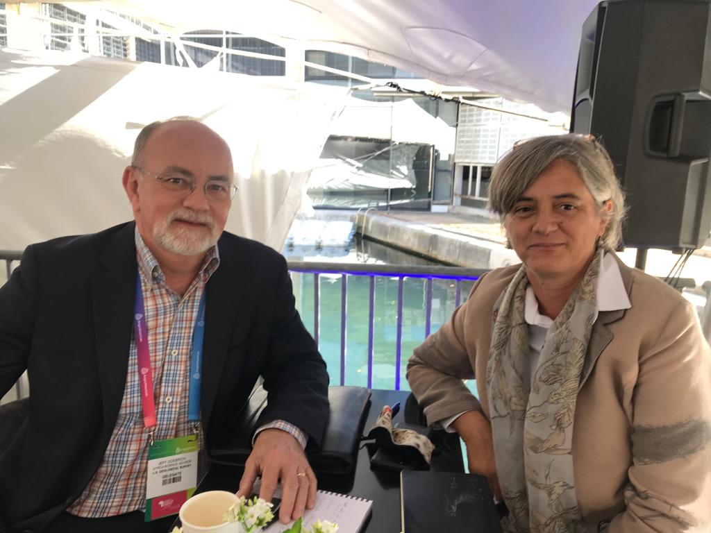
Day 2 of #miningindaba! Cecilia Hattingh, Geospatial Program Director and Jeff Doebrich, from the U.S. Geological Survey (USGS). Our #surveytechnologies assist the #USGS to provide science to develop new methods and tools to enable information about the Earth and its processes.
Only 4 days to #miningindaba 2022! Our team of specialists will be attending this event next week, at the #CTICC in #capetown, offering a wide range of #geospatial solutions to the #miningindustry. Southern Mapping is a Woolpert company. See you there! #mappingforminingindaba

What an adventure! On site in #Zimbabwe conducting a #remotesensing spectral investigation, that forms part of a ground truthing exercise related to a multispectral analysis, for an #exploration client. #spectrometer offerings here: southernmapping.com/spectrometers/

SPOTTED! Future #aerialsurvey #pilot in training, Baby Connor Bosman - (pictured below) - going to work with Dad is just "plane" fun! Southern Mapping is a Woolpert company. #babysteps #lidar #Woolpert


Someniam @Someniam1
838 Followers 5K Following ♍|19|Eng/Esp I like drawing, gaming and watching movies. Hope you all enjoy my content.
Golota Isaac Lamah @GolotaIsaac
63 Followers 704 Following Father | Husband | Senior Environmental and Sustainability Specialist
Oleg Chaplygin @OlegChaplygin
2 Followers 18 Following
Anthony Britz @AnthonyBritz98
2 Followers 15 Following
Wilmich Wessels @WilmichW
5 Followers 37 Following
regiser @Iamregiser
48 Followers 3K Following
Joseph Seppi @joseph_seppi
0 Followers 2 Following
Nishant @jainnishant123
155 Followers 614 Following well m very frank n obiviously daring.i luv adventure,nature,music...... i m smart,trendy bt on the other hand very simple....
Love 🤍🌻 @Bongeka___
4K Followers 2K Following ⚒👷🏾♀️•Nature •Mental Health • Lover. Arsenal FC . Travel. ESG enthusiast .
Woolpert Africa @WoolpertAfrica
14 Followers 2 Following Woolpert Africa brings together three of the world's leading geospatial firms: Woolpert, Southern Mapping Company and AAM

America's Engineers @AmericasEngine1
96 Followers 337 Following America's Engineers: The People, Programs, and Projects of the U.S. Army Corps of Engineers. This is not an official DoD, U.S. Army, or USACE account.
GW Consulting @gwinsights
143 Followers 418 Following GW Consulting, the market research and consulting division of @geoworldmedia, provides impactful insights to commercial, public, and social sectors.
Prajwol Babu Subedi @prajwolsubedi15
38 Followers 256 Following
नाम किन �... @naamkinachahiyo
441 Followers 3K Following A thorn around the flowers. I tweet what my brain puke. On a continuous D*Evolution. onlymemes #AltAC
Tshepie @Otshepe39772665
9 Followers 109 Following
PASCO Corp. Satellite... @pasco_sat
122 Followers 182 Following @PASCO9232 distributes #SatelliteImageries and data observed from #ALOS series under permission of #JAXA since 2011. #ALOS2 #ALOS4
Black and Opinionated @OpinionatedBlaQ
106 Followers 867 Following Don’t take it personally...#justsaying
Mtombo @mhizhampc
271 Followers 2K Following

Phemelo Mahamutsa @Hope_Mahamutsa
3 Followers 25 Following Bsc Environmental Science student, BSc Hons GIS & remote sensing 🗺. environmental conservationalist. Climate action hun 🌱💪🏾 #witsie ♥️
love_secret @lerato_sephiri
41 Followers 222 Following
Eric Muncy @Mapping_Guy
167 Followers 919 Following
EU Global Action on S... @EUGlobalSpace
754 Followers 958 Following Official account of the EU Global Action on Space. This does not reflect the views of the European Commission and/or any other body of the European Union.
Geosun Navigation @GeosunNav
1K Followers 4K Following Make the LiDAR/SLAM solution more affordable and applicable.


AAM, a Woolpert Compa... @AAMGroup
906 Followers 556 Following AAM is now fully integrated into @Woolpert! Please follow us at @WoolpertAPAC for the latest projects, news, & perspectives specific to the region.
Noluthando Ndlala @NdlalaNolu
378 Followers 1K Following GLOW-GETTER✨💛👑 Siphesihle's mom 🤱🏽 Geographic Information Systems Graduate👩🏽🎓 MSc📚🌍💧
Myles Sutherland @MylesSutherland
2K Followers 3K Following Kiwi, geographer, and surfer. working on ... GeoCam

Stix Mthombeni @Benele_sd
18 Followers 133 Following
Pinkmatter Solutions @pnkmttr
25 Followers 13 Following Pinkmatter Solutions is a leading Earth Observation software company servicing the global market.
Eduardo Freitas Olive... @eduol
445 Followers 2K Following Entusiasta Geo/Drones (Imagem de capa: Carina Nebula NIRCam Image - Telescópio Espacial James Webb)
Bhawana Farswan @BhawanaFarswan
0 Followers 12 Following
Tima Fz @TimaFzz
0 Followers 21 FollowingLerako Naphtaly @LerakoN
217 Followers 2K Following New Creature IN Christ | Husband | Father | Entrepreneur | Fighter
ASHITA VOHRA @AshitaVohra
10 Followers 195 Following
Christopher Beddow @cbed32
2K Followers 2K Following #openstreetmap #mapillary #gis #rapid 😎 Map Building for #AR @ Meta 🗺️ 📍Montana 🇺🇲 ➡️ Schwyz 🇨🇭 🌎 Voyager, language learner, writer, mapmaker, skier ⛷️
MarginalLands @MarginalLands
490 Followers 2K Following Identifying Marginal Lands in Europe and strengthening their contribution potentialities in a CO2 sequestration strategy
Przemyslaw Zelazowski @satagro_ceo
54 Followers 165 Following CDO and founder of SatAgro - an online service turning satellite-led precision agriculture into common practice. Oxford graduate.
Gilbert Mwang'ombe M @MGilleyM
742 Followers 2K Following KMMREC -Marine Mammal Program Manager | Scuba diver | Adventurer | Drone Pilot
HA Ag Solutions @haagsolutions
2K Followers 3K Following Navy Veteran. Precision Ag Specialist. Satellite Imagery. VR Prescriptions. Whiskey Drinker. Golf Hack.
amal smida @amalsmida1
0 Followers 4 Following
McNally Patirishu @MacNallie
217 Followers 658 Following Geospatial Analyst | Tech Enthusiast | Data Scientist | Ideation |#LocationIntelligence | #GoalKeepers
Adeoye Durodola @adeoye_durodola
80 Followers 2K Following
Ahmɑd @Ahmadjalil92
426 Followers 3K Following A Coffeeholic Geographer 🗺 interested in 🪐 📸 & Good Food🍴
Claire Mudge @ClaireMudge
152 Followers 1K Following
YUNIVERSE AVIATION @YUNIVERSEAVIAT1
21 Followers 127 Following We are one of the world’s leading developers and manufacturers in the field of UAV autopilot systems.
Nancy Graham @LP360_GIS
46 Followers 113 Following Operations Manager of GeoCue Group. GeoCue offers software, hardware, training and support for airborne and drone LIDAR.
Woolpert Africa @WoolpertAfrica
14 Followers 2 Following Woolpert Africa brings together three of the world's leading geospatial firms: Woolpert, Southern Mapping Company and AAM
Przemyslaw Zelazowski @satagro_ceo
54 Followers 165 Following CDO and founder of SatAgro - an online service turning satellite-led precision agriculture into common practice. Oxford graduate.

ReliefSouthSudan @RelSouthSudan
301 Followers 453 Following Seeking to educate and empower South Sudan's refugees.
Thor Explorations @ThorExpl_THX
1K Followers 84 Following Operating Nigeria's 1st Large Scale Gold Mine and Advancing High Value Gold Projects in Nigeria and West Africa.
Charlie Wymer @Charlie_Wymer
265 Followers 993 Following Current building services engineering MSc student at Loughborough University. Buildings, technology, and science; that's my jam. Can also be spotted cycling.
Mark Coote @CooteMR
4 Followers 40 Following
Geospatial Now @geospatial_now
2K Followers 976 Following Interested in #Geospatial News? Install Geospatial Now from play store. #remotesensing #drones #gis #lidar #mapping #geospatial #AI #gps
Kerry-Ann Harriott @gisgeek2018
320 Followers 336 Following Chevening Scholar 20/21| GIS Professional | Environmentalist
City of Cape Town @CityofCT
448K Followers 1K Following The City's social media is online from 07:30 - 16:00 Monday - Friday and 12:00 - 14:00 on Weekends and Public Holidays.
ᑕᗩᑭE TOᗯᑎ @CapeTown
373K Followers 55K Following Curated Cape Town since 2007 | Fiercely Independent | Conversational @iAmnotMany - Entrepreneur & Digital Content Strategist - Limited Promos - Ask me🕯⁽ᴰᵉᵉ⁾
GRSG @GRSG_GeolSoc
1K Followers 562 Following The Geological Remote Sensing Group (GRSG) is a special interest group of the Geological Society of London, @GeolSoc, and the @RSPSoc.
PositionIT magazine @positionitmag
200 Followers 887 Following Southern Africa's leading geospatial magazine, covering geoinformatics, surveying, GIS, BIM, mapping, location intelligence and related spatial applications.
lidarliam @lidarliam
143 Followers 636 Following
Simon Kuestenmacher @simongerman600
258K Followers 216K Following German #geographer and #demographer in #Melbourne. I curate #maps and #data that explain how the #world works. Obviously all opinions are my own...
Building Information ... @BIMinAfricaConf
219 Followers 96 Following Today’s BIM champions are tomorrow’s industry leaders
ExceptionalBIM @bim_baron
1K Followers 1K Following Building impactful mentoring programmes will be a key pillar of success within our built environment
El uso de los SIG en ... @VILCHIS_MX
207 Followers 3K Following La aplicación geomática para el desarrollo sustentable, SOCIEDAD, ECONOMÍA y MEDIO AMBIENTE.
Evomatix @Evomatix_
141 Followers 981 Following Evomatix offers #Advisory, #Support, #ProjectManagement and #GeospatialServices to best suit your #BuiltEnvironment needs.
E Kruger-Franck @elmariekrgr
60 Followers 213 Following PhD Candidate MSc Environmental Management Graduate - Wetland/Aquatic Ecology and Biodiversity. Lover of Nature and the outdoors.
Jason Holman @JasonHolman88
2 Followers 87 Following
Wingtra @Wingtra
3K Followers 920 Following Meet WingtraOne: the professional VTOL drone for mapping & surveying
john klassen @johnklassendte
36 Followers 169 Following
Geomatics World @GeomaticsWorld
821 Followers 489 Following Geomatics World is the leading journal for professional and techically qualified surveyors.
Kevin Corbley @GeoBizDev
1K Followers 4K Following Business Development, Marketing Communications & Content Creation for Geospatial, Mapping, Energy, Aerospace, and Related High-Tech Organizations.
NUBIGON @NUBIGON_INC
772 Followers 676 Following Next-gen #pointcloud visualization and animation for #laserscanning and #photogrammetry professionals
Kongo Libre @Kongo_Libre
642 Followers 707 Following #Thinktank des libres-penseurs #Congo _lais. Mode solution par la construction des Institutions. #Factcheck #democratie #politics #economie .RT is NOT endorsmt
Mostafa Sadeghnejad @MostafaSadeghn3
674 Followers 1K Following Geography PhD candidate @kstate_geog |MSc of GIS and Remote sensing | President of Gamma Theta Upsilon - International Geographical Honor Society @KState
Marjorie Ferrone @MarjorieFerrone
18K Followers 16K Following | 27 | CoFounder and COO of @DroneParks | Proudly a female Tech founder | Former Naval Academy midshipwoman | NEVER underestimate a strong lady #DroneParks
January Makamba @JMakamba
1.2M Followers 2K Following
Mark Summerton @Mark_JGAfrika
1K Followers 4K Following Building partnerships, evidence and action to leave no-one behind in a climate resilient future #water #resilience #sanitation #SDGs (views are my own)


Max Korir @korir_max
115 Followers 1K Following
David Nolan @djnolan22
11 Followers 95 Following
Alexis Vizcaino 🌋 @EditorGeo
3K Followers 3K Following This profile has been in standby mode since November 2024 to prevent Elon Musk from profiting off his toxic, neo-fascist political positions.

SlidX @SlidX_Drone
836 Followers 2K Following SLIDX is a North American company founded in January 2015, headquartered in Montreal. SLIDX team have invented a new generation of 100% electrical drones
Bush Journalist @spinosaspider
1K Followers 341 Following Online digital publisher of educational, entertaining and interactive media that brings the magic, majesty and mystery of the African bush to life.
ARK - Access Research... @ArkGroupCo
530 Followers 1K Following ARK group is the leading scientific networking website, offering top scientific trending information and foremost events and webinars.
Roxanne @roxanne_munsamy
69 Followers 120 Following Ecology/ GIS Scientist Choose to see the beauty in life. Live to make a change. 🐝🌲🌸🌰🌈🌞
Simon Cook @SimonIanCook
4K Followers 4K Following (Mostly dormant - but do email me) Runner & Human Geographer @BCUHELS interested in active mobilities, sport & physical culture.
Grant Grabe @GrabeGrant
1K Followers 5K Following Entrepreneur & networker of note in Africa - Owner Indusquip WEM INVT - Electric Motors & AC Drives
OCEAN 3 D projects @OCEAN3Dprojects
1K Followers 3K Following OCEANs3D=Digital Depth Data (&in3D) from OCEANS' ECOsystems & Navigation's Data:Lon&Lat& Depth+Bathymetry+Hydrography+OCEANS'seabed's OCEANography = in 3D

Citizen Science GIS @Citizen_GIS
2K Followers 3K Following Connecting science and society with GIS and drones 🌎
Bani Geopark @BaniGeopark
354 Followers 1K Following
Mike Miller @millermountainl
2K Followers 3K Following GIS Nerd, Conservation Biology, Open Source Web Mapping, Leaflet, PostGIS, TurfJS, Merging conservation and GIS to make the world better https://t.co/51EOjt5kuU
GeomaticsIndaba @GeoIndaba
409 Followers 2K Following The Geomatics Indaba is a fully-inclusive geomatics sector conference.
Sascha Brunner @GISmountains
1K Followers 776 Following Loves all about geospatial, location, spatial data, maps, mapping, cartography, developing, 3D..... Product Engineer - ArcGIS 3D Javascript API at @esriTrends for United States
You might like


