Where Geospatial Media @WhereGeospatial
We wish to build a geospatial community that networks all geospatial professionals to provide peer-to-peer support. wheregeospatial.com Joined September 2018-
Tweets21
-
Followers119
-
Following72
-
Likes242

I’ve been with @Esri for almost 10 years now. Grew up around maps, went to school for #GIS, and love the #Esri family I am apart of. We welcome all. esri.com/en-us/about/ca… #mapbox #GISchat #GIScareers

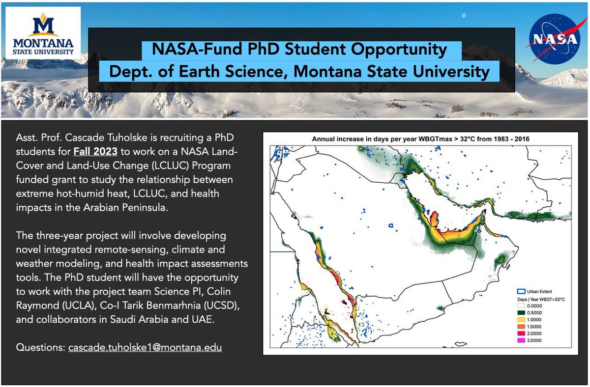
#PhD position to explore land-cover and land-use change, climate/weather, and extreme hot-humid heat impacts on human health and well-being in the Arabian Peninsula in the Earth Sciences Dept. at Montana State University-Bozeman. ⏰Deadline is Jan 15 🔗lnkd.in/gARTSUJS
We're 🔭 for an #organizationalstrategy / #organizationalchange consultant to work with us on our operating model. 👉 hotosm.org/rfps/redefinin… HOT has grown to over 100 staff in 37 countries, and we're looking for an adaptable Operating Model that evolves with our Strategy.

Are you a business development professional with experience in relationship building and securing donor funding? Check out this new and interesting role at the Open Mapping Hub – Eastern and Southern Africa. hotosm.bamboohr.com/careers/117 Monday is the last day to apply! #remotejobs

The @osmuganda support of the Ugandan Ebola response is ongoing, and you can help out this #ValidationWeekend by mapping and validating in project 13718: tasks.hotosm.org/projects/13718. This mapping is beginner accessible. Thank you for your support!

Follow these steps to make your own map of current drought conditions in a minute (or less) in #ArcGISOnline, using @LivingAtlas content. esri.social/f3wr50K3Ss3

#MostCited #remotesensing Land-Use and Land-Cover Classification Using a Human Group-Based Particle Swarm Optimization Algorithm with an LSTM Classifier on Hybrid Pre-Processing Remote-Sensing Images by Ganesh B. Rajendran, Uma M. Kumarasamy, et al mdpi.com/2072-4292/12/2…

Happy to introduce our speakers for the Remote Sensing Day Event! Join Boineelo Moyo, ZouElFicar Zaiter, Omoniyi Ikuomola and Sujata Das as they present some of their incredible projects. Haven't registered yet? Here is the link : linkedin.com/posts/where-ge…

HOT is hiring! We are looking for a Tech Senior Product Designer who will be involved in every aspect of our product development process from early conception to the final launch. For more details and to apply 👉 bit.ly/3oAdRyS #techjobs #humanitarianjobs #remotejobs

Create a map in a minute! ➡️ Learn how to map smoke and air quality using #ArcGISOnline and @LivingAtlas content: esri.social/qyK150J6Xkz

Already in the weekend mood? Don't forget to sign up for Where Geospatial Remote Sensing Day event! Get ready for exciting presentations by experts from different parts of the world! Register now! lnkd.in/dj6Zy2j6 #satelliteimagery #remotesensing

📣Call for Presentations: Esri Ocean, Weather, and Climate GIS Forum. Join our collaborative science community to share advances in data collection, analysis, and our understanding of climate and ocean interactions. 🌍 Deadline to submit Aug 14. esri.social/GXEO50K7y9u

Join @osmafrica's Monthly Mapathon! The August edition will be hosted by the #OSMRwanda community. The event takes place on 6 August, 12 -3 UTC. Open to all mappers! Register here 👉bit.ly/3BwVbYf @openmapping_esa @osm_Rwanda

📢 We are thrilled to announce that State of the Map Africa 2023 will take place in-person in Yaounde Cameroon🇨🇲, on December 6-8, 2023🗓️ Save the dates! #sotmafrica2023

Are you excited to share your work using Remote Sensing technology? Then this is an excellent opportunity for you. Submit your abstract to be considered for a 15-minute presentation at the Remote Day Seminar on August 13, 2022! lnkd.in/dQtTJQjj
Who are we, and what do we do? Get to know us! youtu.be/Jsl5NxQxDAI

Looking to learn more about the Landsat 9? The Data Users' Handbook is available via the Landsat Missions Website. Access it here: ow.ly/5Ugb50IKHWt

New #LandsatHeadline! The @USGS Global Visualization Viewer (GloVis) has been updated to add Landsat Collection 2 and include Landsat 9 scenes. 📰: ow.ly/ef4M50Jzn5A

Where Geospatial and Where Geospatial Media are back again with amazing geospatial content! Anything GIS and Remote Sensing? We might have a solution for you!
A friend call this the Marriage between Clinical research and GIS How technology is building 'cancer maps' to understand tumours | London Evening Standard - standard.co.uk/futurelondon/h…

Samuel Nyarko @peniel144000
3 Followers 120 Following University of Ghana Geospatial technologies enthusiast Astronomy learner
Emmanuel Hughes @emmanuelalexhu1
77 Followers 374 Following GOD first🙏 Geomatic Engineer Believe,Achieve and Conquer
OpenStreetMap Ghana @OSMGhana
2K Followers 467 Following Community of volunteers growing @OpenStreetMap in #Ghana and beyond. Join us today!

Confidence Kpodo @Aku_Sedodo
937 Followers 859 Following GIS|YouthMapper|UCC|Bookworm|Student of Life|Geo-heart.
Francis Acquah @Francis58254994
24 Followers 120 Following
GeoDAJ Consultants @GeoDAJ_Ltd
1K Followers 1K Following GIS|| Remote Sensing|| Land Surveying|| Cartography|| Web Mapping|| Environmental Impact Assessment|| Building and Construction||
🇧🇿 Belize GEO �... @BzGEO
10K Followers 7K Following Belize GEO: Belize Group on #EarthObservation & GIS. #SciComm re: EO, GIS relevant to #Belize, the #Caribbean. Administered by a real live Belizean scientist.
#gischatbot @gischatbot
4K Followers 4K Following A friendly bot from the GIS community! Developers: @jeafreezy & @adiguntoba Killed by Twitter API. Now moved to Mastodon. Supported by @NickBearmanUK
Diana Yator @DeeYator
105 Followers 423 Following Educator|| Psychological Counselor||Humanitarian|| Mental health advocate|| Behavior Change Communicator|| Environmentalist|| Event Organizer|| Wife|| Mother
GeoEnvtech Consulting... @Geo_envtechtz
184 Followers 256 Following GECS is a Tanzania based modern firm, employing Geospatial Technologies , GIS, RS, Web Mapping, Geo Apps, Data Collection & Analysis, EIA &Audit. REG# 489331
michael attah nyarko @attah_mn
2 Followers 268 Following
Milcah Kamanga @MilcahKamanga
1 Followers 29 Following
UNIMA YouthMappers @UNIMAYouthMapp1
49 Followers 55 Following We dont just build maps, we build Mappers. #UNIMA
MUST YouthMappers @MUSTYuthmappers
128 Followers 112 Following We don't just build maps, we build mappers.
Tiya mwathunga @TMwathunga
20 Followers 51 Following A disciple of Christ, daughter, sister, friend ❤️ and an aspiring geologist ☺️
IMAP INTERNATIONAL L @iMAPIntlKE
1K Followers 2K Following We are a market leader in offering Geo spatial services. Our niche cuts across GIS/RS services, Web-mapping, Urban planning, Land Survey, among other Services.
faith cherotich @faithchero96
16 Followers 155 Following
Otoo Augustine @OtooAugustine1
33 Followers 127 Following
Geoscience Mapping So... @GMS_Mapping
3K Followers 3K Following GIS|Remote Sensing|Cartography|Survey|GIS Programming|Geodatabases Management|Data Science|YouTube Tutorials|Online and Physical Training
Kadiri Geospatial Sys... @KadiriGeo
514 Followers 286 Following Land & Engineering Survey, GIS & Remote sensing, Cartographic mapping.
DroneLabs @DroneIndustries
9K Followers 5K Following It's Maritime Heritage Week. Sharing very large files online? DroneLabs is the easiest way to manage, send & share very large images with your visitors.
SuperMap @SuperMap__GIS
7K Followers 5K Following GIS platform software and solution provider. Innovate Geospatial Intelligence, Elevate IT Value. #GIS #3DGIS #BigDataGIS #AIGIS #BIMGIS
OSM South Sudan @OSMSouthSudan
993 Followers 1K Following
Spatial Ventures @SVL_Kenya
653 Followers 3K Following SVL provides open source Geospatial solutions and services to private enterprises and to Government entities; enabling the transition to open source GIS
ACCGIS @ACCGIS
517 Followers 891 Following Steven Hills, 🇨🇦 GeoEducator, GeoMentor, GeoEnabler & GISpatialist Environmental Technologies Program 🌐 49.8409,-99.9186 Opinions are my own!
Nse-Abasi Ayara @AyaraNse_Abasi
301 Followers 3K Following 2024 Ecological Security Fellow @CSRisks || Nuclear Security || National/International Security || CBRN. Advocating for nuclear security through @nuclear_Aware
OpenStreetMapKE @OSMKenya
2K Followers 927 Following We are a local community of individuals and organisations contributing to, using and advocating for @openstreetmap in Kenya. #OSMKenya #MapKenya #UnmappedKenya
Rabia Munsaf Khan @MunsafRabia
607 Followers 548 Following Remote Sensing Specialist | Fulbright Doctoral Candidate | IEEE GRSS | IEEE CSTF | Gold Medalist (BS & MS) | Data Scientist | Machine Learning | Water Quality
Dr Adingra @pacomadingrah
600 Followers 436 Following SIG &Teledetection, Geomatique Libre, Open-data, Data-Management #OpenstreetmapCI, #Youthmappers Community Mapping
@Kantolobo @Kantolobo
31 Followers 550 Following Drone specialist, GIS, and Remote Sensing specialist, Researcher and Spatial Analyst, Kantolobonian
MICKY ッ @mr_mickson
7K Followers 5K Following
Adim Ijeaku Jane @jane_adim
89 Followers 272 Following Forester|GIS analyst|Environmentalist|Sustainable Forester|Bee-keeper|Wildlife enthusiast

Pablo Ramirez @pabloramirez_SB
176 Followers 922 Following Vivo en Santiago 🍀 amo mi familia 👨👩👦👦 alguna vez seré un #tedtalk speaker 🎤 Creador de The Achiever (newsletter)

Francis Asante Nsiah @Nsiah_Asante
82 Followers 294 Following #Quality Assurance, Agile & Scrum , API Testing, Cypress #GIS Analyst, Geography, OpenStreetMapper, Cartography, Geospatial #GhanaianSignLanguageInterpreter
Frank Awuah-Antwi @FrankAwuahAntwi
21 Followers 191 Following


Michael Holarli @MichaelHolarli
87 Followers 404 Following Life is all about finding calm in the chaos.🤓🥰
Augustine @August_Adom
119 Followers 380 Following God is Good❤ GIS Analyst Remote Sensing Analyst God's Favorite
Eguagie-suyi Precious @EguagieSuyi
34 Followers 227 Following Atmospheric science student | spatial analyst| data scientist| Christian| Fashion designer | Jesus |

Spec @SpectrumBamfo
1K Followers 2K Following Geomatic Engineer 👷🏾| Drone Pilot 👨✈️| Messi Fan | G🌎S
Samuel Osei Kofi Osaf... @phrickysam
5 Followers 52 Following
Ladies of Landsat @LadiesOfLandsat
11K Followers 5K Following ALL are welcome! | #STEMinism | We 💜 @SistersofSAR, @WomenofWaves & @DamesofDrones! | Website coming soon!

Ocansey 🌍 @nene_kartey
551 Followers 2K Following ||BA. Geography (GIS, RS & Disaster Management)|| Msc Engineering Urban Planning and Management ||Bohemian|| ||Ominist|| 🇬🇭🌍 #MUFC🔴
Boineelo Moyo @BoineeloMoyo
62 Followers 282 Following Ice cream 🍨is cheaper than therapy & also 🤦🏾♀️ my brain has too many tabs open.
Open Geospatial: OGC @opengeospatial
27K Followers 230 Following OGC’s member-community of experts makes location data Findable, Accessible Interoperable, and Reusable (FAIR) through #innovation #collaboration and #standards
Geospatial World @geospatialworld
33K Followers 3K Following Your trusted knowledge source for all things geospatial. We delve into tech convergence and pivot to Industry 4.0 via Digital Transformation and Sustainability
Esri GIS Education @GISEd
21K Followers 685 Following Esri GIS Education - news, curriculum, software, tools and more
🇧🇿 Belize GEO �... @BzGEO
10K Followers 7K Following Belize GEO: Belize Group on #EarthObservation & GIS. #SciComm re: EO, GIS relevant to #Belize, the #Caribbean. Administered by a real live Belizean scientist.
GeoDAJ Consultants @GeoDAJ_Ltd
1K Followers 1K Following GIS|| Remote Sensing|| Land Surveying|| Cartography|| Web Mapping|| Environmental Impact Assessment|| Building and Construction||
#gischatbot @gischatbot
4K Followers 4K Following A friendly bot from the GIS community! Developers: @jeafreezy & @adiguntoba Killed by Twitter API. Now moved to Mastodon. Supported by @NickBearmanUK
ACCGIS @ACCGIS
517 Followers 891 Following Steven Hills, 🇨🇦 GeoEducator, GeoMentor, GeoEnabler & GISpatialist Environmental Technologies Program 🌐 49.8409,-99.9186 Opinions are my own!
Boineelo Moyo @BoineeloMoyo
62 Followers 282 Following Ice cream 🍨is cheaper than therapy & also 🤦🏾♀️ my brain has too many tabs open.
Python Maps @PythonMaps
77K Followers 568 Following Mapping the world with Python. Contact [email protected] Buy my book here - https://t.co/hAaaAxtaYB
Ocansey 🌍 @nene_kartey
551 Followers 2K Following ||BA. Geography (GIS, RS & Disaster Management)|| Msc Engineering Urban Planning and Management ||Bohemian|| ||Ominist|| 🇬🇭🌍 #MUFC🔴
Nyamai @nyamai_kavindyo
329 Followers 1K Following GIS Analyst|optic fiber Planner|EIA, EA Associate Expert & a family man
SuperMap @SuperMap__GIS
7K Followers 5K Following GIS platform software and solution provider. Innovate Geospatial Intelligence, Elevate IT Value. #GIS #3DGIS #BigDataGIS #AIGIS #BIMGIS
Group on Earth Observ... @GEOSEC2025
19K Followers 4K Following 🛰️ Translating Earth Intelligence with global collaboration. ℹ️ https://t.co/I3zKOfaBls #EarthIntelligenceForAll #MapEcosystems
DroneLabs @DroneIndustries
9K Followers 5K Following It's Maritime Heritage Week. Sharing very large files online? DroneLabs is the easiest way to manage, send & share very large images with your visitors.
GeoEnvtech Consulting... @Geo_envtechtz
184 Followers 256 Following GECS is a Tanzania based modern firm, employing Geospatial Technologies , GIS, RS, Web Mapping, Geo Apps, Data Collection & Analysis, EIA &Audit. REG# 489331
GIS Festival @gis_fest
1K Followers 275 Following Strengthening African Geospatial | First Geospatial Innovation Conference #gischat #geospatial GISfest2023 will take place in Lagos, Nigeria on 10-11 November.
IMAP INTERNATIONAL L @iMAPIntlKE
1K Followers 2K Following We are a market leader in offering Geo spatial services. Our niche cuts across GIS/RS services, Web-mapping, Urban planning, Land Survey, among other Services.
MUST YouthMappers @MUSTYuthmappers
128 Followers 112 Following We don't just build maps, we build mappers.
The Open Mapping Hub-... @openmapping_esa
3K Followers 639 Following Co-creating Open Map Data with Local Communities for Humanitarian Impact. ♦︎ Web: https://t.co/WG1HEi9AzN ♦︎ HOT: @hotosm
YouthMappers @youthmappers
11K Followers 995 Following Official handle of the global network of student-led mapping chapters. https://t.co/lpjvoBb6QL Follow our sister account @LetGirlsMap! #OpenStreetMap #YouthMappers
OSM South Sudan @OSMSouthSudan
993 Followers 1K Following
Geoscience Mapping So... @GMS_Mapping
3K Followers 3K Following GIS|Remote Sensing|Cartography|Survey|GIS Programming|Geodatabases Management|Data Science|YouTube Tutorials|Online and Physical Training
Spatial Ventures @SVL_Kenya
653 Followers 3K Following SVL provides open source Geospatial solutions and services to private enterprises and to Government entities; enabling the transition to open source GIS
Kadiri Geospatial Sys... @KadiriGeo
514 Followers 286 Following Land & Engineering Survey, GIS & Remote sensing, Cartographic mapping.
geotetanzania @Geotetanzania
793 Followers 650 Following Non-Governmental Organization in Tanzania, utilizing Geospatial Technology in addressing sustainable development goals. https://t.co/2HjafJhBOC
Nse-Abasi Ayara @AyaraNse_Abasi
301 Followers 3K Following 2024 Ecological Security Fellow @CSRisks || Nuclear Security || National/International Security || CBRN. Advocating for nuclear security through @nuclear_Aware

NASA Earth @NASAEarth
3.7M Followers 85 Following NASA’s favorite (habitable) planet. 🌎💚 Studying Earth from ground to orbit. Verification: https://t.co/86cw0iKou6
Geospatial Profession... @URISA
10K Followers 3K Following The Geospatial Professional Network (formerly URISA) is a community of emerging and experienced GIS professionals.
ARCHIVED - NASA Lands... @NASA_Landsat
78K Followers 437 Following We’ve moved! Visit https://t.co/ObKiWKvAMz or follow @NASAEarth & @NASAGoddard for future Landsat updates.
Esri Conservation @Esri_Conserv
20K Followers 9K Following Official Twitter account of the Esri Conservation Team. Sharing the exemplary work of the global conservation community leveraging ArcGIS to save our planet.
Humanitarian OpenStre... @hotosm
28K Followers 2K Following Reposting key info from our Open Regional Hubs here. For updates, follow us in Bluesky at @hotosm.org
GIS and Science @GISandScience
30K Followers 10K Following Sharing issues and applications of geospatial technology for scientific research and understanding. Tweets by the @Esri Science Team with @deepseadawn
Dr Adingra @pacomadingrah
600 Followers 436 Following SIG &Teledetection, Geomatique Libre, Open-data, Data-Management #OpenstreetmapCI, #Youthmappers Community Mapping
Rabia Munsaf Khan @MunsafRabia
607 Followers 548 Following Remote Sensing Specialist | Fulbright Doctoral Candidate | IEEE GRSS | IEEE CSTF | Gold Medalist (BS & MS) | Data Scientist | Machine Learning | Water Quality
OpenStreetMap Zambia @OSMZambia
1K Followers 488 Following We are the Humanitarian OpenStreetMap Team in Zambia. Our focus: OSM for humanitarian response & economic development. #mapthedifference #opendata #OSMZambia,
OpenStreetMapLibya @MapLibya
143 Followers 394 Following OpenStreetMap Libya is a non-profit association
OSM Sénégal @OpenStreetMapSn
2K Followers 37 Following Compte officiel de la communauté #openstreetmap au Sénégal
OpenStreetMapKE @OSMKenya
2K Followers 927 Following We are a local community of individuals and organisations contributing to, using and advocating for @openstreetmap in Kenya. #OSMKenya #MapKenya #UnmappedKenya

SotM Africa 2025 @sotmafrica
3K Followers 606 Following The State of the Map Africa 2025 conference will take place in Dar es Salaam Tanzania from 28 - 30 November 2025
EarthVision @EarthVisionWS
2K Followers 25 Following The EarthVision workshop aims at fostering collaboration between the computer vision and Earth Observation communities.
Remote Sensing MDPI @RemoteSens_MDPI
21K Followers 901 Following No. 1 #remotesensing #openaccess journal in Remote Sensing Category in #WoS, published by @MDPIOpenAccess; IF 2024 4.1; CiteScore 2024 8.6; #mdpiremotesensing
Dr. Dawn Wright + @de... @deepseadawn
22K Followers 906 Following Aquanaut + Chief Scientist of @Esri + @OregonState GIS/oceans professor, cyclist, 1st Black diver to #ChallengerDeep, builds w/LEGO, raised in Hawaii.


Women in GIS Kenya (W... @WiGISKe
2K Followers 474 Following We use data to champion for gender equity | First @OSGEO lab in East Africa | Partner of @Data4SDGs |Contact: [email protected]
QGIS @qgis
64K Followers 63 Following Official account of QGIS - the user friendly Open Source Geographic Information System
Women In GIS @womeningis
5K Followers 180 Following THIS ACCOUNT IS NO LONGER ACTIVE. Visit us at https://t.co/ZRVd8PLH81 or https://t.co/nhGi2MsKBb
USGS Landsat @USGSLandsat
37K Followers 219 Following The Landsat Program is a series of Earth-observing satellites, co-managed by @USGS and @NASA. Delivering decades of Earth imagery, since 1972. 📡🛰️Trends for United States
You might like