
alec @alecmap
gis remote sensing python geography visualization esri web apps etc Denver, CO Joined January 2021-
Tweets27
-
Followers19
-
Following63
-
Likes48

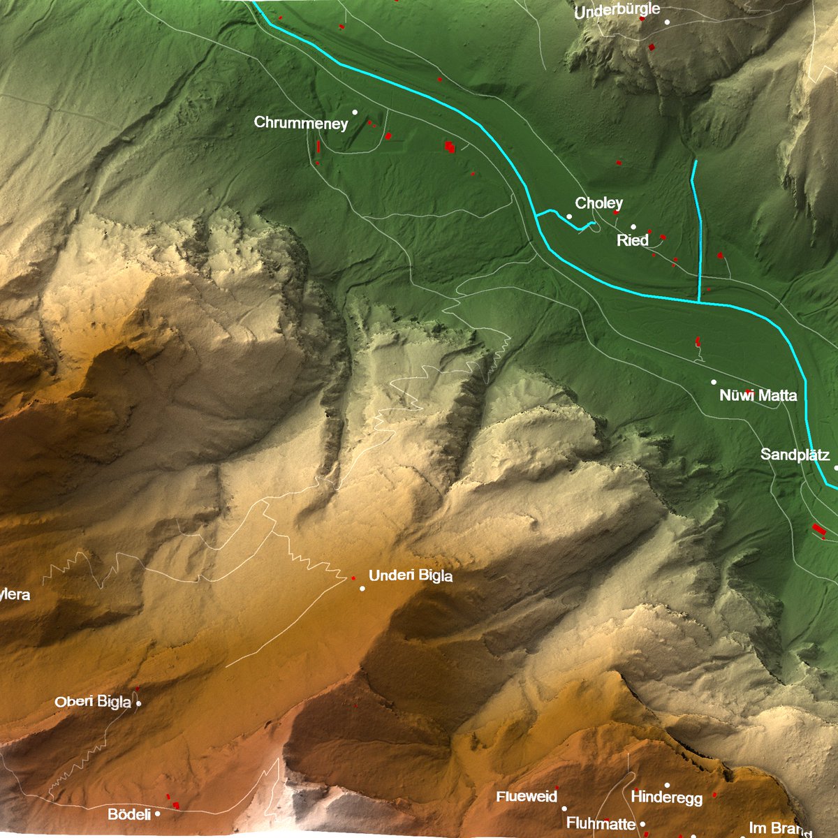
🌎 Struggling with blurry 3D maps from LiDAR data? I've got your back! My new video shows you how to easily access LiDAR terrain data from not one, but 7 reputable sources—and turn them into stunning, crystal-clear 3D visuals like this one 👇 Watch now: youtu.be/N-AtAnXrGm0

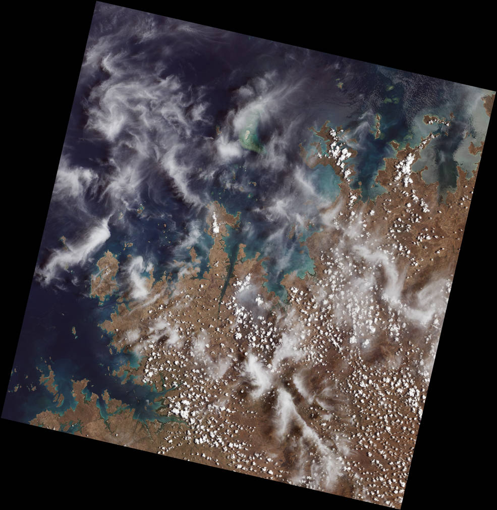
These farms are on the straight, curved, and narrow 🧑🌾 In southern Poland, repeated land divisions over centuries created a complex mosaic of ribbon-like crop fields, captured in this image by @NASA_Landsat 9. Learn more about the farms' history: go.nasa.gov/3DOzKpo


Worked on a #map showing the Darién Gap in #Panama and #Colombia for @WSJGraphics. Large numbers of migrants crossing this area have increasingly overwhelmed the #indigenous communities here. W/ @PerezEnMexico


@NASA Yeah cool news but still pretty dissatisfied with the footage. No cool explosions, no slow mo, just a zoomed in video of a rock. Very disappointing
#Landsat 9 First Light Images 👏🙌😍 svs.gsfc.nasa.gov/13987


Let’s goooooo

Important step for Shapely, and for a faster GeoPandas! See the migration notes for more details: shapely.readthedocs.io/en/latest/migr…
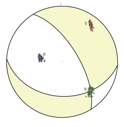
Today's M7.0 Guerrero earthquake (purple star) in the context of the three large events of 2017/2018 in the same region and the Guerrero gap. Original map from nature.com/articles/s4146…

Motion and water dynamics in full display in static imagery. 📍Markermeer, Netherlands (rotated 33°) 📅 May 31, 2021 🛰️ @NASA_Landsat

Cleopatra's Alexandria redd.it/bie7ti #MapPorn

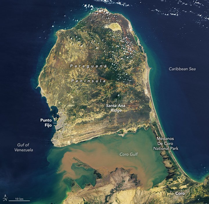
The Paraguaná Peninsula in #Venezuela is rich with sandy beaches and interesting topography. earthobservatory.nasa.gov/images/148162/…

Massive new #QGIS plugin: #GEE Timeseries Explorer offers instant access to #EarthEngine image collections! Fetch #Landsat, #Sentinel2, or #MODIS #timeseries for any location and visualize images: geetimeseriesexplorer.readthedocs.io 🧵
What can we see in Satellite Derived #Bathymetry (SDB)? Here we see sand waves along the Bahama Bank at edge of the "Tongue of the Ocean" where the seafloor drops off from 5m to over 1000m in just a few kilometers. #remotesensing #hydrospatial
Marie Tharp was the right *woman* in the right place at the right time to make the most beautiful, detailed maps of the world's ocean floors. Her story on @ScienceNews by @betsymason bit.ly/2XUurMv #science #Geology #maps #cartography #WomeninScience #platetectonics

Thank you, space lasers 🛰️⚡️


ajfara @ajfara
22 Followers 699 Following

Ana Maria Ortiz @AnaMariaOr41848
948 Followers 5K Following Soy De Mexico🇲🇽....Currently live in England UK. HAPPINESS DOES NOT DEPEND ON WHAT YOU HAVE OR WHO YOU ARE. ITS SOLELY RELIES ON WHAT YOU THINK.....💭💭👌.
Re-tweeter 🇮🇳 @insajay
125 Followers 2K Following It's nun of our abilities that show what we truly are! actually, It's our choices...
BATELEUR EAGLE @EtunyJob
292 Followers 2K Following photogrammetry and remote sensing gis Rugby,football lover. #BESUWIGO.
PoppyJane @YY8IUzL90bWbs
61 Followers 6K Following
Tooshea @Tooshea221301
12 Followers 1K Following The garden is full of spring scenery, with a few red flowers falling all over the ground
Maria Batalha @MariaBatalha123
3K Followers 5K Following Maria Martins Batalha Sexo feminino, nasci em 29 de Julho de 1971 Sou Mineira de Cajuri Zona da Mata.
Hugo @seixasthugo
60 Followers 688 Following PhD student, research on land cover transitions impacts. https://t.co/YlkxVkMtG3
🇧🇿 Belize GEO �... @BzGEO
10K Followers 7K Following Belize GEO: Belize Group on #EarthObservation & GIS. #SciComm re: EO, GIS relevant to #Belize, the #Caribbean. Administered by a real live Belizean scientist.
BetzyEO @EOBetzy
3K Followers 3K Following #EarthObservation scientist supporting #CapacityBuilding / int'l development. Tweets are my own; retweets ≠ endorsements.

Dr. Kate Fickas @katefickas
5K Followers 5K Following @Esri Director of Imagery & Remote Sensing Solutions 🛰️🌍| Space Science Diplomat @StateDept 🚀| @LadiesOfLandsat Founder 💪🏻| @USGS Mendenhall Fellow 🌦️📈
Emma François @emmajfrancois
315 Followers 600 Following everything is copy or bird's nest material | writing in @GolfDigest @WCP | formerly @Washingtonian @USAToday @GtownVoice @CHQDaily | gtown ‘19 au '22
Michael Hendricks @mhendricks34
294 Followers 274 Following
SuperMap @SuperMap__GIS
7K Followers 5K Following GIS platform software and solution provider. Innovate Geospatial Intelligence, Elevate IT Value. #GIS #3DGIS #BigDataGIS #AIGIS #BIMGIS
Andréa P Nicolau @puzzinicolau
3K Followers 3K Following Sr. Geospatial Scientist @SIG_GIS @ServirAmazonia | @UAHuntsville MS Earth Science | @uff_br BS Env. Eng. | Earth Engine @GoogleDevExpert | Views my own | 🇧🇷
Capital One @AskCapitalOne
116K Followers 16K Following We're the official Capital One Customer Service Twitter team and we're here to help! See important info below:
🇧🇿 Belize GEO �... @BzGEO
10K Followers 7K Following Belize GEO: Belize Group on #EarthObservation & GIS. #SciComm re: EO, GIS relevant to #Belize, the #Caribbean. Administered by a real live Belizean scientist.
Kel Markert @KelMarkert
2K Followers 1K Following Cloud Geographer @google #EarthEngine ☁️ 🛰️ 🌏 | PhD in Civil Eng (Hydrology) 🌊 | Views and opinions are my own. he/him
BetzyEO @EOBetzy
3K Followers 3K Following #EarthObservation scientist supporting #CapacityBuilding / int'l development. Tweets are my own; retweets ≠ endorsements.
Army Geospatial @ArmyGeospatial
2K Followers 258 Following Official site of the Army Geospatial Center. Providing #USArmy timely, accurate, and relevant geospatial information and capabilities. (F/RT/L ≠ endorsement)
Dr. Kate Fickas @katefickas
5K Followers 5K Following @Esri Director of Imagery & Remote Sensing Solutions 🛰️🌍| Space Science Diplomat @StateDept 🚀| @LadiesOfLandsat Founder 💪🏻| @USGS Mendenhall Fellow 🌦️📈
Emma François @emmajfrancois
315 Followers 600 Following everything is copy or bird's nest material | writing in @GolfDigest @WCP | formerly @Washingtonian @USAToday @GtownVoice @CHQDaily | gtown ‘19 au '22
Michael Hendricks @mhendricks34
294 Followers 274 Following
TCarta @TCarta_
797 Followers 870 Following Innovation in mapping. Bathymetry, satellite derived coastal, marine, and terrestrial products. Follow us on Facebook, Instagram and LinkedIn!
Benjamin Page @the_pagemaster
182 Followers 365 Following Remote Sensing Scientist @USGS_EROS | #Landsat Science Research and Development
MapPorn @MapPornTweet
80K Followers 2K Following Official Twitter account of /r/MapPorn. Reminder: There are high-resolution images of the maps if you follow the Reddit links.
SuperMap @SuperMap__GIS
7K Followers 5K Following GIS platform software and solution provider. Innovate Geospatial Intelligence, Elevate IT Value. #GIS #3DGIS #BigDataGIS #AIGIS #BIMGIS
Dr. Eric J Fielding, ... @EricFielding
10K Followers 2K Following Geophysicist at lab in Pasadena, California. Statements and opinions posted by me are my own and not my employer. he/him. Also at @[email protected]

PyData @PyData
75K Followers 704 Following A community for developers and users of open source scientific tools with 200K+ people 🧑🔬 🧑💻, by @NumFOCUS. Join our Discord: https://t.co/rmBFaQvdMM
TensorFlow @TensorFlow
385K Followers 117 Following TensorFlow is a fast, flexible, and scalable open-source machine learning library for research and production.

PyTorch @PyTorch
451K Followers 77 Following Tensors and neural networks in Python with strong hardware acceleration. PyTorch is an open source project at the Linux Foundation. #PyTorchFoundation
NumPy @numpy_team
37K Followers 11 Following Official account of NumPy. Announcements only. For questions and comments, please use the mailing list [email protected].
Geospatial Data Scien... @SpatialML
1K Followers 37 Following Spatial Data Science Publication @shakasom
Matplotlib @matplotlib
44K Followers 115 Following Python library for creating static, animated, & interactive visualizations. Chat w/ us @ https://t.co/QDNR5Khj9w Sponsored by @NumFocus

QGIS @qgis
64K Followers 63 Following Official account of QGIS - the user friendly Open Source Geographic Information System

OSGeo https://fosstod... @OSGeo
30K Followers 186 Following The Open Source Geospatial Foundation... search for our local chapters around the world as well. See you at https://t.co/mCjhOCQaoy
GeoHipster @geohipster
8K Followers 916 Following Mapping the world, one organic vertex at a time. Get your 2023 calendar now at https://t.co/BtCL7MLCnP
Bojan Šavrič @ProjectionWizz
1K Followers 410 Following PhD, geodetic engineer; map projections, cartographic tools; Opinions are my own.; It is good to live on the ellipsoid, because on the sphere would be too easy!
Joanna Merson @JoannaMerson
1K Followers 698 Following Cartographic developer, University of Oregon. Arizona State University and University of Victoria Alum. I map, I teach, I aspire.
Tom Patterson @MtnMapper
12K Followers 16 Following Retired public servant (US National Park Service). Love making maps!
National Snow and Ice... @NSIDC
18K Followers 588 Following Advancing knowledge of Earth's frozen regions.
Hexagon Safety, Infra... @HexagonSIG
10K Followers 609 Following Improving resilience and sustainability for the world’s critical services and infrastructure | Part of @HexagonAB
Open Geospatial: OGC @opengeospatial
27K Followers 230 Following OGC’s member-community of experts makes location data Findable, Accessible Interoperable, and Reusable (FAIR) through #innovation #collaboration and #standards
Geospatial World @geospatialworld
33K Followers 3K Following Your trusted knowledge source for all things geospatial. We delve into tech convergence and pivot to Industry 4.0 via Digital Transformation and Sustainability
NGA @NGA_GEOINT
102K Followers 210 Following This is the official account for the National Geospatial-Intelligence Agency.

Joshua Stevens @jscarto
15K Followers 930 Following Cartographic Editor @mapsdotcom. Prev: DataViz Lead @NASAEarth, @NSF PhD Fellow in Big Data Social Sci @PSUGeography. Dad stuff everywhere else. Views my own.
Andréa P Nicolau @puzzinicolau
3K Followers 3K Following Sr. Geospatial Scientist @SIG_GIS @ServirAmazonia | @UAHuntsville MS Earth Science | @uff_br BS Env. Eng. | Earth Engine @GoogleDevExpert | Views my own | 🇧🇷
Harvest @HarvestProgram
7K Followers 2K Following @NASA's Global Food Supply & Agriculture Consortium est. 2017 Earth Data for Informed Ag Decisions (Tweets our own, for official NASA comms visit @NASAEarth)
NASA @NASA
87.8M Followers 154 Following Official NASA account. Exploring the universe, advancing science, and inspiring the next generation of explorers. Verification: https://t.co/8nok3NP4PW
EarthDaily (formerly ... @DescartesLabs
9K Followers 655 Following Descartes Labs was acquired by EarthDaily, a global leader in Earth Observation providing actionable insights and data. Follow @EarthDaily Analytics for updates
Maxar Technologies @Maxar
134K Followers 840 Following Maxar is a leading provider of secure, precise geospatial insights. Our products and services empower users to achieve mission success on Earth and in space.
PrimeWater @PrimeWater_EU
442 Followers 459 Following This project receives funding from the @EU_H2020 Research & Innovation Programme. Any related tweets reflect only the views of the project owner.
ArcGIS Pro @ArcGISPro
29K Followers 89 Following The world's leading GIS software. Start a free trial: https://t.co/o47SA00Ouk ArcGIS Pro Shorts: https://t.co/7KdE6N8NuB Tech Support: https://t.co/kwb2yUrBXP
ARCHIVED - NASA Lands... @NASA_Landsat
78K Followers 437 Following We’ve moved! Visit https://t.co/ObKiWKvAMz or follow @NASAEarth & @NASAGoddard for future Landsat updates.
Scripps Institution o... @Scripps_Ocean
72K Followers 3K Following Understanding and protecting the planet since 1903. @UCSanDiego
NASA Giovanni @NASA_Giovanni
3K Followers 103 Following Information about the NASA Giovanni system will now be available from @NASAEarthdata - go there to see what's new in Giovanni in our 21st year and beyond!Trends for United States
You might like


