
Frontier Precision @frontierprec
With the most experienced staff in the industry, Frontier Precision always delivers unmatched service and support. #frontierprecision #howyoumeasurematters frontierprecision.com 1713 Burlington Drive-Bismarck Joined October 2013-
Tweets1K
-
Followers584
-
Following315
-
Likes232
📍 Why @quantumdrones? ✈️ Aerial intelligence when it matters! Since 2017, they’ve helped us deliver #TrinityPro solutions faster, closer, and with unmatched local expertise. ow.ly/LfXI50WPTF7 #QuantumSystems #HowYouMeasureMatters #FrontierPrecision #UAS #Drones #Unmanned
Join us for a FREE Live Webinar! Thursday, September 11, 2025 | 11 AM – 12 PM (Central Time) Protecting Your Data, Powering Your Work: #Trimble Connect, Windows 10 & Android Cybersecurity Updates REGISTER HERE: ow.ly/6x6450WPPXa #frontierprecision #howyoumeasurematters

Happy Labor Day Weekend from the Frontier Precision Team! Our offices will be closed on Monday, September 1st, so staff can spend time with family and friends! Have a safe and happy holiday! frontierprecision.com #frontierprecision #howyoumeasurematters #laborday

ACSL Inc., announced the launch of its new NDAA-compliant smart controller, TAITEN! The new controller will be available in September through Frontier Precision. To learn more about ACSL Inc. and the TAITEN Smart Controller, read here: ow.ly/q2CE50WMhpC

Join Frontier Precision and Esri for a demo day devoted to public safety! September 23, 2025 | 8:30am - 11:30am (coffee and refreshments 8:30am - 9:00am) Esri Headquarters 880 Blue Gentian Rd #200 Saint Paul, MN 55121 This event is FREE! Register HERE: ow.ly/RzeA50WM9g2

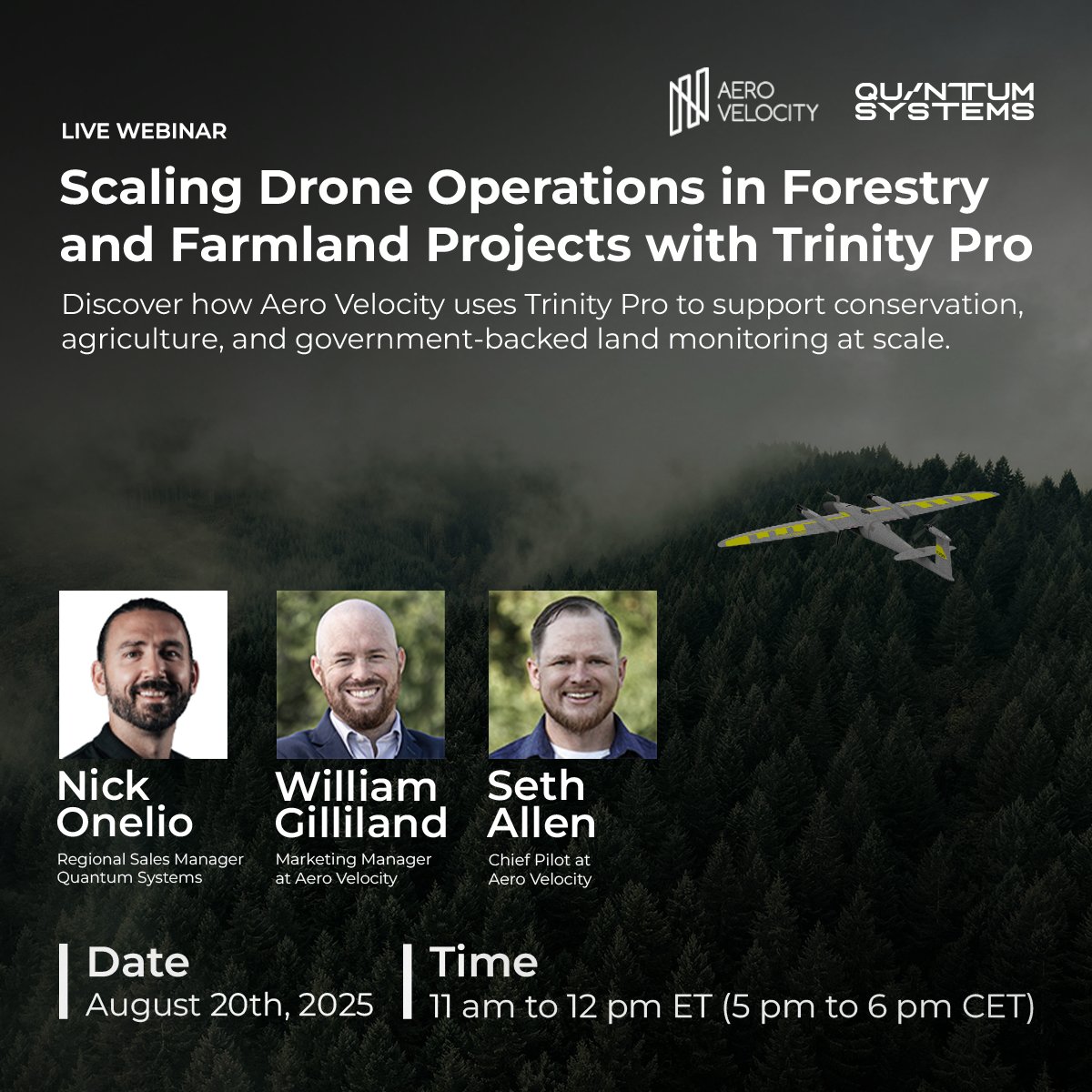
Quantum Systems & Aero Velocity Webinar! Discover how Aero Velocity uses the Trinity Pro to map over 300 acres per flight, collect LiDAR and multispectral data, and scale forestry and farmland monitoring. Register now: ow.ly/cyWw50WGJt4 #frontierprecision #quantumsystems
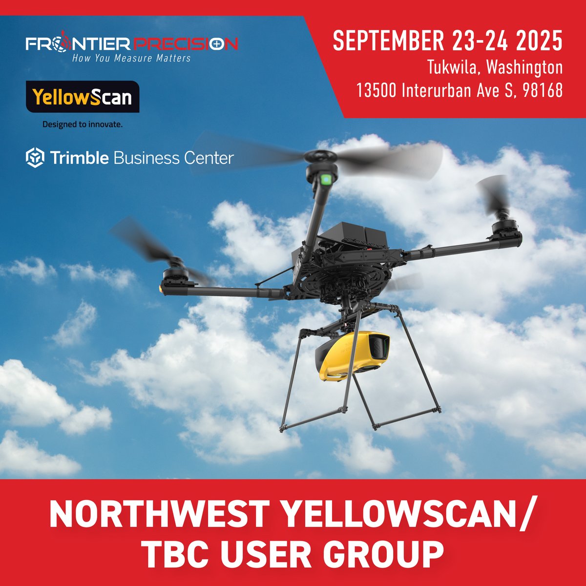
Join us September 23-24 in Tukwila, WA for the Northwest Yellowscan/TBC User Group! 9:00am - 4:00pm Billy Baroo’s Bar & Grill 13500 Interurban Ave S, 98168 ‼️ If you plan on attending, please bring your own personal processing laptop! REGISTER HERE: ow.ly/BO1w50WG3w7
Join us for one of TWO Trimble Workshops in Washington! Topics will include: Trimble Access, Trimble Connected Workflows, Q&A, and more! Register Here: Spokane, WA | 09/30/25 : ow.ly/qX8g50WCb3Q Seattle, WA | 10/02/25: ow.ly/6iaa50WCb3R #frontierprecision #trimble

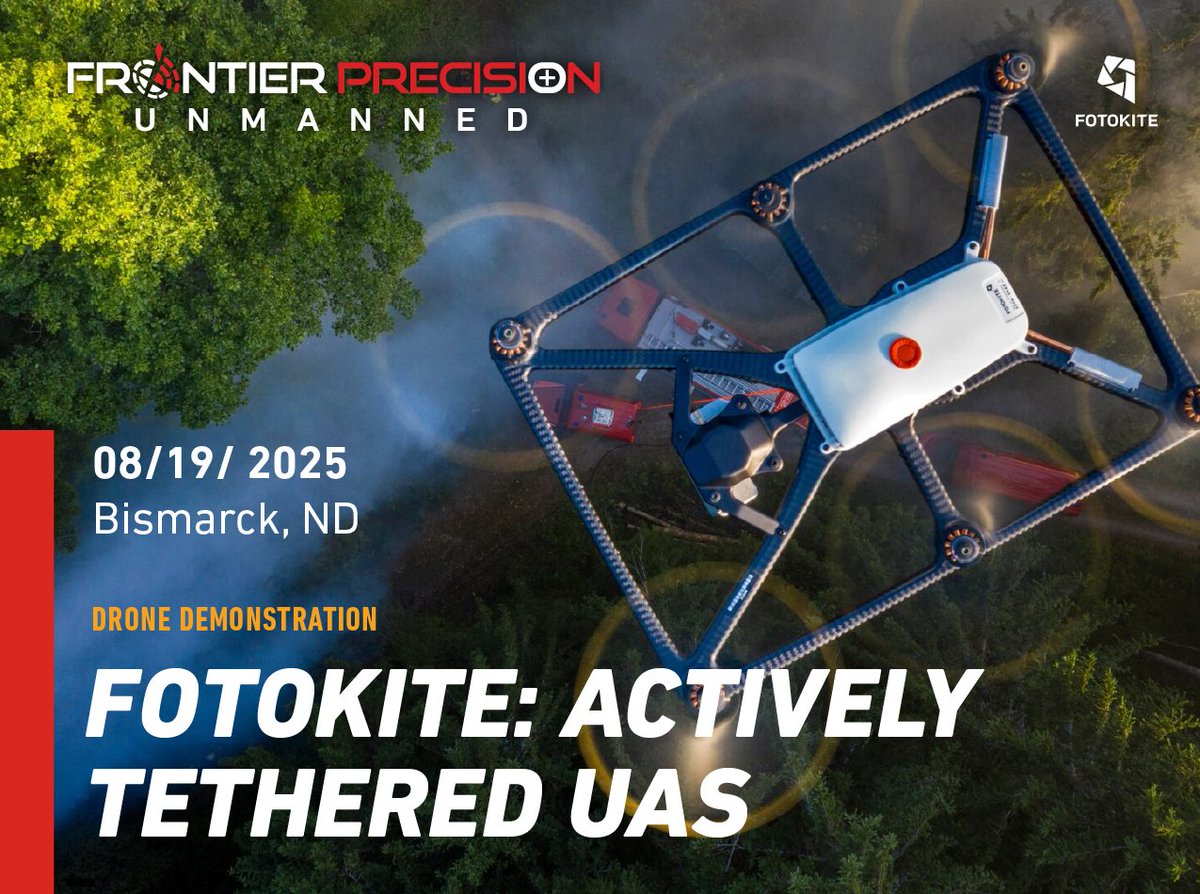
Join us for a live-demo event highlighting the capabilities of the Fotokite tethered aerial system! August 19, 2025 | 9 am -12 pm Frontier Precision | Bismarck, ND 1713 Burlington Drive Register Here: ow.ly/xiWW50WzIKc #frontierprecison #howyoumeasurematters #unmanned
Join us for a FREE Drone Mapping Training in Florida! ‼️ Restricted to Active Law Enforcement/Government Employees Only. August 21, 2025 | 8:00am - 4:30pm 📍Florida Public Safety Institute 75 College Dr, Havana, FL, 32333 REGISTER HERE: ow.ly/jwsJ50WA1Nu

Frontier Precision Unmanned is excited to exhibit at Commercial UAV Expo! Sept. 2-4, 2025 | Las Vegas, USA Learn More Here: ow.ly/fF9K50WrvCY Use code UAVA2530257 for $100 off a Full Conference Passes OR a FREE Exhibit Hall Pass. #expouav #frontierprecision #unmanned

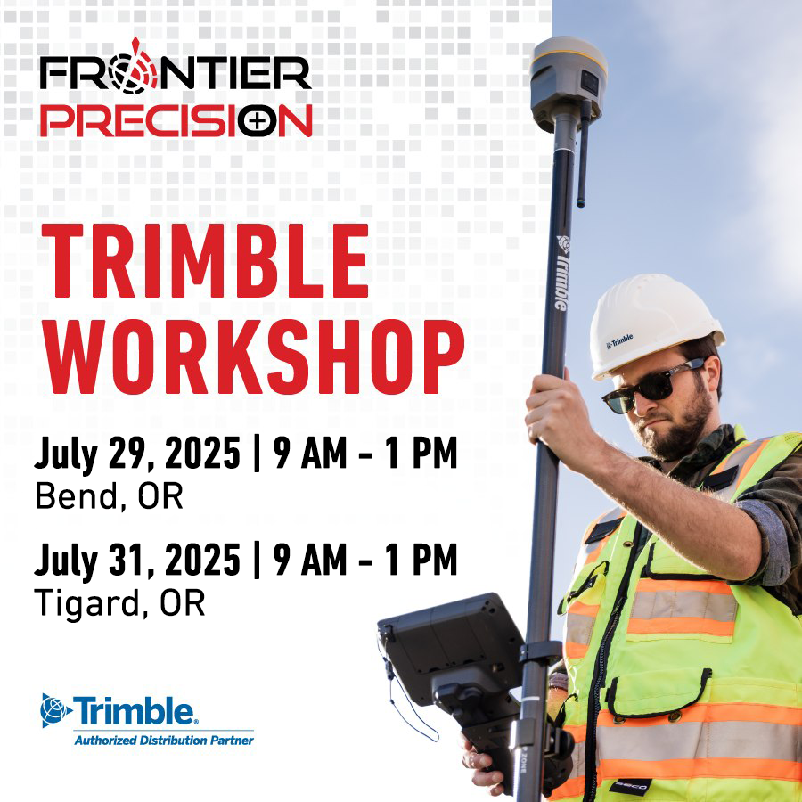
Join us for a Trimble Workshop - July 29, 2025 & July 31, 2025 at TWO Oregon Locations! Topics will include: survey styles and templates, measure and stakeout methods, Q&A, & more! Bend, OR: ow.ly/JKWg50WlQ4M Tigard, OR: ow.ly/5fRW50WlQ4L #frontierprecision #trimble
🇺🇸 Happy 4th of July from the team at Frontier Precision!🇺🇸 All branches will be closed Friday, July 4th , so staff can enjoy a long weekend with family and friends. Have a safe and fun 4th of July! #frontierprecision #howyoumeasurematters #4thofjuly #USA #independenceday

Join us for a FREE Drone Mapping Training in Florida! July 29 | 8:00am - 4:30pm 📍 Plantation Police Department 451 NW 70th Terrace, Plantation, FL 33317 REGISTER HERE: ow.ly/1j9F50Wggyz

Frontier Precision will be at the 2025 Esri User Conference — Come see us! July 14-18 | San Diego, CA San Diego Convention Center | 111 West Harbor Dr REGISTER HERE: ow.ly/nZ4Q50VH7PZ #frontierprecision #ESRIuserconference #geospatial

Join Frontier Precision Geospatial, plus a stellar panel, for this great workshop on learning about Colorado’s new utility relocation law. Register Here: ow.ly/CMvn50W8HrN #frontierprecision #trimble

Frontier Precision is proud to announce a strategic partnership with Tabula, a global leader in GPS-guided proof of application and job management systems. Read the blog to learn more about Tabula and this partnership: frontierprecision.com/news/frontier-… #FrontierPrecision


Frontier Precision is pleased to announce the acquisition of Tenacity Ag. Tenacity has been a leading supplier of spray drone technology to professionals across the upper Midwest for several years. Read More: ow.ly/hVRk50W7VXt #frontierprecision #tenacityag #acquisition

Since 2017, we've been proud to offer Quantum Systems technology. Now, we're taking things to the next level as their Premier Access & Support Partner. Offering on-hand inventory, faster fulfillment & repairs. #quantumsystems #frontierprecisionunmanned

Join us June 16-18 in Houston, Texas! Frontier Precision will be exhibiting at The Energy Drone & Robotics Summit! Booth #406. For more information, or to register: ow.ly/OVMF50W2yUs #frontierprecision #howyoumeasurematters #frontierprecisionunmanned #EDRSummit


Esri @Esri
190K Followers 66K Following Esri builds #ArcGIS, the leading location intelligence and spatial analytics software for mapping, 3D GIS, imagery, and geospatial app development.
josephkerski @josephkerski
14K Followers 2K Following Geography, geo-geekiness, STEM, ed tech, space, place, geographic information systems (GIS), GPS, outdoor education 365 days a year.
LAND SURVEYORS UNITED... @LandSurveyorsU
10K Followers 578 Following ʟᴀɴᴅsᴜʀᴠᴇʏᴏʀsᴜɴɪᴛᴇᴅ.ᴄᴏᴍ #ʟᴀɴᴅsᴜʀᴠᴇʏᴏʀs ᴛᴀᴘ ɪɴᴛᴏ ᴛʜᴇ #sᴜʀᴠᴇʏɪɴɢ ᴇxᴘᴇʀɪᴇɴᴄᴇ ᴏғ ᴏᴠᴇʀ 21ᴋ #sᴜʀᴠᴇʏᴏʀs ɪɴsɪᴅᴇ ʟᴀɴᴅ sᴜʀᴠᴇʏᴏʀs ᴜɴɪᴛᴇᴅ ᴄᴏᴍᴍᴜɴɪᴛʏ. ᴊᴏʙs, sᴜᴘᴘᴏʀᴛ & ᴍᴏʀᴇ ✊
NEI @NEIGPS
420 Followers 347 Following NEI is your one-stop-shop for survey, MGIS, marine, public safety, and construction sales, service, support, training, fleet management and equipment rentals.
Laser Tech @LaserTechInc_
903 Followers 626 Following Our mission is to equip professionals with smart measurement solutions that help create a safer world.
Connecting Skies @ConnectingSkies
18 Followers 392 Following
Nema @NekoizFra
1 Followers 33 Following
Ivan @Ivan46389964
1 Followers 67 Following
Pete Kelsey @MrPeteKelsey
104 Followers 67 Following Technologist, Storyteller, and a work in progress
Nora @quantahX
80 Followers 389 Following
Gleipnir @GleipnirSocial
0 Followers 1 Following Small business that creates easy to use efficient technology to make your business better.
Dylantro @jone1923
11 Followers 75 Following

Kamizelo Pistis @kamizelo_pistis
42 Followers 573 Following Business Strategy and Management Manager/Manager Adjoint OPS CarpeDiem protectionLLC RDC/Officier des protections de droits de L'homme ONG ASFDH.
PLSS Map @plssmap
3 Followers 45 Following I'm an app for finding section/range/township locations. The section/range/township system is formally known as the Public Land Survey System (PLSS).

Ishan Roy @1shan4Tense
8 Followers 315 Following
Linventix @linventix
2 Followers 48 Following
Lonny @Lonny1875
6 Followers 88 Following
@Intuitions @Intuitionsinf
18 Followers 1K Following Interested in all forms of learninggg, intelliiigence and ofcourse realityyyy.
ମାଟିର ମ�... @RadheShyam2026
137 Followers 4K Following अनुगच्छतु प्रवाह l ଓଡ଼ିଶା- ମାତୃ ଭୂମି, ଓଡ଼ିଆ- ମାତୃ ଭାଷା । ଶ୍ରୀ ରାଧା। ସର୍ବ ସମର୍ପଣ। ଜୟ ଜଗନ୍ନାଥ।
MaxPayne @max_payne1986
2K Followers 6K Following Before Patriot, Now Nationalist.🇮🇳 ഭാരത് മാതാ കീ ജയ്.....


Chill🛡️ 🧘�... @Astroneeit
207 Followers 2K Following Art & Charts ❤️ Concept art & Breakouts ⚡️ Astronomy, science , Tech , sci-fi, sketchbook.
Sandeep Maurya🇮�... @Sandeep_mauryaG
321 Followers 1K Following राष्ट्रहित सर्वोपरि 🇮🇳 ||देशभक्त || निंदक || अतिक्रोधी || चुनौतियों से मुकाबला करने में सक्षम || यदमुल्ले = सपोले || शत्रुबोध परम ज्ञानं || 💯% फॉलोबैक
Gautam Singh @GautamS67987143
18 Followers 956 Following
shivansh puri @shivanshpu29280
177 Followers 3K Following

Meteoricwater @meteoricwater
1 Followers 326 Following
Sthithapragna 🇮�... @Sthitapragna14
131 Followers 2K Following
The Utility Expo @TheUtilityExpo
6K Followers 2K Following The largest and fastest growing trade show in the utility industry | October 7-9, 2025 | Louisville, Kentucky, USA
Kelley Messer @messer_kelley
62 Followers 327 Following

Liu文 @Liu909123456
1 Followers 345 Following
Robert Winkler @Robert070766
3 Followers 63 Following
AmericaView @AmericaView
508 Followers 207 Following A Nationwide Consortium for Remote Sensing Education, Research, and Geospatial Applications. - Empowering Earth Observation Education
Born Aviator @BornAviator1
25 Followers 3K Following
Jeff Zenner @jeffzenner
720 Followers 2K Following Jeff Zenner Photography - FAA Certified Remote Pilot/Drone Operator & Photographer - Agriculture, Aerial & Outdoor Scenic Photography from the Pacific Northwest


Akut bölük @14Akut
34 Followers 20 Following Mastering market patterns for better trading. Technical analyst and trader sharing the journey
standingutilitybag @standingtuility
0 Followers 6 Following
RTKdata @RTKdata
45 Followers 421 Following Empowering precision with the world's leading RTK network. 19,000+ base stations in 140+ countries. Let's innovate together! 🌍 🚀#RTKdata
World Lidar Day @lidarday
17 Followers 69 Following
Presler Jean @PreslerJean
39 Followers 179 Following GIS Analysis, Database Management, Data Visualization, UAV Operations, Drone Piloting, Drone Mapping/Photography, Geospatial Modeling and Remote sensing
Sarhan Salim @SarhanSalim9
1 Followers 38 Following

Hon Dunom @dumoro
1K Followers 5K Following Brash and searing. Viciously fight for democracy and cleansing the Kenyan politics. Enthusiast of discovery and development services.
Mukama Jamali @jamali_mukama
6 Followers 311 Following
BloojayMedia @BloojayM
2 Followers 63 Following We are a down to earth, goal driven and yet have a certain whimsical nature. After all, ideas are conceived in the land of creativity, to tell your story.
PixElement @PixElementTech
31 Followers 311 Following PixElement's patented algorithms convert aerial images from drones, planes, or satellites into precise 3D models.
Skydio @SkydioHQ
22K Followers 487 Following Skydio is the leading U.S. drone manufacturer and world leader in autonomous flight.
Tom Searing @FalconA26r
4 Followers 61 Following Remote Sensing SME, Drone Pilot, Aviation Enthusiast
Trimble Geospatial @TrimbleNews
10K Followers 174 Following Leading provider of advanced positioning solutions for survey and geospatial professionals that maximize productivity and enhance profitability.
Esri @Esri
190K Followers 66K Following Esri builds #ArcGIS, the leading location intelligence and spatial analytics software for mapping, 3D GIS, imagery, and geospatial app development.
josephkerski @josephkerski
14K Followers 2K Following Geography, geo-geekiness, STEM, ed tech, space, place, geographic information systems (GIS), GPS, outdoor education 365 days a year.
NEI @NEIGPS
420 Followers 347 Following NEI is your one-stop-shop for survey, MGIS, marine, public safety, and construction sales, service, support, training, fleet management and equipment rentals.
Esri GIS Education @GISEd
21K Followers 685 Following Esri GIS Education - news, curriculum, software, tools and more
Trimble Inc. @TrimbleCorpNews
12K Followers 59 Following Trimble is a global technology company that connects the physical and digital worlds, transforming the ways work gets done.
Laser Tech @LaserTechInc_
903 Followers 626 Following Our mission is to equip professionals with smart measurement solutions that help create a safer world.
Geospatial Stuff @GeospatialStuff
5K Followers 5K Following We tweet everything Geospatial related including GIS, geomatics, drones, open data, location technology, maps & much more
UMGEOCON @umgeocon
58 Followers 90 Following Upper Midwest Geospatial Conference THE geospatial community opportunity to connect across borders to the benefit of the nation! May 23-24, 2018. La Crosse, WI
Get Kids into Survey @GetKidsintoSurv
2K Followers 1K Following #GetKidsintoSurvey building awareness of the #geospatial Ind globally by delivering fun interactive content for the young generation #geography #surveyor #STEMEverything is Somewhe... @surveying
8K Followers 185 Following Keeping the geomatics community informed via The American Surveyor Magazine, Everything is Somewhere podcast and more...
KOREC Group @KORECGroup
3K Followers 2K Following KOREC provides measurement solutions, surveying equipment & mapping systems for the geospatial, engineering & construction sectors in the UK and IRE.
UAS Colorado @UASColorado
844 Followers 1K Following UAS Colorado is a non-profit business league promoting the unmanned aircraft systems (UAS) community in Colorado for the benefit of the public.
INTERGEO @InsideIntergeo
4K Followers 530 Following 24 - 26 September 2024 | STUTTGART | The World's No.1 Event for the Geospatial Community | Digital Twins, Digital Mapping, BIM, Smart City, UAV

Spike by ikeGPS @Spike_ikeGPS
319 Followers 176 Following The Spike device, Spike mobile app, Spike Cloud and your smartphone or tablet work together to change the way measurements are taken and shared.
The Boeing Company @Boeing
691K Followers 255 Following Boeing is dedicated to advancing aerospace technology by investing in our people’s careers and encouraging innovation at every turn.
Malheur National Fore... @MalheurNF
4K Followers 306 Following The forest includes high desert grasslands, sage and juniper, pine, fir and other tree species. Hidden gems of alpine lakes and meadows.
Umatilla NF @UmatillaNF
3K Followers 181 Following Official Twitter site for the Umatilla National Forest.
Monde Geospatial @MondeGeospatial
11K Followers 3K Following Geospatial videos, news, articles and events relating to #GIS, #cartography, #RemoteSensing, #GPS, #Surveying, #Geomatics and #geospatial technologies

Mt. Hood National For... @MtHoodNF
19K Followers 374 Following Mt. Hood National Forest's official account. Located 50 miles east of Portland, Mt. Hood is a mecca for recreation, clean water & much more!
NWGIS User Group @nwgis
153 Followers 58 Following Northwest GIS User Group | NWGIS Users Conference held annually at different locations across the Pacific Northwest. https://t.co/F3D0fQUx73
GIS and Science @GISandScience
30K Followers 10K Following Sharing issues and applications of geospatial technology for scientific research and understanding. Tweets by the @Esri Science Team with @deepseadawn
michael GOULD (@mgoul... @0mgould
11K Followers 3K Following I mostly use bloo sky now. #travel #mountainbike #internationalDev #GIS #Spain #sarcasm
Gretchen Peterson @PetersonGIS
14K Followers 826 Following For the love of cartography. Some of my tweets are ephemeral.City of Duluth, MN @cityofduluth
11K Followers 189 Following Official Twitter Page of City Of Duluth, MN.
City of Twin Falls @CityofTwinFalls
2K Followers 35 Following Our mission is to meet the needs of the community, promote citizen involvement, preserve our heritage, protect our resources and enhance quality of life.
CityofMapleGrove, MN @maplegrovemngov
4K Followers 328 Following Official Twitter feed for the City of Maple Grove, Minnesota
City of Minneapolis @CityMinneapolis
213K Followers 224 Following Official news and information from the City of Minneapolis. For non-emergency requests, call 311.
Sawtooth NF @SawtoothNatlFS
2K Followers 147 Following The forest covers 2.1 million acres in South Central, Idaho, with HQ in Jerome. This is an official USDA FS site. https://t.co/CRnKOjuua2…
USFS Northern Region @FS_Region1
7K Followers 339 Following Escape the crowds | Experience solitude | Outdoor opportunities for all | Montana, Idaho, and Dakotas | Privacy: https://t.co/Bize9sqVgQ
Northern Research @usfs_nrs
14K Followers 1K Following The US Forest Service's Northern Research Station develops & communicates science in 20 Northeast and Midwest states for managing healthy, productive forests.
Weyerhaeuser @Weyerhaeuser
5K Followers 776 Following Working together to be the world’s premier timber, land, and forest products company.
WM @WasteManagement
48K Followers 1K Following WM is the leading provider of comprehensive environmental solutions in North America. Twitter Hours: 8-5 CST (Mon-Fri)
Puget Sound Energy @PSETalk
57K Followers 1K Following We’re leading the charge to build a cleaner, smarter, and stronger energy system for our customers. Power out? Report & track at https://t.co/D3Dt2ahPE0
OregonDOT @OregonDOT
87K Followers 481 Following Official Oregon Dept. of Transportation Twitter account. Monitored during business hours only. Road & weather conditions 24/7, use https://t.co/XkNw1P2spa.
WADOT @405daily
1K Followers 0 Following
what3words @what3words
43K Followers 4K Following what3words is the simplest way to talk about location. It has divided the world into 3m x 3m squares, each with a unique 3 word address. Free app on link below.
AMCA Young Pros 🦟 @AMCAYPs
1K Followers 413 Following A group of young professionals (5 yrs or less in field) dedicated to research & practice of mosquito control & public health. 🦟
Helena-Lewis&ClarkNF @LewisandClarkNF
4K Followers 277 Following The official Twitter account for the Helena-Lewis and Clark National Forest located in Central Montana. 🌈
Nez Perce-Clearwater ... @NPClwNFs
3K Followers 54 Following The official Twitter account for the Nez Perce-Clearwater National Forests. Disclaimers: https://t.co/JonHgDx2hJ Comment policy: https://t.co/2xBuLbBLAl
Idaho Panhandle NFs @ID_PanhandleNFs
4K Followers 136 Following The official Twitter account for the Idaho Panhandle National Forests (Coeur d'Alene, Kaniksu and St. Joe).
Salmon-Challis NF @salmonchallisnf
4K Followers 183 Following The Salmon-Challis National Forest covers over 4.3 million acres in east-central Idaho.FireScience.gov @FireScienceGOV
11K Followers 742 Following Your source for wildland fire science resources. Get weekly fire science news updates here! http://t.co/sFYG8pdwUC
Forest Service_NIFC @FSNIFC
9K Followers 284 Following The National Interagency Fire Center is the nation's support center for wildland fire. The USDA Forest Service is one of nine agencies that comprise NIFC.
NPS Fire & Aviation @FireAviationNPS
15K Followers 688 Following Official account for National Park Service Fire and Aviation. NPS Aviation, Structural and Wildland Fire are dedicated to leadership, safety, and collaboration.
Bureau of Land Manage... @BLMFire
27K Followers 2K Following BLM Fire prioritizes firefighter & public safety while protecting natural landscapes, wildlife habitat, & recreation areas.
Boise Nat. Forest @BoiseNF
4K Followers 400 Following The Boise NF is north and east of Boise,Idaho totaling 2,612,000 acres. This is an official USFS site. FS Disclaimers: http://t.co/TpDTVBQr
The Wilderness Societ... @Wilderness
90K Followers 5K Following Uniting people to protect America’s wild places.
National Forest Fdn. @NationalForests
32K Followers 2K Following We work with the U.S. Forest Service and thousands of Americans to promote the health and public enjoyment of our 193-million-acre National Forest System.
Forest Service, Pacif... @yourpswforests
17K Followers 725 Following Regional news. We manage public lands & assist State/Private forest landowners in CA, HI & the U.S. Affiliated Pacific Islands. Sharing doesn't = endorsement.
Forest Service NW @ForestServiceNW
98K Followers 1K Following Pacific Northwest Region of the Forest Service has some of the most breathtakingly beautiful areas on Earth ranging from grasslands to lush forests & beaches.
TerraGo @TerraGo
3K Followers 1K Following Whether it’s used on the front lines or utility lines, TerraGo software has always put power in the hands of personnel in the field and on the move.
Drones and IoT @Drones_IoT
926 Followers 25 Following Focused on #Drones #UAV #UAS for #Military and Commercial markets including #IoT integration and #IndustrialAutomation
Geospatial Profession... @URISA
10K Followers 3K Following The Geospatial Professional Network (formerly URISA) is a community of emerging and experienced GIS professionals.
Ricoh USA @RicohTweets
14K Followers 3K Following We bring people, processes, and technology together to make information work for you.Trends for United States
You might like