Search results for #Mapping

Asst. Prof. @DimitrisTsiachr verifies that RHYTHMIA combined with INTELLANAV ST enables the identification of clear and precise His signals, contributing to safer AVNRT procedures and reduced X-ray exposure. Explore further details about this approach here! #mapping #EP #EPeeps
We refer to them often while we #travel or have used them in schools and in our daily lives for information, but what exactly is a #Map? Click below to find out. mapsofindia.com/what-is-map.ht… #Maps #Mapping #Geography #education #knowledge #MapsOfIndia
day 26 of the challenge: there's no time! #womenartists #drawing #mapping


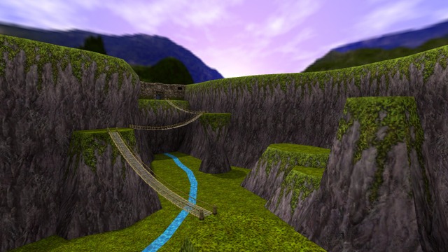
The canyon of the water-worshipping civilization! The map continues, opening up into this canyon. The bridges are all brushes. By Lily McFluffy Butt in Garry's Mod / Mapping community.lambdageneration.com/gmod/post/kbgn… #gmod #mapping

#jobingis: FAO is hiring a Commune Risk Map Specialist 📍: #Homebased Apply here 👉 : jobingis.com/jobs/commune-r… #Jobs #mapping #GIS #geospatial #remotesensing #GISjobs #Geography #cartography #remotejob

#jobingis : Farmers for Forests is hiring a GIS/Data Analyst 📍 : #Beed, #Pune , #Solapur, #India Apply here 👉 : jobingis.com/jobs/gisdata-a… #Jobs #mapping #GIS #geospatial #remotesensing #GISjobs #Geography #cartography #remotejob

The Geological Survey of India (G. S. I.) first published the #seismic zoning map of the country in the year 1935. Here is a map showing the seismic #zones in #India. mapsofindia.com/maps/india/sei… #Earthquakes #Earthquake #Geography #Map #Mapping #MapsOfIndia

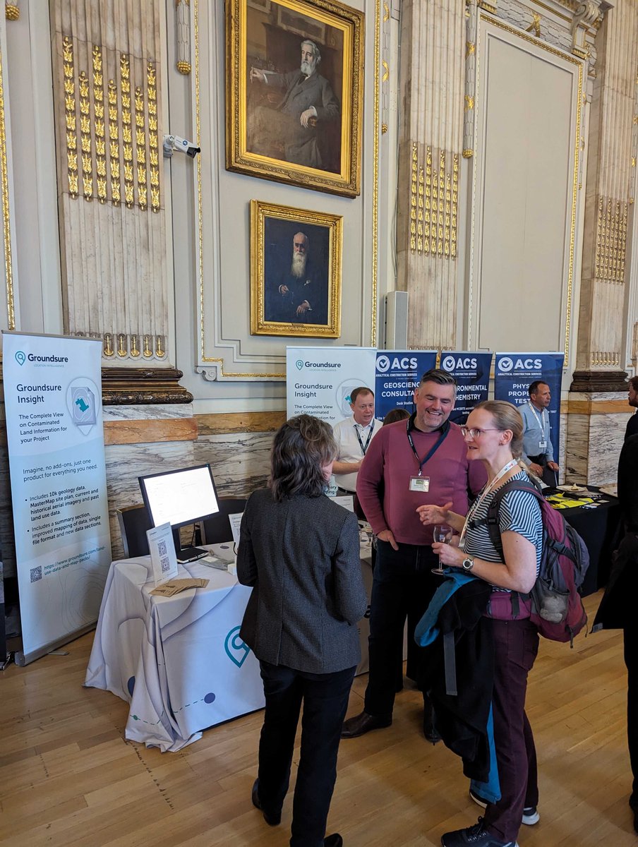
Thank you all for visiting our stand yesterday at the @agsgeotech Annual Conference. It was lovely to meet new faces as well as catch up with existing customers. We hope you all had a great day! #geotechnical #geoenvironmental #engineering #data #mapping #experts #conference

Happy National Day, Netherlands! 🇳🇱 Explore this breathtaking #Sentinel2 image of Amsterdam, from our PlanetSAT Global 10m #SatelliteImagery #Basemap! 🌎 Did you know that Amsterdam is currently home to more bicycles than actual residents? 🚲 #GeospatialData #Geospatial #Mapping


Our new video tutorial is here to help you learn how to create PNG maps with freehold boundaries using #AutoCAD, enabling precise property delineation and efficient land management. #Planners #Architecture #FreeholdBoundaries #Mapping

🚀 Meet RFLY - CRUZE: Elevating project management with advanced aerial surveying & mapping! 🌐✈️ Revolutionize your projects now! #drone #aerialsurveying #mapping #aerialservices #innovation #RFLY #Cruzedrone


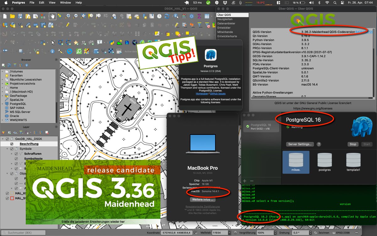
QGIS-Tipp: Downloads für 3.36.2 “Maidenhead” (RC) & 3.34.6 “Prizren” (LTR) verfügbar! Test@MacM1 geoobserver.de/2024/04/qgis-t… #qgis #switch2qgis #gistribe #gischat #fossgis #foss4g #OSGeo #spatial #geospatial #opensource #mapping #gis #geo #geoObserver pls RT @JuergenEFischer

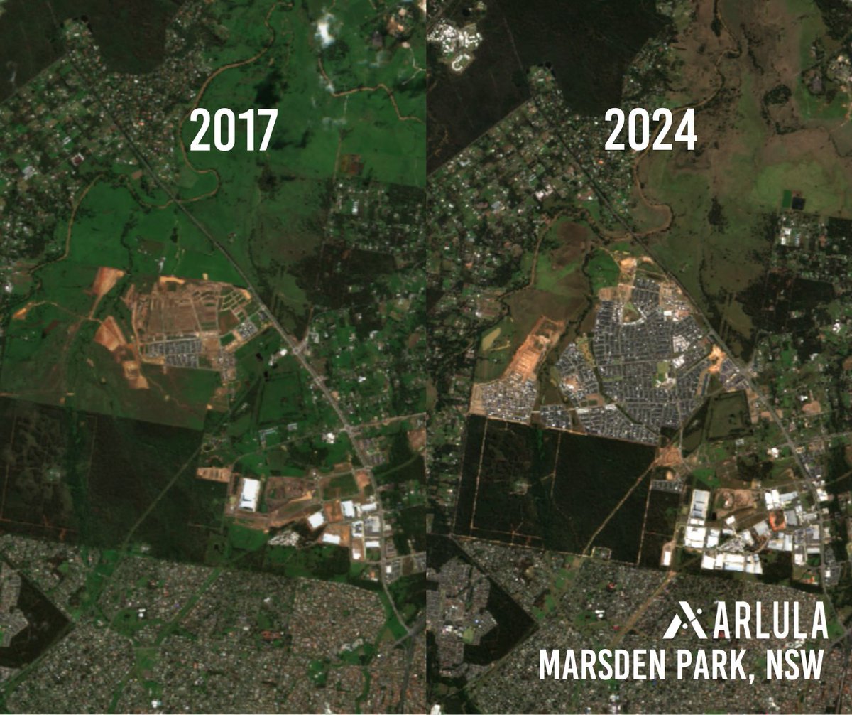
#MarsdenPark on the rise! 📈 Marsden Park is one of NSW's fastest-growing areas. Here we've captured its rapid #urban growth from 2017 to 2024 with satellite imagery. Follow us for more #satelliteimagery insight! 🛰️Sentinel L2 2017 to 2024 📌Marsden Park, NSW #mapping #city

#Horticulturae - Highly Cited Paper🍀 📖Title: #Mapping of the Susceptibility of Colombian #Musaceae Lands to a Deadly #Disease: #Fusarium oxysporum f. sp. cubense Tropical Race 4 ✍️By Gustavo Rodríguez-Yzquierdo et al. 🔗Link: mdpi.com/2311-7524/9/7/… @LifesciMdpi


U, uw stakeholders, collega's en leden van de gemeenschap hebben ook geweldige ideeën. Een nieuwe functie in ArcGIS Hub kan u helpen die ideeën om te zetten in inzichten en actie. Discussieborden zijn er klaar voor! #GIS #Geospatial #Mapping ➡️ esri.com/arcgis-blog/pr…
From GIS Lounge: Tracking Penguin Colonies Through Their Droppings bit.ly/44g8vN3 #GeographicInformationSystems #LocationIntelligence #GeospatialData #Mapping #GISAnalysis #SpatialData #GISMapping #GeospatialTechnology #GISConsulting #GISSoftware #GISServices #G...


Mapping excellence with AAEIMAA GIS delivers top tier geographic information system services, specializing in digital image processing utility mapping and location based solution. #GISAnalytics #GIS #datavisualization #techinnovation #maps #mapping #aaeimaaengineering


En los proyectos de #RentalAgencyEvents & #InstallSales la calidad que entregamos y el desarrollo es la función entre el #diseño y la #ingeniería. Somos V-TECH Visual Technology #gobierno #ventas #eventos #humanidad #proyeccion #3d #mapping #contenido instagram.com/reel/C6NI8I4Ji…
Mapping London @MapLondon
5K Followers 4 Following Highlighting the best of maps of London. Mapping people, places, data, things.
Business Mapping @mapping
53 Followers 0 Following Business Enterprise Mapping - Business Enterprise Mapping consulting solutions.
Nichole @MappingMomLife
27K Followers 11K Following Raising my kids in #Florida with plans to move to #Tennessee and mapping the mom life as we go! Partner Collabs: [email protected]
Beer Mapping Project @beermapping
12K Followers 2K Following Twitter updates from The Beer Mapping Project
Florida Data Geek ✝.. @MappingFL
8K Followers 396 Following Florida Data and Redistricting Guy (He/Him). Lefty Lutheran. Politics, religion, and wrestling. Sign up for my substack! This election is going to kill me
Harita Genel Müdürl.. @harita_turkiye
7K Followers 2 Following Harita Genel Müdürlüğü Resmî Twitter Hesabı Official Twitter Account of General Directorate of Mapping
Mapping Our Thoughts @MapOurThoughts
2K Followers 32 Following Helping learners to excel in C++ & math. Providing top-quality education & tutoring. Lowering the cost of college. #Programming #Cpp #Math #Education
OHBM @OHBM
19K Followers 3K Following Our purpose is to advance the understanding of the anatomical and functional organization of the human brain, and promote its medical and societal applications.
Falklands War Mapping.. @Mapping1982
1K Followers 21 Following Official feed of the Falkland War Mapping Project - a pioneering collaboration between Oxford University, Glasgow University, Waterloo Uncovered and FIM&NT.Surveying & Mapping @surveying
8K Followers 148 Following Keeping the surveying community informed about surveying, mapping, and technology news via The American surveyor Magazine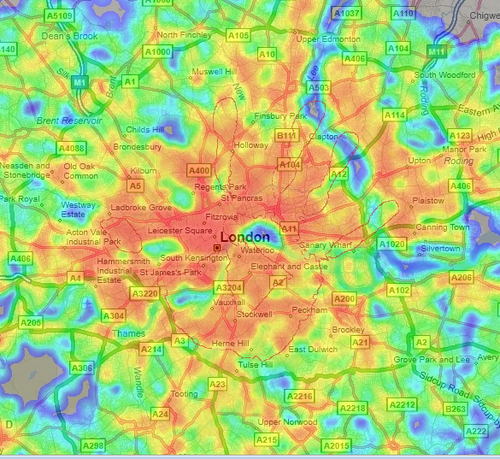
ExcelMapping @ExcelMapping
6K Followers 0 Following Free Excel®™ add-in enables you to visualize your Excel®™ Spreadsheets on a map. Free download http://t.co/IZzapBUxdz
Mapping Caste Atrocit.. @mapatrocities
465 Followers 2 Following Mapping Caste Atrocities is a @LIFEforRights attempt at documenting and recording caste atrocities against Scheduled Castes and Scheduled Tribes communities.
Mapping Ignorance @MapIgnorance
5K Followers 206 Following Spreading the latest developments in #Science. A project by Chair of Scientfic Culture of UPV/EHU (@Zientzia).
Ethiopian Media Autho.. @EthMediaAuth
10K Followers 19 Following Media Regulation, Capacity Building and Policy Making
The American Redistri.. @MappingAmerica
649 Followers 0 Following All things redistricting. All in one place.
mappingBIGdata @mappingBIGdata
6K Followers 0 Following Visualize your Big Data in minutes, look into the future using our Prediction Analytic tools and watch the trends emerge.
Human Brain Mapping @raneuron
442 Followers 12 Following Rafeed Alkawadri’s public account: Join us on a mission to demystify the brain one millisecond at a time. opinions our own.
Waze Mapping Support @WazeMapping
2K Followers 13 Following The Ways of Waze mapping. Info is typically generalized, but oftentimes specific to North America or the US. Not run by Waze, but pretty darn close.
Hunter @HunterMapping
11K Followers 187 Following Internet search engine for security researchers https://t.co/PYY1kXgbii
Mapping Maps Newslett.. @MappingMapsNews
504 Followers 11 Following A monthly newsletter on all things Wardley Maps. Subscribe here - https://t.co/OOsK9IWezG Past newsletters - https://t.co/fqAOQ2yBaU Curated with ❤️ by @harprits
Helium Mapping🎈 @HeliumMapping
8K Followers 1K Following Mapping updates of #ThePeoplesNetwork, run on the @Helium Blockchain. Contribute to the Mappers API with a LoRaWAN GPS: https://t.co/IotyhaPTiO 🗺️.
Open Mapping Hub Asia.. @openmapping_ap
2K Followers 375 Following The Open Mapping Hub - Asia Pacific aims to facilitate collaboration and power the evolution and growth of OSM ecosystems in 25 priority countries across AP.
The Mapping Project #.. @MappingProj48
4K Followers 420 Following The Mapping Project aims to cultivate an understanding of Boston area institutional support for the colonization of Palestine and harms that we see as linked.
Mapping Botswana @MappingBotswana
843 Followers 76 Following We are mapping Botswana on @openstreetmap . Also on Facebook: https://t.co/iNEQEAWE8Y
Crisis Mapping @crisismapping
975 Followers 6 Following Join the International Network of Crisis Mappers (CM*Net)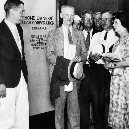
Mapping Inequality @HOLCRedlining
3K Followers 35 Following Mapping 20th century federal home ownership policy. Part of @americanpano. (@3underscores, @lwinling, @ndbconnolly, @marcianorichard, @justinmadron)
Mapping Network @mappingnetworks
1K Followers 80 Following Helping build the decentralized network infrastructure. Canadian Distributor for Helium Hotspot, Miners and LoRaWAN Accessories.
National Atlas & Them.. @natmodst
240 Followers 114 Following Premier mapping organisation with geospatial insight to secure the Nation including visually impaired communities. Follow: https://t.co/MOO1IwqdIS
UN Mapping Report @MappingReport
726 Followers 8 Following #MappingReport: UN Report on the most serious violations of human rights and international humanitarian law committed in DRC between March 1993 and June 2003
ParaPower Mapping @KlonnyPin_Gosch
6K Followers 3K Following A cork board podcast mapping the interlocks & hidden passages of the capitalist elite. Moneyed fams, secret societies, intel networks, & trafficking rings.
Mapping the Mind: Tor.. @mappingthemind
3K Followers 926 Following Official account of Mapping the Mind: Toronto Psychedelic Science Conference. Follow us for conference updates and psychedelic science and drug policy news.
MappingGIS 🚀🌍 @MappingGIS
23K Followers 308 Following Formación que impulsa tu perfil GIS. Cursos online de #QGIS #R #ArcGIS #PostGIS #webmapping #python #GeoServer #OpenLayers #Leaflet #gisenlanube #teledeteccion
Abnormal Mapping @AbnormalMapping
1K Followers 15 Following More media crit than you can shake a stick at! Email us at [email protected]! If you can, support us at https://t.co/6oJykg0cpQ
Brain Mapping Fdn. @BrainMappingFdn
398 Followers 2 Following The Brain Mapping Foundation fosters multidisciplinary Brain and Spinal Cord research, and the integration of cutting-edge technologies in Neuroscience.
Mapping Africa’s En.. @MAEASaMProject
1K Followers 81 Following Mapping Africa’s Endangered Archaeological Sites and Monuments project funded by @ArcadiaFund
Theti Mapping @ThetiMapping
4K Followers 596 Following Mapper (currently covering war in Israel/Gaza; Russia/Ukraine)
ROKUMORI/六森 - R.. @Lazy_Mori
7K Followers 972 Following freelancer 台灣人 @lazy_mori = @Mori_vrc works:https://t.co/KlVI6tgFzc
ThinkReliability @CauseMapping
1K Followers 96 Following Transforming work cultures one mindset at a time. We use #rootcauseanalysis to help solve problems & improve work processes. Case studies posted regularly.
EnfeMapping @EnfeMapping
46 Followers 10 Following
Maturity Mapping @MaturityMapping
824 Followers 197 Following Maturity Mapping, a way of creating context specific maturity models using practice as the central unit of analysis. Built on #WardleyMaps
Abaaraha Crisis Mappi.. @abaaraha
4K Followers 390 Following Digital volunteers trying to connect relief respondents with Somalia's drought victims [email protected]
Community Mapping Lab @cmaplab
336 Followers 21 Following Community Mapping Lab at the University of Georgia. All tweets our own.
National Center for A.. @NCALM_UH
884 Followers 84 Following Airborne geodetic imaging for the research community. #Lidar, science, archaeology. Geosensing Systems Engineering & Sciences grad program at UH.
GISinc, a Continental.. @gisincorporated
2K Followers 474 Following A GIS professional services firm delivering customer-driven location technology solutions to federal, state & local governments, and commercial organizations.
Waypoint Mapping @WaypointMapping
897 Followers 95 Following Waypoint Mapping is an invite-only team of map builders in the game @trackmania, started in 2017. Open for commissions. Join our discord: https://t.co/mFke91nluu
Joseph Elfelt https:/.. @MappingSupport
4K Followers 255 Following My new content is on Mastodon, not here Developer of https://t.co/PUG9Ce2Uon - Your property lines on Google aerial. See https://t.co/x7r8jsQOSH for my other projects.
HeavyM | Projection M.. @HeavyM_Software
1K Followers 247 Following HeavyM 2 OUT NOW! HeavyM 💫 The easiest #projectionmapping software to create impressive scenic designs. Available on Win/MacOS. Creator of the #Olgakit👨💻
Mapping the Scottish .. @MappingScotsRef
876 Followers 57 Following A database of Scottish Protestant preachers & their families | Supported by @NEHgov & the Strathmartine Trust
Statua Mapping @Statua
169 Followers 1 Following Keep up to date with the latest and greatest in my world of mapping.
Revista MAPPING @MappingInteract
6K Followers 1K Following MAPPING es una publicación técnico-profesional del sector de Geomática y Ciencias de la Tierra desde hace 29 años.
Mapping Prejudice @MapPrejudice
3K Followers 689 Following Visualizing the hidden histories of race and privilege in the built environment.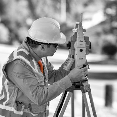
Builoff Surveying & M.. @BuiloffInc
10 Followers 18 Following Builoff Surveying & Mapping, Inc is a certified Small Business Enterprise that provides professional Land Surveying and Mapping services in Los Angeles area
Mapping Dubliners @MapDubProj
872 Followers 122 Following A map of all places and routes referenced in James Joyce's Dubliners. By @jasminemulliken PhD
Ministry of Mapping @mappingministry
2K Followers 210 Following serves the people with geospatial data, tech, and science through open and fair work. We are a collective cared for and owned by geospatial workers.
Open Mapping Hub - We.. @openmapping_wna
598 Followers 102 Following Stimulate and strengthen the leadership of communities to protect their livelihoods, improve their resilience, and preserve their way of life.
A-Z Digital Mapping @AZdigitalmaps
1K Followers 379 Following A-Z Digital Mapping is part of Geographers’ A-Z Map Company. With full coverage of GB we provide custom paper map and data services to all industries.
U.S. Cluster Mapping @ClusterMapping
382 Followers 6 Following
Mapping the Path @MappingThePath
5K Followers 3K Following Mathew Burns. #Travel narratives for big trips. SITE: Minor League Baseball road trips & European journeys by boat. NEXT: Eastern Midwest Baseball Road Trip
Digital Mapping @NearestYou
4K Followers 3K Following We build & manage store locator maps. We are launching a new Amazon / Shopify analytics tool to show CPG brands where they are selling their products.Outcome Mapping @outcomemapping
2K Followers 172 Following The Twitter home of the Outcome Mapping Learning Community. Get latest news and announcements. Beginner? Visit https://t.co/QXZFwiE1Vp
Mapping Atlanta @mappingATL
1K Followers 194 Following Atlanta's oddities and inequalities, but in maps. A project of @kyjts.
Geohazard Risk Mappin.. @GeohazardMaps
1K Followers 185 Following Providing simplified, high-precision flood hazard maps across Africa.
Apollo Mapping @ApolloMapping
2K Followers 1K Following The Image Hunters: High/med-res satellite imagery providers passionate about remote sensing, GIS, space, tech, geography, geology and Star Wars. Bike nerds.
CGG Satellite Mapping @CGGsatellite
1K Followers 397 Following Innovative satellite-derived mapping and monitoring solutions and access to the best imagery and elevation data
Mapping China @MappingChina
1K Followers 664 Following Mapping China is a young professional network dedicated to a political science based analysis of contemporary China.
Aboriginal Mapping @nativemaps
2K Followers 1K Following The Aboriginal Mapping Network: strategic resource for practitioners of traditional knowledge mapping around the world.
London Mapping Fest @lmfest
596 Followers 79 Following London Mapping Festival 2011-2012 is an exciting initiative that raises awareness about how mapping and related technologies are shaping our Capital.
WorldBrainMapping @WorldBrainMap
2K Followers 2K Following We study Neurosciences; driving science ahead to better patient care through molding new Tech & Therapies into life-saving diagnostic and therapeutic procedures
Mapping the Gay Guide.. @GayGuides
2K Followers 430 Following A new interactive digital history project exploring the history of queer spaces in America, by @regan008 & @EGonzaba. Grant funded thanks to @NEHgov
Mapping Museums Lab @MuseumsMapping
2K Followers 822 Following Research team gathering and analysing data on UK museums
Transit Mapping Sympo.. @transitmapsympo
333 Followers 19 Following The 4th edition of the Symposium will be held in Madrid on October 20-21, 2022!The Mapping Network @MappingNetwork
726 Followers 406 Following The Mapping Network is a nationwide group of professionals providing the Hydrographic / Sediment Surveys and UAV/Drone Mapping -FAA licensed sUAS remote pilots
Mapping Your Future @MYFinc
1K Followers 706 Following Mapping Your Future is a charitable, nonprofit that provides career, college, financial aid, and money management services. https://t.co/D93lw29tAz
BBC Web Mapping @webmapping
161 Followers 1 Following Barrow Councils Online Open Source Web Mapping
MappingPolitics @MappingPolitics
379 Followers 41 Following Links and comments on demographics and political geography. Also tweeting as @RobertDSullivan.
Open Mapping Hub - Ea.. @openmapping_esa
2K Followers 626 Following Advocating & facilitating #OpenMapData for disaster preparedness, #ClimateResilience and #SustainableCities.
Exotik Mapping @ExotikMapping
171 Followers 54 Following Mapping team in TM2020 founded by @Banano_TV in July 2021. We want to push and refresh the TM2020 competitive mapping as we all know it.
Advanced Radio Mappin.. @arm_hq
15 Followers 134 Following We measure people’s movement & behaviour @ events, stadiums, retail any “offline” location. We measure the real world.
Brooke E. Marston @mappingMarston
757 Followers 583 Following Terrainosaurus Rex | Cartographer at State Dept. | @NACIS Prez | Previously @NACIS_Atlas @OSUCartoGroup. Views are my own.
MappingImmigControv @MICresearch
1K Followers 1K Following Research project mapping the unfolding controversy of Home Office immigration campaigns. Based at University of Warwick & 6 other universities.
Indigenous Mapping Wo.. @imwaustralia
537 Followers 304 Following The #IMWau is a free geospatial training workshop for Aboriginal and Torres Strait Islander organisations and people. Organised by @WinyamaDigital
Squirl | Mapping Book.. @Squirlbooks
2K Followers 2K Following Bump into the places described in books with the Squirl app📍📚📲 - Authors, add your book’s settings for free (link below)!
Mapping Women's Suffr.. @mappingsuffrage
1K Followers 751 Following MWS brings together local and family researchers, academics and archivists, to create an unprecedented map of Votes for Women campaigners across England in 1911
プロジェクショ.. @PMAoJ
2K Followers 922 Following 世界最大級のプロジェクションマッピング国際大会@1minute_pm を運営。プロジェクションマッピングを用いたイベント企画、実施、コンサルティングなどを行っています。 We love Projection Mapping! We plan and support mapping projects.
Future Mapping Co. @Futuremaps
3K Followers 936 Following We create maps that take pride of place on any wall, using modernist colours and bold, innovative design. #MyFutureMap
Mapping Bar THE ROUTE @survivalroute
318 Followers 469 Following 3条通6丁目LC2号館6階 20:00〜LAST #バー #旭川 #スナック #年中無休 #コスプレ #カラオケ #アニソン #新店 #プロジェクター
Maptive Mapping Softw.. @Maptive
603 Followers 171 Following Make a free map from an address list or spreadsheet in seconds and gain insights immediately after.
Atlas Curriculum Mapp.. @planonatlas
2K Followers 2K Following Atlas is the leading curriculum planning platform designed to meet your school’s needs.
Mapping for Change @Mapping4Change
3K Followers 2K Following MfC is a social enterprise supporting the development of sustainable communities through research & participatory mapping with communities, Public Sector & NGOs
Exploration Mapping @ExplorationMap
23 Followers 29 Following
Trench, The Great War.. @TrenchFrontLine
542 Followers 369 Following Trench, The Great War Project 'A Social History Initiative for Local Communities'; 1901-21 #PayHistoryForward #FWW #LuvMaps #RollofHonour #CitizenHistoryProject
Claude (they/them) @mapping_edges
808 Followers 638 Following Mouth, full of prayers; possibility #trans #masc Oublie que très rarement l’heure du goûter

Anti-Eviction Mapping.. @antievictionmap
10K Followers 5K Following Digital cartography and storytelling collective creating maps, tools, and stories against displacement and gentrification. Anticapitalist, antiracist, always
Mapping Literary Teja.. @LiteraryTejas
874 Followers 655 Following #Chicanx #Indigenous #Latinx #Tejanx authors | cultural spaces | poets | publishers | small press | storytellers | writers |
PRISM Brain Mapping @PRISMBrainMap
736 Followers 480 Following PRISM Brain Mapping is the world’s most comprehensive, online, neuroscience-based #behaviour mapping tool.
Global Citizen IJ, On.. @MappingReveals
1K Followers 2K Following Fmr. Banker! Academic Scholar, Knowledge Transfer Expert, Spatial Data Scientist, Lover of Books & Maps, & Entrepreneur! Your Perceptions About me Don't Matter.