Search results for #PythonGIS

💡 Insights across health, urban planning, environment, and commerce are no longer static — they evolve with time and place. #SDSSN #TimeSeries #SpaceTimeAnalysis #HotspotDetection #Geospatial #GIS #ArcGIS #SaTScan #PythonGIS #Rstats


Day 28: 📡 Unleash the power of RADAR data in Python! Learn how libraries like Py-ART process and analyze RADAR data for weather, environmental, and geospatial applications. Decode the mysteries hidden in radio waves. 🌧️🌍 #RADARData #PythonGIS

Day 27: 🌐 Global reach with OGC standards! Learn how Python libraries like OWSLib enable seamless communication with geospatial web services adhering to Open Geospatial Consortium (OGC) standards. Foster interoperability in your GIS projects. 🤝🗺️ #OGCStandards #PythonGIS

Day 25: 🛰️ Space and Ground Unite! Dive into the fusion of satellite and ground-based data in Python. Leverage libraries like Skyfield to bridge the gap between celestial observations and geospatial analyses. 🌌🌍 Github Link: github.com/skyfielders/py… #SpaceData #PythonGIS

Day 24: 📈 Time to trend with spatiotemporal data! Learn how Python libraries like SpacePy and PySAL analyze trends over time and space. Uncover patterns and insights in dynamic datasets. ⏰🌍 #SpatiotemporalAnalysis #PythonGIS


Diving into #GIS training it's clear: mastering Python is like unlocking a superpower! Python is the key to transforming raw geographic data into insightful, actionable information, from automating data analysis to creating dynamic maps. #PythonGIS #GeoSpatial"

Day 3: 🌍 Mastering precision in GIS! Uncover the art of seamless coordinate transformations with the Pyproj library. Learn how to effortlessly convert between various coordinate reference systems for accurate geospatial analysis. 🌐 #GeoCoding #PythonGIS


🌍 Spatial Analysis of Population Shifts: A Deep Dive into Raster-based Exploration 🌍 spatial-dev.guru/2023/09/19/spa… #python #gis #gismapping #gisapplication #geospatial #geographicinformationsystems #spatial #esri #arcgis #xarray #geopandas #pythonprogramming #pythongis #shapely
Generate Heatmap using Datashader in Python and serve the heatmap tiles in OpenLayers map. #python #datashader #gis #gismapping #gisapplication #geospatial #geographicinformationsystems #spatial #esri #arcgis #xarray #geopandas #pythonprogramming #pythongis #shapely #OpenLayers
Merging multiple shapefiles into one shapefile using python and GeoPandas #python #gis #gismapping #gisapplication #geospatial #geographicinformationsystems #spatial #esri #arcgis #xarray #geopandas #pythonprogramming #pythongis #shapely spatial-dev.guru/2022/06/05/mer…

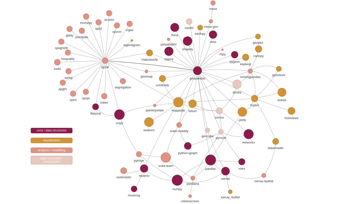
@pythongis @geopandas @pysal_devs @xarray_dev #2 version of the #PythonGIS universe is available here:
@pythongis @geopandas @pysal_devs @xarray_dev #2 version of the #PythonGIS universe is available here:

#2 attempt to map the #GeoPython #PythonGIS ecosystem for our @pythongis project. Currently 123 libraries covering a broader spectrum of pkgs. Thanks a lot for everyone who answered the call and helped! 🙏😎 Will produce separate for vector+raster & interactive ones to play with.
#2 attempt to map the #GeoPython #PythonGIS ecosystem for our @pythongis project. Currently 123 libraries covering a broader spectrum of pkgs. Thanks a lot for everyone who answered the call and helped! 🙏😎 Will produce separate for vector+raster & interactive ones to play with. https://t.co/WYSHJNGAeC
My first attempt to map the #GeoPython #PythonGIS ecosystem (currently n=69) for our @pythongis project (vector+raster) 🤓 𝐇𝐞𝐥𝐩 𝐧𝐞𝐞𝐝𝐞𝐝: What packages do I miss? I'm sure there are plenty of interesting libraries escaping my radar 🧐 @geopandas @pysal_devs @xarray_dev

PythonGIS @Pythongisofici1
20 Followers 2 Following Somos um grupo de programadores com ampla experiência no desenvolvimento de soluções relacionadas aos processos de automatização de tarefas em Python para SIG