
NextGIS @nextgis
Creators of full opensource geospatial stack: web server, mobile, desktop. Sign up at https://t.co/BNatzeFIj6. Discuss at https://t.co/PgA8Kl6k1J nextgis.com Joined October 2010-
Tweets1K
-
Followers1K
-
Following17
-
Likes65
Data for Business Intelligence and Geoanalytics We are pleased to introduce a new dataset available through NextGIS Data – points of interest. Use this dataset to get insights for market analysis, site selection, planning and development. Learn more: nextgis.com/blog/poi/

Painless QGIS plugin development with a new DevTools plugin for QGIS. Connect and debug with VSCode or Visual Studio github.com/nextgis/qgis_d…
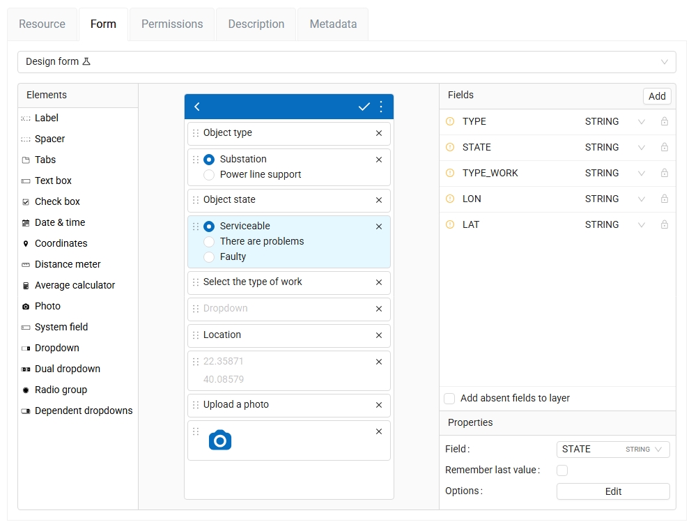
Create mobile forms in your web browser With the recent NextGIS Web update you can choose between several ways to create a data collection form for your mobile app: — Build a form directly in Web GIS — Upload a NGFP file — Create a form+new layer from desktop Formbuilder
NextGIS Web 5.1 We're excited to introduce the latest version of NextGIS Web! We invite you to explore the new features and would love to hear your feedback and suggestions. Learn more: nextgis.com/blog/ngw-5-1/

Today, it's fast and easy to access building footprint data using AI-mapped solutions. One quick and affordable option is offered by @nextgis at a very low cost: data.nextgis.com/es/region/cust… #OpenData #AI #DisasterResponse #GIS #HumanitarianTech

Today, it's fast and easy to access building footprint data using AI-mapped solutions. One quick and affordable option is offered by @nextgis at a very low cost: data.nextgis.com/es/region/cust… #OpenData #AI #DisasterResponse #GIS #HumanitarianTech

MOLUSCE 5 released! We have updated MOLUSCE – QGIS tool to analyze and predict land cover changes. The most important update in MOLUSCE 5.0 is the ability to use different spatial variable layers during the training and prediction stages. youtu.be/GVrk_uLJbuA
🌎 Global Landcover Data on NextGIS Data! Three high-resolution (10m) global landcover datasets are now available on NextGIS Data. Choose from ESRI Land Cover, ESA WorldCover, or Dynamic World. Learn more: nextgis.com/blog/landcover…
Wurman Dots 2.0 for QGIS We added a new mode that generates a grid based on cell count. Now you have two options how to create a grid: — define the size of a cell; — or define the number of cells (along the shorter side of the input point layer's extent).

Projects for ArcGIS Pro on NextGIS Data Now you can get a ready-to-go project for ArcGIS Pro when you order OSM basemap data in Geodatabase format. Soon this option will be available for the other data set types too. Order data: data.nextgis.com/en/

Add multiple styles at once By popular demand, now you can add several vector layers to a Web Map at one go, even if they are in different groups. Navigate between groups and select styles. Our new picker remembers all the selections, so you only need to do it once.
🆕 NextGIS Web 5.0 New version of NextGIS Web is available for on-premise users! Find out all about the latest improvements in our post: nextgis.com/blog/ngw-5_0/?…
NextGIS Tracker: a simple tool to record and publish GPS tracks ✅ Record your movements as GPS tracks ✅ Auto-sync them with a cloud-based or on-premise Web GIS ✅ Export tracks as GPX files Get a Google Play link or an APK on our website: nextgis.com/nextgis-tracke…

Ever seen this? Updated QuickMapServices now uses internal QGIS Network Access Manager. Hopefuly less problems with connectivity.

Spatial data for cultural heritage sites now available on NextGIS Data! Select any area of the world and order data in a format of your choice. With the data you get a ready-to-go GIS project. Learn more: nextgis.com/blog/heritage-…

📱NextGIS Mobile 2.9.2 & NextGIS Collector 1.9.0 – Time to Update! The new version allows you to view photo attachments added earlier to the features and stored in the cloud. We've also fixed some issues to improve app performance.

New QuickMapServices for #QGIS is released with Qt6 support

Improvements in NextGIS Connect for QGIS are in full swing! That’s why version 2.6.0 arrived so quickly. What’s new: — You can now search for resources by URL. — The authentication dialog has been simplified. Learn more about NextGIS Connect: nextgis.com/nextgis-connec…


Welcome to Map Style Gallery! A collection of ready-to-use beautiful styles: nextgis.com/map-styles/?ut…
Add Coordinates to Images Using Track Introducing our online tool that adds location data to your photos using a GPX track of your route: nextgis.com/blog/gpx2exif/…

Mapping Object Density with Wurman Dots We’ve developed a new Wurman Dots plugin for QGIS. It helps visualize the density of objects in a point layer. Check out our article for a detailed explanation and a demo video: nextgis.com/blog/wurman-do…

Kurt Menke - @geomenk... @geomenke
8K Followers 2K Following Danish Resident 🇩🇰 | @SeptimaDK | FOSS4G user/advocate/educator | Author: Discover QGIS 3.x 2nd Ed. | Co-author:QGIS for Hydrological Applications 2nd Ed.
Hans van der Kwast @h... @hansakwast
8K Followers 2K Following For GIS related posts find me in the fediverse and where the sky is blue! @qwast-gis.com
Alexandre Neto @AlexNetoGeo
3K Followers 579 Following Father of three, Husband, Open Source advocate, OS spatial evangelist, WIP developer, cartographer, and a proud geek. @[email protected]
Topi Tjukanov @tjukanov
20K Followers 2K Following Makes maps. Works at @Mapbox. Started #30DayMapChallenge.
@rjhale1971@fosstodon... @rjhale
4K Followers 3K Following Owner of @northrivergeo . Enjoys adventuring, canoeing, and long walks on the beach while fixing data. #QGIS #POSTGIS #GDAL #GEOSERVER #CHATTANOOGA #HASHTAG
Simon Kuestenmacher @simongerman600
258K Followers 216K Following German #geographer and #demographer in #Melbourne. I curate #maps and #data that explain how the #world works. Obviously all opinions are my own...
Nick Bearman @NickBearmanUK
3K Followers 4K Following GIS Trainer & Consultant; now also at https://t.co/sUy1FfAdBW, Cartographic Editor @cartographyGIS; cartography, open data, QGIS, R, https://t.co/Oai7kIeuka
Patricio Soriano @SIGdeletras
3K Followers 1K Following "Full-stack" geographer, web developer, and "cordobé"
Cesium @CesiumJS
11K Followers 9K Following The Platform for 3D Geospatial. Tile, visualize, contextualize, and analyze your 3D data. #3DTiles #WebGL
Evelyn | @evelynuuema... @evelynuuemaa
2K Followers 434 Following Geographer and Professor in Geoinformatics @unitartu, Head of the @LGeoinformatics Lab. Geospatial and open data enthusiast, foodie and coffee junkie :-)
Sidney Schaberle Gove... @sidneysgoveia
2K Followers 726 Following FOSS4G, QGIS, GRASS GIS, R, PostGIS @[email protected]
Mykola Kozyr 🇺🇦... @MykolaKozyr
1K Followers 857 Following #StandWithUkraine Space-tech and geospatial. Product at @satellitevu. Earlier - @UP42_ @eos_da Views are strictly my own.
nplus1 @sblaisfernandez
0 Followers 6 Following
Rotaract District 911... @RotaractD9111ng
64 Followers 12 Following Official account of Rotaract District 9111 Nigeria. Youth wing of Rotary and a humanitarian Organization covering 43 Clubs.
Sricharan Srivatsa @meesacharan
200 Followers 2K Following Enjoy watching fluid football I Data Viz Noob I
oswaldo alba @oalba74
41 Followers 344 Following
Idara Eniang @Idybuoy
5 Followers 37 Following Digital development specialist | GIS, web & content strategy | Using tech to solve problems, support causes & make an impact 🌍💡

Francis Asante Nsiah @Nsiah_Asante
82 Followers 294 Following #Quality Assurance, Agile & Scrum , API Testing, Cypress #GIS Analyst, Geography, OpenStreetMapper, Cartography, Geospatial #GhanaianSignLanguageInterpreter
Rem @Remykiwi78
39 Followers 154 Following
NOAH KERTICH @noahkertich
589 Followers 1K Following GIS, SURVEYING & MAPPING ENTHUSIAST. Say NO to smoking barrels & live in PEACE. Making peace with GEO-TECHNOLOGY השלום השלום השלום.

AREEJ MAHMOUD.👩... @AM2062000
8 Followers 311 Following إن الروح إذا إلتقت بمن يشبهها ترمّمت، وتعـافت، واكتملت💖
Evgeny @materov
4 Followers 130 Following
Salva @chavicosoficial
149 Followers 2K Following Just a person who loves to live, to be part of this amaizing world, and classic man with no standars. Plese follow me.
Nurçin Çelik @nurcincelikk
5 Followers 1K Following
N6ix-Richmond @mhqml_Gh
325 Followers 517 Following THE STRUGGLES KEEPS ME too HARD, HOPE SUCCESS SOFTENS ME SOON. - @lakers -@Barca -Tech -Earth -humanly possible - MuG
abdullah @abdollahmps
101 Followers 1K Following
Christian Guido @ChristianGuido
134 Followers 878 Following Databases, Analytics, and Web 💽📊🌐 | FL🐊 ➡️ TX🤠

LuisFarming ® @PyFarming
2K Followers 5K Following Smart Farming Analytics Agricultural remote sensing 🛰 🌎| Cartographer | SIG | FS19 | Python 🐍 | 🇨🇱 Nature is cyclical 🌎 #DeepAgro
Radica🗼 @iamradica
85 Followers 193 Following Expert Crypto, future Billionaire..⛏ 💰 Get Full Analysis & Latest Updates of Crypto Mining ⛏️ APPs.|Web.3 🕸️ Blockchian🧊World New🧾Cruise😀 Stake🎳🏂
György Csorba @leves502
49 Followers 161 Following
oke oluwaseun @sammy4christ
275 Followers 1K Following Enjoy what I do a football lover and a passionate arsenal fan....
B A B y @ole_z33
998 Followers 1K Following
Salami.B.L @Salamichino
57 Followers 1K Following
Roberto Adaro @robertoadaro
632 Followers 3K Following En la búsqueda de ese Camino, que se hace al andar... ex Subse de Investigación Científica y Política Industrial para la Defensa
NGETICH @KipngetichKait1
307 Followers 324 Following GIS, GEE, RS,Civil3D, Remote Sensing in Agriculture


David @Dv_Zamora
280 Followers 4K Following 🍀Caleño | Sociólogo de la @Univallecol🦉: #DatosAbierto #OpenData📊📈 RT !== 👍🏽
Hasan Hicsasmaz @yellowexpo
95 Followers 848 Following

Mickey @mike65395
379 Followers 3K Following Geospatial Developer/Remote sensing/Land Survey/Cartographer
💙🥰سيدي ال... @bbboubacar03
559 Followers 1K Following Jërëjef Serigne Babacar Sy 🙏🏽🥰 Amo morom😇 #Geography #Climatology #Geomatic 🌍💫 #Environnement 🌱 Win~Lose~Tie i'll always support #CHELSEA 💙💪🏼
La ciudad no se manch... @ciudadnomancha
369 Followers 2K Following La ciudad no se mancha, ideas para transformarla

Domhnall @VaPotiwa
586 Followers 2K Following Honor all people. Love the brotherhood. Fear God. Honor the king. #ForEverStill
BNC Geomatics Ltd. @Bncgeomatics
27 Followers 215 Following Professional engineering and #Topographic Surveyors, #Drone and #Lidar mapping specialists, in #Zambia

Pascal Awenjaab Walte... @pascalgbiel
1K Followers 5K Following


Omollo @f_omolloh
73 Followers 155 Following Geospatial Analyst🌍🛰️. Addicted to RS & 3D modeling #GIS #Python #RemoteSensing #SpatialDevelopment #spatialsolutions
Abhinav Kumar Mishra @Abhinav_74
42 Followers 381 Following Ph.D Student @ CSRD, JNU. Interested in Geography, Urban Planning and Regional Development issues, Sports and Tourism.
B @Ben45746798
10 Followers 1K Following

regiser @Iamregiser
48 Followers 3K Following
Roman Gainullov @GainullovR
1 Followers 3 Following
Anastasiya Lisovenko @AnastasiyaLiso8
5 Followers 227 Following
Eduard Kazakov @ee_kazakov
25 Followers 90 Following Cartography, geoinformatics and Earth remote sensing specialist


Dr Jordan B Peterson @jordanbpeterson
6.1M Followers 2K Following Best-Selling Author | Clinical Psychologist | #1 Education Podcast | Co-founder of @petersonacademy | Order my new book "We Who Wrestle With God" here:
Nassim Nicholas Taleb @nntaleb
1.1M Followers 2K Following Flaneur: probability (philosophy), probability (mathematics), probability (real life),Phoenician wine, deadlifts & dead languages. Greco-Levantine.Canaan. #RWRI
Boris @SirFlyingV
116 Followers 501 Following guitar in @dehyperband, Frontend developer, GIS specialist, mountain biker who yet never been in mountains with bike https://t.co/3Hm3ynncYN

Артемий @Rendrom
3 Followers 9 Following

trolleway.com @trolleway
2K Followers 654 Following чат про катания на электричках: https://t.co/HTU29dyALa high-res photos: https://t.co/ONS4IUNMKl
Kolesov Dmitry @kolesov_dm
11 Followers 14 Following
Dmitriy Baryshnikov @GisBishop
102 Followers 16 Following
Denis Rykov @rykovd
92 Followers 166 Following

Trends for United States
You might like