
Marc Jansen @selectoid
Application developer (geospatial applications) selectoid.wordpress.com Bonn Joined November 2009-
Tweets2K
-
Followers595
-
Following354
-
Likes549

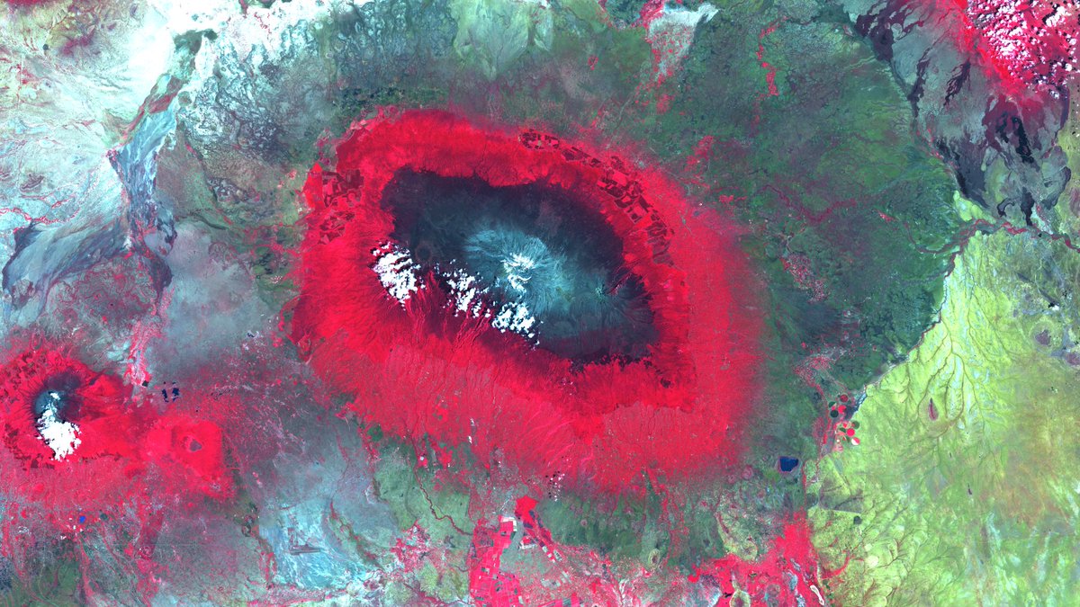
Stunning colours on the slopes of #MountKilimanjaro in #Tanzania. Visit our satellite image of the month May on: mundialis.de/en/satellite-i… Made with #OSGeo #Sentinel2 #Copernicus #satelliteimageofthemonth #Africa #vegetationzones #opendata #opensource
Our latest satellite image of the month shows the artfully meandering #AdelaideRiver in #Australia: mundialis.de/en/satellite-i… made with #OSGeo Now also with geo-localisation by @terrestrisde ! #Sentinel2 #Copernicus #satelliteimageofthemonth #NorthernTerritory #opendata #opensource

Wir & @terrestrisde sind nach DIN EN ISO 9001:2015 und DIN EN ISO 14001:2015 zertifiziert! 🌐🌱 Diese Meilensteine unterstreichen unser fortwährendes Streben nach Exzellenz und nachhaltiger Entwicklung: mundialis.de/qualitaets-und… #Qualitätsmanagement #Umweltmanagement
Two releases on one day! A 7.5.2 patch release fixing an issue with vector hit detection, and the exciting version 8.0.0 with several API improvements and the new StadiaMaps source replacing Stamen. Thanks to everyone who contributed! github.com/openlayers/ope…
OpenLayers 7.5 is out with a batch of great features and 10 first time contributors! Check out the release notes for details github.com/openlayers/ope…
@PhenoRob #careerfair im Universitätsclub Bonn. Mit @MundialisInfo und @terrestrisde. Wir freuen uns auf eine tolle Veranstaltung mit vielen interessanten Menschen 😊

#frischeKarten aus dem #Basemap-Labor: Unsere #3D-Beta-Dienste (basemap.de/beta_produkte_…) sind nun online! Es handelt sich um eine deutschlandweite 3D-Visualisierung auf Grundlage von #DGM5 und den #LOD2-Daten der Länder. #Karten #amtlich


Die Folien von unserem Vortrag "Geodatenanalyse in der Cloud - OGC API Processes und pygeoapi" von C. Mayer und H. Blitza (@terrestrisde) sind online verfügbar. ➡️ klips-project.github.io/fossgis2023/ #FOSSGIS2023 @pygeoapi @opengeospatial

Thanks to everyone who attended! Slides online at terrestris.github.io/fossgis2023/ta…

Slides for the @openlayers Feature Frenzy from @ahoce and me at #FOSSGIS2023 terrestris.github.io/fossgis2023/ta…
OpenLayers 7.3 is out just in time for your Saturday night mapping session! Some nice rendering and editing performance improvements in this release. Thanks to those who contributed, including 5 new first time contributors! github.com/openlayers/ope…
Die AG Smart Mapping informiert am 09.03.2023 alle Interessierten über die aktuellen Entwicklungen im Projekt. Zugangsdaten zur Videokonferenz über: basemap.de/projekt_worksh…

Danke Sponsoren @FOSSGIS_Konf @camptocamp @WhereGroup_com @HumboldtUni @BKG_Bund @OPENGISch @terrestrisde @komoot @MundialisInfo GEOINFO AG @sourcepole @FiveTwoN @OpenCage Wagner-IT Geoinformatikbüro Dassau @latlon_de GKG-Kassel - Claas Leiner @geofabrik d.b.g. mbH @geoSYSnet !B

OpenLayers v7.20 is out \o/ github.com/openlayers/ope… … new features, perf. optimisations, interoperability++ (😍 OGC API - Tiles support) and *much* more. Thanks to all contributors!
Nur noch heute - Call for Participation @FOSSGIS_Konf: bit.ly/3UWVS4F Die #FOSSGIS2023 (15.-18.03.2023 in Berlin) ist die Communityveranstaltung für #OpenSource und #OpenData im Geobereich. #FOSSGIS #OSM #OSGeo


The European Space Agency @esa proudly announces the release of the WorldCover2021 map based on Sentinel-2 & Sentinel-1 constellations with 11 classes, 10m resolution, 77% accuracy independently validated Visit worldcover2021.esa.int @esa_EO #EuropeanSpaceAgency #WorldCover2021

Our latest satellite image of the month shows a #WorldHeritageSite: The #GrandCanyon in #Arizona, #USA. Have a look at mundialis.de/en/satellitenb… made with #OSgeo #Sentinel2 #Copernicus #satelliteimageofthemonth #NorthAmerica

Auf der #FOSSGIS2022 zeigten wir, wie wir freie #Klimadaten und #Wetterdaten für #GIS-Anwendungen nutzbar machen. Danke für das Feedback! Vortrag: media.ccc.de/v/fossgis2022-… / Beitrag (S. 197 ff.): files.fossgis.de/Konferenz/foss… /cc @selectoid @FOSSGIS_Konf @terrestrisde @figura_richard


OpenLayers @openlayers
16K Followers 18 Following An open source JavaScript library for creating interactive maps from any kind of geospatial data
Thomas Gratier - @Tho... @ThomasG77
3K Followers 5K Following Freelance SIG libres, OSM & OpenData /w JS & Python. Auteur livre OpenLayers. Pro @webgeodatavore + https://t.co/eriVmUePcG Coopère @ouvreboites44
@rjhale1971@fosstodon... @rjhale
4K Followers 3K Following Owner of @northrivergeo . Enjoys adventuring, canoeing, and long walks on the beach while fixing data. #QGIS #POSTGIS #GDAL #GEOSERVER #CHATTANOOGA #HASHTAG
FOSS4G 2024 | https:/... @foss4g
18K Followers 592 Following The world’s largest gathering of open source geospatial users, developers, and researchers. FOSS4G | https://t.co/wtkKL1RgOW
@[email protected] @howardbutler
5K Followers 2K Following Point clouds. Open source. PDAL, GDAL, Entwine, https://t.co/7SpD598uPq, libspatialindex, and others. non-contributor corporate entity leading @hobuinc
#geoObserver 🌍🔭... @geoObserver_
2K Followers 1K Following 1. Brauchen wir keinen Raumbezug und 2. ist die Erde eine Scheibe. 1. we do not need a spatial reference and 2. the earth is a disc.
FOSSGIS Konferenz @FOSSGIS_Konf
1K Followers 131 Following FOSSGIS Konferenz 2024 vom 20-23.März 2024 • Hamburg • Online • Impressum: https://t.co/tN2AmVwxtV #FOSSGIS #FOSSGIS2024
Mapbender | @mapbende... @mapbender
838 Followers 13 Following Mapbender is one of the leading open source solutions for creating intuitive and high-performance WebGIS applications. Also at https://t.co/UT9AcArAMz
Jeff McKenna @mapserving
6K Followers 3K Following Co-founder of FOSS4G, Director of GatewayGeo, President Emeritus of OSGeo. Sharing maps with MapServer & MS4W, offering support-dev+generally having fun in life
Humanitarian OpenStre... @hotosm
28K Followers 2K Following Reposting key info from our Open Regional Hubs here. For updates, follow us in Bluesky at @hotosm.org
OSGeo https://fosstod... @OSGeo
30K Followers 186 Following The Open Source Geospatial Foundation... search for our local chapters around the world as well. See you at https://t.co/mCjhOCQaoy
Arunava Chowdhury @arunava_xylene
14 Followers 281 Following Hard work doesn’t bother me. I actually like it. My name is Arunava Chowdhury.

XavieraSophia @My95G8QB6jrlZgJ
76 Followers 3K Following
Sylvie Dublque @SDublque
2 Followers 124 Following
soidadios @sodiadiosken
0 Followers 11 Following
Drorsli @DrorsliwPN8d
41 Followers 4K Following
Gail @DisoreLxNfPMx
29 Followers 1K Following Many people say that marriage is the grave of love, but love that can be buried in the earth is better than that on the streets of murderers.


Alireza Kian @AlirezaKian12
0 Followers 24 Following
wil @Gy08999
63 Followers 2K Following
snneko @snneko
550 Followers 1K Following Data Analyst @mercari_jp @mercarihallo (since 2024.08). Stray cat who likes geospatial data science. 位置情報分析と機械学習が好きな野良猫です.

TerraOps - Innovation... @TerraOpsOrg
5 Followers 82 Following TerraOps specializes in geospatial cloud solutions of OsGEO/FOSS4G stack, offering expert OsGEO software implementation, REST API services, using DevOps methods
A-Kian @kian83468883
6 Followers 83 Following
MapMyAfrica : Pan-Afr... @MapMyAfrica
40 Followers 402 Following MapMyAfrica champions Geospatial Intelligence, Geospatial Awareness, Geospatial Infrastructure, Geospatial Economy, Digital Twins in Countries, Cities in Africa
MD sanjid @md45149
55 Followers 498 Following I am graphic designers and working based on photo into illustration like, Watercolour Illustration,t, Digital painting. Also i am creating Typography designe .
Alex Makhaev @mankms
10K Followers 9K Following I work hard on https://t.co/Xx3Q0DzVeL and enjoy building https://t.co/oAbu1LbRlw (or vice versa). Unsure about the work/life dilemma. Primarily startup engineering focused on X.
McSedote @MSedote36282
12 Followers 93 Following
Müller Patricia @mullapatricia33
31 Followers 411 Following

XYZ @zhangasync
368 Followers 5K Following CAT PERSON | FOSS4G | Full stack WebGIS developer | Friend of two cats | こんにちは | 请多指教 | I’m learning English and Jp ,fell free to correct me
geospatialtechno @geospatialtechn
27 Followers 73 Following This channel, learns you how to use #GeoServer software to create GeoSpatial web services and learn OGC standards.

Maptoolkit @maptoolkit
234 Followers 87 Following Geo APIs for developers. Makers of https://t.co/Pz1ErUtUnd & @printmaps. Developers of @maplibre 3D, members of the @openstreetmap Foundation.
Brian Goldin @briangoldin
117 Followers 416 Following
Henning @henning3
12 Followers 173 Following
Stefan Hahmann @stefanhahmann
194 Followers 404 Following geoinformatics, bio image analysis, science & beyond

Codrina Maria Ilie @CodrinaI
681 Followers 404 Following Open Data, Open Source, maps and such. #FOSS4G2019 program chair. Views my own.
Amelia Amelia @AmeliaAmelia113
5 Followers 75 Following Enabling organizations to efficiently manage their data and analytics in today's ever changing environment.
HOICKO @hoicko_official
217 Followers 351 Following https://t.co/mcBGLafn37 Streamlining HRMS, CRM, Project, Task Management. Boost productivity Signup: https://t.co/pz1iEVL6gl connect with us on call: +91-7627029423
geo.admin.ch @swiss_geoportal
6K Followers 469 Following Geoportal Bund: The #geoportal of the #federal authorities of the #Swiss Confederation [email protected] #maps #switzerland Likes + RT are not endorsements

LayerStack @LayerStackCloud
658 Followers 729 Following Asia's leading cloud service provider that delivers a wide range of professional cloud computing solutions.
Benjamin Loesch @beniLoesch
43 Followers 195 Following
Allart @allartk
32 Followers 257 Following
(((joseph miller))) @japm1976
28 Followers 755 Following
CISS TDI GmbH @ciss_tdi
25 Followers 14 Following Geodaten. Universell. Nutzbar. Für eine nachhaltige und digitale Gesellschaft.
Cesium @CesiumJS
11K Followers 9K Following The Platform for 3D Geospatial. Tile, visualize, contextualize, and analyze your 3D data. #3DTiles #WebGL
Guido @_Le_Guide
10 Followers 163 Following


ingenieroariel @ingenieroariel
611 Followers 947 Following Geospatial Software Developer, my car is NixOS, Pythonista, (geo)Djangonaut, Happy husband, Proud father.
Vani 🔜 @ Oktofest @rt__Vani
543 Followers 360 Following former Splatoon player • nur der BVB 💛🖤 • @Dive_Spl forever 🫂 • @Marky_4k 🫶
Martin Finder @Martin_Finder
0 Followers 1 Following
Radiator @Radiator1981
21 Followers 3K Following
Luise Zitz @LuiseZitz
0 Followers 4 Following
Volodymyr Agafonkin �... @mourner
15K Followers 1K Following Engineer at @Mapbox, creator of @LeafletJS, open source enthusiast, algorithms geek, speaker, musician @obiymydoschu, baker, father of twin girls, Ukrainian
OpenLayers @openlayers
16K Followers 18 Following An open source JavaScript library for creating interactive maps from any kind of geospatial data
Thomas Gratier - @Tho... @ThomasG77
3K Followers 5K Following Freelance SIG libres, OSM & OpenData /w JS & Python. Auteur livre OpenLayers. Pro @webgeodatavore + https://t.co/eriVmUePcG Coopère @ouvreboites44
Open Geospatial: OGC @opengeospatial
27K Followers 230 Following OGC’s member-community of experts makes location data Findable, Accessible Interoperable, and Reusable (FAIR) through #innovation #collaboration and #standards
FOSS4G 2024 | https:/... @foss4g
18K Followers 592 Following The world’s largest gathering of open source geospatial users, developers, and researchers. FOSS4G | https://t.co/wtkKL1RgOW
Paul Ramsey @pwramsey
7K Followers 232 Following Please find me at @[email protected] @pwramsey.bsky.social
GeoSolutions 🇮🇹... @geosolutions_it
7K Followers 262 Following GeoSpatial solutions based on @GeoServerO, @GeoNode, @MapStore2, #GeoNetwork and other Geospatial Open Source projects.
QGIS @qgis
64K Followers 63 Following Official account of QGIS - the user friendly Open Source Geographic Information System
@[email protected] @howardbutler
5K Followers 2K Following Point clouds. Open source. PDAL, GDAL, Entwine, https://t.co/7SpD598uPq, libspatialindex, and others. non-contributor corporate entity leading @hobuinc
https://bsky.app/prof... @tmcw
15K Followers 2 Following not using twitter anymore. https://t.co/PtubFCpGBJ https://t.co/ZckGEmD0Ob https://t.co/Bq05CWsrnj
#geoObserver 🌍🔭... @geoObserver_
2K Followers 1K Following 1. Brauchen wir keinen Raumbezug und 2. ist die Erde eine Scheibe. 1. we do not need a spatial reference and 2. the earth is a disc.
Jody Garnett @jodygarnett
2K Followers 312 Following Open source geospatial contributor with @osgeo and @locationtech communities. Projects include GeoTools, GeoServer, JTS, ImageN and uDig.

MapScaping @MapScaping
37K Followers 115 Following The MapScaping Podcast is a #podcast for the #geospatial community. Just search for "MapScaping" Wherever you get your podcasts!
David Bitner @bitnerd
1K Followers 901 Following @[email protected] Ultra Runner/Coach/RD - https://t.co/9E0DB36yyr Geo/FOSS/Database Dev https://t.co/mt0C9HPd8q & https://t.co/Zy70ik22sp he/him
FOSSGIS Konferenz @FOSSGIS_Konf
1K Followers 131 Following FOSSGIS Konferenz 2024 vom 20-23.März 2024 • Hamburg • Online • Impressum: https://t.co/tN2AmVwxtV #FOSSGIS #FOSSGIS2024
@erle.bsky.social @schuyler
2K Followers 1 Following All these moments will be lost in time, like tears in rain. https://t.co/ciE3Redivs · https://t.co/tPGWAsX1aS
Mapbender | @mapbende... @mapbender
838 Followers 13 Following Mapbender is one of the leading open source solutions for creating intuitive and high-performance WebGIS applications. Also at https://t.co/UT9AcArAMz
Jeff McKenna @mapserving
6K Followers 3K Following Co-founder of FOSS4G, Director of GatewayGeo, President Emeritus of OSGeo. Sharing maps with MapServer & MS4W, offering support-dev+generally having fun in life
Pikaso @pikaso_me
940K Followers 19 Following 1️⃣ Follow me 2️⃣ Reply to any tweet 3️⃣ Write "@pikaso_me screenshot this"
Sebastian Goetsch @pokerface_2001
10 Followers 143 Following
basemap.de @BasemapDE
274 Followers 436 Following flexible und moderne #Karten, #opensource, alles #amtlich und hauptsächlich fürs Web - Tweets vom Entwickler-Team der https://t.co/Q0VCtV1VnI Kontakt: [email protected]
Henning @henning3
12 Followers 173 Following
Marjan Van de Kauter @Marjan_VdK
122 Followers 233 Following language & communications geek 🗣 film & tv freak 📽 music fan 🎼 mom of 2 🐣🐣 OSM enthusiast 🌍 (she/her)
CISS TDI GmbH @ciss_tdi
25 Followers 14 Following Geodaten. Universell. Nutzbar. Für eine nachhaltige und digitale Gesellschaft.
Cesium @CesiumJS
11K Followers 9K Following The Platform for 3D Geospatial. Tile, visualize, contextualize, and analyze your 3D data. #3DTiles #WebGL
Codrina Maria Ilie @CodrinaI
681 Followers 404 Following Open Data, Open Source, maps and such. #FOSS4G2019 program chair. Views my own.
Literatur und Kunst @Karin_schreibt
2K Followers 2K Following Autorin + Künstlerin Neubeginn im Münsterland. @[email protected]

Nicklas Avén @NicklasAven
280 Followers 564 Following
jacmendt @jacmendt
103 Followers 216 Following Interested in all applications of environmental and spatial data, coach of a basketball team, founder of @pikobytes
Sparkgeo @sparkgeo
2K Followers 2K Following Companies partner with us to make sense of location. We help them with geospatial analytics, expert insights, and custom software development.
Torsten Friebe @torfri
72 Followers 162 Following #agile #scrum #java #springframework #opensource #deegree @deegree_org @latlon_de
gdaltips @gdaltips
2K Followers 171 Following The Geospatial Data Abstraction Library (GDAL) is a computer software library for reading and writing raster and vector geospatial data formats. #tips #tricks
Richard Bischof @GeoCloudChaser
48 Followers 218 Following Developer, Visionary & Disruptor @ LGLN - views are my own.

Bundesamt für Kartog... @BKG_Bund
6K Followers 838 Following 🌐 Zentraler Geo-Dienstleister des Bundes. #WirGebenOrientierung Impressum: https://t.co/hLQLQUd4Zy Netiquette: https://t.co/FkKlA0KWGx
The White House 45 Ar... @WhiteHouse45
23.6M Followers 12 Following This is an archive of a Trump Administration account, maintained by the National Archives and Records Administration.
Hans Niemann @HansMokeNiemann
83K Followers 487 Following early access to the future of chess: https://t.co/4dBkUp3B02
Hikaru Nakamura @GMHikaru
624K Followers 411 Following Proudly Team Falcons Chess Professional Content Creator Business email: [email protected]
Kamala Harris @KamalaHarris
20.8M Followers 702 Following Always fighting for the people. Wife, Momala, Auntie. She/her. 107 Days available for pre-order now.
Joe Biden @JoeBiden
38.1M Followers 46 Following Husband to @DrBiden, proud father, grandfather, and great grandfather.
Risklayer @risklayer
49K Followers 261 Following Risklayer is a transparent & independent collaborative catastrophe risk firm in Germany & Australia. Tweets from @JamesEDaniell, @JohannesBrand98.
Sören Horn @SoerenHorn85
28 Followers 134 Following Freelancing GIS Consultant • Webmapping & OpenSource Enthusiast • Husband & Dad
XKCD Comic @xkcdComic
338K Followers 1 Following XKCD comic feed with images and mobile friendly links. Unofficial, feed run by @dghubble
Katja Dörner @katjadoerner
19K Followers 536 Following Oberbürgermeisterin der Bundesstadt BONN / MdB 2009 bis 2020 (twittere selbst)
M.C. Escher @artistescher
75K Followers 304 Following Maurits Cornelis Escher was a 20th century Dutch artist who made woodcuts, lithographs, and mezzotints. #artbots by @nuwaves_future

André Neumann @AndreNeumannABG
4K Followers 591 Following Altenburg Thüringen | Oberbürgermeister | CDU | Privater Account
rKlemm @GeoKlemm
61 Followers 165 Following cartographer | remote sensing | #GIS | #routing | geodesign | #android | #OSM | #postgis | #mapserver | #qgis | #webgis | #vectortiles | @WhereGroup_com
Maurer-Stutz-Geo @maurerstutzgeo
261 Followers 102 Following Go beyond traditional GIS by integrating innovation with industry-leading expertise. Explore how we can help you see your projects from a whole new perspective
GISolutions @solutions_gi
30 Followers 114 Following GISolutions - Ihr Partner für Open Source Geoinformation. OpenGIS as a Service, #QGIS, #PostGIS, #OpenLayers, #OSM, #DockerMicha @hutzelknecht
35 Followers 76 Following forest fugitive, swabian javascribbler, coffee prosumer, code gardner.
GRASS @GRASSGIS
5K Followers 210 Following GRASS news, tutorials, and other resources on geospatial. Also at https://t.co/oVs3uafsUf (@[email protected]) #GRASSGIS #OSGeo
Ant Scott @antscott
499 Followers 515 Following
(((TheSteve0))) @TheS... @TheSteve0
4K Followers 2K Following This site is just reposts from Mastodon. I do tech stuff, love fishing, birding, stats, ecology, and GIS. Come join me at: @[email protected]
Alastair 💙🇪🇺... @ajgwords
2K Followers 1K Following #geography, #environment, #retrofit, #renewables, #earthobservation, #opensource 📡🛰🌍 some #politics Born at 333 ppm CO2 (26% ⬇ than now). Ex-@eoscenefrom
walkermatt.log @_walkermatt
564 Followers 469 Following 🦣 @[email protected] I like bicycles and building things with software; geospatial thingy-me-jig at Astun Technology. SEND Governor at @Wolverley_SAET
Maptiks @maptiks
4K Followers 4K Following Web Map Analytics built by @sparkgeo - works with #Mapbox, #LeafletJS, #OpenLayers, #Mango, #GoogleMaps, #Esri.
Olivetreehouse Mani @OlivetreehouseM
10 Followers 15 Following I am a holiday home on the Messinian Mani, Peloponnes, close to Agios Nikolaos, located in an olive tree grove ...
HERMOSA by mundialis @hermosa_earth
76 Followers 45 Following Holistic Ecosystem Restoration Monitoring, repOrting, Sharing and mArketplace
👋 👉 @Sascha@Bon... @Sascha_Foerster
3K Followers 1 Following Ich bin jetzt auf https://t.co/JvhVuJzOhC und nutze Mastodon: https://t.co/za07lxhgcJ Komm gerne rüber!
new name @kleinergoth
17 Followers 65 Following
BIG @BIGCLANgg
149K Followers 301 Following Best in Germany. Home to world-class athletes in the most prestigious esports titles. 🇩🇪 #GOBIG
BIG Massa @BIGmassaTM
13K Followers 487 Following Professional Player for @BIGCLANgg 🇩🇪 https://t.co/JMQjJajq2C
INTERGEO @InsideIntergeo
4K Followers 530 Following 24 - 26 September 2024 | STUTTGART | The World's No.1 Event for the Geospatial Community | Digital Twins, Digital Mapping, BIM, Smart City, UAV
Klara Geywitz @klara_geywitz
19K Followers 3K FollowingTrends for United States
You might like