Mapzest @MapZest
Geospatial technology | Mapping | Remote sensing and GIS | Machine learning Joined February 2023-
Tweets14
-
Followers17
-
Following102
-
Likes70
Dive into "How To R: Visualizing Distributions" with insights from Nick Martin. A must-read for those passionate about data visualization! 📊 🔗: link.medium.com/cfEZ59xHbvb#rs… #dataviz #DataVisualization #Rprogramming #DataAnalysis

ChatGPT has limited academic knowledge and makes mistakes. But DanteAI will TRAIN ChatGPT using your notes and academic papers! I uploaded all of my notes and the results are magical. Train your ChatGPT research assistant like this: 👇


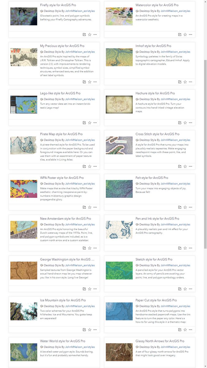
hey, fun news, ArcGIS Pro styles are now available in @LivingAtlas. here is a pile that i've added, if you want to get weird: livingatlas.arcgis.com/en/browse/?q=%…

Graphical Cartograms in ArcGIS Pro - an @Esri blog by me sharing a new tool to create Dorling and Demers cartograms from geographical maps. esri.com/arcgis-blog/pr…


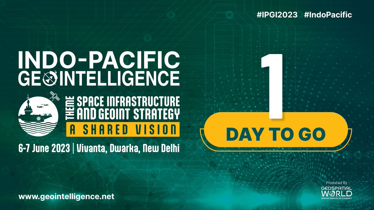
#IPGI #Indopacific #geospatial #defence We are all set to welcome you to the Indo Pacific GeoIntelligence Conference! With just one day remaining, the excitement is palpable as we gear up for this exceptional event. Register now and secure your spot 👉 lnkd.in/dH77kmxK
Trinka AI for academic writing.#AcademicTwitter #AcWri #GetYourManuscriptOut #AmWriting #AmReading #AmEditing
Trinka AI for academic writing.#AcademicTwitter #AcWri #GetYourManuscriptOut #AmWriting #AmReading #AmEditing

Important learnings to become a geospatial data scientist. #gischat #DataScience #DataAnalytics #geospatial #ai #ml

Important learnings to become a geospatial data scientist. #gischat #DataScience #DataAnalytics #geospatial #ai #ml

Discover the #deeplearning capability of #ArcGIS. Use our free learning plan → esri.social/lbGe50OqJmm


"🌍 Calling all Earth & Environmental Science enthusiasts! 🌱 Check out these top 5 machine learning courses to enhance your data analysis skills and advance research in your field. 📚🔬 Unleash the power of AI in understanding our planet. #MachineLearning #EarthScience
Join the upcoming webinar by @Esri_Health Discover the power of #GIS in #EnvironmentalHealth Monitoring. Explore the #GeographicApproach Register now: ow.ly/fnRI104HnXT #healthGIS #esri #arcgis #mapping #TheScienceOfWhere #GISchat #geospatial @EsriSLGov @ArcGISanalysis
Truly, Geography is one of the most essential subjects of this time. Nowadays, It's crucial for success. Let's give it the appreciation and attention it deserves. #Education #SuccessSkills #Geography #GIS

Interested in making amazing maps? Join Esri's Cartography MOOC.

Kuldeep Yadav @Kuldeep33923017
1 Followers 20 Following
Mushahid Nabi @Mushahidnabi111
151 Followers 335 Following Bs Disaster Management | GIS analytics | NEBOSH | HSE| Safety Officer |
Abdulmalik musa @Abdulmalikk001
12 Followers 91 Following Geographer: Goal Oriented, following a line of conduct as through it were a professional with a untouchable educational background in Geography , GIS/RS.

Yannisli.Tzimas @noey89bxlj
6 Followers 183 Following jollibee777 chess and card game, nakatutok sa Philippine market, register now at makakuha ng P88 ng libre
Geozeerah GIS & Spati... @MusaMuhali
1K Followers 3K Following GIS and Remote Sensing Expert | UAV Pilot | Plantation establishment specialist.
Map Lab 🌎 @MxMapLab
69 Followers 471 Following PhD Socio-Territorial Studies / GIS Expert #UrbanPlanner #PlaneadorUrbano #GIS #SIG
University of Jos You... @UJ_YouthMappers
259 Followers 336 Following Passionate group of students from University of Jos dedicated and contributing to humanitarian development through open mapping. || Youth Chapter @YouthMappers
GeoDAJ Consultants @GeoDAJ_Ltd
1K Followers 1K Following GIS|| Remote Sensing|| Land Surveying|| Cartography|| Web Mapping|| Environmental Impact Assessment|| Building and Construction||
Carrie Adair @carrieis
564 Followers 2K Following GIS Geek • Cartographer • Wife• Mom • Caregiver • Genealogist • Vipassana Meditator • Hiker • working in the post wildfire landscape.
Crowd2Map Tanzania @Crowd2Map
4K Followers 3K Following Crowdsourced #mapping rural #Tanzania into OpenStreetMap for better navigation, progress towards the #SDGs to help #EndFGM. Join us & become part of the Crowd!
Geoscience Mapping So... @GMS_Mapping
3K Followers 3K Following GIS|Remote Sensing|Cartography|Survey|GIS Programming|Geodatabases Management|Data Science|YouTube Tutorials|Online and Physical Training
🇧🇿 Belize GEO �... @BzGEO
10K Followers 7K Following Belize GEO: Belize Group on #EarthObservation & GIS. #SciComm re: EO, GIS relevant to #Belize, the #Caribbean. Administered by a real live Belizean scientist.
Sambit Behera @sam_bitbehera
26 Followers 166 Following Data Analyst at @terraqua_uav | ex-IITKian | Geoscientists | Remote sensing | GIS Photographer |
Shobhits @FluvialShobhit
398 Followers 2K Following Research Scholar @ IIT Kanpur | Fluvial geomorphology | Exploring Geospatial, drone tech, ML in River science research | J🌍💡
TerrAqua UAV @terraqua_uav
32 Followers 69 Following Founded by the Researchers of IIT Kanpur , TerrAqua is Empowering Sustainability with High-Resolution Data and Geospatial Intelligence
R Markdown @rmarkdown
29K Followers 431 Following A community of R Markdown enthusiasts posting anything related to #RStats, especially #RMarkdown, #QuartoPub and #Bookdown.
OpenStreetMap India @osm_in
2K Followers 793 Following Official Twitter/X of the OpenStreetMap India Community. Telegram: https://t.co/pNrJorRMnt Maps: https://t.co/0xeLCrKi3I https://t.co/pyOiJEsbhh
G-DEV🌎🖥 @GeospatialDev_
1K Followers 665 Following We are a group of @DeKUTKenya Geospatial students doing Software Education|Data Analysis|GIS Programming|Surveying|RemoteSensing|[email protected]
Erwan Rivault @ErwanRivault
2K Followers 1K Following Data visualisation designer @BBCNews | previously @ESA_EO
Sarah Bell @sarahbellmaps
11K Followers 1 Following cartographer • data visualization scientist • rock climber
IMAGIN @michigangis
215 Followers 219 Following IMAGIN is a professional development non-profit for Geographic Information System (GIS) users in the Great Lakes State. Let's get #MappyMichigan! 🌲🧭🦌🌐🌊
Geozeerah GIS & Spati... @MusaMuhali
1K Followers 3K Following GIS and Remote Sensing Expert | UAV Pilot | Plantation establishment specialist.
Robin Cole @robmarkcole
11K Followers 4K Following Tackling the worlds toughest challenges with AI & ML applied to satellite & aerial imagery https://t.co/QmbOWgdfAZ
Remote Sensing MDPI @RemoteSens_MDPI
21K Followers 901 Following No. 1 #remotesensing #openaccess journal in Remote Sensing Category in #WoS, published by @MDPIOpenAccess; IF 2024 4.1; CiteScore 2024 8.6; #mdpiremotesensing
Map Lab 🌎 @MxMapLab
69 Followers 471 Following PhD Socio-Territorial Studies / GIS Expert #UrbanPlanner #PlaneadorUrbano #GIS #SIG
GeoDAJ Consultants @GeoDAJ_Ltd
1K Followers 1K Following GIS|| Remote Sensing|| Land Surveying|| Cartography|| Web Mapping|| Environmental Impact Assessment|| Building and Construction||
Open Geospatial: OGC @opengeospatial
27K Followers 230 Following OGC’s member-community of experts makes location data Findable, Accessible Interoperable, and Reusable (FAIR) through #innovation #collaboration and #standards
Wanmei L 🌎🛰️ @MapsbyW
3K Followers 269 Following Science Data Visualizer at NASA 🌎 🛰️ 🗺️ | UCLA Alumni 🎓 | Visual Storyteller 📚 | Cartographer 🧭
Matt Malone @MatthewHMalone
9K Followers 568 Following GIS Professional/GIS meme aficionado | Geography, geology and weather geek | 🐘 https://t.co/tZmoBPjeig 🦋https://t.co/7nMrtkx5sH
Ujaval Gandhi @spatialthoughts
17K Followers 436 Following Educator | Founder @ Spatial Thoughts | Helping people learn and master geospatial tech - #QGIS, #Python, #GDAL, #EarthEngine | Ex-Google
🥔🗺️ ᴘᴏᴋ... @pokateo_maps
28K Followers 3K Following po-KATE-o, first of her name, eater of potatoes 🥔 and maker of maps 🗺️. I make GIS (more) fun by sharing maptastic themes & original mappy memes! 🌐 ᵛᶦᵉʷˢᵐᶦⁿᵉ
atlo.team @AtloTeam
1K Followers 826 Following Visual and data journalism team of Budapest-based investigative center @Atlatszo #dataviz #datavisualization #graphics #ddj #maps #datajournalism
Sentinel Hub @sentinel_hub
37K Followers 443 Following A geospatial developer platform for EO data, part of @Planet. We are moving our social to @Planet. Follow us there!
Copernicus EU @CopernicusEU
135K Followers 2K Following The Earth Observation component of the EU Space Programme
attilabatorfy.bsky.so... @attilabatorfy
3K Followers 2K Following master teacher of journalism and information graphics @eltebtkmmi, head @atloteam, https://t.co/fWcwGGxb4a / https://t.co/RJU1vyLm6j
Sérgio OSMsmaprs @sergioajv1
4K Followers 903 Following Architect, worldwatcher, geogeek 🇧🇷 I like maps, images, Nature & Humanity. 🛰️Satellites, 🗺️Maps & 🌐Geospatial - Porto Alegre, Brazil. Views my own
Shobhits @FluvialShobhit
398 Followers 2K Following Research Scholar @ IIT Kanpur | Fluvial geomorphology | Exploring Geospatial, drone tech, ML in River science research | J🌍💡
Geography with Justin @GeoWithJustin
2K Followers 352 Following Systems Analyst • GISP • PhD Student 🌎🌍🌏🛰️🗺️ Research: RS of Urban Climate Dynamics & Resiliency Married 🗣️ DE/EN/ES/FR/IT
GRASS @GRASSGIS
5K Followers 210 Following GRASS news, tutorials, and other resources on geospatial. Also at https://t.co/oVs3uafsUf (@[email protected]) #GRASSGIS #OSGeo
O'Reilly Media @OReillyMedia
105K Followers 20K Following Gain technology and business knowledge and hone skills with learning resources created and curated by O'Reilly experts
TerrAqua UAV @terraqua_uav
32 Followers 69 Following Founded by the Researchers of IIT Kanpur , TerrAqua is Empowering Sustainability with High-Resolution Data and Geospatial Intelligence
gdal org @GdalOrg
4K Followers 6 Following No longer here. Find us at @[email protected] GDAL is a translator library for raster and vector geospatial data formats.
OpenLayers @openlayers
16K Followers 18 Following An open source JavaScript library for creating interactive maps from any kind of geospatial data

The Real GeoServer @GeoserverO
2K Followers 28 Following Proudly brewing geospatial data and maps since 2000. Free and Open Source!
Rabi Shrestha® @frozenrabi
561 Followers 645 Following | Geomatics Engineer-@hello_nea | @HOTOSM @openstreetmap Voting Member| @youthMappers| Talks about 🗺️ & ⚽️🇳🇵
ArcGIS Urban @ArcGISUrban
1K Followers 38 Following ArcGIS Urban is a web-based 3D planning experience that enables communities to make smart decisions for urban development. #UrbanPlanning #3D #SmartCities
ArcGIS Apps @ArcGISApps
17K Followers 268 Following On your desktop, mobile device, or browser, ArcGIS Apps are a collection of integrated, location-based apps that work wherever you do. Brought to you by @Esri.
ArcGIS Survey123 @ArcGISSurvey123
8K Followers 340 Following Smarter forms, smarter decisions! Included with ArcGIS.
ArcGIS StoryMaps @ArcGISStoryMaps
30K Followers 922 Following ArcGIS StoryMaps empowers you to tell stories, collections, and briefings with maps and multimedia. Join our growing global storytelling community.
Mini Map-Makers Globa... @MiniMapMakers
2K Followers 5K Following #MiniMapMakersGlobalCIC #Cartography #Craftography #Maps #STEAMforCartography #notjustcolouringin #geography #Science #Art #Music #GettingChildrenMapping #world
Minds Behind Maps @MindsBehindMaps
2K Followers 1 Following Maps are everywhere; These are conversations with the people building them | Hosted & Produced by @MaxLenormand
Geoscience Mapping So... @GMS_Mapping
3K Followers 3K Following GIS|Remote Sensing|Cartography|Survey|GIS Programming|Geodatabases Management|Data Science|YouTube Tutorials|Online and Physical Training
Geoluminous Co. Ltd |... @geoluminousCo
289 Followers 64 Following Creating gifts, lifestyle products & experiences using maps | 👥CoFounded by @mooresther__ @svelte_Mo |📍Registered in 🇳🇬 & 🇬🇧 | Visit the Mappy Store 🔗⬇️
Spatialnode @spatialnodehq
1K Followers 280 Following Let's be honest, setting up a geospatial portfolio has never been this easier. Create one in a minute or less on Spatialnode. Need help? DM or Tweet at us!
M D Madhusudan @mdmadhusudan
7K Followers 1K Following Average naturalist. Hesitant ecologist. Confused conservationist. Weary of experts. Loves play-doh. And maps. Wants to write better code.
Thejesh GN ⏚ ತೇ... @thej
7K Followers 4K Following Hacker, Maker, Blogger, Developer, Teacher, Public Interest Technologist @datameet & CTO @pepposays hi @ https://t.co/r21wWCpIUm Everything is Personal.
datameet @datameet
2K Followers 150 Following Datameet is a community of Data Science enthusiasts. Tweets by @thej and @fakenisha .
UNIGIS Salzburg @unigis
1K Followers 230 Following Online #Geoinformatics study programs for #geospatial professionals. With 3000+ students and alumni worldwide, we make lifelong-learning happen.
UN Mappers @UN_Mappers
4K Followers 254 Following UN Mappers is a community of mappers supporting UN field activities with open data. UN Mappers is part of the UN Maps initiative. 🇺🇳 Become a #UNMapper!
Mary Muthee @_marymuthee
2K Followers 316 Following It's all about Spatiality😃...In my mappy era💃... Tweeting: #gis #geospatial #programming #RemoteSensing #maps
Esri @Esri
190K Followers 66K Following Esri builds #ArcGIS, the leading location intelligence and spatial analytics software for mapping, 3D GIS, imagery, and geospatial app development.
wes jones @wesleytjones
1K Followers 288 Following https://t.co/DdioqLbjSw (Fantasy Maps) https://t.co/0TqW2HIPDz (Youtube) https://t.co/OdDLSflplW (Map Blog) https://t.co/bzGCRdUZjC (Everything Else) https://t.co/AefMsi70JK (Comic)
Nathan Shephard @NathanCShephard
3K Followers 150 Following 3D mapping, novel writing, cartooning @NeverDidCartoon, parenting, hirsute son of an Aussie farmer.Trends for United States
You might like