
Here is a thread of my favourite maps of Africa. Let me know which you like most and give me your best theories for how thel all fit together. Starting with population. 1/10


@PythonMaps Thrilled to see our Kontur Population data sparking such conversation. 🌍 Just a tiny nudge - it’s Kontur, not Kontour. 😉 Looking forward to more map magic together! 🚀

@PythonMaps Beautiful! Love the evapotranspiration one ❤️

@PythonMaps Your thread is going viral! #TopUnroll threadreaderapp.com/thread/1776625… 🙏🏼@Velowit for 🥇unroll

With all the challenges these maps highlight for the Horn of Africa, Somalia's primary concern appears to be not lack of human impact or climate change but Somaliland. By the way, the majority of maps adhere to a standard that aims to reflect the reality on the ground accurately. Not fictional claims of sovereignty. For those expressing skepticism, refer to the following resource for more info about this standard: naturalearthdata.com/downloads/10m-…

@PythonMaps I had no idea Madagascar is that inhabited

@PythonMaps The 55th country in Africa, the Republic of Somaliland., thank you @PythonMaps ❤️

@PythonMaps Beautiful work of leveraging tech to elevate Africa storylines. Any chance of getting the African roads lines more pixelated (color)?


@PythonMaps Given this data is in python, can you create correlations of each parameter to determine how strongly each is related?

@PythonMaps @alykhansatchu Love these. Bookmarked

@PythonMaps If there's one continent on fire it's Europe and America


@PythonMaps Topography would help explain a lot too

@PythonMaps So the subtropics and tropic cancer regions are less dense.

@PythonMaps Where's IQ distribution? 🤔 Perhaps the most important.

@PythonMaps Don’t forget the map of Chad, Africa


@PythonMaps Empty parts are because of deserts


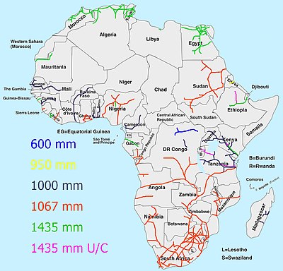
@PythonMaps @rebel_afrika + Different railway gauges in Africa - mostly carved by the various imperialist colonialists to extract resources for their own profits, hampering African railway integration to this day.
@PythonMaps A different perspective


@PythonMaps What about the Electricity in Africa? Did you have a map ?


@PythonMaps Interestingly, Somalia apparently has many roads on the maps, however, a low population. Why then do they have so many roads? Are they really used?

@PythonMaps Aren’t most of these just population maps in disguise?

@PythonMaps The most fascinating is Somali road coverage. How?