Search results for #ONStorm

This weekend will feel like early summer across southern Ontario as 2024's warmest air arrives alongside a risk for thunderstorms. #ONStorm ow.ly/VAvT50RoA1c


The webmaster is getting ready to prepare a delicious supper shortly. @danlee863 #ซินเทจ #lili JG @jfa_nadeshiko #VIVANT 2:3O PM @GlobalDurham #webmaster @TheNoorIbrahim #onstorm Details below👇 @globalnews #TacoTuesday #Mexico #bbcqt #bbmzansi

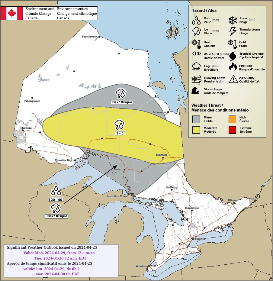
Special Weather Statements have been issued for parts of northern Ontario! 🌧️ A low pressure system will bring rainfall amounts up to 40mm 💧 Details 👉 ow.ly/9BY650RoxwA #ONStorm #ONwx ow.ly/wpUa50Roxwz


#onstorm 5:50p SPECIAL WEATHER STATEMENT ISSUED by Environment Canada Kapuskasing - Hearst Timmins - Cochrane Greater Sudbury And Vicinity Chapleau - Gogama Kirkland Lake - Temiskaming Shores - Temagami Elliot Lake - Ranger Lake Manitoulin - Blind... instantweather.ca/2024/04/25/Cll…
#onstorm 5:46p SPECIAL WEATHER STATEMENT ISSUED by Environment Canada Geraldton - Longlac - Caramat Manitouwadge - Hornepayne Marathon - Schreiber Wawa - White River - Pukaskwa Sault Ste. Marie - Superior East instantweather.ca/2024/04/25/WW5…


Tomorrow. @TheNCCourage #VIVANT 2:3O PM @danlee863 #サッカー日本代表 @juventusfcen #ForTheLove Sunglasses @TheNoorIbrahim #onstorm Details below👇 @TimHortons #ซินเทจ #TikTok #BBCAN12 #bbmzansi

#onstorm 5:02p SPECIAL WEATHER STATEMENT ISSUED by Environment Canada Fort Severn Peawanuck instantweather.ca/2024/04/25/Abk…
A low pressure system will bring rain over parts of northern Ontario Saturday morning into Sunday afternoon 🌧️ Below is a map of the rainfall accumulation forecast for the event 💧 Follow your local forecast 👉ow.ly/T9Zo50RopJu #ONStorm #ONwx


Beautiful day! #onstorm #OnWx #KWAwesome #WxTwitter #ShareYourWeather #WxX

The #webmaster plans to prepare a delicious lunch w/in 118 minutes. @danlee863 #lili #BBCAN12 1:5O PM @TheNCCourage #ForTheLove @YouTube #YouTube #VIVANT @GlobalNational #onstorm Learn more👇 @HondaCanada #Canada @thekccurrent #bbmzansi


Is there a Canadian version of Skywarn Spotters. If so how can you become certified. #onstorm #onwx #canwx. Also @ECCCWeatherON do you do training classes like the NWS? I googled something and it took me to Canwarn but the site it took me to was hard to navigate on mobile.

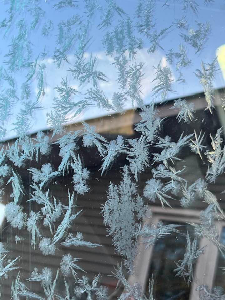
Morning Frost in North Bay this morning, kinda looks like flowers 🌸 📸 - My friend #onstorm #ShareYourWeather #NorthBay #Ont


OntarioStormChasing @ONStormChasing
765 Followers 59 Following CANWARN trained storm spotter. Photographer. IT guy.
ON Storm Updates @ONStormUpdates
100 Followers 29 Following Updates surrounding the GTA and southern Ontario. Lightning radar hosted by https://t.co/FrraEFsbd0.
Greg Greene @ONStormChaser
399 Followers 170 Following Central Ontario storm chaser. and christmas light extraordinaire. Photos and video not to be used/broadcasted without written permission.
WxWitch (Kat McComb) @ONStormKat
261 Followers 283 Following SWON storm chaser. Tweets are my own. 🏳️🌈 friendly. Love, peace and chicken grease. https://t.co/1BuRbN4fej [email protected]
Paulo Santos @ONSTORM4444
1 Followers 4 Following
EC_ONweather @EC_ONweather
943 Followers 85 Following Ontario Storm Prediction Centre | Environment and Climate Change Canada. We do not normally respond. Report weather to #onstorm.
The Perfect Storm �.. @hailpdr
2K Followers 1K Following #Canadian 🇨🇦#stormchaser 🇨🇦 #chasing #storms full time since 2008 Expert On #hail #hailstorms #abstorm #skstorm #onstorm #bcstorm #wxtwitter #spotternetwork
STORM WATCH- Lake Eri.. @StormsOnErie
5K Followers 2K Following Monitoring the infamous Lake Erie microclimate. NWS Skywarn. #ONstorm #OnWx
Scott Rock @scottrockphoto
3K Followers 2K Following Ten years chasing northern lights on Bruce Peninsula, Ontario #northernlights #stormchaser #onstorm #onwx, SWE, @SevereStudios dev, Prints & licensing avail.

Frank Jiang @A3onstorm
9 Followers 0 Following
İsmail Mantar @onstorm2005
5 Followers 0 Following