Search results for #SDwx

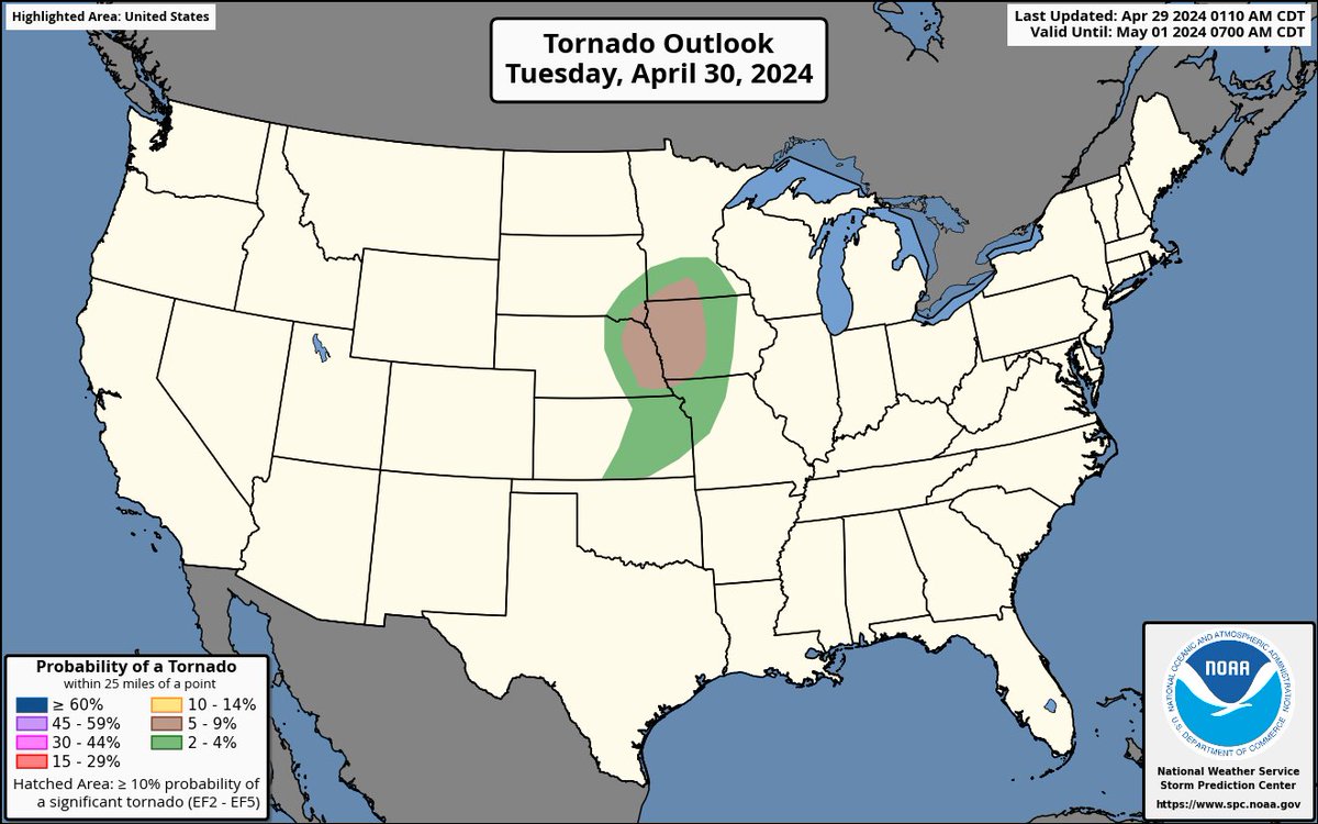
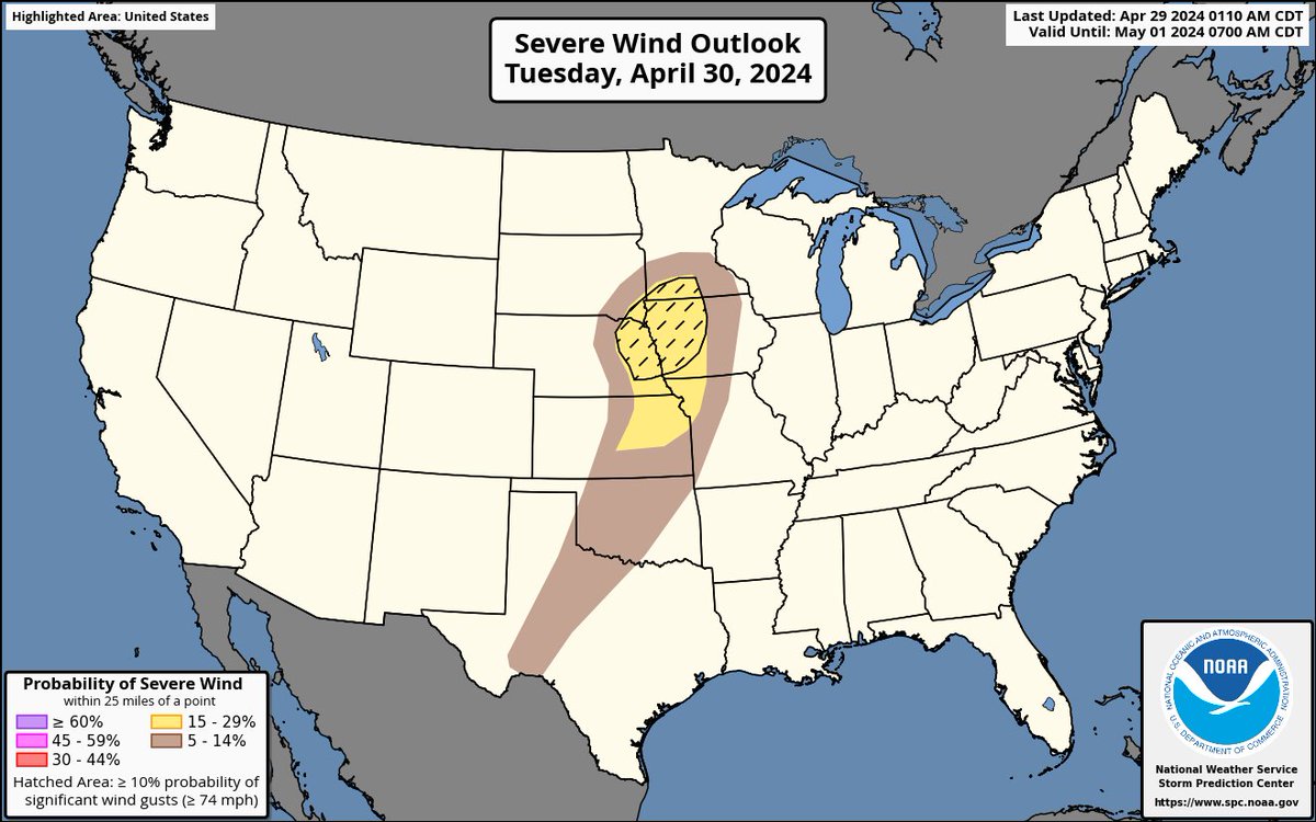
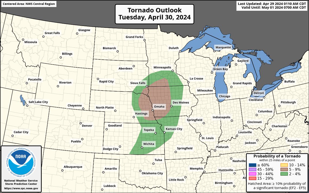
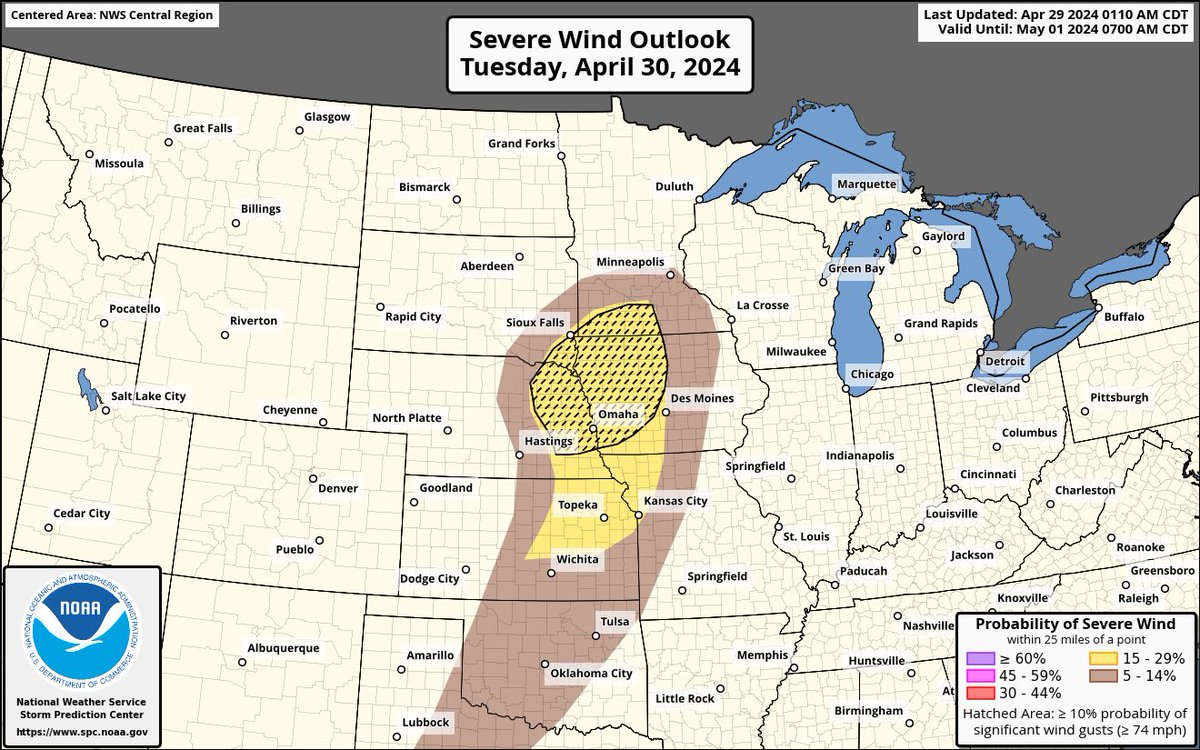
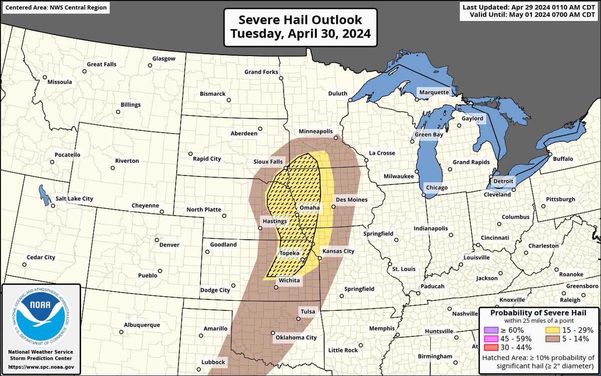
The threat of severe weather will return again this week beginning tomorrow (4/30). Slight risks of severe weather have been posted by the #SPC for day 2 and day 3 including portions of the Southern and Central Plains. #KSwx #NEwx #MOwx #IAwx #SDwx #MNwx #OKwx #TXwx


Dear #Wxtwitter, do u think D2 #SPC showing a #SlightRisk in N #TornadoAlley incl #Omaha,#LincolnNE,#DesMoines,#CouncilBluffs,#SIouxCity,#SiouxFalls,#KansasCity,#Topeka,#Wichita could go #EnhancedRisk on D1? #Wxx #Tornado #hail #wind #KCwx #KSwx #NEwx #MOwx #IAwx #SDwx #MNwx


Despite it nearly being May, we have been getting snow along the US-83 corridor in north central SD this morning. Here's a view from the SDDOT camera on US-83 near Herreid at 746am CDT 4/29/2024. #SDwx


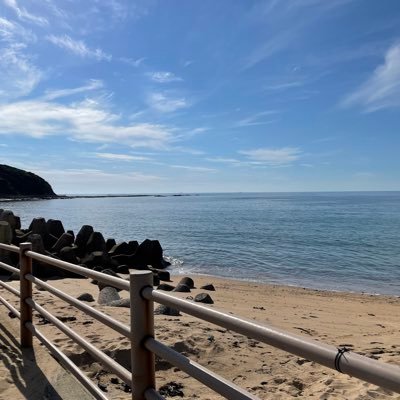
WHAT YOU NEED TO KNOW: * Temps Near Average - Mild Week On Tap * Marine Layer Confined To Beaches Each Morning * Gradual Warm-Up Second Half Of The Week/Into The Weekend #10newsweather #sdwx @10News @10NewsPaz @10NewsAarons

Warm Start To Monday! We are already seeing 50s along the coast & in the deserts to kick off a brand new work week. #10newsweather #sdwx @10News @10NewsPaz @10NewsAarons

MONDAY FORECAST: Patchy AM Clouds; Increasingly Sunshine By Mid-Morning. Look for 70s Coastal, Mountains & Inland Valleys/90s Deserts @10NewsPaz has your Monday Morning Weather on @10News This Morning #10newsweather #sdwx Full Forecast: 10news.com/weather @10NewsAarons


Rain report from Oahe Acres/Grey Goose 0.56” total of 1.90” #SDwx @DrgPierreSD @kccrpierre @NWSAberdeen @richshangreaux @DtwanMeyer @DakotaNewsNowWx @SDSUclimate @kelostormcenter @shawncable @Aaron_Doodah @dustinc55

Rain departs today with partial clearing. A quick moving system crosses the forecast area tomorrow, with showers and non-severe thunderstorms #SDWX


asdfe @sdwx
2 Followers 0 Following
#sdwx Social @sdwxSocial
157 Followers 50 Following User reported, user contributed. Send South Dakota Weather reports using #sdwx! Follow @sdwxSocial to keep up with current SD weather! Part of @SocialWeatherUS.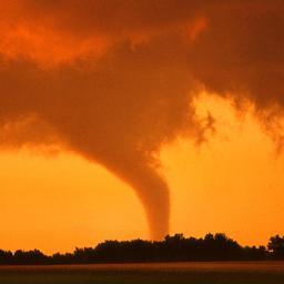


Daewon @XxXxSDWxXxX
6 Followers 1 Following![[2015.06.27~]달콤하게 때로는 흉폭하게(w.김철수) / 손동운(28) 초콜릿가게 사장/ 기광이형이 우주인 순정남 / 팬: 달콤 / 기광이 형옆 항시 대기](https://pbs.twimg.com/profile_images/669869992351956992/KwA5MTxz.jpg)
손동운(28)_X @Sweety_SDWX
34 Followers 10 Following [2015.06.27~]달콤하게 때로는 흉폭하게(w.김철수) / 손동운(28) 초콜릿가게 사장/ 기광이형이 우주인 순정남 / 팬: 달콤 / 기광이 형옆 항시 대기

user_sdwx5577 @user_sdwx5577
167 Followers 2K Following

shai @sdwx_
549 Followers 278 Following
فهد @2AKmjBghp8fSDwx
33 Followers 148 Following

-_- @SDWX91
7 Followers 5 Following
Maria_022 @AX7sOuvSDWX7eQW
43 Followers 86 Following Hi!I'm directioner and i think,that Larry is REAL!!!
أحباب الروح @sdwxMKm3Weo0AyX
33 Followers 80 Following
پہہوپہہوو @SDwx6176ksNJGoQ
12 Followers 96 Following " ثُم أن يدّي لا تُلوى ، وقلبي لا يُهان ، وأنا لا أسقُط "💜

. @sdwx2201
2 Followers 2 Following
矢羽田しょーは.. @SDwxAfFPeV42931
0 Followers 1 Following
❣Mnjeya❣ @SDWx7WyBhqJYXIa
9 Followers 30 Following


بنت الجنوب @7SDwxCy1lUEBp4d
8 Followers 60 Following ع حب الزمالك تجمعنا الخاص ممنوع اي تجاوزات بلوك

SDWx @SDWx11
11 Followers 95 Following
gg @sdwx1028
71 Followers 816 Following
ماقدر انساك @ySdwxUVC4B0HytP
3 Followers 3 Following
Sebastián Salazar @sdwx2
25 Followers 0 Following
sdwx_gih @GIO_FER_SIQ
2 Followers 4 Following
Rae Pewitt @Raeoy6sdwx23u
4 Followers 0 Following Passionate travel enthusiast. Prone to fits of apathy. Certified introvert. Friendly entrepreneur. Writer
Samantha Weston @sdwx3
6 Followers 0 Following
SDWX187 @sdwx187
3 Followers 13 Following
Наталья @xY68sdwxUb4AvfO
4 Followers 23 Following
عزيز علو @KduSDwx370o8rMm
24 Followers 177 Following
खुशमन म�.. @CUQqSuqCqG5Sdwx
12 Followers 68 Following
つ@英語勉強中 @x1wg5vY12SDwxW0
5 Followers 15 Following


向日葵 @o9PHHtSDWxSYC5O
0 Followers 24 Following

أبو مشعل غن�.. @erMF6Sdwx6rgjeN
2 Followers 19 Following

SheilaNick @y7819YYP5SDwxJ
10 Followers 2K Following
SdwX @mister_sandy
19 Followers 246 Following

سالم123 @sdwx124
3 Followers 7 Following


ابو المهند �.. @wif13oSDWxXLzN7
2 Followers 0 Following
蜂谷久美子 @uyBhegyrSdwxMUh
1 Followers 3 Following
511 @sdwx5ll
1 Followers 8 Following
9455424151 @64IbSDwx6hqcwat
1 Followers 63 Following


Ирина Шуст @NkR0l1sdwxFMAMH
1 Followers 5 Following

佐野義尚 @sSDWx1fnCEi1sAf
0 Followers 6 Following
بشاير العجم.. @sdwxOeyiGzRFzVZ
6 Followers 183 Following
عبدالفتاح ا.. @BudJlY0SdwxDnGA
0 Followers 0 Following

pou!!( ゚∀.. @ysa1tSdwxKDUlXN
12 Followers 81 Following すとぷりすなーでございます(●︎´▽︎`●︎) 箱推しです…I˙꒳˙) 歌い手さん、ゲーム実況さんはほとんど好きです!下ネタを愛してまs(((

Lennn Sdwx @Sw_Xianho
0 Followers 15 Following
Swx Sdwx @SdwxSwx53213
0 Followers 1 Following

島田哲也 @SDwx12dqw0GjiYY
0 Followers 0 Following
chdnbgljgh @ort977sdwx
0 Followers 0 Following
猫黒 @4SdwxZYNUZjWXtG
1 Followers 8 Following

катя @sdwxK0aigv
3 Followers 32 Following
אשר עבאדי @QVRfHzriSDWX9sC
3 Followers 0 Following

sdwx dwsqa @SdwxD63364
0 Followers 0 Following
Евгений @ySsvU3TW4uSDWx9
0 Followers 0 Following
サッカー @xf0qa2SDWx60838
1 Followers 1 Following
Melinda Monguzzi @vvyxz2sdwx
0 Followers 1 Following


หน่วยซิ.. @sX84wY5gLpqSDWX
0 Followers 5 Following

昭史 @lvPgLZQMKqoSDwx
0 Followers 0 Following
Sila Meslin @sdwx_1
0 Followers 23 Following

วรรณิศา @tFbXP2RVPThSdwx
0 Followers 38 Following


みP @SDWX6hfOOq81464
0 Followers 1 Following
Gabriel&Steven Callej.. @SDWxPsychoxX
0 Followers 2 Following
บอย 2020 @SdwxZ607jyLXNB6
0 Followers 7 Following
EricaKeynes @53Sdwx60V6J4yJq
0 Followers 3 Following If it doesn't fit, don't put it on. If you do, you will only disgust yourself and delay others.

jghg @Pod5X2HxSdwxEju
0 Followers 0 Following
v2045653l8 s5384w3zn @s11sdwx7r215
1 Followers 0 Following