Search results for #MOwx

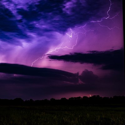
Scattered showers and thunderstorms look to continue across the Mid-South through around midnight. Severe potential remains low, though occasional lightning and gusty winds will remain possible as a cold front pushes precipitation west to east. ☔️ #mowx #arwx #tnwx #mswx


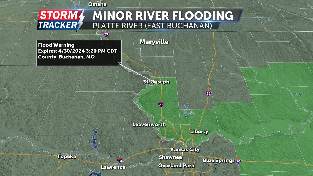
Tracking another threat for scattered strong to severe storms across Northwest MO and Northeast KS late Tuesday afternoon and evening. Primary Hazards: Damaging winds, hail, isolated tornadoes. Rainfall could also exacerbate minor river flooding. #mowx


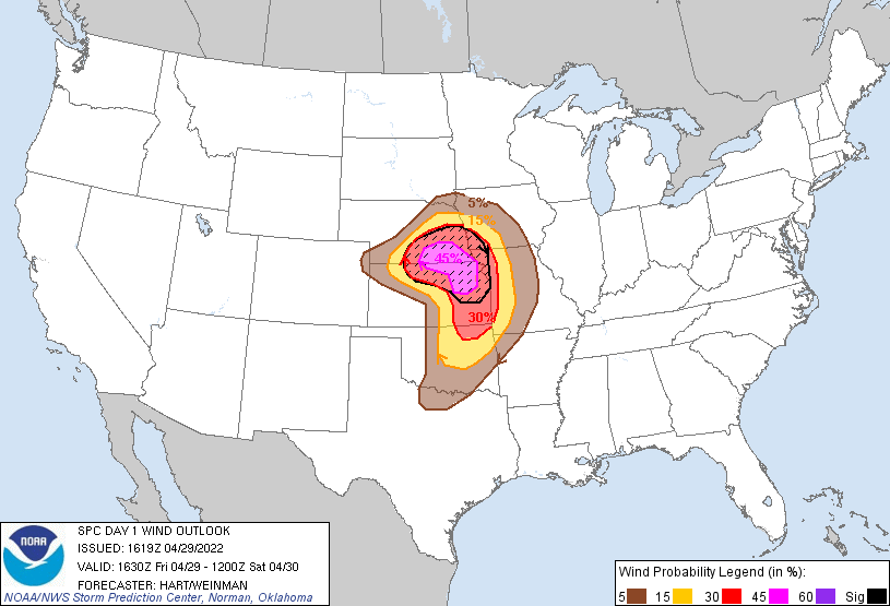
Dear #Wxtwitter, do u think D2 #SPC showing a #SlightRisk in N #TornadoAlley incl #Omaha,#LincolnNE,#DesMoines,#CouncilBluffs,#SIouxCity,#SiouxFalls,#KansasCity,#Topeka,#Wichita could go #EnhancedRisk on D1? #Wxx #Tornado #hail #wind #KCwx #KSwx #NEwx #MOwx #IAwx #SDwx #MNwx
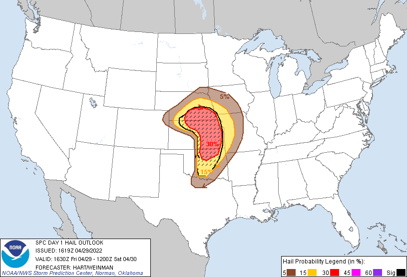
29/4/22 #ModerateRisk in SE #Nebraska, NE #Kansas, NW #Missouri states of #TornadoAlley esp #Topeka, #ManhattanKS, #JunctionCity, #BeatriceNE, #LincolnNE, #HastingsNE cities due to 15% SIG #Tornado, 45% SIG #Wind and 30% SIG #Hail Risks #Wxtwitter #SPC #SevereWX #NEwx #KSwx #MOwx


FirstWARN Alert: Flood Warning for St. Louis and St. Louis City in MO. From Meteorologist Nick Palisch #mowx
FirstWARN Alert: Flood Warning for Perry and Ste. Genevieve County in MO. From Meteorologist Nick Palisch #mowx
FirstWARN Alert: Flood Warning for Jefferson County in MO. From Meteorologist Nick Palisch #mowx
FirstWARN Alert: Flood Warning for St. Charles County in MO. From Meteorologist Nick Palisch #mowx
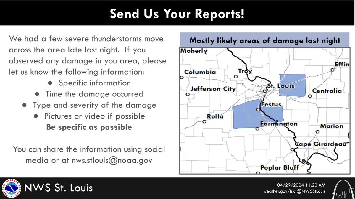
A few severe thunderstorms moved through parts of the area late last night. If you had any damage, please share here or send email us at [email protected] #mowx #ilwx #stlwx


#mowx Social @mowxSocial
136 Followers 50 Following User reported, user contributed. Send Missouri weather reports using #mowx! Follow @mowxSocial to keep up with current MO weather! Part of @SocialWeatherUS.
夜梦 @mowxP9U13X15981
7 Followers 9 Following

Nick Bender @NickBenderKMBC
20K Followers 2K Following Morning Meteorologist & Storm Chaser at @KMBC in Kansas City. I call the Plains Home. Christian. Husband. Father. Penn Stater. Angler. #MOwx #KSwx
T Eckhoff KB0UVT @Mowx1
67 Followers 191 Following coop weather observer Ham Electronics Weather Geology rock tumbling


Missouri Weather Watc.. @MOWX_Watch
35 Followers 42 Following Weather, photography, and nature enthusiasts.

1234 56 @MowxCbyxcEvWTxU
10 Followers 6 Following
Xuân Thy @ThyMowx
71 Followers 152 Following

Myx_Mowx @Khoai_
76 Followers 146 Following

Jessica Hafner @JessicaABC17
5K Followers 2K Following Chief Meteorologist at @ABC17News. @ametsoc CBM. Wife, mom 👶🏻🐶, runner🏃🏻♀️, and proud @NIUlive alum🐺. #CoMO #JCMO #LOTO #mowx #midmowx

Mowx @kheldory199
89 Followers 361 Following

ابوبدر @MsHjGFrMOwx9IFl
4 Followers 5 Following
ちこ @hwUwnMOwxBivxg1
23 Followers 31 Following


桜月姫乄朧月 @w66Jb1VFuSqMOwx
24 Followers 43 Following
mowx @mowx0201
9 Followers 105 Following
Matt Beckwith @KOMUMatt
5K Followers 4K Following Chief Meteorologist @KOMUNews|Mizzou Atmospheric Science Alum|@MizzouMet|Believer in Ethical Weather Communication|Opinions Are My Own |#MidMoWx|#MoWx|☀️🌦🌩🌈


هشام العراق.. @EukFQ4viooyMOWx
31 Followers 82 Following
あみぅっち(・`�.. @XuaMOWx8a270349
6 Followers 34 Following うらーかです。よろしくです。フォロしてくれた人だけね。キラカワ系です^_^ゲームの時に暴言吐く人に犯されたい。けっこうむちむちだけど抱けますか?


Eason @8cmSP4ZL8mowxKW
3 Followers 8 Following
Mad Mowx @MmeMowx
6 Followers 99 Following
6477639360 @f3vMOWxENZ31iH6
4 Followers 9 Following

ÜMwxD(MoX)Ü @MowxD09
4 Followers 30 Following
MOWX_94 @Dieu_EXO12_OSH
20 Followers 186 Following Em yêu thương một thiên thần, một thiên thần rơi từ trên trời xuống mà không bị đau mông - Oh Sehun 😑
CoMOStorm @CoMOwx
4 Followers 10 Following
tuan nguyen @mowx222
3 Followers 13 Following

のぶ @bxKkao3pmMOWx1F
2 Followers 5 Following
. @Mowx140
0 Followers 0 Following
Rabbit @XxGizMowxX
7 Followers 0 Following
oudsu @fPfNhuMOwx6HMhp
1 Followers 5 Following

Khánh Đinh @MowxBorder
4 Followers 63 Following
ام عبدالله �.. @MOWxQq7PftXK6IN
1 Followers 1 Following
Nguyễn Thu Trang @TrangMowx
1 Followers 2 Following
りな @LS03eMOwxIVHZa4
0 Followers 110 Following
mowx @moxmjeekd
5 Followers 47 Following
.وسام الموس�.. @a4MOwxLZnq3GU0o
7 Followers 122 Following
( ˙ ˙ ) @VFhp4vMOwx0N9hF
1 Followers 1 Following
新田真剣佑 @TJGSe24MOwx5Ptk
12 Followers 157 Following

Hải Mỡ @HaiMowx
0 Followers 12 Following


جمان 33 @L0821MowxPIsWUQ
1 Followers 7 Following حياكم في حسابي لموقع حراج اتمنى من اي عميل يمر ع التغريدات يوصل للمعلن وين شاف الاعلان الله يسعدكم دعمكم لي شرف وشكراً للجميع

Елизавета Д.. @Gt7j4RaMOWx24f3
6 Followers 21 Following
ماجده ذكى @eGtqIrrX6pMowxO
4 Followers 17 Following
新井周一 @MOWx81PoEM6Trd4
0 Followers 0 Following
mr.mowx @al3tibi5112
3 Followers 3 Following
岡部雅由 @NjumjBtxw6MOwxM
0 Followers 1 Following
شخصيه محترم.. @bj8lZoC6duMOWx7
1 Followers 12 Following
Linh @nml_mowx
0 Followers 12 Following

jerome dela cruz @mowxD
1 Followers 20 Following

رائف @BwaByCHL6okMowx
0 Followers 0 Following
seham @2te8MOWX065szdS
1 Followers 0 Following
An Mỡ @an_mowx
1 Followers 26 Following

Mowx26 @mowx662006
1 Followers 16 Following
عبد فهد @L9MowxLh6BlegDJ
0 Followers 0 Following
Morgane Pawlowski @MadMowx
1 Followers 0 Following


MOWxVNSRS @MOWxVNSRS
0 Followers 0 Following
mowx @mowx622970
0 Followers 1 Following
أبداعات شبا.. @mowx9
2 Followers 38 Following

p8xf20lcnqxjzb @ib4qjz5mowx
0 Followers 0 Following
محمد سمبو @mMOwxHiNQqVIVRB
2 Followers 41 Following
ابو خالد @mowx506
0 Followers 0 Following
Anh Trương Đức @mowx_2004
0 Followers 0 Following