Search results for #SevereWX
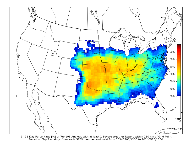
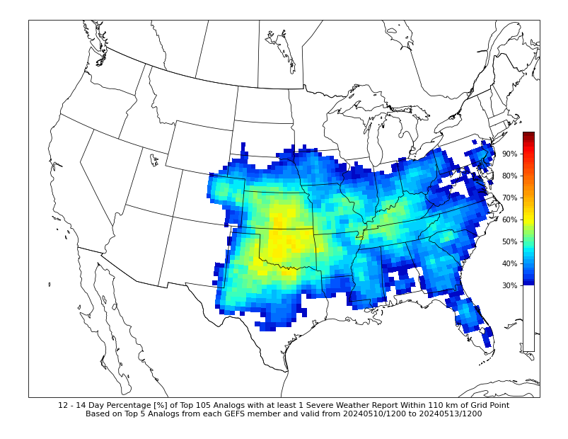
Extended range analogs from @CIPSAnalogs show increasing probabilities of severe weather as we head into the week 2 period! The pattern looks to remain active into May! #USwx #Severewx


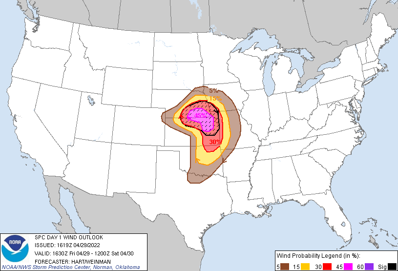
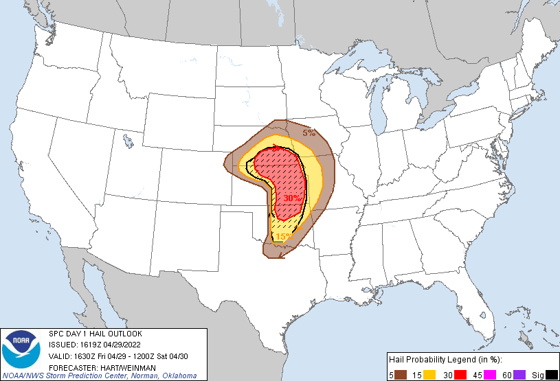
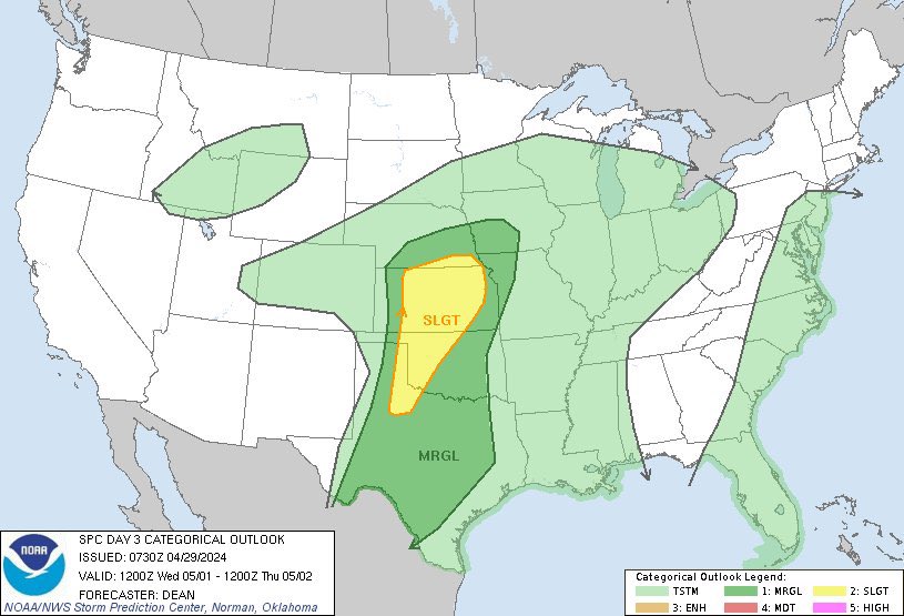
29/4/22 #ModerateRisk in SE #Nebraska, NE #Kansas, NW #Missouri states of #TornadoAlley esp #Topeka, #ManhattanKS, #JunctionCity, #BeatriceNE, #LincolnNE, #HastingsNE cities due to 15% SIG #Tornado, 45% SIG #Wind and 30% SIG #Hail Risks #Wxtwitter #SPC #SevereWX #NEwx #KSwx #MOwx


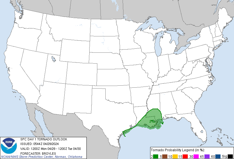
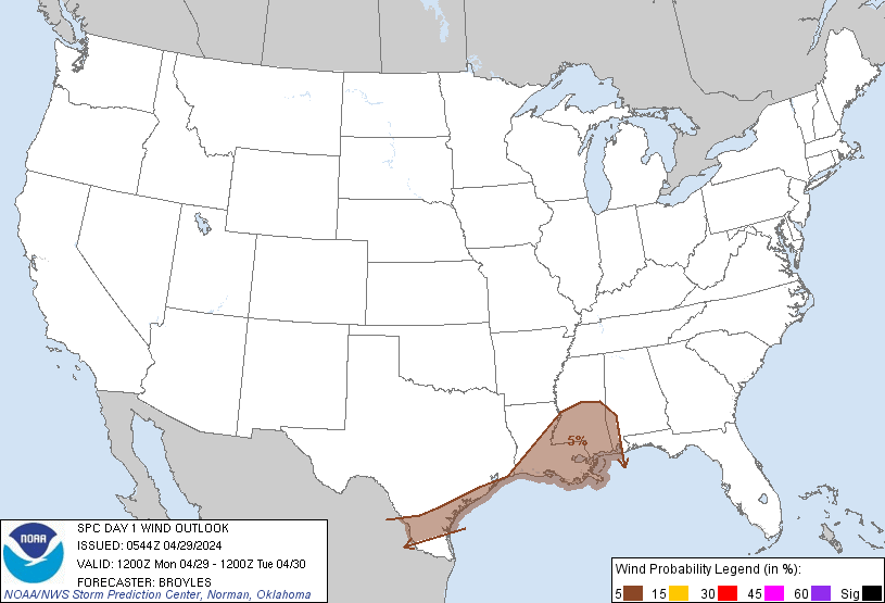
D1 1630z #MarginalRisk in S #Texas,S #DixieAlley,E #Michigan esp #CorpusChristi,#Laredo,#NewOrleans,#Kenner,#metairie,#Detroit,#Mobile,#SterlingHeights,#WarrenMI,#Flint,#AnnArbor 2%#Tornado/5%#Hail/#Wind risks #TXwx #SPC #SevereWX #STXwx #LAwx #MSwx #ALwx #Wxtwitter #Wxx #MIwx

D1 1630z #MarginalRisk in S #Texas,S #DixieAlley,E #Michigan esp #CorpusChristi,#Laredo,#NewOrleans,#Kenner,#metairie,#Detroit,#Mobile,#SterlingHeights,#WarrenMI,#Flint,#AnnArbor 2%#Tornado/5%#Hail/#Wind risks #TXwx #SPC #SevereWX #STXwx #LAwx #MSwx #ALwx #Wxtwitter #Wxx #MIwx https://t.co/VOHrMWxMZA

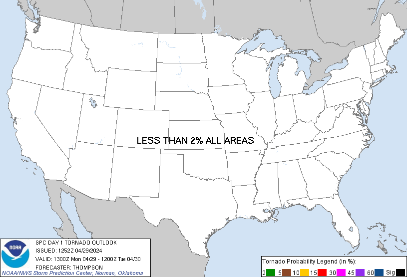
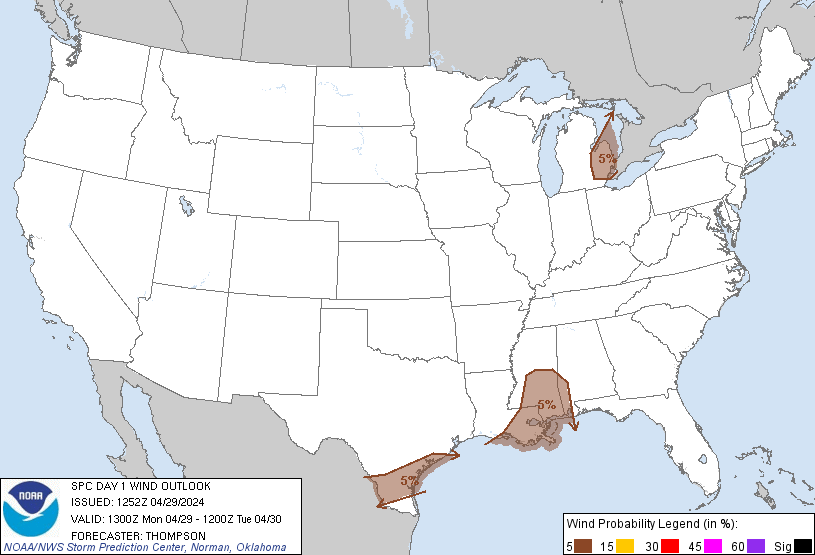

D1 13z #MarginalRisk in S #Texas, S #DixieAlley, E #Michigan esp #Galveston,#CorpusChristi,#Laredo,#NewOrleans,#BatonRouge,#Lafeytte,#LakeCharles,#JacksonMS,#Detroit,#Mobile <2%#Tornado/5%#Hail/#Wind risks #TXwx #SPC #SevereWX #STXwx #LAwx #MSwx #ALwx #Wxtwitter #Wxx #MIwx
D1 13z #MarginalRisk in S #Texas, S #DixieAlley, E #Michigan esp #Galveston,#CorpusChristi,#Laredo,#NewOrleans,#BatonRouge,#Lafeytte,#LakeCharles,#JacksonMS,#Detroit,#Mobile <2%#Tornado/5%#Hail/#Wind risks #TXwx #SPC #SevereWX #STXwx #LAwx #MSwx #ALwx #Wxtwitter #Wxx #MIwx https://t.co/9eAV65cOsi


Moisture return for this week has been downtrending rapidly and has gone from the 70s to mid/upper 60s. That, plus weak flow aloft is my primary uncertainty with this week. We will see how it plays out from here but It doesn't seem too lined up #weather #severewx #wx #twitterwx


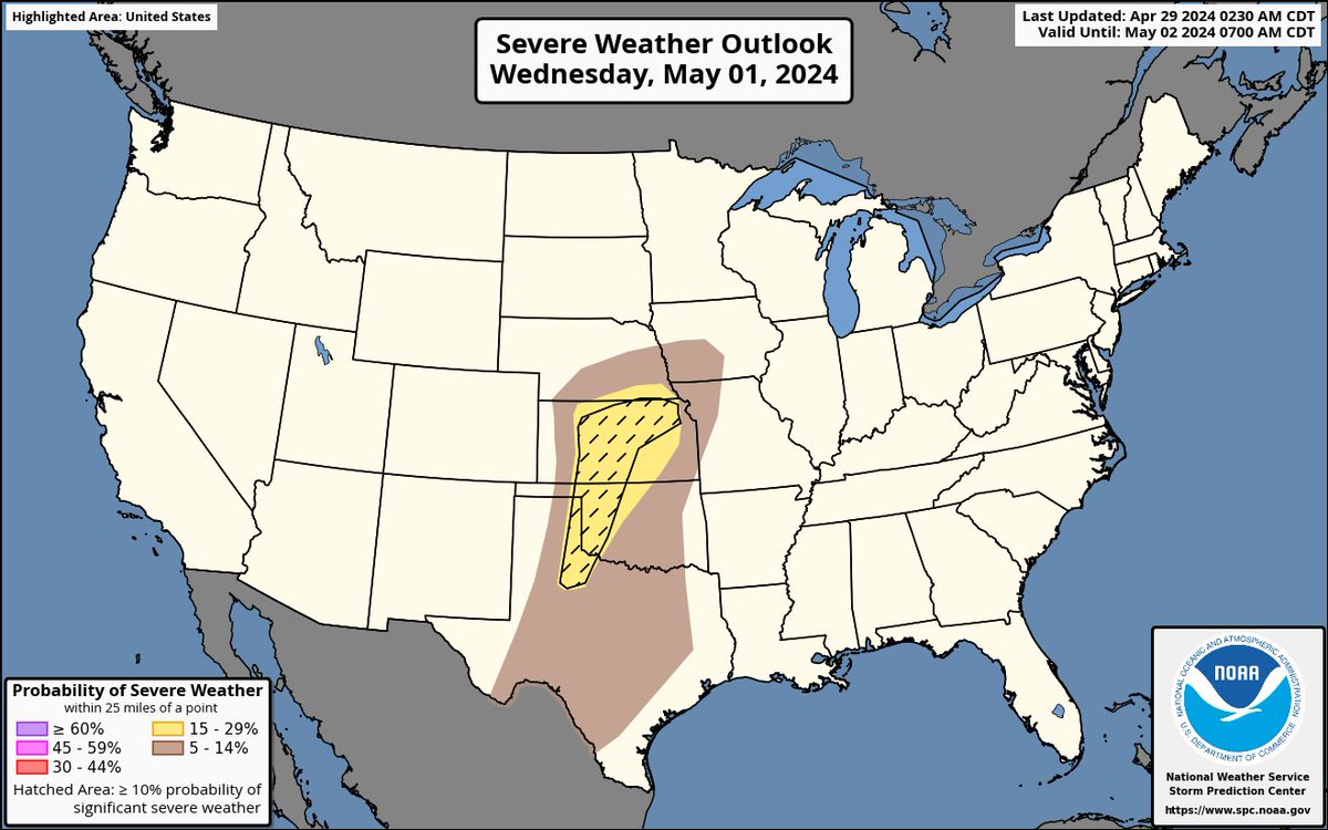
While there may be a brief reprieve today for some recovering from #SevereWeather, please be #WeatherAware as chances return to the same impacted areas starting tomorrow (#Tuesday 4/30) continuing into #Wednesday (5/1). #Tornadoes are possible, some strong on Wed. #SevereWX

Beautiful MCS (Mesocalse Convective System) moving through the deep south states of Texas, Louisiana, and Mississippi. Tons of lighting within this and is non-severe, and should stay that way, but instances of severity can’t be ruled out. #wxtwitter #txwx #lawx #mswx #severewx

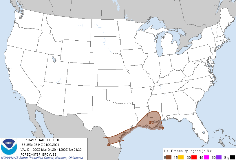
#severewx Monday Valid 291200Z - 301200Z ...THERE IS A MARGINAL RISK OF SEVERE THUNDERSTORMS FROM PARTS OF SOUTH TEXAS INTO THE LOWER MISSISSIPPI VALLEY...


Joseph Wilson @SevereWX
46 Followers 34 Following Bourbon Enthusiast, Storm Watcher, Ham Radio Operator, Photographer
RuthSevereWx @RuthSevereWx
18K Followers 98 Following Our goal: provide real-time, localized severe wx info for Rutherford Co. NWS VERIFIED/CERTIFIED. WRN Ambassador.
WilsonSevereWX @WilsonSevereWX
9K Followers 69 Following NOAA WRN Ambassador & NWS verified/certified. Providing severe weather information for Wilson County Tennessee. NWS Distinguished Service Award Recipient.
NashSevereWx @NashSevereWx
304K Followers 420 Following Community Supported Local Weather, Nashville & Williamson Co ° @NashvilleScene Readers' Poll Best Twitter Acct '14-'23 ° 2016 & 2022 NWA W. J. Bennett Award
TravisCountySevereWx @TravisCOSW
14K Followers 207 Following @NWSSanAntonio Partner • SKYWARN® Spotters • Daily/severe wx info for Austin & Travis County • NOAA Weather-Ready Nation Ambassador™ #ewxspotter #VOST #atxwx
Severe Weather UK @SevereWxUK
4K Followers 9 Following London based team bringing you severe weather info from across the UK!
BexarCountySevereWX @BexarCOSW
7K Followers 46 Following NWS EWX #VOST partner & NOAA Weather-Ready Nation Ambassador™. Along with @NWSSanAntonio, we inform, educate & provide general/urgent weather info. #SATWX

Murfreesboro Weather @MboroSevereWx
11K Followers 60 Following NWS-Nashville #tSpotter Partner. VERIFIED/CERTIFIED Graduate Storm Spotter and WRN Ambassador for Rutherford County. Use #tSpotter to report to the NWS.
SevereWeather2020 @SevereWx2019
7K Followers 2K Following Severe Weather Updates https://t.co/8lbQAStFjd - NMM derivative (resolves to 50mtr resolution) https://t.co/wP5vcjM7tx
Bedford SevereWx @BedfordSevereWx
1K Followers 65 Following NWS-Nashville #tSpotter Partner. VERIFIED/CERTIFIED storm spotter and WRN Ambassador for Bedford county. Use #tSpotter to report to the NWS. Support us on Venmo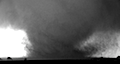
Severe WX Warnings @WarningsFeed
661 Followers 4 Following The top source for severe weather warnings & outlooks from Tornado Alley on Twitter.
WilliamsonCountySever.. @WilliamsonCOSWx
1K Followers 122 Following Turning real-time Williamson County weather reports into weather intelligence to enhance decision making. #ewxspotter #VOST
Sequatchie wx @SeqSevereWx
730 Followers 86 Following I cover severe and winter weather for the Southern Cumberland Plateau area. #Wx model nut.
DicksonSevereWx @DicksonSevereWx
4K Followers 103 Following Severe weather nowcasting for Dickson Co TN. @NWSNashville VERIFIED #tspotter coordinator. NOAA WRN Ambassador. NWS Distinguished Service Award Recipient 2017.SumnerSevereWx @SumnerSevereWx
7K Followers 263 Following VERIFIED/CERTIFIED Graduate Storm Spotter for Sumner County, TN. Nashville NWS #tSpotter Partner. Report Damage&More to the NWS by using #tSpotter. ⚡️🌪️❄️💨🌊
CheathamSevereWx @CheathmSevereWx
2K Followers 170 Following Nowcasting forecasts & severe wx updates. We are associated w/ Cheatham County Weather on Facebook. Tweet ur reports & pics here! #tnwx #chcwx #tSpotter
Severe Wx Ohio @SevereWxOhio
1K Followers 179 Following Based loosely out of Ohio, we live to chase storms. Follow us as we share Mother Nature’s beauty from across the nation. 🌎🌩️
CannonSevereWx @CannonSevereWx
880 Followers 189 Following Serving Cannon Co/Middle TN cooperating with @NWSNashville communicating wx info to/from Cannon County. Operated by K5BWX. WRN Ambassador of Excellence 2023🏆
RobCoSevereWX @RobCoSevereWX
3K Followers 234 Following Severe weather reporting and information for Robertson County, Tennessee. NWS verified/certified. Header photo used with permission from @SmokeyBarnNews
Josh Frye (Central Da.. @CentralDakSWXC
571 Followers 162 Following Chasing Aurora/Severe WX in the Dakotas and beyond.
HickmanSevereWx @HickmanSevereWx
2K Followers 119 Following Severe weather nowcasting for Hickman Co TN. @NWSNashville VERIFIED #tspotter coordinator. NOAA WRN Ambassador. NWS Distinguished Service Award Recipient 2017.
MaurySevereWx @MaurySevereWx
5K Followers 3K Following Severe Weather Coverage, Nowcasting and other Wx information for Maury County in Tennessee. Certified Skywarn Storm Spotter. Send MauryCo #Tspotter reports here
PutnamSevereWx @PutnamSevereWx
2K Followers 209 Following NOAA Weather-Ready Nation Ambassador. @NwsNashville VERIFIED #tspotter Coordinator for weather coverage for Putnam County Tn. [email protected].
MarshallSevereWx @MarshSevereWx
1K Followers 114 Following NWS Verified/Certified #tspotter Coordinator/Volunteer. Providing localized severe weather info for Marshall County, TN. Storm enthusiast. °NOAA WRN Accepted.
PerrySevereWX @perrycoseverewx
386 Followers 71 Following Providing real-time hyper-local weather info for Perry County, Tennessee. #tspotter coordinator and partner with @NWSNashville.
Central OH Severe WX @COSWN_N8WX
219 Followers 27 Following To submit a Severe Weather Report, click here: https://t.co/oKXwpzoWkn To support our on going mission, click here: https://t.co/MJomThsoO1
GrundySevereWx @GrundySevereWX
14 Followers 23 Following
TX Severe WX Team @TXSevereWXTeam
688 Followers 792 Following This Twitter is ran by @Stormchaser1711 And Bryan Draper and @Weatherboy_24 Covering severe storms from Central Texas to Oklahoma City to Central Kansas.
StewartSevereWx @stewartseverewx
226 Followers 34 Following NWS #tSpotter partner for Stewart County, Tennessee. I have been a weather geek since childhood spotting tornadoes in N Alabama. Pilot, husband and father
CoffeeSevereWx @CoffeeSevereWx
1K Followers 135 Following Advanced Trained Storm Spotter. NWS VERIFIED/CERTIFIED #tspotter coordinator. NOAA Weather Ready Ambassador. Severe weather nowcasting for Coffee County, TN.
Northeast Ohio Severe.. @NEOhio_SevereWX
147 Followers 43 Following A NGO weather page that relays factual and reliable inclement weather updates (watches and warnings) for the Northeastern Ohio region. Follow us on Facebook!
MaconSevereWx @MaconSevereWx
776 Followers 49 Following Nowcasting severe weather information to OHX from Macon County, TN. NWS Nashville #tSpotter partner.
SevereWeatherClips (S.. @SevereWxClips
1K Followers 2K Following Backyard Winter, Severe, and Tropical Storm Chaser | Severe Weather Lover | Central North Carolina | Founder of @TorResearcher | If you feel it, CHASE IT!!!
Bryan Baerg @SevereWxKS
446 Followers 505 Following @NWSWichita Meteorologist. University of Kansas Alum. Sports Sports Sports. All opinions are my own.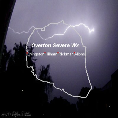
OvertonSevereWx @OvertonSevereWx
562 Followers 66 Following NOAA Weather-Ready Nation Ambassador. NWS VERIFIED/CERTIFIED #tspotter Coordinator. Weather coverage for Overton County Tn. Connect at [email protected]
Chattanooga Weather @ChattSevereWX
147 Followers 41 Following Not affiliated with any official weather source or meteorologist, just a page that "Activates" when severe weather threatens the Chattanooga Metro area
MIDDLE TENNESSEE SEVE.. @MidTnSevereWX
407 Followers 128 Following Covering @NWSNashville coverage area. Providing updates anytime severe weather threatens Middle Tennessee.
Warren Severe WX @WarrenSevereWX
318 Followers 40 Following Our goal: provide real-time, localized wx info for Warren Co. Proud member of the #tspotter program. WRN Ambassador. NWS VERIFIED/CERTIFIED.
MontSevereWx @MontSevereWx
177 Followers 9 Following Skywarn reports for Montgomery County. All spotters welcome to contribute!AlaGaFla Severe Wx @ALGAFL_WEATHER
80 Followers 6 Following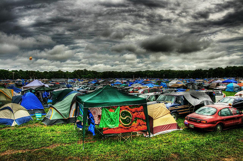
BonnarooWx @BonnarooWx
2K Followers 10 Following Unofficial Wx & Severe Wx source during Bonnaroo. Real time Rain/Storm info, forecasts when we feel like it (often). From @NashSevereWx & @CoffeeSevereWx.
Josh's Severe Weather @JoshsSevereWx
199 Followers 289 Following Meteorologist in the Carolinas with 20+ yrs of experience, called to save lives!
Dover TN Weather @DoverSevereWX
139 Followers 56 Following
Benton County Severe .. @BentonCoStrmChs
120 Followers 61 Following NWS skywarn spotter, Firefighter
KnoxSevereWx @KnoxSevereWx
111 Followers 19 Following Nowcast weather info for the Knoxville, TN area.
Jennifer ☈ ukavina .. @RukavinaBidwell
7K Followers 3K Following Meteorologist, Severe Wx Specialist, Floral Designer BROWNS/BUCKEYE fanatic. wifey to @akajeffbidwell. mama to @jeremybrush2. owns Paducah Flower Co
Williamson Severe Wx @WmsonSevereWx
136 Followers 54 Following Providing more of what you live here for , even when it's bad weather.

LawrenceSevereWx @lawrencesvrwx
453 Followers 56 Following Severe & Winter Weather Info for Lawrence County, TN! NWS-approved #tSpotter Partner
Nate's Severe Wx @NatesSevereWx
125 Followers 49 Following 20, Regional Planning major at Westfield State, love weather.
US Severe Wx Info @USSevereWxInfo
143 Followers 0 Following United States Severe Watches and Warnings. Account operated by @Nick_SNEwx, @AaronSwx
Weather & Crime @SevereWxSnow
816 Followers 1K Following I show examples of crime and black violence. I also love Mother Nature. I'll show you what the local news and mainstream media won't. Please follow for more!
Vortex: Severe Wx @VortexWxChasers
54 Followers 9 Following Storm chasers based in North Texas! chasing severe weather across the plains! Founders: Matthew Koket & Justin Rohl
Alex | Tropical WX & .. @alexballer751
299 Followers 516 Following I cover all of the Caribbean and Florida for the potential of seeing tropical cyclones! Forecaster at @IPTCWC
David @WillSevereWx
59 Followers 109 Following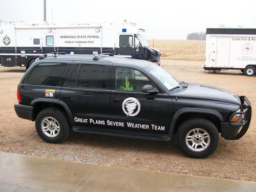
GP SevereWxTeam @GP_SevereWxTeam
73 Followers 33 Following A stormchase team located in southcentral Nebraska. We chase, report and educate about severe weather.
BGWX @BradyBGWX
6K Followers 777 Following Weather is my speciality here. Tracking Canes, Snowstorms, Severe WX. Occasional Storm Chaser. I’m dumber than I sound at times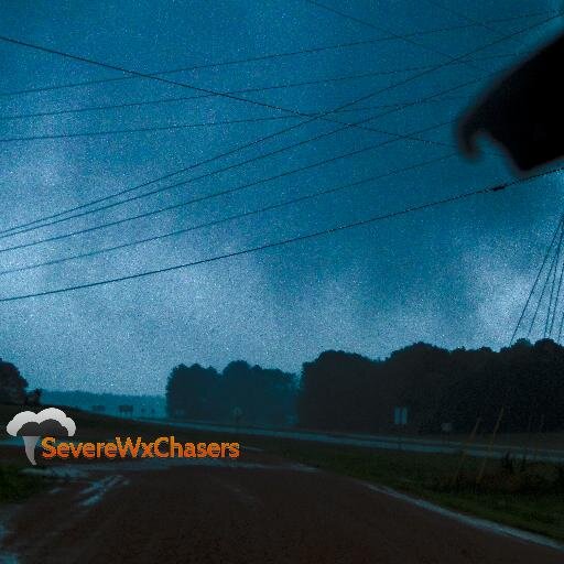
SevereWxChasers @SevereWxChasers
123 Followers 264 Following http://t.co/ZHaSJ6bkWL Severe Weather coverage for all. Home to storm chasers, weather fans, and people influences in all areas of weather.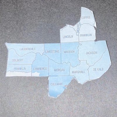
Tennessee Valley Seve.. @MatthewCarterWx
144 Followers 361 Following Severe Wx Alerts: •Alabama: Lawrence, Morgan, Limestone, Madison, and Jackson counties. •Tennessee: Lincoln, Moore, Franklin, Coffee counties.
Weather Alerts @SevereWx_Alerts
102 Followers 0 Following All severe alerts the minute they are issued.
WayneSevereWx @waynecoseverewx
47 Followers 25 Following
Storm Tech Severe WX @StormTechChaser
292 Followers 653 Following This feed will be activated during severe weather affecting the Chicago area and while we are chasing. For more information visit: https://t.co/Mlh874O9kx
SevereWxLive @SevereWxLive
150 Followers 234 Following Licensing/Brokerage company that gives you the full story of a natural disaster. Interviews,Chasing,Damage,Cleanup..we tell the ENTIRE story.
Central IN_SVR_WX @IN_Svr_Wx
5K Followers 351 Following Central Indiana Severe Wx: NWS Trained Spotter & Clinton County, Administrator ~ BRANDON CRAVEN ~

@FentressSevereWx @FentresSevereWx
72 Followers 30 Following
HartfordSevereWx @WxHartford
41 Followers 70 Following NWS Verified/Certified Spotter Coordinator/Volunteer with OHX for 10+yrs. Relocated to CT providing localized weather updates/reports focused on Hartford County
SevereWeatherLiker3 @SevereWxLiker3
190 Followers 399 Following Severe Weather & EAS enthusiast from southeast Wisconsin.
severe.Wx.Gw @Red_Eyed_Ape
25 Followers 44 Following
WayneSevereWx @WayneSevereWx
227 Followers 132 Following NWS Certified Advanced Skywarn storm spotter. Follow this page for the latest information on severe and winter weather in Wayne County.
NCOH Severe Weather�.. @NCOH_SevereWx
176 Followers 348 Following Serving North East Central Ohio with public safety alerts and weather warnings. Skywarn member. [email protected]
Severe Wx @Weatheringman
31 Followers 34 Following
Severe Weather 101 @SevereWx101
109 Followers 161 Following Accurate, honest, and reliable severe weather analysis for the contiguous United States. Facebook- @severewx101
Bedford TN Severe WX @BedfordTNsevere
56 Followers 30 Following Partners with National Weather Service of Huntsville,Nashville,and with @TNFirstAlertWX
SevereWeather @SevereWX2
16 Followers 11 Following Severe Weather Forecast, Alerts & Damage Information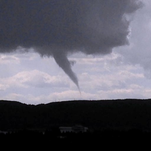
ChasinSpin @ChasinSpin
12K Followers 973 Following Science Educator, Researcher, and Severe WX Chaser for Team Dominator (and Canada). Designs and launches sensors into Tornadoes. https://t.co/FhJu3qSodK
Tennessee Valley Seve.. @ValleySevereWx
2 Followers 14 Following Covering the TN Valley (North AL, Southern Middle TN, Northwest GA) & the Metro Atlanta, GA area.
Russ D.Contreras @Stormtrek1
4K Followers 585 Following Storm chaser with Stormtrek Severe Wx Chasing.
Severe WX Information.. @SWIC_DFX
30 Followers 29 Following Severe WX Information Center - Fort Worth, TX **THIS IS NOT AN OFFICIAL SOURCE OF INFORMATION** The official SWIC office for Fort Worth, TX!
Dr. Robin Tanamachi @.. @tornatrix
3K Followers 943 Following Assoc. prof at Purdue specializing in severe wx & radar. Storm chaser since 2001. All opinions expressed here are solely mine and not my employer's. She/her
Us Severe Wx @SevereUsWx
6 Followers 2 Following Managed by Severe Weather Experts @forecasterjaret and @ryan_the_wx_man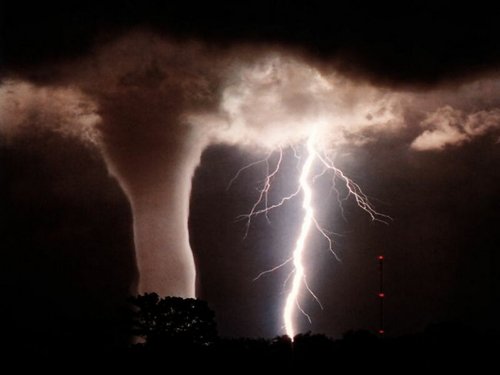
Harrison Ar. Weather @SEVERE_WX_BOONE
46 Followers 0 Following Severe Weather Updates for Harrison Arkansas and surrounding area.
Nancy Bose @SevereWxWoman
7 Followers 6 Following
WilcoSevereWx @WilcoSevereWx
14 Followers 21 Following Severe weather updates for Williamson County, TN.
SevereWeatherTeam.com @SevereWxTeam
45 Followers 267 Following
severe wx @severewxpics
38 Followers 0 Following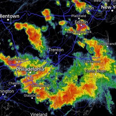
Mike Stanislaw @mikestanislaw
2K Followers 605 Following Just an unofficial voice of severe wx - PA/NJ. ⛈🌪 - Zero Meter bucket list.
Pittsburgh Severe Wx @pghsvrweather
39 Followers 0 Following Weather alerts for severe/tornado/flood events in Allegheny County, PA. Statements will include watches/warnings and risk areas 12-24 hours before the event.
MeNic @SevereWxFan
28 Followers 52 Following I'm just someone who loves weather...especially severe weather.
Cameron County Wx @CameronSevereWx
19 Followers 6 Following If you see severe weather in your area of Cameron County, please share your report and photos with us. Please include the hashtag #RGVspotter.

Jeff Willoughby @JeffSevereWx
25 Followers 44 Following Weather, country music, game show, wrestling, politics and sports expert all in one!
UtahSevereWx @UtahSevereWx
10 Followers 56 Following Providing Real Time Weather Updates for Utah County and Vicinity.
Northern Alabama Seve.. @NAST_WX24
18 Followers 102 Following
St. Louis Severe Wx @stlouiswx
6 Followers 8 Following Providing St. Louis area with severe weather information that effects your plans and your life. If you have questions or inquiries I will quench that curiosity.
Andrew Berrington @ahberrington
3K Followers 1K Following Meteorologist and research associate @ OU CAPS | M.S. OU '20 | B.S. UBC '18. Severe wx/music nut and contributor for @USTornadoes @torarchive. Opinions my own.
CASA Radar @casaradar
2K Followers 217 Following CASA advances the science & application of x-band radars for improved severe wx outcomes. Our radars send real time info to N. Texans thru local partnerships.