Search results for #cesiumjs

CO2 calculations with GeoAI Application with @qgis @CesiumJS and @QFieldForQGIS Cloud and AI. The app will be presented in @InsideIntergeo 2025. #AI #QGIS #CesiumJS


Updates on KMA(Korea Meteorological Administration)'s web based 3D weather data visualization system developed by @Gaia3D using #CesiumJS youtube.com/watch?v=LLnSWA…

Simulating dam break & rainfall flooding in real-time 3D—right in your browser. Visualize water flow, inundation depth points, and contour lines with #CesiumJS + #3DTiles. Vulnerable buildings shown with color-coded risk. #mago3D youtu.be/FRnpau-iD7g

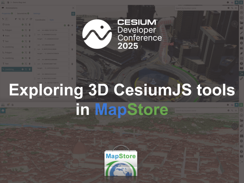
🚀 Just back from #CesiumDevConf! Our team shared how we're using #MapStore + #CesiumJS to bring 3D GIS to life: - 3D Tiles & terrain - Annotations & measurements - IFC models & digital twins Featuring real projects from Florence & Genoa 🏙️ Full recap 👉…
@Gaia3D built a real-time 3D flood simulation in the browser using #CesiumJS and Shallow Water Equation. It visualizes dam break & heavy rain scenarios. Results closely matched real flood zones. We plan to continue deeper research. #DigitalTwin #FloodSim youtu.be/IiYaQjxZ_g4


@Gaia3D has launched a 3D weather visualization system for Korea Meteorological Administration. Forecasters can now explore LDAPS & ECMWF data in 3D via CesiumJS, powered by OGC 3D Tiles & Marching Cubes. #DigitalTwin #Gaia3D #CesiumJS #3DTiles youtube.com/watch?v=ea_d0s…
We replaced simple tree models with detailed 3D ones for individually mapped ones. Now you can see real tree shapes, heights, and attributes, right in your browser with CesiumJS + mago3DTiler. github.com/Gaia3D/mago-3d… #DigitalTwin #CesiumJS youtube.com/watch?v=MaopHh…

ログインな仕組みもしょっちゅう作るけれど Gizmo(移動・回転・拡大)的なのも何回もつくってるなぁ 環境の違いにあわせたりすこし気の利いた作りを仕込みたくなるから そろそろライブラリ化きちんとしないといかんなぁ #cesiumjs

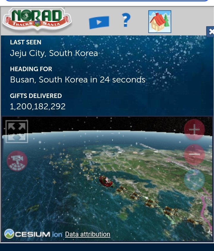
Real time Santa tracking noradsanta.org/en/map #cesiumJS

#30DayMapChallenge Day 15: My data I protested there by standing. #cesiumjs
#30DayMapChallenge Day 13: A new tool I have learned Cesium js last Saturday at foss4gjp. I tried the cesiumjs map of 長峰峠. #cesiumjs

What’s the best approach for unit testing #WebGL-based applications like #CesiumJS? 🧪 Should I stick with traditional frameworks like #Jest or #Jasmine, or explore more specialized tools? Any recommendations? #UnitTesting #WebDevelopment #JavaScript
Is anyone in the house using CesiumJS map integration in their products? Let’s connect and share experiences! #CesiumJS #WebDevelopment #Mapping #GIS

Visualize data effectively with greyscale basemaps! A clear, focused display highlights key information without distractions 🌍. See how we used global fire data to demonstrate the power of interactive maps. #DataViz #CesiumJS #GreyscaleMaps #Satellite keimaps.com/articles/self-…
Building a CesiumJS app that works offline and on on-premises deployments just got easier! 🚀 Check out our step-by-step guide to visualize Earth without internet or to self host your map. Read more: [keimaps.com/articles/self-…] 🌍✨ #CesiumJS #Offline #Geo #GIS #maps #satellite

Omar Shehata @Omar4ur
3K Followers 2K Following Open memetics R&D and evangelism Past: graphics programmer at Snapchat, @CesiumJS. Used to make flash games. Co-creator of @moveordiegame.
Cesium @CesiumJS
11K Followers 9K Following The Platform for 3D Geospatial. Tile, visualize, contextualize, and analyze your 3D data. #3DTiles #WebGL
Patrick Cozzi @pjcozzi
5K Followers 547 Following Chief Platform Officer, @BentleySystems | Founder, @CesiumJS
Monica Wamsley @MonicaWamsley
168 Followers 322 Following Living in the mountains with my family and sharing stories from the @CesiumJS community. (Views are my own.)

Andie Tursi @Andie3D
332 Followers 823 Following Sharing stories from @CesiumJS, an innovative platform for visualizing, analyzing, and streaming 3D geospatial data. Views expressed here are my own.