openglobus @openglobus
Open-source JavaScript WebGL 3D maps and geospatial data visualization engine library. Created by @MichaelGevlich. openglobus.org Joined August 2020-
Tweets159
-
Followers138
-
Following55
-
Likes2K
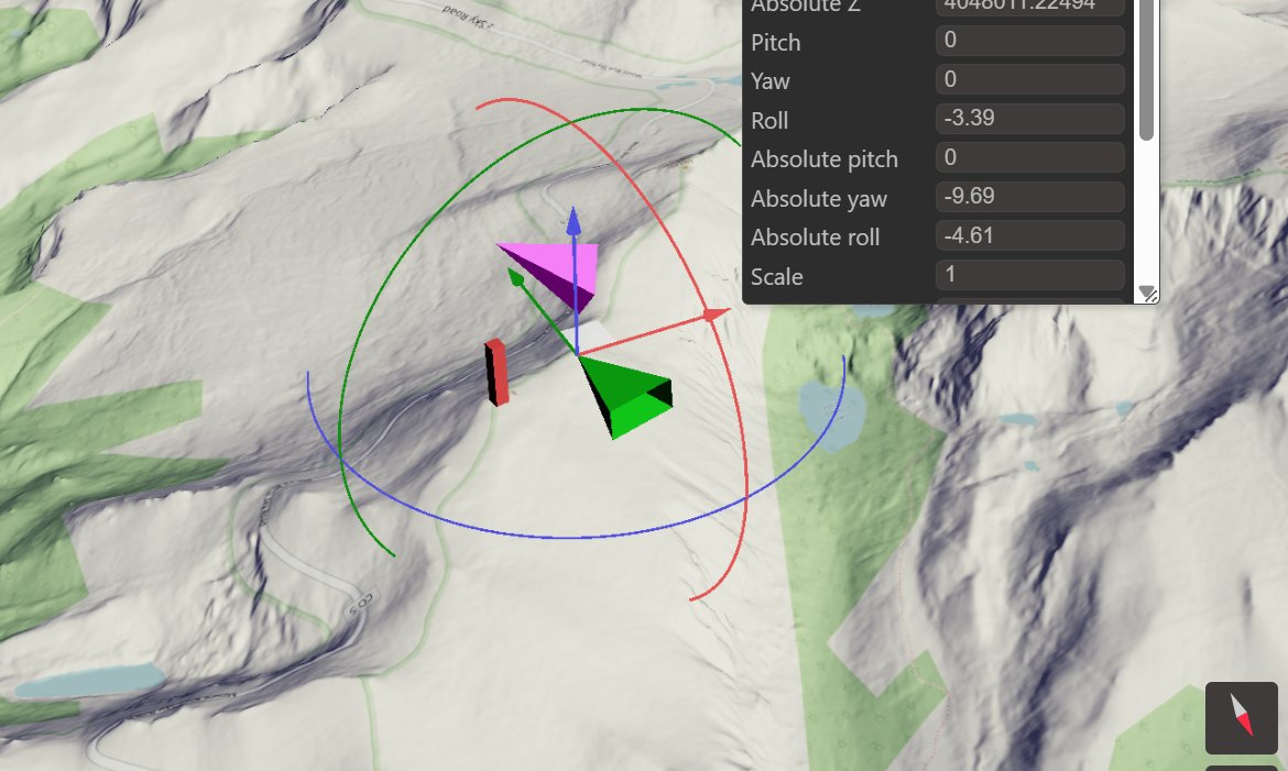
🚀Dev.: 2D orthogonal view support in OpenGlobus. Aligned with the 3D world, intuitive to use. Better for planning & measurements, and a step toward global shadows. #opensource #openglobus #indie #maps #digitaltwin #webgl #projections #greenland
🚀 Big news from Aigars Zeiza! The latest feature added to OpenGlobus is a powerful one: basic glTF support - opening the door to seamless integration of complex 3D models. We can now: - Load nested glTF objects on planetary surfaces and in local 3D scenes - Animate…
🎵 🎶A quick update from the OpenGlobus project. It's been quiet for a while, but the work hasn't stopped — development is ongoing, and the project continues to evolve. 🛠️ This week, we're happy to welcome Aigars Zeiza, who made his first commit to OpenGlobus repository. 🤝…
🛠️New examples added! OpenGlobus now demonstrates hierarchical GeoObject structures, where child objects are nested within parents. This enables: - building complex, structured objects and scenes - manipulating object groups as a single unit - positioning and animating elements…
🌍 OpenGlobus v0.25.0 Released! Major update bringing improved performance, better modularity, and powerful new rendering tools! - Migrated to Vite 6 for faster builds and better development experience - Output folder changed to ./lib for improved npm integration - Support for…
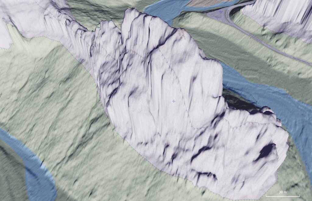
Perfect for high-resolution DSM ray calculations, mission planning, and radio signal analysis. Tool: sandbox.openglobus.org/examples/eleva… Town DSM suits for ray intersection calculations youtu.be/OXIP02kFvUI?si… via @YouTube
Yes! Stay tuned and subscribe! It will be interesting! Cheers!
Yes! Stay tuned and subscribe! It will be interesting! Cheers!

Today is the day. We're excited to announce that WeatherLayers GL is now open-source and free to use! github.com/weatherlayers/… For supporting the ongoing development and to be able to provide a tailored support, we’re welcoming a sponsorship via GitHub Sponsors.
🚀 OpenGlobus 0.24.2 Released! 🚀 A fresh update with improved flexibility and user experience! ✨ What's New? 🧭 Implemented better camera rotation – Easier alignment with the north. 🌍 Smoother globe rotation – More intuitive and responsive interactions. 📐 GeoObject angles…
The first video tutorial of how to display a high-resolution digital terrain model from GeoTiff on a 3D map youtu.be/L7jURNEPh1Y?si… via @YouTube #webgl #geotiff #terrain #opensource #maps #javascript
Watch the mouse pointer! 🖱️ The pointer always stays centered on the selected point on the map. The camera smoothly follows, keeping north fixed at the top. I've also added a little inertia to the movement, making interactions feel more natural and dynamic. Coming soon to…
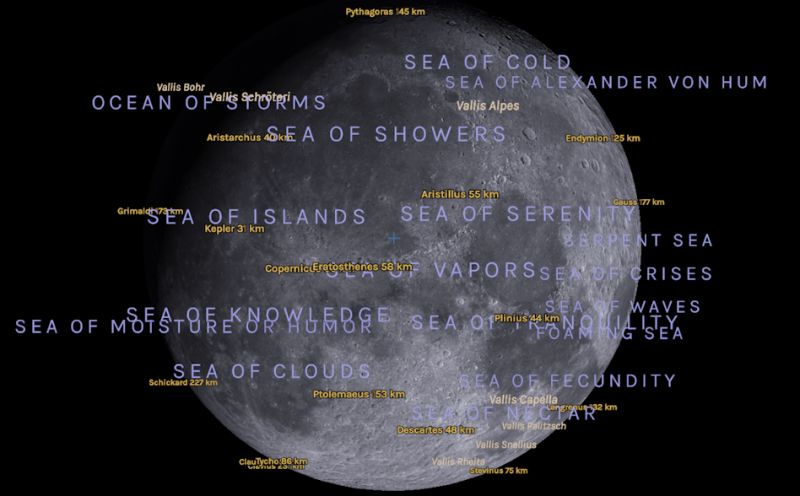
This morning, Manhattan woke up to the moon. Thanks to the geo-object editor one of the coolest environment editing plugins I can reshape reality with a few clicks. Powered by #OpenGlobus, of course. Stay tuned! Cheers! P.S. Moon coordinates and building scales are the same as…
One of OpenGlobus great features is its robust integration into complex systems. This short video showcases @microavia's UAV management system, used for 3D route planning, real-time drone control, mission tracking, and flight replay - all in one platform! The system must run…
#OpenGlobus dev. Fun with quaternions and complex GeoObjects! Like to know more!
Dev.: Added dynamic rotations for scalable geo objects. Geo objects are simply 3d objects that can contain other geo objects recursively. In this case they are improvised rotating radars. More live example will be soon. Stay in touch! Another basic GeoObject example:…
🌍 develop.: Easily customize complex 3D objects all over the globe – available now! Let me know if you'd like any further tweaks! github.com/openglobus/ope… #openglobus #gis #webgl #javascript #3d #bim #opensource
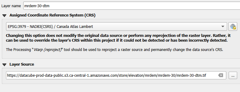
1 Cloud Optimized GeoTIFF (COG) of Canada, 30 meter resolution. VRT: …-public.s3.ca-central-1.amazonaws.com/store/elevatio…

I've just added a few rotations, it means that soon it will be able to create nested 3D geo objects! Stay in touch, it will be interesting🏀 It will be here -> openglobus.org #openglobus #webgl #javascript #quaternion #3d #opensource
Just released a new wiki on how to work with text labels and fonts! Easily add stylish labels to your map using various fonts and styles. OpenGlobus uses MSDF technology for sharp and scalable text rendering. Learn more: github.com/openglobus/ope… #maps #gis #webgl #opensource

Evan Applegate @youwillmakemaps
4K Followers 438 Following Vocational cartographer • https://t.co/X5SvX8aR3h • The best maps lie ahead, and you’re going to make them
Gal Bragg @GalBragg
1 Followers 12 Following
Jonathan E. McCottry @JEMccottry
56 Followers 218 Following PhD Student, Start-Up Investor, Former Businessman, Godfather and Uncle. CEO McCottry Foundation (501c3), CTO Weatherman

boub @boub1365907
26 Followers 999 Following
Olaf @OlafStaave
6 Followers 31 Following
kojiro @soynojuanperez
1 Followers 100 Following
Maptello @maptello
7 Followers 36 Following Web platform for managing and visualizing 3D geospatial data.
Tony Griffiths @tonegriff
563 Followers 3K Following Holyheadian in Brentford. Researching & visualising clean energy projects: Co-founder @olsights
ren @DenisSe41713125
0 Followers 11 Following

Ryan Maue @RyanMaue
133K Followers 5K Following Meteorologist PhD | Hurricane Forecasts | Look Up 🚀 | @FloridaState (10) | Go Blue Michigan (23) | NOAA/White House (45) | Cat 6 🐈 | Digital Content Creator
Chris Dalke @chris_dalke
3K Followers 739 Following autonomous boats @zydromarine, map data @vectorcharts, former eng @anduriltech — I build big robots that drive, fly and float — talks about boats a lot

Toprak Nihat Deniz @eplurum
70 Followers 256 Following Evolation is my guide 🦠 Yearn the days of first flame we light🔥 let the strings grow🪢 Software Engineer 🦀🐍
Jeff McKenna @mapserving
6K Followers 3K Following Co-founder of FOSS4G, Director of GatewayGeo, President Emeritus of OSGeo. Sharing maps with MapServer & MS4W, offering support-dev+generally having fun in life
Captain_ita @Captain_ita11
238 Followers 1K Following Follow stream FS2020 at 📺 https://t.co/0ncHqqFygT ! 🖼️ https://t.co/dtlqJ1jFxi 🎥 https://t.co/vKHIx3wDxq 📱https://t.co/9bl3swhivo no scam🚫
Tech Maven Geospatial @TechMavenGeo
168 Followers 346 Following Geospatial Data and Development Services firm Building Mobile GIS Mapping Apps Web Mapping Applications Desktop GIS Applications Consulting, Support, Data Serv
M.M.J @Hugin2Munin
1 Followers 50 Following
David Coronado @pdcoronado97
10 Followers 57 Following Biodiversidad & GIS. Ingeniero en Recursos Naturales Renovables. Cotacachi, Ecuador 🇪🇨
Jan Žák @zakjan
766 Followers 676 Following Software Engineer / Consultant · High-performance Graph and Geospatial Applications · Founder @WeatherLayers · Neo4j @get_manta · Ex-@graph_aware · 👨👩👦👦
Gauthier El Capitán ... @CartGauthier
196 Followers 2K Following Tamer of code and the datas @UTMBMontBlanc. #LiveTrail core engineer. He/him.
six @six51099183
110 Followers 2K Following
arturo montieri @arturomontieri
203 Followers 1K Following Parolografo. Una parola che non esiste neanche su Google.
koilebeit @koilebeit
19 Followers 359 Following
Michael Haberler @mhaberler1
566 Followers 2K Following nethead emeritus || Vorstand, Misanthropes United
The End @Cayza261630
67 Followers 989 Following
numworld @numworld
196 Followers 2K Following Astronomy Lover(天文爱好者), Wikimedia Contributer(维基媒体项目贡献者) 从中国到世界,从地球到宇宙
Piotr T. Dziurkowski @ptdziurkowski
8 Followers 186 Following

Nicolas @nb4ld
6K Followers 349 Following Tripote la data météo sur de gros ordis trempés dans l'huile et gavés à l'élec atomique. Fournisseur officiel de l'argent magique. Préfère les maths au blabla.
bchapuis @bchapuis
380 Followers 374 Following Passionate software engineer. Loves hacking and collaborating at the intersection of several disciplines. Location-aware Computing. Distributed Systems.

HHM2019 @HHM20191
112 Followers 4K Following
silverboi_depr @foreverpelon
296 Followers 4K Following mejor sígueme aquí @silverboi_1995 | stathead 📊

Heedong Cho | 조희�... @heedongchoxyz
21 Followers 356 Following
Primas Toubers @PrimasT4612
1 Followers 25 Following


New Eyes @murat1721970
5 Followers 26 Following
Nikko @dev_nikko
3 Followers 149 Following
xinyuanqu @Xinyuan_qu
15 Followers 404 Following
Plancton Andino @plancton_andino
891 Followers 520 Following 27 años innovando, pioneros en la columna de agua.

Deepak K J @k_j_deepak
231 Followers 1K Following Senior Software Developer #Angular | #NestJs | #Typescript | #Javascript | #NodeJs | #ExpressJs | Blog : https://t.co/UW2xmtoj9S
Masahiko Ishikawa @_ishikawa__
90 Followers 1K Following
Ghazi Mkini @GhaziMkini
0 Followers 2 Following

GIS and Science @GISandScience
30K Followers 10K Following Sharing issues and applications of geospatial technology for scientific research and understanding. Tweets by the @Esri Science Team with @deepseadawn


chongyun yang @ChongyunYang
2 Followers 16 Following

Kirk Davis @kirk5davis
7 Followers 100 Following GIS Data Admin at @WaTechGov. Spent my university years in Germany @hneeberswalde.
La GIStería @la_GISteria
1K Followers 669 Following #Diseño de #Mapas, #Webmapping y #Señalización para tu #negocio, #empresa o #proyecto !Si tienes una #idea nosotros realizamos el #mapa!
🇨🇦 GIS & Geomat... @CanadianGIS
37K Followers 23K Following Follow us for the latest information on Canadian geography, geospatial resources, cartography, remote sensing, open data, planning, smart cities, LiDAR & more
koilebeit @koilebeit
19 Followers 359 Following
arturo montieri @arturomontieri
203 Followers 1K Following Parolografo. Una parola che non esiste neanche su Google.
Tony Griffiths @tonegriff
563 Followers 3K Following Holyheadian in Brentford. Researching & visualising clean energy projects: Co-founder @olsights
Michael Haberler @mhaberler1
566 Followers 2K Following nethead emeritus || Vorstand, Misanthropes United
Ryan Maue @RyanMaue
133K Followers 5K Following Meteorologist PhD | Hurricane Forecasts | Look Up 🚀 | @FloridaState (10) | Go Blue Michigan (23) | NOAA/White House (45) | Cat 6 🐈 | Digital Content Creator
Maptello @maptello
7 Followers 36 Following Web platform for managing and visualizing 3D geospatial data.
Kontur @KonturInc
2K Followers 1K Following 🌎 Geospatial solutions for rapid decision-making. [email protected] | DM is open
Chris Dalke @chris_dalke
3K Followers 739 Following autonomous boats @zydromarine, map data @vectorcharts, former eng @anduriltech — I build big robots that drive, fly and float — talks about boats a lot
Jeff McKenna @mapserving
6K Followers 3K Following Co-founder of FOSS4G, Director of GatewayGeo, President Emeritus of OSGeo. Sharing maps with MapServer & MS4W, offering support-dev+generally having fun in life
Tech Maven Geospatial @TechMavenGeo
168 Followers 346 Following Geospatial Data and Development Services firm Building Mobile GIS Mapping Apps Web Mapping Applications Desktop GIS Applications Consulting, Support, Data Serv
David Coronado @pdcoronado97
10 Followers 57 Following Biodiversidad & GIS. Ingeniero en Recursos Naturales Renovables. Cotacachi, Ecuador 🇪🇨
Gauthier El Capitán ... @CartGauthier
196 Followers 2K Following Tamer of code and the datas @UTMBMontBlanc. #LiveTrail core engineer. He/him.
Jan Žák @zakjan
766 Followers 676 Following Software Engineer / Consultant · High-performance Graph and Geospatial Applications · Founder @WeatherLayers · Neo4j @get_manta · Ex-@graph_aware · 👨👩👦👦
bchapuis @bchapuis
380 Followers 374 Following Passionate software engineer. Loves hacking and collaborating at the intersection of several disciplines. Location-aware Computing. Distributed Systems.
Nicolas @nb4ld
6K Followers 349 Following Tripote la data météo sur de gros ordis trempés dans l'huile et gavés à l'élec atomique. Fournisseur officiel de l'argent magique. Préfère les maths au blabla.
Charlie Verdel @CSVerdel
3K Followers 4K Following Geologist in central Australia. 🇺🇸 in 🇦🇺 https://t.co/fvuMPMPayp
Pankaj Kumar @spatialdevguru
26 Followers 131 Following GeoSpatial Developer Contact me at [email protected]
David Bélanger @DavidBlanger4
321 Followers 622 Following Project Manager, National Elevation Data Strategy,Natural Resources Canada @NRCan #ccmeo #lidar #dem #dsm #opendata | Les opinions sont les miennes
Bert Temme @berttemme
2K Followers 882 Following https://t.co/tt4Ui0vnSr https://t.co/ggaTk0uHt7 https://t.co/IRmVNcwX2e
Koordinates @Koordinates
2K Followers 631 Following A geospatial data management platform inspired by cracking GIS data out of vendor silos. You can host, manage, share, publish, access, and build apps.
gdal org @GdalOrg
4K Followers 6 Following No longer here. Find us at @[email protected] GDAL is a translator library for raster and vector geospatial data formats.
Program Sam @The_Program_Sam
225 Followers 64 Following A human from Belgium creating fun and educational stuff relating to Game Development, GIS and coding 🌍

JJ Montes @jjmontes
238 Followers 309 Following Computer Science, data visualization, Devops, GIS, 3D, Gamedev, and technology and software development in general. Author of https://t.co/02fh7TkVLi and https://t.co/dKTPJt9ynO .
Laxmi Goparaju @LaxmiGoparaju
257 Followers 280 Following Scientific Advisor (Remote sensing, GIS, Forestry, and Ecology) @vindhyabachao Founder GeoSakhi
Robin Hawkes @robhawkes
13K Followers 1K Following 🐙 DataViz at @OctopusEnergy ⚡️ Obsessed with maps and energy ✨ Creator of @ViziCities 👨💻 Previously @WoodMackenzie & devrel @Mozilla

Maurice Svay 🍗 @mauriz
2K Followers 2K Following Design+Code / Software Engineer at @datadoghq / Instagram: mauricesvay
André Ourednik @andr... @andre_ourednik
604 Followers 2K Following #geography #fiction #datamining #textmining #dativiz Lecturer @EPFL & @UniNeuchatel. Loves soundscapes, maps, noospheres and moving spaces. Cf. @wikitractatus
ΛVUXI @AVUXI
502 Followers 212 Following Creators of TopPlace™ - worldwide Location Ratings & Context products for Travel & Real Estate: Location Scores, Map Layers, Descriptions, Top Areas & POIs.
data.europa.eu @EU_opendata
35K Followers 7K Following 🇪🇺 The official portal for European data. 1+ million data sets, #DataEuropaAcademy, #EUDatathon, studies, use cases, events and news. All things #OpenData.
OpenTopography @OpenTopography
10K Followers 587 Following Open access to high-resolution, Earth science-oriented topography data, and related tools & resources. US NSF supported. #lidar
Dmitriy Vorontzov @worontzov
677 Followers 199 Following I work in the field of motion design for television and presentation videos. I have extensive experience with infographics and data visualization.
Google Maps @googlemaps
4.4M Followers 59 Following celebrating 20 years of exploring the world together 🎈
Google Earth @googleearth
1.2M Followers 289 Following Discover geospatial datasets and tools, AI capabilities, and planetary-scale insights from Google Earth, Google Earth Engine and Google Maps Platform
Open Geospatial: OGC @opengeospatial
27K Followers 230 Following OGC’s member-community of experts makes location data Findable, Accessible Interoperable, and Reusable (FAIR) through #innovation #collaboration and #standardsTrends for United States
You might like