Vexcel Imaging @vexcel_imaging
Vexcel Imaging is a global leader in aerial imaging, known for developing cutting-edge aerial cameras, mapping systems, and photogrammetric processing software. vexcel-imaging.com Graz, Austria and Denver, CO Joined October 2009-
Tweets1K
-
Followers778
-
Following51
-
Likes128
Our X account is no longer active, but we are still here for you! For the latest updates, product information, and support, please visit our website vexcel-imaging.com. We look forward to connecting with you!

ONLY TWO MONTHS TO GO! 🇮🇳 We are thrilled to invite you to the Vexcel Open Day India, taking place from October 7-9, in Bangalore. Limited spots available!
ONLY TWO MONTHS TO GO! 🇮🇳 We are thrilled to invite you to the Vexcel Open Day India, taking place from October 7-9, in Bangalore. Limited spots available!
Our esteemed Chief Scientist of Photogrammetry Dr. Michael Gruber is retiring after 30 remarkable years at Vexcel! His work laid the groundwork for the success of our UltraCam systems. Please join us in extending best wishes to Dr. Gruber in his well-deserved retirement! 🎉
MEET US alongside the @vexcel_data program at the @Esri User Conference in 📍 San Diego 🇺🇸 from 15 - 19 July! Don't miss this opportunity to see the high image & data quality of our UltraCam Osprey 4.1 & UltraCam Condor 4.1 for yourself. See you soon: bit.ly/3VQkT2N
Did you know that Long Wharf in Boston was the longest pier in colonial America until 1756, surpassed only by the ports in NYC & Philadelphia? Today, it's a bustling hub of activity, offering stunning views of the harbor & serving as a popular spot for locals & tourists alike.


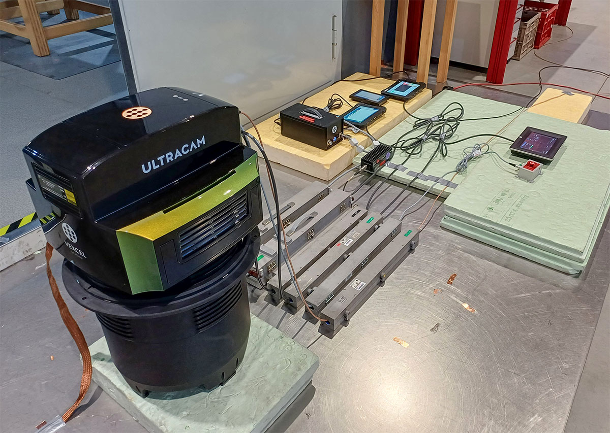
UltraCam Dragon 4.1 successfully completes CE Conformity Testing 🎉 Every electrical system in the EU 🇪🇺 must adhere to stringent criteria to ensure safety & reliability. Recently, our UltraCam Dragon successfully completed this crucial test at an accredited measuring lab ✅


Marc Muick, Head of Applied Photogrammetry - Camera & Calibration, explains the innovative Altitude Compensation method used in our UltraCam systems in the video below. More details on our custom lens technology in this blog post: bit.ly/3QLh9On
Discover the hybrid #UltraCam Dragon 4.1 - combining top imaging & LiDAR tech for unmatched detail in mapping! 📸🌍 Perfect for urban planning & environmental monitoring. Learn more: bit.ly/46pFBdA Foto credit: Diamond Aircraft #aerialmapping #geospatial


Join the Vexcel Open Day India 🇮🇳 in 📍 Bangalore from October 07 to 09! Vexcel, in partnership with HALG , is thrilled to announce the Vexcel Open Day India at the Four Seasons Hotel in Bangalore. ➡️ Registration is now open! Sign up here: bit.ly/45il6zU
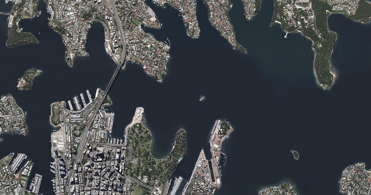
Happy World Ocean Day 2024! 🌊To celebrate this special occasion, we are sharing an image of Sydney Harbour, Australia. 🇦🇺 Australia’s busiest waterway is famous for its sparkling waters, hundreds of kilometres of shoreline, & is also vital for the city’s economic development.
Hello from a fantastic @GEOBusinessShow 2024 in London! 🇬🇧 Today is the LAST DAY! Engelbert Breg, Vexcel Sales Director for Europe, Africa & Latin America, is on site & looking forward to meeting you. Stop by our booth N° G330 to explore our innovative products!


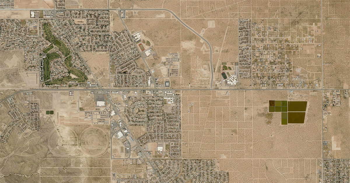
Happy World Environment Day! 🌍 This year's theme focuses on land restoration, desertification & drought resilience. 🌵 To suit the occasion, we are sharing an aerial shot of 📍 Agua Dulce, Texas, which is known for its desert climate with hot summers and mild winters.
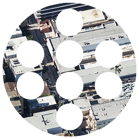
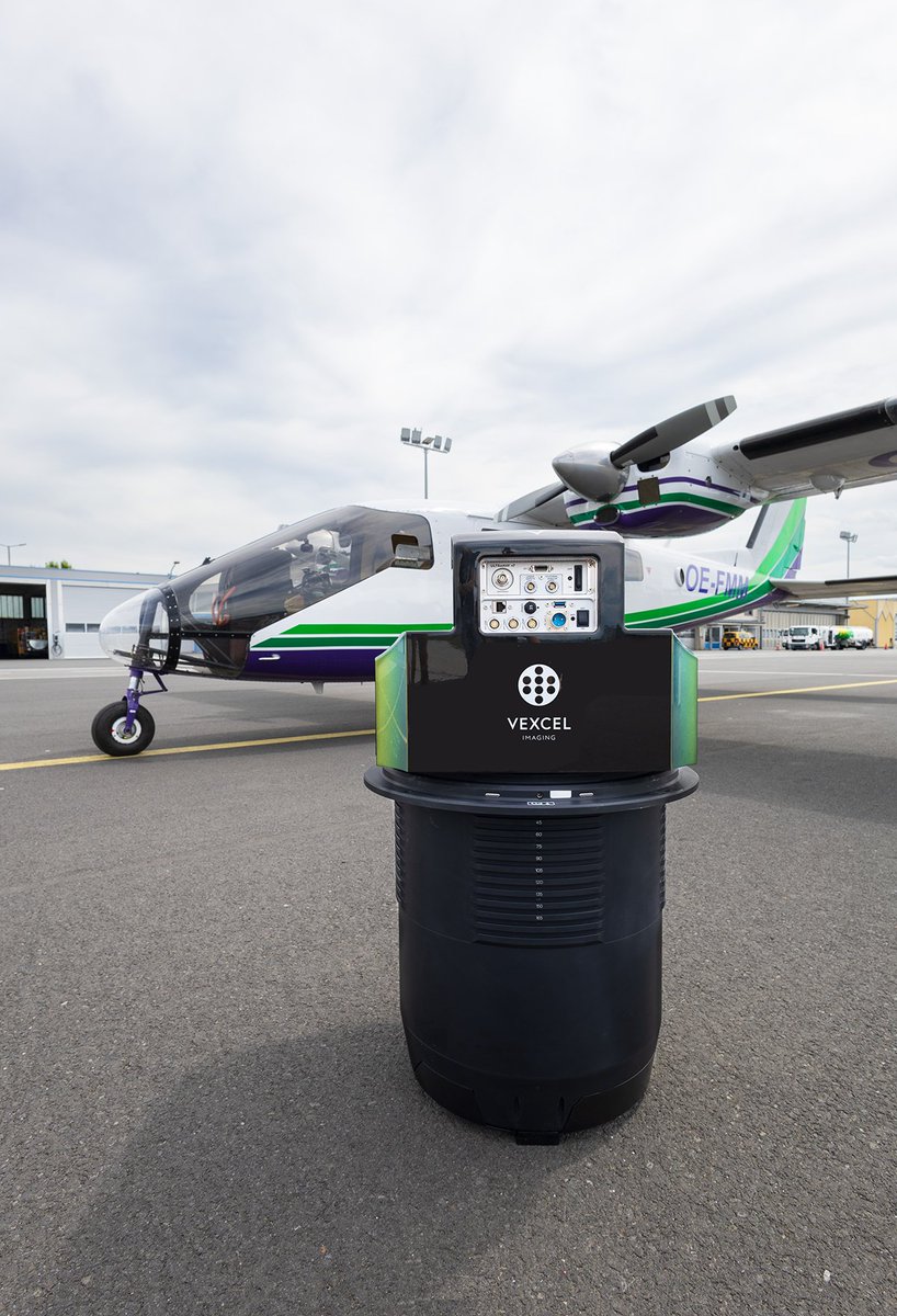
Camera design can impact geometric and visual resolution, which can affect image quality. The cones of the #UltraCam Merlin 4.1 are aligned truly nadir. The benefit❓You get a consistent scale of Ground Sample Distance (GSD) and regular pixel sizes across the entire frame.
How to choose an airborne camera for aerial survey with a 🔟-step checklist: Our colleague Charly Lothhammer, Vexcel Sales Director Western Asia & Baltic, & Sales & Support Partner Hürcan Atay summarized everything that there is to know! Find it here: bit.ly/4bmCbLm
TRIOTRONIK interviewed Head of Implementation & Support Markus Waltl! Markus on why our UltraCams have such an efficient design: "We chose to use Triotronik's SLIM patch cables. These cables have a tight bending radius, allowing us to make our camera incredibly space-efficient."


MEET US at the @GEOBusinessShow 2024 in 📍 London from 5 - 6 June! Engelbert Breg, Vexcel Sales Director for Europe, Africa & Latin America, will deliver a presentation on "Photogrammetric workflow for aerial images" on 5 June 2024 at 2:30 pm. Register: bit.ly/3waiPoX
🛫 A big milestone for us! The #UltraCam Dragon 4.1 took its maiden flight last week, soaring through clear skies with ease! Support & Implementation Engineer, Christoph Zechner, described the flight as "pleasantly uneventful." Now it's time for data evaluation & fine-tuning!


Women in Data Science Villach - an empowering event dedicated to increasing participation of women in data science! Vexcel Application Engineer Susanne Scholz had the honor of being selected as the Session Chair. Find the recorded sessions here: bit.ly/3Uwlg1H #WiDS


Choosing an aerial camera? Key tech matters! #UltraCam Merlin 4.1, like most other aerial systems on the market, is based on Bayer pattern sensors. With its true nadir cone arrangement, AMC & TPP, it sets new benchmarks within this class. Lern more: bit.ly/48rMrRb

Near Space Labs @NearSpaceLabs
929 Followers 214 Following Making high-quality Earth imagery and geospatial data widely accessible.
Uvawci @Uvawci45308
34 Followers 2K Following
melaku muka @MukaMelaku
24 Followers 735 Following
Ziv Shragai @zivshr
29 Followers 371 Following
Dylan Watts @MrWhoDat757
415 Followers 4K Following
Tony D @TonyDeMaria
267 Followers 7K Following
Clarival @Clarivalmp
1 Followers 20 Following
AmericaView @AmericaView
508 Followers 207 Following A Nationwide Consortium for Remote Sensing Education, Research, and Geospatial Applications. - Empowering Earth Observation Education
Dinesh Mainali @itsmednes14
1 Followers 195 Following
Ryan Arnaudin @arnaudin
874 Followers 5K Following ▻ Product, UX, Design, Innovation, Engineering ▻ Product Designer at @SkyfiApp prev @Thangs3D @Physna3D @Brightidea @Autodesk ▻ Playing the long game
masataka kobayashi @masatakako7092
0 Followers 3 Following
World Lidar Day @lidarday
17 Followers 69 Following
Lynwood Bishop @LynwoodBishop
4 Followers 86 Following

Corri Zoli @c_zoli
865 Followers 6K Following Director of Research/Assistant Research Professor in International Security at Institute for National Security & Counterterrorism, Maxwell & SU College of Law

大根 @dgn22554830
14 Followers 74 Following
Damon Hemmerdinger @damonhemmerding
5K Followers 3K Following Creating real estate value through Placemaking. Builder-developer-housing provider; brownfield remediator; placemaker-in-chief @campnorthend.
Nick Kadutskyi @nickkadutskyi
77 Followers 769 Following Working on the app (https://t.co/BpUAWlYmH2) that helps Upwork freelancers to get notified about filtered jobs right after they were posted. 🇺🇸🇺🇦
Brooks Laminack @BrooksLaminack
245 Followers 438 Following
UFree @FriedmanYuri
21 Followers 490 Following

KT @KT87985373
320 Followers 721 Following

Todd Stephenson @ToddStephenson3
445 Followers 2K Following co-founder https://t.co/eVyE952cbu co-founder pupsocks (acquired)
John Holder @JohnHol23515108
0 Followers 492 Following
patrick tomasiewicz @patricktrack
1K Followers 8K Following advertising strategy by day, cocktails by night

sara.sissy @sarasissy25
1K Followers 7K Following 🏳️⚧️ یک متوهم که هوافضا✈️🚀🚁 دوست داره😁 Loc:🌎 Aerospace student🚀🚁✈️ ⛔عرزشی
Ryan Stryker @StrykerFromFL
8K Followers 2K Following God 𝕏 Family 𝕏 Country 𝕏 OEF 𝕏 Florida Born 𝕏 Will it, and it will be so 𝕏 KQ4YTV 𝕏
Bousnina Sondes @Bousnina_Sondes
0 Followers 9 Following WebGIS Specialist / Remote Sensing Analyst / Topographic and Geomatics engineer
robindang @1215747aba2123
3 Followers 3K Following
T.H. @scheeinfo
4K Followers 491 Following Tech, Policy, Human Security and Tactical Sports. Bluesky: https://t.co/wYX0WBs3q7 | personal account
D MO @DMO2053264
140 Followers 2K Following Lives at Napier Court, Black Lion Road London SE5, further contact info on my business-card included in my Avatar
Surveyors @surveyors85
0 Followers 127 Following
Adio Peter @PixelsToMapsHub
2K Followers 5K Following Husband, Father, Geospatial Expert, Data Engineer, Project Lead @ Pixels to Maps Hub, Jesus Lover, Bookie, Music Lover, Fun & Adventure frick, Easy but firm
Naif Alsalem 🛰️�... @Naif1_Alsalem
700 Followers 543 Following Space-based & Airborne Remote Sensing Systems | PhD in Space & Atmospheric Physics @Sydney_Uni 🇦🇺 |
Nick Valdez @valdezvideo
98 Followers 571 Following covering hard tech - @atomsnotbits - videographer
€Ñ¡K🛰️🌎 @EsunoKine
634 Followers 4K Following La indiferencia es el peso muerto de la Historia. A.G. #Geographer #RemoteSensing🛰️🌎
trap fone @trapfoner
0 Followers 347 Following
MIHALACHE DANIEL ZORI... @MZorin65538
263 Followers 7K Following
Robert Kuloba @rkuloba
282 Followers 3K Following Economic policy analyst and research interested in development and governance issues
adewumi mayowa @OBA_ADEWUMI
19 Followers 131 Following A young Engineer 👷♀️ || FOOTBALL LOVER ❤️⚽❤️||CHELSEA FAN ❤️🤍💙💛🖤|| LEARNER 📕. who can only solve a few problems of his

JHIH-SIANG LIU @garden94030
69 Followers 1K Following PLA Researcher; Following, retweets and links ≠ endorsement.
J Shields @JamesAn13514562
588 Followers 699 Following Facts do not matter to those who do not think. A strong Dollar is good for America. Save American ranches & farms.
Gaurav Mukherjee @GauravMukherj18
162 Followers 1K Following Space & Science Research ,Exploration , Astronomy , Orbital mechanisms and Rockets .!!

nick defelice @larchitetto0
207 Followers 373 Following interests: markets, gametheory, psychology, tech, energy
Filip investing in sp... @fikocian
2K Followers 2K Following 6 years at the intersection of space, finance and strategy. Investor at Expansion Ventures. Writing "Intersections by Filip". Opinions mine.
Getmapping @GetmappingLtd
2K Followers 3K Following See More. Know More. Do More. Geospatial data made easy with high-resolution imagery, expert surveys, and on-demand content.
xyHt @xyHt
2K Followers 277 Following Stories from the worlds of precision measurement and location: the leading geospatial magazine.
Fondazione Bruno Kess... @FBK_research
10K Followers 10K Following 🇮🇹 🇪🇺 Research Institute on #AI #QuantumTech #EcologicalTransition #DigitalTransformation #DigitalAgriculture #DigitalHealth #DigitalIndustry #Cybersecurity
3DOMFBK @3DOMFBK
980 Followers 830 Following 3D Optical Metrology unit of @FBK_research, involved in #photogrammetry #3D #metrology #AI #geomatics #heritage #geoinformatics #Innovation #Research
Ordnance Survey of NI @osni_maps
1K Followers 183 Following Ordnance Survey of Northern Ireland (OSNI) is the official producer of high quality, accurate and current geographic mapping data for Northern Ireland.
Qumulo @qumulo
3K Followers 2K Following Qumulo offers a radically simple way to manage petabyte-scale data anywhere – edge, core or cloud – on the platform of your choice.
GPI Geospatial @GPIGeospatial
193 Followers 298 Following GPI Geospatial is a premier mapping firm for all forms of Transportation in North America.

Roger🐺 @Roger_Nock
951 Followers 2K Following Flying through uncharted territory since 2012. Airborne Ops Manager. Also a RAFAC volunteer. Views my own.
Hexagon @HexagonAB
13K Followers 751 Following When it has to be right. Hexagon - the global leader in measurement technologies. From micron to Mars, we measure what matters for the future.
Geospatial Insurance ... @gic_org
544 Followers 494 Following High-resolution aerial imagery and geospatial data for insurance & emergency disaster response. The GIC is an at-cost, member-driven initiative of the NICB.
DAT/EM Systems @datemsystems
359 Followers 270 Following Developers of digital photogrammetric mapping systems
Geo-matching.com @Geomatching
18K Followers 19K Following https://t.co/3gwCkbV0gR The world’s largest product platform for surveying, positioning and machine guidance.
AXIS GeoSpatial LLC @axisgeospatial
268 Followers 373 Following AXIS GeoSpatial employing innovative measurement technologies to capture #geospatial data for integration into your Civil Engineering or #GIS applications.
NV5 Geospatial @NV5Geospatial
6K Followers 4K Following Formerly Quantum Spatial, we are the geospatial pioneer: Delivering data + analytics, providing geospatial insights to government and corporate organizations.
Geospatial World @geospatialworld
33K Followers 3K Following Your trusted knowledge source for all things geospatial. We delve into tech convergence and pivot to Industry 4.0 via Digital Transformation and Sustainability
Esri @Esri
190K Followers 66K Following Esri builds #ArcGIS, the leading location intelligence and spatial analytics software for mapping, 3D GIS, imagery, and geospatial app development.
SPAR Events @SPAR_Events
2K Followers 424 Following Now part of Geo Week! Organizer of conferences for professionals involved in end-to-end 3D imaging technologies.
Geo Week @GeoWeekExpo
5K Followers 400 Following Geo Week is a news site and technical conference & expo at the intersection of geospatial and built world technology.
Paul Steckler @bricin
344 Followers 91 Following Marmot-whisperer, audiobook aficionado. Built a lot of software you've used over the years. COO at https://t.co/NvcLayd4XU, a future of distributed intelligence.GEODIS_EN @GEODIS_EN
60 Followers 61 Following GEODIS is a leading European company in the fields of geodesy, photogrammetry and remote sensing.
Dept. of Agriculture @USDA
1.1M Followers 3K Following Leadership on #food, #agriculture, natural resources, #rural development, #nutrition, & related issues based on public policy, science, & effective management.
GeoToolBox Ibérica @gtbiberica
82 Followers 6 Following Asesoría, venta y soporte de software y hardware fotogramétrico y relacionado (cámaras aéreas, LiDAR, restituidores digitales, generación de MDT's, etc.).
Aerometrex @aerometrex
1K Followers 423 Following Aerometrex is a geospatial tech company with a focus on providing data-driven insights for a range of business applications globally.
RWW Geo @RWWgeo
664 Followers 423 Following Follow RWW Geo for the latest news on geolocation technology from http://t.co/nKd8zuhSZc
USGS @USGS
779K Followers 93 Following Science is only a tweet away. Tweets do not = endorsement: https://t.co/VoRuucTNuK
OpenStreetMap @openstreetmap
83K Followers 219 Following OpenStreetMap is the free editable map of the whole world. It is made by people like you! @[email protected]geocommons @geocommons
10K Followers 2K Following A community for anyone to share geographic data, maps and analysis. Powered by @ArcGIS + @EsriDC
Directions Magazine @directionsmag
15K Followers 124 Following Your home for geospatial news, articles, webinars and podcasts since 1998!Dr. Charles O'Hara @Spatialis
150 Followers 204 Following SIS provides software-based map accuracy and content enhancement solutions that enable its customers to map with confidence. Visit http://t.co/ACmYOGpev0.TheGeoExperts @TheGeoExperts
455 Followers 274 Following Daily improvement of communication and education of GIS, Land Surveying, and Engineering as we learn and understand each other's needs.
Apogeo Spatial @ApogeoSpatial
1K Followers 949 Following Apogeo Spatial communicates the power of geospatial tools and remotely sensed data for long-term sustainability of the planet and people.
Keystone Aerial Surve... @KASurveys
272 Followers 93 Following Headquartered in PA with offices in MD, SC, KS, CO, NM, TX, CA, and NV. Keystone is a nation-wide aerial data acquisition and processing service provider.
CATALYST.Earth @pcigeomatics
5K Followers 3K Following CATALYST is a PCI Geomatics brand. Earth Data, Simplified.
Spatial Media - GeoTe... @SpatialCORE
33K Followers 3K Following Addressing developments in geospatial technology, online learning and more. We support media that occupies a place.

Intelligent Geo @gisIMAGE
96 Followers 188 Following A Perspective on The Internet of Things Geospatial. Reality capture and analysis from a World of Sensors - from Space, Air and Ground.
GIM International @gim_intl
9K Followers 2K Following GIM International focuses on reporting the latest news and communicating new developments and applications in geospatial surveying.
Tina Cary @tinacary
709 Followers 551 Following Retired 10 years now! I do a lot of knitting and walking and reading, often have a jigsaw puzzle underway.
Sensors & Systems @SensorsSystems
5K Followers 2K Following Sensors & Systems is focused on geospatial technologies that help us observe, measure, monitor and analyze Earth.ISCIENCES, LLC @isciences
1K Followers 977 Following ISCIENCES, LLC provides expertise on water and climate, corporate sustainability, remote sensing, and human security.
MAPPS @MAPPSorg
5K Followers 649 Following MAPPS is the national association for private sector geospatial firms. MAPPS provides its 180+ member firms opportunities for networking and public policy.
Esri Canada @esricanada
13K Followers 3K Following Esri Canada provides geographic information system(GIS) solutions that empower people to make informed decisions using the power of mapping & spatial analytics.

MundoGEO @MundoGEO
17K Followers 11K Following MundoGEO Connect 2026, de 16 a 18 de junho no Expo Center Norte - Pavilhão Azul, em São Paulo (SP), Brasil
ASPRS @ASPRSorg
4K Followers 48 Following Welcome to the official X page for the American Society for Photogrammetry and Remote Sensing. LinkedIn: https://t.co/8Vpn4kKNld IG: https://t.co/mUmEfRsiWz
Alexander Wiechert @alwieche
12 Followers 1 Following
GIS Pathway Jobs @GISJobs4u
2K Followers 759 Following GIS Jobs & Careers! Find that perfect job or post your open position for 45 days for only $50.Trends for United States
You might like