SpatialExplorer @SpatialExploler
The Big Picture spectator ;) The world. Joined February 2018-
Tweets406
-
Followers83
-
Following552
-
Likes2K

CIA Built "12 Secret Spy Bases" In Ukraine & Waged Shadow War For Last Decade, Bombshell NYT Report Confirms zerohedge.com/geopolitical/c…
Ed Fairburn repurposes old maps, transforming them into beautiful, highly-detailed portraits, merging landscape and humanity, reminding us that we are a product of our environment & vice versa [📹 edfairburn]
A striking example of the usefulness of historical aerial/satellite photographs/images.⏱️🛩️🛰️

A striking example of the usefulness of historical aerial/satellite photographs/images.⏱️🛩️🛰️
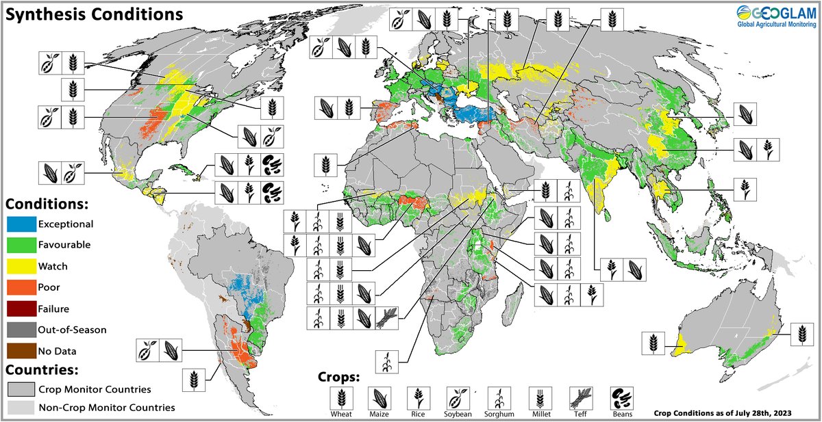
Out today: The #CropMonitor August reports. #CM4AMIS, #CM4EW, and the Global Crop Monitor showing crop conditions across the world. Full reports available at cropmonitor.org
Next level of #real_estate #marketing!🤯 Source: youtu.be/pIMwhcszYs8?t=… (Hi-res)
Great tool for #stereoscopic observations 👏, although it needs some more tweaks! It reminded me Stereo GE Browser (for #GoogleEarth). Get 👓 and enjoy! #Photogrammetry #3D

Great tool for #stereoscopic observations 👏, although it needs some more tweaks! It reminded me Stereo GE Browser (for #GoogleEarth). Get 👓 and enjoy! #Photogrammetry #3D

What is ignored or neglected by the media -- but will be studied by historians? Here's the full list of 25 examples:
A blog post by LinkedIn user Anass YARROUDH 👇 Introducing segment-lidar: Revolutionizing Unsupervised Instance Segmentation of Aerial LiDAR Data medium.com/@yarroudh/intr… #segmentanything #geospatial #lidar
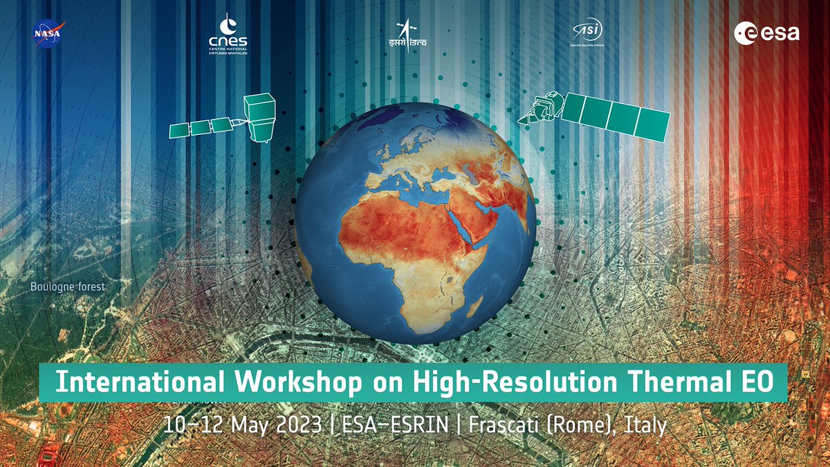
International Workshop on High-Resolution #Thermal #EO 🛰️- Day 2 NOW LIVE! youtube.com/live/7PoaeqqNY… / more info thermal2023.esa.int

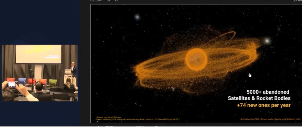
#GWF2023 | Kees Van Der Pols, @ClearSpaceToday explains about 3 types of Space Debris: 1. We can see & know their position 2. We know exist but we don’t know their position 3. We don’t see but we know can cause severe problems #GWF #Spacedebris #SpaceJunk #geospatial #Space
Excellent #uav #point_cloud collection animation

Excellent #uav #point_cloud collection animation
This is machine learning training on landscapes. StyleGAN3 is a generative adversarial network particurarly effective in generating photo-realistic faces [read more: buff.ly/3siB4Yl] [📹 Gene Kogan]

✨ Today we are ready to take AI Graphics to the next level: full volumetric photorealistic NeRF rendering on the web. All in realtime! What you see is what you get for photorealistic 3D is finally here! Starting with the the Fields Editor soon you’ll be able to reshoot in…

Determine which satellite bands you need for your research. The interactive Landsat Spectral Characteristics viewer helps researchers find the right combination. landsat.usgs.gov/spectral-chara…
Amazing analogue technique, now similar effects are created by algorithms...
Amazing analogue technique, now similar effects are created by algorithms...
Absolutely amazing perspective on rubbing Your 👀
Absolutely amazing perspective on rubbing Your 👀
Amazing explanatory video and channel. 👏How does #Starlink #Satellite #Internet Work?📡☄🖥 youtu.be/qs2QcycggWU via @YouTube

Welcome to space! First contact with #EnMAP has been established 📡. The satellite 🛰 will now be commissioned, its systems powered up & the target orbit adjusted.
"The Dirty Work Of Going Through Old Positions On Bank Balance Sheets Is Being Done Around The Clock As We Speak" zerohedge.com/markets/dirty-…

Ceorwu @Ceorwu735
27 Followers 1K Following
Turar @Turar887463
23 Followers 1K Following
Thairez @Thairezrwt
35 Followers 4K Following Don’t let a little dispute break up a great friendship.
Anil Bhandari @Anilbhandari80
114 Followers 264 Following
Kestawndee @KestawndeetnFo
34 Followers 4K Following
Randolph @kohagurayu35381
104 Followers 7K Following
Barcelona Fan @mphilisingonya
0 Followers 61 Following
Edwina @edwina44flander
274 Followers 3K Following
Luca Morelli @lcmorelli3
45 Followers 78 Following
Barry MacDonald @MacDonaldBarry
43 Followers 1K Following
BoxMica @boxMica
1K Followers 464 Following Intelligence as a Service. Get Actionable Intelligence, With Rapidly Delivered Briefings, For Persistent Geospatial Monitoring Missions. 🇺🇸
Maciej Cepnik 🇵�... @CepnikMaciej
4K Followers 3K Following Every day I #bitcoin. Social Media Coordinator at @bitrefill. Canadian refugee and orange piller in Mexico, DM for anything. 🇲🇽🇵🇱
Qiusheng Wu @giswqs
46K Followers 4K Following Associate Professor @UTKGeography | @Amazon Scholar | Talk about #opensource #geospatial #dataviz #EarthEngine
GIS Resources @GISResources
2K Followers 640 Following GIS Resources is global platform for geospatial latest news & insights, developments, jobs, webinars, articles, data, conferences and tenders.
SilviLaser 2025 @Silvilaser25
697 Followers 539 Following 📅September 29 - October 3, 2025 📍Quebec City, Quebec, Canada 💻 https://t.co/pGW5uSBEBH We have moved over to BlueSky - please join us there! @silvilaser2025
Azam @Azam109196961
0 Followers 2 Following
Urban Sky @urbanskyimaging
699 Followers 582 Following Better imagery. Better planet. Zero-emission Remote Sensing from the Stratosphere, Driving Insights to Improve our World 🌎 📸
Skill Based IT - SBIT @sbit_com_bd
104 Followers 672 Following We are your expected software home who is ready to Develop, Implement ERP solution on different domain and any kinds of customized software solution provide.
Mike Wulder @mikewulder
14K Followers 6K Following Senior Research Scientist with the Canadian Forest Service. 🍁 #Landsat super-fan. #Lidar. #Forests. #Remotesensing. 🌲🛰 Member of the #OrderOfCanada. 🎖
Canadian Cartographic... @CdnCarto
2K Followers 985 Following For anyone with an interest in #maps We encourage all cartographers, & all those passionate about mapping, geography, GIS & data visualization to join the CCA

Hugo Herrador @elanio_herrador
563 Followers 3K Following Spatial data visualization • GIS • Webmapping • @Angular • We dive and we socialize, we struggle and we strive just to stay alive
Blender India @india_blender
228 Followers 1K Following Subscribe to our YouTube Channel - https://t.co/pGVa97aPYR Do subscribe to our Odysee Channel https://t.co/9XDufadxgh
Leszek Markiewicz😾 @kotym_doomer
47 Followers 1K Following elegia dla kociaków, afirmacja przegranego życia
Africa GeoPortal @AfricaGeoPortal
2K Followers 646 Following The Africa GeoPortal is the best location for geospatial tools, data and training, free to people working on geospatial challenges in Africa.
The Marine Geomatics ... @TheLecoursLab
355 Followers 426 Following We conduct cross-disciplinary environmental research using geospatial technologies & spatial sciences, with a particular focus on bridging geomatics & ecology.
Sayan Das @SayanDa39902321
0 Followers 52 Following
labarde julien @M_Bungaloww
5 Followers 140 Following
Martin Tomko @dinomir... @dinomirMT
2K Followers 5K Following Understanding and supporting people in their spatial interactions through computational #spatial #data #science #giscience @unimelb, own views, support 🇺🇦
Eitan U. Gad @EitanGad
61 Followers 395 Following
Jeff McKenna @mapserving
6K Followers 3K Following Co-founder of FOSS4G, Director of GatewayGeo, President Emeritus of OSGeo. Sharing maps with MapServer & MS4W, offering support-dev+generally having fun in life
Patrick Griffiths @pdgriffiths81
235 Followers 583 Following Earth observation scientist and EO data engineer at ESA.
Arjen Vrielink @arjenvrielink
2K Followers 822 Following Owl at @satelligenceEO, RemoteSensing, OpenSource, theSwarm, Containers, Patterns. “Bacteria that turns shit into fuel” - the Mouth of Joe.

Ahmɑd @Ahmadjalil92
427 Followers 3K Following A Coffeeholic Geographer 🗺 interested in 🪐 📸 & Good Food🍴
Samuel🇧🇷 @CouraSamuel
859 Followers 4K Following
Eliav S-T @est987
729 Followers 3K Following Environmental Planner, GIS Specialist and Nature Enthusiast #RiverRestoration #Rewilding #Water #RenewableEnergy #SustainableAgriculture #OpenData
James O'Connor @James_O_Connor1
414 Followers 666 Following I'm interested in satellites, cameras, computers and lasers. @satellitevu

yalçın yarar @yarar74
20 Followers 152 Following
çiçek @iek20169384
0 Followers 41 Following
Ernus Samidov @evrenerc
99 Followers 3K Following
Metin V. Bayrak @VeliMetinBayrak
788 Followers 2K Following Felsefe, sanat, eğitim ve mimarlık ile ilgilenir. Philosophy deals with art, education and architecture. Activist & Diemer in DiEM25 Istanbul1dsc
oki @okangirsen
91 Followers 3K Following
GeoDataScience @geodatascience
7K Followers 2K Following Twitter feed for the Geographic Data Science Lab at the University of Liverpool.
Simon Kuestenmacher @simongerman600
258K Followers 216K Following German #geographer and #demographer in #Melbourne. I curate #maps and #data that explain how the #world works. Obviously all opinions are my own...
Spatial Aims @spatialaims
984 Followers 2K Following Geospatial videos, articles, Maps and news relating to #Geomatics, #GIS, #RemoteSensing, #Surveying, #GPS and #Geospatial Technology.
vGIS @vGIS_Map
2K Followers 1K Following Leading #AugmentedReality #AR-powered Construction Coordination platform. #BIM, #GIS, #3DScans and #RealityCapture. @Autodesk, @Esri and @Microsoft partner.
OSINTdefender @sentdefender
1.5M Followers 1K Following Open Source Intelligence Monitor focused on Europe and Conflicts across the World. RT ≠ Endorsement. Want to Support my Work? https://t.co/PcUbewvWPr
Ewa Zajączkowska-Her... @EwaZajaczkowska
183K Followers 2K Following Member of the European Parliament. Journalist. Conservative liberal.
SatVu @satellitevu
2K Followers 926 Following The world’s thermometer • 🛰️ For a safer and more sustainable earth #netzero #sustainability #activitymonitoring #builtenvironment #solar
Sven Grahn @svempa46
322 Followers 118 Following I rymdbranschen sedan 1962. Arbetade heltid på Rymdbolaget 1975-2006. Bolagets tekniske direktör vid pensioneringen. Hopelessly romantic about spaceflight.
Radek Pogoda @RadoPogoda
29K Followers 1K Following Nie da się obudzić kogoś, kto tylko udaje, że śpi.
Photogrammetry @ TU W... @photo_TUW
571 Followers 390 Following @phototuw.bsky.social Photogrammetry research unit @geodepartment at @tu_wien. Research on various fields of photogrammetry & developing OPALS software.

EuroSDR @EuroSDR
666 Followers 273 Following Linking #NMCAs with #ResearchInstitutes & #Universities in #Europe for the purpose of #research in #spatial data provision, management & delivery 🌍🛰️

Avenza Systems Inc. @Avenza
1K Followers 138 Following #MapsInAdobe @CreativeCloud: MAPublisher for Illustrator & Geographic Imager for Photoshop. Makers of the mobile offline @AvenzaMaps app for iOS and Android.
Andrzej Szczęśniak @SzczesniakA
6K Followers 1K Following Energy (oil, gas, power, RE, climate) markets, strategy & security Poland 🇵🇱 Energia (paliwa, gaz, energetyka, OZE, klimat), rynki, strategia & bezpieczeństwo
BoxMica @boxMica
1K Followers 464 Following Intelligence as a Service. Get Actionable Intelligence, With Rapidly Delivered Briefings, For Persistent Geospatial Monitoring Missions. 🇺🇸
Jack Rhysider 🏴... @JackRhysider
164K Followers 4K Following Creator of @DarknetDiaries. Tell me a good hacker story. 💻🔦⤵️🐰🕳️ Discord: https://t.co/qxanMuJ5X2
GEOGLAM Crop Monitor @GEOCropMonitor
5K Followers 189 Following Transparent, Multi-source, Consensus Reports on Global Crop Conditions | The @G20_GEOGLAM Crop Monitor for @AMISOutlook & Crop Monitor for Early Warning
Lunas_Visualization @Lunas_3D_render
70 Followers 99 Following We create hyperrealistic 3D images, animation videos, VR & panoramic tours, 3D marketing software for real estate & interactive product customizers.
Twinmotion @Twinmotion
13K Followers 93 Following Twinmotion is an intuitive 3D real-time visualization software that enables anyone to quickly produce images, videos, panoramas, and interactive presentations.
NorthStar Earth & Spa... @NorthStarEandS
921 Followers 231 Following Empowering humanity to preserve our planet. // Nous donnons à l'humanité le pouvoir de préserver notre planète. #SpaceSustainability #BigData #AI
Logo Histories @logohistories
18K Followers 19 Following Design history made fun. Add to your understanding and learn from the world’s greatest brands. Start here 👇
LogoArchive @LogoArchive
103K Followers 146 Following Modernist logo archive, international research initiative & zine series. A project by @richbaird
ShadeMap @shademap
4K Followers 51 Following The ShadeMan. Creator and maintainer of https://t.co/6VgsE5s1xF. Author of mapbox-gl-shadow-simulator and leaflet-shadow-simulator on NPM.
Gabe Dominocielo @dominocielo
2K Followers 1K Following Co-Founder of @umbraspace 🇺🇸 “Unreasonable obsession with unit economics.”LeicaGeosystems @LeicaGeosystems
17K Followers 697 Following Leica Geosystems products and services are trusted by professionals worldwide to help capture, analyse, and present spatial information. Part of @HexagonAB
Fondazione Bruno Kess... @FBK_research
10K Followers 10K Following 🇮🇹 🇪🇺 Research Institute on #AI #QuantumTech #EcologicalTransition #DigitalTransformation #DigitalAgriculture #DigitalHealth #DigitalIndustry #Cybersecurity
SmartForest4.0 @SmartForest_SFI
1K Followers 828 Following 💡SmartForest🌲 bringing Industry 4.0 to the 🇳🇴 forest sector. A Centre for Research-Driven Innovation @NIBIO_no @UniNMBU @UniOslo
LaurieWired @lauriewired
97K Followers 294 Following researcher @google; serial complexity unpacker; https://t.co/Vl1seeNgYK ex @ msft & aerospace
RealityScan @RealityCapture_
15K Followers 217 Following You scan the world. We make it real. Create detailed 3D models from images and laser scans with ease. Use #RealityScan to be featured.
International Journal... @IJRemoteSensing
2K Followers 29 Following Communicating remote sensing science. Since 1980. Published by @tandfonline. #RemoteSensing
Aravind 🌍 🛰 @aravindEO
8K Followers 1K Following Founder & CEO, @terrawatchspace | Demystifying Satellite Data and its Applications for Businesses, Climate & Environment | Earth Observation Strategist

Robin Cole @robmarkcole
11K Followers 4K Following Tackling the worlds toughest challenges with AI & ML applied to satellite & aerial imagery https://t.co/QmbOWgdfAZ
uɐɥdǝʇS @StephanSturges
5K Followers 4K Following Amateur cybernetics and retrophrenology. I make all the AI for all the drones. follow != endorsement, I'm watching you weirdos

Soar @Soar_Earth
7K Followers 833 Following Welcome to the new atlas. 🗺️ Explore at https://t.co/wN2Ui7lnyr
USGS National Uncrewe... @USGS_UAS
1K Followers 208 Following This is an archived account and is not being updated. For the latest updates follow @USGS.
Zoom Earth @zoom_earth
204K Followers 1K Following Interactive weather map and hurricane tracker. Get our app 👉 https://t.co/jIqXDEkmV8
Open source BIM @osbim
5K Followers 14 Following The open source BIM collective connects and supports open source BIM projects and initiatives.
Institute for Photogr... @IfpStuttgart
311 Followers 50 Following Photogrammetry, Remote Sensing, Geoinformatics and Computer Vision.
AerialServices @AerialServices
737 Followers 139 Following Team of Aerial Photography, Photogrammetric Mapping, and Geospatial Solution experts
IGN France @IGNFrance
17K Followers 1K Following Ce compte n’est plus actif #HelloQuitteX – Suivez nous sur Linkedin, Bluesky, Mastodon et tous nos réseaux sociaux pour retrouver toute l’actualité de l’IGN 👇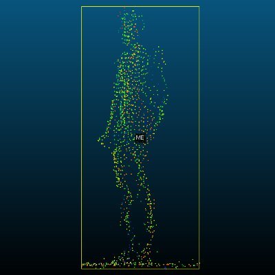
JG_RS_GIS @jg_rs_gis
132 Followers 778 Following All things Remote Sensing and Geographic Information Science 🛰️📡🛩️🤖 Currently working with Remote Sensing @OrdnanceSurvey All views are my own.
3D Geoinfo @TU Delft @tudelft3d
2K Followers 165 Following 3D Geoinformation Research Group at @tudelft, the Netherlands
Vexcel Imaging @vexcel_imaging
778 Followers 51 Following Vexcel Imaging is a global leader in aerial imaging, known for developing cutting-edge aerial cameras, mapping systems, and photogrammetric processing software.
3DOMFBK @3DOMFBK
980 Followers 830 Following 3D Optical Metrology unit of @FBK_research, involved in #photogrammetry #3D #metrology #AI #geomatics #heritage #geoinformatics #Innovation #Research
Dr. Joanne C. White @Joanne_C_White
3K Followers 2K Following Research Scientist @PFC_CFS @NRCan | Adjunct Prof @ubcforestry | Alum @helsinkiuni | #forests #forestinventory #lidar #Landsat #CFSEFI #remotesensing 🌲🛰️
3DForEcoTech @3DForEcoTech
894 Followers 24 Following COST Action CA20118 Three-dimensional forest ecosystem monitoring and better understanding by terrestrial-based technologies
Worldview Earth Data ... @WED_explorer
2K Followers 354 Following Watching our planet 🌍 from space 🛰 to identify climate change, deforestation & natural disasters. #EarthObservation #ClimateChange #Environment
ForestSAT @ForestSAT
3K Followers 846 Following Promoting the application of spatial analysis technologies for forest observation and analysis.

Nearmap @nearmap
13K Followers 3K Following Industry-leading Location Intelligence powered by aerial imagery, AI, and geospatial solutions.
Foursquare Studio @FSQStudio
2K Followers 147 Following 🌍 Advanced geospatial technology that is accessible, scalable and intuitive. Part of the Foursquare family.Trends for United States
You might like