JG_RS_GIS @jg_rs_gis
All things Remote Sensing and Geographic Information Science 🛰️📡🛩️🤖 Currently working with Remote Sensing @OrdnanceSurvey All views are my own. Joined September 2018-
Tweets241
-
Followers132
-
Following778
-
Likes114

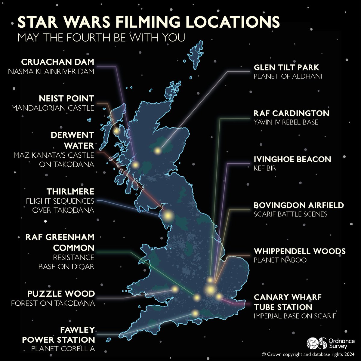
May the fourth be with you! 🌌 Have you visited any of these locations? #StarWarsDay #MayThe4th
Bernhard Schachinger meets other participants of the successfully completed VOLTA (innoVation in geOspatiaL + 3D daTA) project in Italy! It was once again fantastic to exchange professional knowledge through presentations and discussions. @VOLTA_MSCA @3DOMFBK @FBK_research


Did you know BGS uses #Minecraft to help make geology more accessible? We've built 5 worlds to allow you to explore underground: we use real geological data to show what it's like under the surface. 🧵

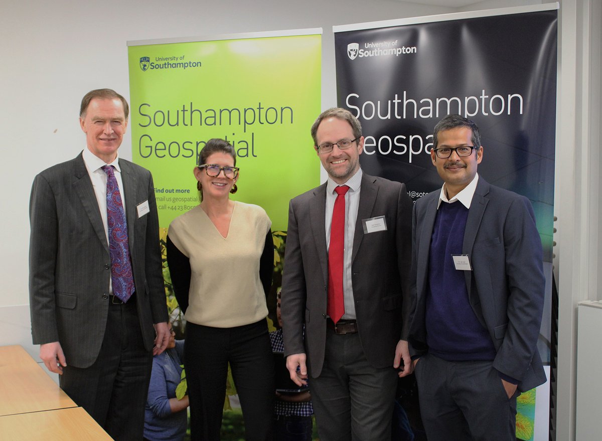
It's great to join forces through this new partnership to enable knowledge sharing and cutting-edge geospatial research to drive greater insights from location data. 👏

It's great to join forces through this new partnership to enable knowledge sharing and cutting-edge geospatial research to drive greater insights from location data. 👏
Ordnance Survey’s Product Managers, Mark Stileman and Chris Heap, share how Britain’s national mapping agency could help customers see the world in more depth and detail. geobusinessshow.com/seeing-the-wor… #realitycapture #3dmodeling #photogrammetry #3dgis #3d #gis
We're excited to join #GITEXGLOBAL Dubai 16th - 20th October. Discover how we can accelerate your progress with our consulting services, unlocking unrivalled location intelligence to benefit people and the economy. @GITEX_GLOBAL
📣 PRODUCT LAUNCH: Introducing the NEW #UltraCamDragon 4.1 - a game-changing HYBRID imaging and LiDAR system. This camera kicks off our INTEGRATED LINE, featuring hybrid-source based aerial mapping systems. ➡️ Press: bit.ly/3ZMi8Rv ➡️ Details: bit.ly/3QkBZEt
📣 PRODUCT LAUNCH: Introducing the NEW UltraCam Merlin 4.1: Your strong base for professional aerial data collection! UltraCam Merlin 4.1: ✔️ available in 2 models ✔️ starts new FUNDAMENTAL LINE ➡️ Press release: bit.ly/3FcHP4m ➡️ More details: bit.ly/3QkBZEt
Exciting News: Unveiling NEW #UltraCam Product Lines! 📣 Vexcel CEO Alexander Wiechert reveals our new UltraCam product lineup, designed to meet all mapping applications. This year, we are introducing TWO remarkable systems! ➡️ FIND OUT WHAT'S NEW: bit.ly/3ZQRSp8
Have you ever spotted the OS plane? May was one of the busiest months for our Flying Team due to the good weather ☀️ This DataViz shows GPS tracks of two of our aircrafts making their way over GB!

We'll be there for you.

Are you already familiar with Aerial Triangulation, one of the key features within UltraMap Studio? It is the process of calculating precise image orientations of an entire image block in a mapping frame. Learn more: bit.ly/3QMsQBa #vexcelimaging #ultramap

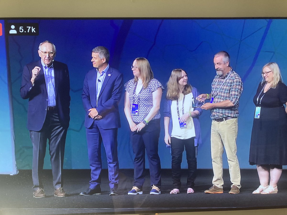
Well deserved @OrdnanceSurvey in winning the 2022 Enterprise GIS award at #EsriUC
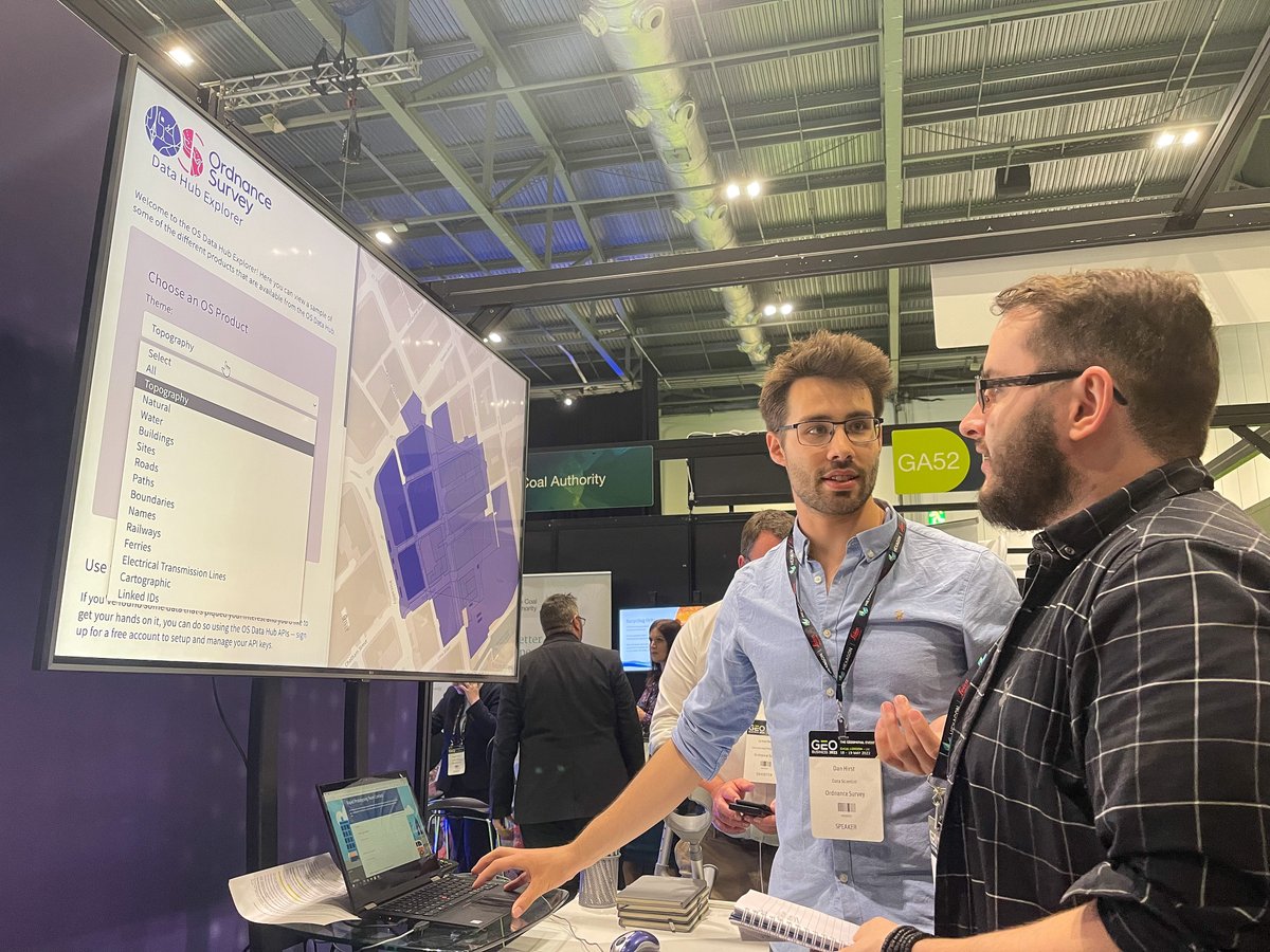
Did you know you can explore OS Data Hub capabilities yourself in our Explorer? Discover more about our open and premium options, and learn more: ow.ly/Bu3X50JjH4g
Excellent reporting.


This meme that's been going around perfectly encapsulates why I avoid shapefiles as much as I can.


Electronic counter measures by Russia to hide military build up? Image from @EarthBlox shows border of #Ukraine in mid-Nov 2021. This is not your usual radio frequency interference on Sentinel1 - more like a saturating signal intended to obscure? #EOChat @wammezz @Steven_Ramage


I'm available for a full time permanent role in the New Year. If you are looking for someone who 'knows enough to be dangerous' please reach out (DM's are open).

The 2022 series of #elearning #courses from EuroSDR is now open for registration 💻📘 Check it out at eurosdr.net/education/cour… #Lidar #CrowdsourcedGeographicInformation #GeoBIM #3DCityModelling #3DPointCloud #EduServ20


Zrajjar @Zrajjar876
2 Followers 133 Following
Ross McDowall @DoppioRoss
61 Followers 956 Following
Adam Dennett @adam_dennett
3K Followers 2K Following Professor of Urban Analytics @CASAUCL. Lover of drum & bass, beer and tattoos. Drummer. Dad. Run a bit. Live in Brighton.
1C3 Jithendra @3Jithendra
3 Followers 46 Following
Engr. Dr. Fiaz Hussai... @engrfiazhussain
453 Followers 2K Following Assistant Professor of Land and Water Conservation Engineering, PMAS-Arid Agriculture University Rawalpindi

Jonathan Amos @JonathanAmosaqe
125 Followers 194 Following
perslab @perslab_auth
478 Followers 3K Following Laboratory of Photogrammetry and Remote Sensing - RSE. Aristotle University of Thessaloniki * Εργαστήριο Φωτογραμμετρίας και Τηλεπισκόπησης - ΤΑΤΜ.ΑΠΘ
NextNav @NextNav
694 Followers 546 Following A leader in next-generation 3D Positioning, Navigation, and Timing (PNT) solutions.
GIS & RS DEPOT @md_sofier
25 Followers 315 Following GIS/RS Analyst Google Earth Engine Expert ArcGIS expert

M Abdullah Khan @Abdullah_khanp7
0 Followers 15 Following
Geosun Navigation @GeosunNav
1K Followers 4K Following Make the LiDAR/SLAM solution more affordable and applicable.
Cunning Running Softw... @CunningRunning
96 Followers 93 Following Cunning Running Software Ltd develops Counter Terrorism and Search software in use by Military and Police users worldwide.
3DMapMemes @3DMapMemes
121 Followers 196 Following Purveyor of Reality Capture, 3D model, and 3D GIS Map memes for those who work in GIS, CAD, VR, AR, XR and Metaverse. @pixelrescue is my main.
Narayan Gadagkar @GadagkarNarayan
0 Followers 66 Following
Radiator @Radiator1981
21 Followers 3K Following
Juliana Trichilo Cina @jtcina
20K Followers 22K Following #SmartSelf Evangelist — Being your best starts w ... #SelfAwareness #Psychology #CriticalThinking #Communication #Data #AI #Innovation #Tech #Business #Ethics
Efstathios Adamopoulo... @StathisAdamo
13 Followers 62 Following
Mehdi @Mehdi451780162
1 Followers 7 Following
Darrin Johnson @darrinpjohnson
4K Followers 4K Following Director of Technical Marketing @NVIDIA for Enterprise #AI #DL #ML #DeepLearning #MachineLearning #HPC #Innovation #RAPIDS #DevOPs *My opinions are my own!*
Dr. Brianna R. Pagán @Brianna_R_Pagan
2K Followers 3K Following Deputy Manager @NASAEarthData GES DISC, Tech Advisor @spacesenseAI, Lecturer @SeaverLMU, Board Member @footprintscamps open source enthusiast, ultra runner 🇵🇷
Sakthivel @sakthigis
436 Followers 4K Following 👨💻Data Science | 🛰Remote Sensing and GIS🌏 | 🏝 Agriculture ⚡ 👉The mind is everything. what you think you become👈
yunjinzh @yunjinzh
313 Followers 2K Following
Steve Attewell @steveattewell
1K Followers 340 Following User Experience Practice Lead @OrdnanceSurvey. My team designs digital mapping applications and helps developers get their hands on complex geospatial data.
Mehrdad @Mehrdad93426992
36 Followers 846 Following
Loreena Jaouen @LoreenaJaouen
30 Followers 156 Following Senior Geospatial Analyst at 2Excel geo. Loving all things Remote Sensing related!
EOchatBot @EOchatBot
717 Followers 526 Following A friendly neighborhood bot for #EOchat, from the #EarthObservation community! #SciComm
Matthew Shields @MShields_esq
62 Followers 435 Following Navigation | Remote Sensing | Data | Sensor Fusion | Statistics | Whitworth Scholar
Wavelength 2025 @rspsoc_wlength
523 Followers 376 Following A remote sensing conference aimed at scientists and engineers in post graduate research or in the early stages of their career. Follow us for updates!
Spectro Expo @SpectroExpo
167 Followers 524 Following Gathering everyone involved in #Spectroscopy or #ImagingSpectroscopy, from #sensor designers to endusers, covering #science/#technology/#applications
Dr Iris Kramer @ickkramer
735 Followers 1K Following Founder of ArchAI (@archai_ltd, https://t.co/4v0du21USs) Forbes 30 under 30 Previous: BA & MSc in Archaeology, PhD in Deep learning
Ka Hei Chow @pinkychow1010
326 Followers 539 Following Earth Observation for Nature Conservation 🌏 Climate Impact Modelling @ Repath 🛰️🌲

XIMEA - Imaging beyon... @ximeagmbh
1K Followers 1K Following The fastest, the lightest, most compact cameras. Tiny board level units, high resolution and high speed PCIe cameras, multi-camera set-ups and embedded Vision.
Stefan Kornaś @twittalegend
158 Followers 339 Following Ordnance Survey Flying Team Manager. Map Man @OrdnanceSurvey #WeAreOS. Avid Bolton Wanderers Fan #WeAreTheOneAndOnlyWanderers. COYWM. Views Very Much My Own.
Miguel Díaz-Silva @DiazSilva_06
65 Followers 643 Following Geógrafo, interesado en los problemas ambientales, análisis del paisaje y sistemas complejos.
cloudeo @Cloudeo_ag
154 Followers 307 Following Meaningful geo-solutions…for anyone #remotesensing #geospatial
Matt @Matt35026596
27 Followers 790 Following
Kel Markert @KelMarkert
2K Followers 1K Following Cloud Geographer @google #EarthEngine ☁️ 🛰️ 🌏 | PhD in Civil Eng (Hydrology) 🌊 | Views and opinions are my own. he/him

Isabel Sargent PhD CS... @DimensionalIz
284 Followers 566 Following Deep machine learning in the geospatial domain - linking government, industry and academia. #womenintech #womenwhocode #WomenInSTEM
NewSpace India @NewSpaceIndia
10K Followers 5K Following Thought leadership for @isro | Podcast https://t.co/0fB8CFCW5O | Discord https://t.co/aQUIDSkskt
Catherine Stone Ryan @GanttCatherine
77 Followers 711 Following EMT Loudoun Rescue, Social Media Strategist
Picterra @picterra
2K Followers 2K Following Picterra provides sustainability leaders with a Mission Control for Environmental Intelligence. Please note that we no longer post on X, find us on LinkedIn.
Dennis Maps @Dennis_Maps
2K Followers 4K Following We are the largest printer of paper #map products in the UK, producing more than two million maps and charts every year. #GetOutside
Claire Mudge @ClaireMudge
152 Followers 1K Following
marco esposito @Marco_at_coseno
120 Followers 232 Following I am managing director at cosine Remote Sensing, and managing director at coseno. I develop airborne and spaceborne optical instruments.
Eleonora_Grilli @EleonoraGrilli4
26 Followers 43 Following
Intel @intel_reed
805 Followers 5K Following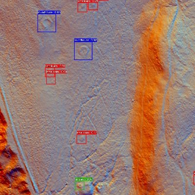
ArchAI @ARCHAI_LTD
625 Followers 364 Following ArchAI uses AI to automatically detect archaeological sites on earth observation data
Zenodo @ZENODO_ORG
8K Followers 95 Following Zenodo, a simple and innovative service enabling researchers to share and showcase research results from all fields of science.
Figshare @figshare
37K Followers 31K Following Figshare is a provider of repository infrastructure. Our solutions help organizations share, showcase and manage their research outputs.
Sketchfab @Sketchfab
66K Followers 2K Following Sketchfab is empowering a new era of creativity by making it easy for anyone to publish and find 3D content online. Use #Sketchfab to share your work with us.
Fab @fab
9K Followers 23 Following Fab gives all digital content creators a single destination to discover, share, buy & sell digital assets. Use #CreatedwithFab to share your creations with us.
3DGeo Research Group ... @3DGeoHD
591 Followers 96 Following 3DGeo Research Group ∙ @UniHeidelberg ∙ Germany Research: #Computational methods for the #geographic analysis of 3D/4D #PointClouds Head: Prof. @BernhardHofle
3DIMPact @UCL_3DIMPact
349 Followers 331 Following 3DImaging, Metrology & Photogrammetry Applied Coordinate Technologies. UCL research group at @UCLGeomatics in @CEGE_UCL and @UCLEngineering.
The Martin Lewis Mone... @itvMLshow
229K Followers 51 Following Hosted by Martin Lewis & Jeanette Kwakye. Page managed by MLMS team. Back on air in Autumn! Vote now for us at the NTAs: https://t.co/JnNLW1DkpR
John Nelson @John_M_Nelson
25K Followers 85 Following Maker of maps. Talker of making of maps. Purveyor of gumption. Mitten State. I make map videos now? https://t.co/lTYF0UBzhp (views mine, etc.)
MBDA UK @MBDA_UK
3K Followers 473 Following MBDA drives #innovation in #defence, pioneering cutting-edge missile systems that proactively address the security challenges of today and tomorrow.
Leonardo in the UK �... @Leonardo_UK
15K Followers 849 Following The official UK account of global security company @Leonardo_live – sharing the latest news from across all our UK sites – from Edinburgh to Yeovil.
The Python Spatial An... @pysal_devs
3K Followers 46 Following The Python Spatial Analysis Library (PySAL) is an Open-Source, Cross-Platform Geospatial Data Science Project.

NovAtel @novatelinc
1K Followers 353 Following NovAtel, part of @HexagonAP, is a global technology leader pioneering end-to-end solutions for assured #autonomy and #positioning on land, sea and air.
Inst of Navigation @ionavigation
2K Followers 142 Following The Institute of Navigation is the world’s premier professional society advancing the art and science of positioning, navigation and timing (PNT).
NextNav @NextNav
694 Followers 546 Following A leader in next-generation 3D Positioning, Navigation, and Timing (PNT) solutions.
Gottfried Mandlburger @GMandlburger
53 Followers 1 Following
The Julia Language @JuliaLanguage
30K Followers 322 Following Julia is a high-level, dynamic programming language built for technical computing. Join the conversation at #JuliaLang @JuliaConOrg @JuliaInclusive
Jonas Bostelmann @JonasBostelmann
774 Followers 919 Following #RemoteSensing with #MachineLearning, Product Owner geoAI @LGLN_Developers #Landesvermessung #Niedersachsen @[email protected]
Dr. Carlos Alberto Si... @Web_LiDAR
3K Followers 332 Following Assistant Professor of Quantitative Forest Science - Forest Biometrics and Remote Sensing Lab (Silva Lab) - University of Florida (UF)
Anna Iglseder @anna_iglseder
126 Followers 145 Following Predoc at @photo_TUW using 💚pointclouds 💚 and other remote sensing data for environmental applications. Research & teaching at @tu_wien and @univienna.
3DForEcoTech @3DForEcoTech
894 Followers 24 Following COST Action CA20118 Three-dimensional forest ecosystem monitoring and better understanding by terrestrial-based technologies
Photogrammetry @ TU W... @photo_TUW
571 Followers 390 Following @phototuw.bsky.social Photogrammetry research unit @geodepartment at @tu_wien. Research on various fields of photogrammetry & developing OPALS software.
Sanna Marin @MarinSanna
614K Followers 619 Following Former Prime Minister of Finland. My upcoming book Hope in Action will be released on November 4th.
Cunning Running Softw... @CunningRunning
96 Followers 93 Following Cunning Running Software Ltd develops Counter Terrorism and Search software in use by Military and Police users worldwide.
GeoParquet @GeoParquet
821 Followers 8 Following A new format for storing geospatial vector data (point, line, polygon), built on Apache Parquet.
Helen McKenzie @helenmakesmaps
13K Followers 1K Following Data & geospatial advocate, content creator & all around map geek @CARTO🌍🌐🗺 Likes: cheese on beans on toast, sitting, otters. Views mine. she/her.
Rafaela Tiengo 🇧�... @RafaelaTiengo_
2K Followers 826 Following Remote Sensing • Earth Observation • Geospatial news 🌍🛰️ (She/her) | ✉️ [email protected]
3DMapMemes @3DMapMemes
121 Followers 196 Following Purveyor of Reality Capture, 3D model, and 3D GIS Map memes for those who work in GIS, CAD, VR, AR, XR and Metaverse. @pixelrescue is my main.
🌳 TLS TREES 🌳 @TLS_TREES
1K Followers 0 Following Tweeting some of the many trees captured by @UCLgeography TLS team. Soon to be bot account, monitored by @kungphil
CCAV @ccavgovuk
3K Followers 369 Following The Centre for Connected & Autonomous Vehicles (CCAV) is an expert UK government unit focussing on Connected and Automated Mobility and the Future of Transport.
Smart Mobility Living... @SMLL_London
847 Followers 260 Following The world’s most advanced urban testbed for #CAV technology of its kind, using a real-world connected environment of public & private roads in London.
Cyclomedia @CycloMedia
846 Followers 754 Following Cyclomedia captures data from the real world and transforms it into valuable insights enabling you to understand the complexities of the environment around you.
Erwan Rivault @ErwanRivault
2K Followers 1K Following Data visualisation designer @BBCNews | previously @ESA_EO
Patrick Cozzi @pjcozzi
5K Followers 547 Following Chief Platform Officer, @BentleySystems | Founder, @CesiumJS
KOREC Group @KORECGroup
3K Followers 2K Following KOREC provides measurement solutions, surveying equipment & mapping systems for the geospatial, engineering & construction sectors in the UK and IRE.
K-MATIC @KOREC_K_MATIC
222 Followers 256 Following Providing customisable solutions for the collection, analysis and processing of #geospatial data
NCTech: virtualizing ... @NC_Tech
2K Followers 1K Following NCTech is a virtual data company, offering an interplay between data capture, creation and interpretation to provide an all-encompassing solution.
Mosaic - Geospatial I... @Mosaic360camera
271 Followers 92 Following Designers and builders of the world's highest resolution 360º cameras for mobile mapping, GIS, VFX, 3D modeling, surveying and so much more.
Kenneth Field @kennethfield
24K Followers 95 Following Cartography is my passion & profession. Author of CARTOGRAPHY. & THEMATIC MAPPING. Maps+drums+beer+snowboards+footy+politics+sarcasm. 🇬🇧 in 🇺🇸. Views mine.

markiliffe @markiliffe
2K Followers 2K Following Geographer and occasional map and policy maker. Views expressed do not represent the institution etc.
Lisa Allen @I_am_LisaAllen
813 Followers 596 Following #data, #environment & #tech | Work @ODIHQ & @DAMAUK | Ex @OrdnanceSurvey Ex @DefraGovUK & Ex @EnvAgency | Views mine only Mastodon @[email protected]
Mark Enzer @enzer_mark
815 Followers 173 Following Strategic advisor at Mott MacDonald. Former Head of the National Digital Twin programme at CDBB. Opinions are my own.
Centre for Digital Bu... @CambridgeCDBB
5K Followers 2K Following CDBB was a partnership between Government and the University of Cambridge to deliver a smart digital economy for infrastructure and construction for the future.
Lilly Thomas @lilly_e_thomas
427 Followers 133 Following Machine Learning Engineer @developmentseed. Other wavelengths include surfing, yoga and design.
Peter Falkingham @peterfalkingham
3K Followers 660 Following Palaeontologist specialising in locomotion in the fossil record, #dinosaur footprints, #photogrammetry and #simulation. (Full) Professor of Palaeobiology

Anthony Steed @anthony_steed
2K Followers 530 Following Professor in Virtual Environments and Computer Graphics at University College London.Trends for United States
You might like